Field Report: Using the Agras T50 for Wildlife Survey Work
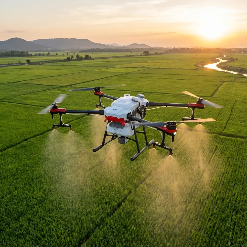
Field Report: Using the Agras T50 for Wildlife Survey Work in Dusty Conditions
META: A field-based expert report on how the DJI Agras T50 performs in dusty wildlife survey operations, with practical insight on RTK fix rate, swath control, nozzle calibration, IPX6K durability, and precision field workflows.
Dust changes everything.
That was the lesson on a dry survey job I still remember too clearly. We were tracking wildlife activity along brittle grassland edges after weeks without meaningful rain. Every vehicle pass threw a brown curtain into the air. Ground teams lost visual clarity. Sensors needed constant wiping. Aircraft that looked fine on paper started showing the small weaknesses that only appear when the environment stops being polite.
That kind of job is where the Agras T50 becomes interesting.
Not because it was originally marketed around wildlife work. It was built for agricultural operations. But in the field, tools often earn their reputation outside their official category. The T50 sits in that zone. For teams surveying wildlife in dusty terrain, especially where repeatable flight lines and reliable low-altitude operation matter more than brochure claims, this platform solves several hard problems at once.
I’m writing this as a consultant, not from a spec sheet obsession. What matters in a wildlife survey mission is whether the aircraft lets you collect usable data, maintain safe spacing from terrain and vegetation, and keep flying without turning every sortie into a maintenance event. The T50 does not replace a dedicated mapping aircraft in every scenario. It does, however, make a very specific kind of dusty, repetitive, operationally messy mission much easier.
Where the T50 fits in wildlife work
When people hear “wildlife surveying,” they often picture a lightweight mapping drone with a visual or multispectral payload. That is one valid approach. But some survey environments are not neat enough for the lightest platforms to remain efficient. Dusty rangeland, dry agricultural interfaces, animal corridors near treated fields, and broad habitat blocks with rough landing areas all reward a machine with more physical resilience and stronger environmental tolerance.
That is where the Agras T50 stands out.
The airframe is designed for hard field conditions. One detail that matters immediately in dusty operations is its IPX6K-rated build. On paper, that rating signals resistance to high-pressure water ingress. In practice, the bigger operational takeaway is that the machine is built with contamination-heavy work in mind. Dust is rarely just dust. It carries fine particles, residue, moisture shifts at dawn, and abrasive grime that finds its way into connectors, hinges, arms, and exposed surfaces. A platform engineered for washdown and harsh agricultural environments gives field crews more confidence when operating in the sort of terrain where wildlife surveys often happen.
That does not mean you ignore maintenance. It means your cleanup protocol becomes manageable instead of constant improvisation.
On one past assignment, the real bottleneck was not battery endurance or route planning. It was confidence. Crews hesitated to push repeated sorties because each landing raised the same question: how much contamination had the aircraft just taken on, and would the next flight expose a fault? With the T50, that psychological drag eases. The aircraft feels like it belongs in a dirty worksite, which matters more than most teams admit.
Why precision matters even when you are not spraying
The T50 is widely associated with application work, so terms like swath width, nozzle calibration, and spray drift usually belong to agronomy discussions. Yet those concepts carry over surprisingly well to wildlife surveying.
Take swath width. In a survey context, the equivalent question is coverage discipline. How wide is each effective pass, and how repeatable are those passes when visibility is compromised by airborne dust? A sloppy overlap pattern creates blind spots, redundant coverage, and inconsistent observational quality. A platform designed around structured, repeatable lane-based work naturally supports better route discipline. That becomes especially useful when teams are surveying movement paths, burrow clusters, nesting edges, or animal pressure near field margins.
Now consider RTK performance. The phrase “centimeter precision” gets thrown around too loosely, but it has real operational value if the fix rate is stable. In dusty wildlife missions, a strong RTK fix rate matters for three reasons.
First, it improves repeatability. If you need to revisit the same corridor, watering point, or habitat boundary over multiple days, you want aircraft positioning that holds its line instead of wandering pass to pass.
Second, it reduces workload on the pilot. Dust already degrades visual cues. The more the aircraft can maintain exact routing, the less cognitive energy goes into correcting drift or manually tightening line spacing.
Third, it strengthens the integrity of any downstream analysis. If your team is correlating visual observations with multispectral indicators, crop edge stress, water access, or disturbance zones, poor positional repeatability weakens the whole exercise.
The T50’s RTK-enabled workflow is one of the strongest reasons it translates better to this kind of work than many people expect. A reliable fix rate is not just a navigation luxury. In dirty field conditions, it is a safety and data-quality tool.
The “spray drone” features that still help survey crews
There is also a practical irony here: some of the features developed for spraying make the T50 better suited to tough wildlife fieldwork.
For example, the machine is built to operate at low altitude over uneven agricultural terrain where precision spacing matters. That operating DNA helps when you need stable movement along vegetation bands, drainage lines, field edges, or open habitat mosaics where animals tend to move. You are benefiting from a flight platform designed to hold consistent patterns close to the ground while managing variable environmental conditions.
Even nozzle calibration, which sounds irrelevant at first glance, has a useful analogy. In agriculture, nozzle calibration is about controlled output and uniform application. In survey operations, the comparable discipline is sensor setup and mission consistency. Teams who come from an application background often bring stronger habits around preflight verification, route consistency, and equipment checks. That mentality matters in wildlife work. If your imaging or observation payload is not consistently configured, your dataset loses value no matter how capable the aircraft is.
And then there is spray drift. Again, not because you are necessarily applying material in a wildlife survey mission, but because drift awareness sharpens your understanding of airflow. Dust behaves like a visual tracer. It shows rotor wash interactions, crosswind tendencies, and the way disturbed air can affect both data capture and animal behavior. Operators with T50 experience tend to read those environmental cues better because they are already trained to think about how airborne particles move across a swath.
That becomes especially important when surveying sensitive species. Rotor wash and dust plumes can alter animal response, obscure visual confirmation, and contaminate the very scene you are trying to document. The T50 gives you enough control authority and route consistency to manage those effects, but only if the operator treats airflow as part of the mission, not background noise.
Dusty habitat edges are where workflows either hold or fail
A lot of wildlife surveying happens at interfaces: crop-to-brush transitions, dry pasture bordering water channels, degraded scrub near service roads, or recovering habitat patches beside active agricultural land. Those are operationally difficult areas because they combine obstacles, inconsistent ground texture, and variable airborne particulate levels.
The T50 handles that setting well for a simple reason: it was made for real field edges, not manicured launch pads.
A machine like this gives crews more flexibility in rough deployment zones. You can establish a repeatable flight routine, maintain a tighter operational cycle, and spend less time babying the aircraft between sorties. That is not glamorous, but it is often the difference between finishing a survey window and losing it to preventable delays.
Where I’ve seen the T50 help most is in repeat missions over habitat corridors that need frequent checks. If your objective is a one-off cinematic wildlife inspection, this would not be my first recommendation. If your objective is disciplined, repeated, dust-tolerant field coverage with dependable positioning, it becomes a serious option.
That distinction matters.
Many UAV buyers ask the wrong question. They ask whether the T50 is a wildlife survey drone. The better question is whether its design strengths line up with the actual friction points of your mission. In dusty conditions, the answer is often yes.
Pairing the T50 with multispectral thinking
The mention of multispectral deserves attention even though the T50 is not typically the first name people raise in narrow remote-sensing conversations.
Wildlife survey teams increasingly work from more than visual observations alone. Habitat quality, moisture patterns, vegetative stress, forage condition, and edge health all shape wildlife distribution. A survey mission in dry terrain is not just about spotting animals. It is about understanding why they are using one corridor and avoiding another.
That is where multispectral thinking changes the mission design.
Even when the T50 is not acting as a pure sensor-first mapping platform, its precise and repeatable routing can support broader workflows that connect direct observations with environmental indicators gathered through complementary systems. If you are tracking wildlife movement across dry agricultural interfaces, centimeter-level repeatability helps align repeated flights with external datasets, ground control points, and habitat change assessments.
In plain language, you stop collecting disconnected snapshots and start building a comparable record.
That is a big operational shift. Teams who only chase sightings often end up with anecdotal output. Teams who combine repeatable routing, disciplined field notes, and habitat indicators create something decision-makers can actually use.
What changed for me after one difficult deployment
The specific challenge that changed my view of the T50 was not dramatic. No crash. No spectacular failure. Just a punishingly dusty survey schedule where every minor inefficiency compounded by the hour.
We needed repeated coverage over dry movement lanes near cultivated blocks. Visibility fluctuated. Landing areas were rough. Crew fatigue rose because every task took longer than it should have. What improved the situation was not a single headline feature. It was the combination of rugged build, reliable route repeatability, and field-ready handling.
That combination is easy to underestimate until you work through a full day in dust.
The T50 did not make the environment easier. It reduced how much the environment could destabilize the mission.
That is an important difference. Serious operators do not expect tools to erase field conditions. They want equipment that narrows the gap between plan and execution. In that sense, the T50 earns its place.
If your team is working through similar conditions and wants a field-oriented view rather than a generic brochure conversation, you can message me here.
Practical advice for teams considering the T50 for dusty wildlife surveys
A few points matter more than the rest.
Do not treat the T50 as a plug-and-play replacement for every survey aircraft. It is best where environmental toughness, repeat routes, and low-altitude operational control carry more value than ultralight portability.
Pay attention to RTK setup from the start. A weak fix rate undercuts one of the T50’s biggest operational advantages. If you want true revisit value, your positioning discipline needs to be as serious as your flight planning.
Build your cleaning and inspection routine around dust, not after it. An IPX6K-rated platform gives you durability headroom, but your field procedure still determines uptime.
Use swath logic even if you are not spraying. Define lane spacing, overlap philosophy, and pass order with the same rigor an application pilot would use. Survey quality improves when coverage is intentional.
And finally, think beyond the aircraft. Wildlife work in dry conditions often produces the best outcomes when flight operations, habitat interpretation, and ground observation are tightly linked. The T50 can anchor that workflow, but it is the workflow that creates value.
The Agras T50 is not a generic answer to every UAV question. For dusty wildlife surveying, that is exactly why it deserves serious attention. Its appeal is not theoretical. It comes from how well its agricultural engineering translates into a setting where dust, repetition, and field durability decide whether your mission stays efficient or starts falling apart.
Ready for your own Agras T50? Contact our team for expert consultation.