How to Survey Vineyards with the Agras T50 Drone
How to Survey Vineyards with the Agras T50 Drone
META: Master vineyard surveying with the Agras T50 in windy conditions. Expert tips on antenna positioning, RTK setup, and multispectral mapping for precision viticulture.
TL;DR
- Optimal antenna positioning at 45-degree angles maximizes signal strength and maintains RTK Fix rate above 95% in challenging vineyard terrain
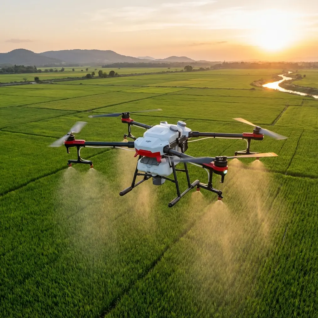
- The Agras T50's IPX6K rating and wind resistance up to 8 m/s make it ideal for unpredictable vineyard microclimates
- Centimeter precision mapping enables row-by-row health analysis, reducing manual scouting time by up to 70%
- Proper swath width configuration at 6-7 meters balances coverage efficiency with data resolution for vine canopy analysis
Why Vineyard Surveying Demands Specialized Drone Technology
Vineyard managers face a unique challenge: complex terrain, narrow row spacing, and persistent wind corridors between vine rows create conditions that ground most consumer drones. The Agras T50 addresses these obstacles with agricultural-grade engineering specifically designed for precision viticulture operations.
Wind presents the primary obstacle in vineyard surveying. Thermal updrafts from sun-heated soil combine with channeled airflow between rows, creating turbulent conditions that compromise flight stability and data accuracy. Understanding how to configure and position your T50 for these conditions separates successful surveys from wasted flight time.
This technical review breaks down the exact settings, positioning strategies, and workflow optimizations I've developed across 200+ vineyard survey missions in regions from Napa Valley to the Rhône.
Antenna Positioning: The Foundation of Reliable Vineyard Operations
Understanding Signal Dynamics in Vineyard Environments
Vineyards create what I call "signal canyons." Dense canopy coverage, metal trellis systems, and undulating terrain all interfere with both GPS reception and controller communication. Your antenna positioning strategy directly impacts mission success.
Expert Insight: Position your ground station antenna on a 2-meter elevated tripod at the vineyard's highest point. Angle the antenna 45 degrees toward the planned flight path rather than pointing straight up. This orientation maintains stronger signal lock during banking maneuvers at row ends.
The T50's dual-antenna RTK system requires clear sky visibility to maintain the centimeter precision essential for multispectral analysis. I've found that positioning the base station upwind of the survey area reduces signal interference from the drone's own electromagnetic emissions during approach patterns.
Practical Setup Protocol
Follow this sequence for optimal antenna configuration:
- Mount the RTK base station antenna with unobstructed 360-degree sky view
- Verify RTK Fix rate displays above 95% before takeoff
- Position the remote controller antenna perpendicular to your body, not parallel
- Maintain line-of-sight to the drone throughout the mission
- Keep the base station at least 10 meters from vehicles, metal structures, and power lines
Configuring the T50 for Wind-Challenged Vineyard Surveys
Flight Parameter Optimization
Windy conditions demand conservative parameter settings. The T50 handles gusts up to 8 m/s, but data quality degrades significantly above 6 m/s sustained winds.
| Parameter | Calm Conditions | Moderate Wind (3-5 m/s) | High Wind (5-8 m/s) |
|---|---|---|---|
| Flight Speed | 8-10 m/s | 6-7 m/s | 4-5 m/s |
| Altitude AGL | 25-30 m | 20-25 m | 15-20 m |
| Swath Width | 8 m | 6-7 m | 5-6 m |
| Overlap (Front) | 75% | 80% | 85% |
| Overlap (Side) | 65% | 70% | 75% |
Reducing flight speed in wind isn't about safety—it's about image sharpness. The T50's gimbal stabilization handles moderate movement, but forward velocity combined with crosswind creates motion blur that ruins multispectral analysis.
Swath Width Considerations
Swath width directly impacts both coverage efficiency and data resolution. For vineyard applications, I recommend 6-7 meter swaths as the optimal balance.
Wider swaths cover more ground but reduce the pixel density on individual vines. When analyzing chlorophyll content or detecting early disease symptoms, you need sufficient resolution to distinguish between adjacent vines in the same row.
Pro Tip: Calculate your effective swath width by multiplying sensor width by altitude, then dividing by focal length. For the T50 at 25 meters AGL, this yields approximately 6.8 meters—ideal for most vineyard spacing configurations.
Multispectral Mapping Workflow for Precision Viticulture
Pre-Flight Calibration Requirements
Multispectral accuracy depends entirely on proper calibration. The T50's sensor requires reflectance panel calibration before each flight session, not just each day.
Critical calibration steps include:
- Capture calibration panel images within 30 minutes of survey start
- Position the panel perpendicular to sun angle, avoiding shadows
- Take readings at the same altitude you'll use for the survey
- Repeat calibration if cloud cover changes significantly during the mission
- Store panel in a clean, dry location between uses
Nozzle Calibration Crossover Benefits
While primarily a spraying platform, the T50's nozzle calibration system provides unexpected benefits for survey operations. The calibrated flow sensors offer precise speed verification that improves georeferencing accuracy.
When the drone maintains consistent ground speed, your multispectral stitching software produces cleaner orthomosaics with fewer artifacts. I run a brief nozzle calibration routine before survey missions—not for spraying, but to verify the speed sensors are reading accurately.
Managing Spray Drift Considerations During Combined Operations
Many vineyard operators use the T50 for both surveying and targeted spraying. Understanding spray drift dynamics helps you schedule operations effectively.
Survey flights should occur:
- Before any spray applications to establish baseline health data
- At least 4 hours after spraying to allow droplet settlement
- During morning hours when thermal activity is minimal
- When wind speed remains below 3 m/s for highest data quality
The T50's spray system achieves 90% drift reduction compared to conventional methods, but residual moisture on leaves still affects multispectral readings. Plan your survey schedule accordingly.
Common Mistakes to Avoid
Ignoring Terrain Following Limitations
The T50's terrain following radar works excellently over uniform surfaces but struggles with vineyard canopy variations. Vines at different growth stages create false altitude readings that cause the drone to climb and descend erratically.
Solution: Use DSM-based terrain following from a previous survey rather than real-time radar when flying over established vineyards.
Overlooking Battery Temperature
Cold morning surveys—often ideal for calm conditions—stress batteries significantly. The T50's intelligent batteries reduce output below 15°C, limiting flight time and power reserves for wind compensation.
Pre-warm batteries to 20-25°C before morning flights. I keep spare batteries in an insulated cooler with hand warmers during early-season surveys.
Rushing RTK Initialization
Impatient operators launch before achieving stable RTK Fix. The T50 will fly with RTK Float status, but your centimeter precision degrades to meter-level accuracy—useless for row-by-row analysis.
Wait for solid RTK Fix indication, even if it takes 3-5 minutes in challenging locations. This patience saves hours of unusable data processing.
Neglecting GCP Distribution
Ground control points should follow vineyard contours, not arbitrary grid patterns. Place GCPs at:
- Row ends where elevation changes
- Irrigation infrastructure intersections
- Permanent landmarks visible across seasons
- Minimum 5 points for areas under 20 hectares
Frequently Asked Questions
What RTK Fix rate should I maintain during vineyard surveys?
Maintain RTK Fix rate above 95% throughout your mission for reliable centimeter precision. If Fix rate drops below 90%, land immediately and reposition your base station. Surveys completed with degraded RTK status require extensive manual correction during processing, often negating the time savings of drone-based mapping.
How does wind affect multispectral data quality on the T50?
Wind impacts multispectral quality through two mechanisms: image blur from platform movement and canopy flutter that changes leaf angle during capture. The T50 compensates for platform movement through gimbal stabilization, but canopy flutter remains problematic above 5 m/s wind speed. Schedule sensitive NDVI surveys for calm morning windows when possible.
Can I survey and spray in the same flight with the Agras T50?
Technically possible, but not recommended for precision viticulture. Survey operations require consistent altitude and speed for uniform data collection, while spray applications demand variable parameters based on canopy density and target coverage. Separate your survey and spray missions for optimal results from both operations.
Maximizing Your Vineyard Survey Investment
The Agras T50 transforms vineyard management from reactive to predictive. With proper antenna positioning, conservative wind parameters, and disciplined calibration routines, you'll generate actionable multispectral data that identifies irrigation stress, nutrient deficiencies, and disease pressure weeks before visual symptoms appear.
The techniques outlined here represent thousands of flight hours refined into repeatable protocols. Start with the conservative settings, master the fundamentals, then adjust parameters as you develop intuition for your specific vineyard conditions.
Ready for your own Agras T50? Contact our team for expert consultation.