Agras T50 for Low-Light Surveying: What Actually Matters
Agras T50 for Low-Light Surveying: What Actually Matters in the Field
META: A practical expert guide to using the Agras T50 for low-light surveying, with lessons drawn from UAV photogrammetry and forest remote-sensing workflows, including data accuracy, RTK discipline, and image quality priorities.
Low-light surveying is where weak workflows get exposed.
By daylight, a drone team can often get away with small mistakes: rushed mission planning, inconsistent overlap, casual ground control, or image settings that look fine on a tablet but collapse during processing. In dim conditions—late afternoon under cloud, tree-edge shade, valley terrain, utility corridors at dusk, or agricultural blocks with heavy canopy contrast—the margin disappears. If you are evaluating the Agras T50 for this kind of work, the right question is not whether it can fly the route. The real question is whether the data chain will still hold together when lighting stops being forgiving.
That is where the reference material tells us something useful.
A 2015 Chinese paper on UAV aerial photogrammetry described a workflow that still captures the heart of reliable survey operations today: image collection alone is never the product. The value comes from disciplined processing into outputs such as DEM, DLG, and DOM, then checking those outputs against field measurements to verify accuracy. That point matters for the Agras T50 because many operators still judge performance by what they saw in the live view, not by whether the mission produced dependable mapping products. In low light, that gap gets bigger. A visually acceptable image can still be weak for triangulation, feature extraction, or terrain interpretation.
Another source, a 2011 forestry remote-sensing study, highlighted why UAVs became so valuable in difficult terrain in the first place. In southern collective forest areas, the authors noted that on-foot investigation required substantial labor, and in many places vegetation growth had erased former forest paths, making ground work extremely demanding. That is more than a historical observation. It is precisely the kind of operating context where a platform like the Agras T50 can create practical value: areas that are accessible by air, hard to traverse on foot, and sensitive to the timing of light.
Why low-light surveying changes the job
Surveying in poor light is not just “normal surveying, but darker.” The technical stress points are different:
- Image contrast falls off.
- Edge detail becomes less distinct.
- Shadowed surfaces lose texture, which hurts tie-point generation.
- Tree crowns, irrigation structures, and terrain breaks can merge visually.
- Wet soil, leaves, and water channels create reflective inconsistencies.
- Any weakness in RTK discipline or overlap planning becomes harder to correct later.
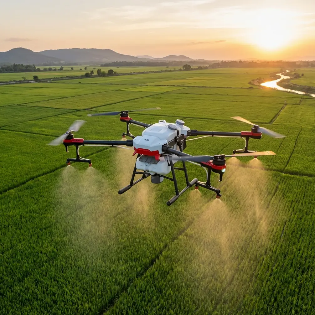
The Agras T50 is often discussed through the lens of agricultural operations—coverage, spraying, flow, field efficiency. But if you are using the platform around survey-related tasks in agricultural estates, plantation blocks, trial plots, access roads, wind development areas, or rural infrastructure, low-light performance should be judged through a photogrammetry mindset, not only a flight-performance mindset.
That distinction is essential.
The old photogrammetry literature referenced a 5 kg payload and 1.5-hour endurance for earlier UAV mapping systems distributed to surveying bodies from 2009 onward. Those numbers are not interesting because they are impressive by today’s standards—they are interesting because they show how much earlier UAV survey work depended on payload discipline, camera choice, and mission planning to get usable large-scale mapping results. Modern operators sometimes assume newer aircraft automatically solve that problem. They do not. Better airframes reduce friction. They do not remove the need for survey logic.
What the Agras T50 does better than weaker alternatives
In mixed-use UAV fleets, the failure mode I see most often is simple: teams use whichever aircraft is available and expect similar survey results across platforms. That is where the Agras T50 can stand apart, provided the team uses it with intent.
Compared with lighter-duty platforms that struggle in wind, carry less stable payload configurations, or lose consistency across large blocks, the T50’s advantage is operational steadiness. That steadiness matters more in low light than many crews realize. When the scene itself offers less visual information, aircraft behavior has to become more predictable. You need cleaner track holding, repeatable swath geometry, and a stronger RTK fix rate if you want centimeter precision to remain realistic across the mission.
A weaker competitor may still complete the route. But route completion is not the same as data confidence.
This is especially true in plantation edges, forestry margins, orchards, and large agricultural venues where lighting shifts every few minutes. If your aircraft drifts slightly on each pass, if the positional solution degrades under obstruction, or if altitude control becomes inconsistent over variable terrain, the resulting model can become noisier than the flight log suggests. The T50’s value in these environments is less about a headline feature and more about maintaining disciplined geometry when light and terrain are both working against you.
The hidden lesson from forest inventory research
The forestry paper is easy to underestimate because it comes from an earlier period of UAV remote sensing. Yet its core insight is current: UAV survey methods become most valuable where ground access is painful and the landscape changes faster than field crews can keep up.
The authors emphasized that traditional field investigation in overgrown southern forest areas demanded major manpower and material input. They also pointed out that rapid vegetation growth could erase paths that once existed, sharply increasing labor intensity. Translate that to today’s reader interested in the Agras T50 and low-light venue surveying:
- plantation and woodland edges may be physically accessible only by long detours,
- pre-dawn or dusk windows may be the only times when site activity is low enough for safe operations,
- terrain shadows may dominate the collection period,
- and the ability to combine aerial capture with GIS and GPS frameworks remains central.
That last point is one of the strongest signals in the source data. The forestry study specifically framed UAV remote sensing together with GIS and GPS. Operationally, that means the drone is not the whole system. The Agras T50 should sit inside a workflow that includes site basemaps, known control logic, consistent coordinate handling, and post-mission validation. If you skip that, low-light flying becomes a visual exercise rather than a survey-grade operation.
A practical low-light surveying workflow for the Agras T50
Here is the approach I recommend when the mission involves difficult light and the output must still be usable.
1. Start with the output, not the aircraft
Before launch, define whether the mission is expected to support a DOM, terrain interpretation, linework extraction similar to DLG, or elevation-related analysis akin to a DEM workflow. The 2015 photogrammetry reference explicitly ties UAV operations to those products. That matters because each output type has a different tolerance for weak imagery.
If your team simply says, “We’ll go collect and see what we get,” low light will punish that casualness.
2. Treat RTK as a discipline, not a checkbox
For the Agras T50, low-light success depends heavily on positional stability. Watch the RTK fix rate through the whole site, not only at takeoff. Tree lines, built structures, and terrain walls can create inconsistent satellite visibility. In marginal light, poor image texture and weak geospatial consistency combine badly.
The goal is simple: reduce the burden on downstream matching by keeping georeferencing clean from the start.
3. Prioritize overlap over speed
Operators sometimes try to preserve productivity by widening swath width or pushing groundspeed late in the day. That can work in bright, high-texture scenes. It is risky in low light. Dim scenes provide fewer robust matching features, especially over uniform crops, damp soil, and shadowed access roads.
If the mission matters, fly more conservatively and build image redundancy. It is easier to defend a slower mission than to explain a broken model.
4. Don’t let agricultural settings bleed into survey assumptions
Because the Agras T50 lives in agricultural discussions, some teams carry over spray-operations habits without realizing it. They think in terms of block completion and path efficiency, which is useful for application work but not enough for surveying.
This is where related concepts like spray drift and nozzle calibration are actually instructive by analogy. In application work, small deviations in droplet behavior or nozzle setup can materially change the result in the field. Surveying is similar: small inconsistencies in altitude, overlap, exposure behavior, or georeferencing may look minor during flight, yet materially affect the deliverable later. Different mission type, same lesson—precision is cumulative.
5. Respect canopy and shadow boundaries
The forestry literature remains relevant here. In wooded or semi-wooded areas, fast vegetation growth and irregular access are only part of the challenge. The visual boundary between open ground and canopy shade is one of the hardest places to maintain reliable feature interpretation.
With the Agras T50, break the site into lighting zones if necessary. An open field edge, a tree-belt transition, and an interior access track may need slightly different timing or flight strategy. One mission plan for all three can be convenient, but convenience does not guarantee a clean data product.
6. Build verification into the job
The 2015 photogrammetry source did something many commercial teams still neglect: it discussed checking DLG and DOM accuracy using measured field data. That is not academic overhead. It is operational insurance.
If the site matters—trial farms, land development, drainage review, forestry boundary work, wind-related site reconnaissance—validate key points on the ground. A low-light mission is not trustworthy because the aircraft performed well. It is trustworthy because the outputs agree with independent reference.
What about sensors and multispectral expectations?
Many readers interested in the Agras T50 ask whether a platform like this should also carry the burden of specialized sensing strategy, especially where multispectral ambitions enter the conversation.
The answer depends on your real objective.
If the task is venue surveying in low light, your first priority is stable geometry, repeatable positioning, and interpretable imagery. Multispectral ambitions are useful only if the mission design, calibration workflow, and environmental conditions support them. Low light narrows that margin. If the purpose is simply to document terrain, access, crop structure, drainage patterns, or block condition at survey level, do not complicate the mission beyond what the conditions can support.
A disciplined visible-spectrum workflow with strong RTK behavior often beats an overcomplicated sensing plan executed in bad light.
Environmental durability still matters
One overlooked reason the Agras T50 can outperform lighter or less robust alternatives in real field environments is not glamorous at all: survivability in dirty, wet, and repetitive operations. When a platform is expected to work across agricultural venues, forest margins, and remote infrastructure areas, environmental protection such as IPX6K-class durability becomes more than a spec-sheet detail.
Operationally, that means less hesitation about mist, residue, splash, and harsh field cleanup cycles. For low-light crews, this matters because the survey window often overlaps with dew, late-day humidity, or post-irrigation conditions. Ruggedness does not improve image quality directly, but it improves mission reliability by reducing the number of small environmental interruptions that push teams into rushed flights.
The human factor is still the decisive one
There is an odd little clue in the non-drone source provided: a smartphone portrait-mode note arguing that parameters are not too difficult for beginners, and citing f/1.8 as a balanced setting because excessive blur or insufficient blur both harm the image.
Even though that source is unrelated to UAV surveying, the underlying lesson transfers cleanly: useful image capture is usually about balance, not chasing extremes.
In drone survey work, the equivalent mistake is pushing one parameter—speed, coverage, altitude, exposure preference, or route width—too far because it sounds efficient. In low light, balance wins. Enough overlap. Enough positional confidence. Enough texture. Enough caution around shadows. The Agras T50 is most effective when flown by a team that understands this restraint.
When the T50 is the right fit
The Agras T50 makes the most sense for low-light surveying support when your site has one or more of the following traits:
- large agricultural or plantation blocks,
- uneven access on foot,
- tree-edge transitions or partial canopy,
- terrain or infrastructure that benefits from repeatable centimeter-grade positioning,
- wet or harsh field conditions,
- and a real need to turn flights into mapping outputs rather than simple visual records.
If that sounds like your operation, the drone’s edge is not just that it can work in challenging conditions. It is that it can support a workflow disciplined enough to still produce useful results after those conditions have done their worst.
If you want help choosing a field-ready setup or refining a low-light mission plan, you can message our Agras specialists here: https://wa.me/85255379740
The best Agras T50 survey results do not come from treating it like a generic UAV. They come from using it as part of a controlled mapping system—one that respects what the older photogrammetry and forestry literature already made clear years ago. Difficult terrain, fading light, and inaccessible ground are exactly where UAVs prove their worth. But only when the operator cares as much about the final data product as the flight itself.
Ready for your own Agras T50? Contact our team for expert consultation.