Agras T50 for Highway Corridors in Extreme Temperatures
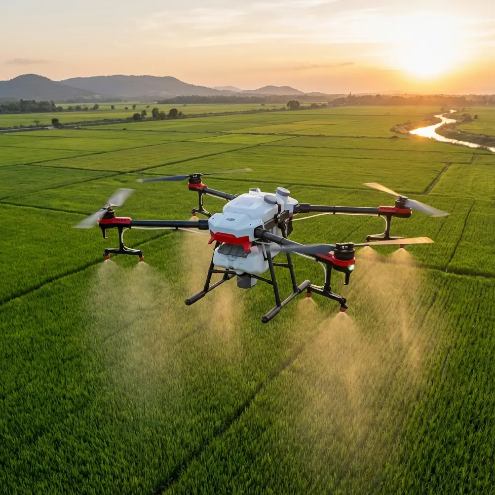
Agras T50 for Highway Corridors in Extreme Temperatures: A Field Report on Precision, Stability, and Low-Altitude Readiness
META: Expert field report on using the DJI Agras T50 for highway corridor work in extreme temperatures, with insight on precision flight behavior, sensor-driven response, and why low-altitude innovation standards now matter.
When people talk about the Agras T50, they usually frame it as a farm workhorse. That misses something important. In the field, especially along highway corridors exposed to punishing heat, cold mornings, wind tunnels between barriers, and long repetitive passes, the real question is not whether the platform belongs in agriculture. The question is whether its flight behavior, positioning reliability, and payload-control logic translate into disciplined corridor operations where consistency matters more than spectacle.
That is where the T50 becomes interesting.
I’m approaching this as a field systems question, not a brochure exercise. Highway-adjacent vegetation management, slope treatment, drainage-line spraying, and right-of-way maintenance all punish weak aircraft behavior. A drone that wanders, overcorrects, or drifts in response to changing surfaces and thermal gradients creates operational drag immediately. You lose precision first, then efficiency, then confidence in your data and application pattern.
The Agras T50 stands out because its strengths align with a kind of flying that rewards obedient aircraft response. That may sound simple, but it is not. The difference between a machine that merely flies and one that holds the commanded attitude cleanly is the difference between acceptable output and repeatable output.
Why highway work is harsher than it looks
A highway corridor is rarely a neutral environment. Asphalt radiates heat. Concrete shoulders produce different thermal signatures than vegetated embankments. Passing traffic changes local airflow. Guardrails, signs, slopes, culverts, and service roads create broken geometry for mission planning. If the job involves targeted application rather than broad-acre uniformity, spray drift and swath width management stop being secondary concerns.
This is also where readers evaluating the T50 often focus on the wrong metric. Raw capacity matters, but only after the aircraft proves it can maintain disciplined tracking. In corridor work, centimeter precision and RTK fix rate are not marketing terms; they are the operating foundation for overlap control, repeat path accuracy, and reduced rework.
A platform that loses composure in crosswinds or temperature swings can still finish a mission. It just does so with more correction, more pilot workload, and less confidence in the final result.
The best comparison isn’t another agricultural spec sheet
One of the more useful reference points for understanding the T50’s value actually comes from outside heavy agricultural spraying. In aerobatic model aircraft training, the defining performance trait of a more capable aircraft is that it “holds the attitude introduced by the pilot” and, in most situations, does only what it is told to do. That idea matters here more than many people realize.
The training reference also makes another sharp point: a better-performing aircraft often demands more precise input, not because it is unruly, but because it responds faithfully. That is exactly the kind of behavior serious operators want in a highway corridor drone. A vague machine can feel forgiving right up until you need repeatability along a narrow strip beside drainage infrastructure or around roadside plantings near hard surfaces.
This is where the T50 has an edge over less refined alternatives. Some competing platforms are adequate in open, forgiving environments, but they begin to show their limits where path discipline and application uniformity matter simultaneously. The T50’s appeal is not just strength. It is controllability under stress.
That distinction becomes obvious when the mission involves variable altitude over embankments, repeated passes near obstacles, and the need to preserve a stable swath width without introducing avoidable drift.
Sensor logic matters more in extreme conditions
Another useful clue comes from an educational drone formation exercise. In that training scenario, two aircraft take off together, and when either drone detects a distance change through a forward TOF ranging sensor or a downward TOF height sensor, the aircraft responds by altering movement. A more advanced variation uses three drones: if any one senses an obstacle, all of them perform a corresponding avoidance or obstacle-crossing action.
On paper, that sounds like simple classroom material. Operationally, it illustrates a deeper point: aerial systems become far more useful when sensing is not passive but tied directly to flight response.
For highway work, that principle is central. A corridor mission is full of changing surfaces and interrupted geometry. The practical value is not the existence of sensing alone. It is the system’s ability to read changes in front and below, then translate those inputs into stable behavior rather than hesitation or overreaction.
The TOF-based training example is especially relevant because it highlights two types of environmental awareness that corridor operators care about every day:
- Forward distance change detection, which matters near signs, vegetation walls, embankment edges, and service structures.
- Downward height sensing, which matters when transitioning across uneven shoulders, drainage cuts, and sloped verges.
The T50’s real-world significance in this context is that a highway mission is often won or lost on how cleanly the aircraft handles these transitions. A drone can have strong payload capability, but if its response to terrain or obstacles is clumsy, nozzle calibration and spray pattern planning become less meaningful because the aircraft itself is introducing inconsistency.
Extreme temperatures expose weak flight discipline
Heat and cold do not merely challenge battery systems. They reveal whether the aircraft’s control behavior remains predictable when lift conditions, component temperatures, and air density shift over the course of the day.
On a summer corridor mission, the surface temperature difference between asphalt and adjacent vegetation can produce subtle but persistent changes in local air behavior. In winter, denser air may sharpen response while also increasing the stakes of precise height and speed control near uneven terrain. In both cases, the operator benefits from an aircraft that tracks straight, requires fewer course corrections, and stays honest to command inputs.
Again, this echoes the aerobatic training reference: the aircraft should not improvise. It should maintain the introduced flight state and avoid surprising the pilot. That same source notes that the aircraft’s line tends to stay straighter and requires less correction from point A to point B. For a T50 operator surveying or treating a highway corridor, that translates directly into better line discipline, more consistent overlap, and cleaner execution when RTK-supported routes are doing the heavy navigational work.
A platform that flies “truer” becomes more than pleasant to use. It becomes measurable operational value.
Why this matters for spray drift and nozzle calibration
Corridor work is unforgiving when application uniformity breaks down. Along highways, off-target deposition is not an abstract compliance issue. It affects adjacent surfaces, non-target vegetation, drainage paths, and maintenance quality.
That makes spray drift control inseparable from flight precision.
Nozzle calibration gets a lot of attention, rightly so. But calibration only performs as intended when the aircraft maintains the expected speed, height, and alignment over the treatment zone. If the platform oscillates, wanders laterally, or struggles to hold line in gusts generated by open lanes and passing vehicles, the most careful nozzle setup can still produce uneven results.
This is where the T50 tends to separate itself from weaker competitors. It is not enough to carry the liquid. The aircraft has to preserve the geometry of application in a broken, thermally unstable environment. Stable swath width depends on stable behavior. That sounds obvious. In practice, it is where many corridor workflows fail quietly.
When operators mention centimeter precision and RTK fix rate, they are really talking about confidence that every pass means what the mission planner thought it meant. That confidence shrinks quickly if the drone’s flight character is loose.
A broader low-altitude shift is taking shape
There is another reason the T50 conversation is becoming more serious right now, and it sits above the aircraft itself. APEC has approved the project titled the “Sustainable Technology Innovation Strategy Development Forum,” project number PPSTI_201_2025, with participation led by China and co-proposed by Hong Kong, Malaysia, Thailand, and Peru. The forum is scheduled for July 22 to 23, 2026, alongside the 2026 International Low-Altitude Economy Expo, and some selected low-altitude innovation cases will be circulated across APEC economies. A formal report will also be published on the APEC website.
This matters because it signals something larger than event programming. Cross-economy visibility changes what counts as a serious low-altitude use case. Highway corridor operations in extreme temperatures may sound niche, but they sit squarely inside the kind of practical, sustainable low-altitude work now being elevated at the policy and innovation level.
Why does that matter to an Agras T50 operator?
Because platforms are no longer being judged only on local utility. They are increasingly part of a regional conversation about scalable, reliable low-altitude systems that support infrastructure, environmental management, and green operations. A machine that can deliver disciplined performance in difficult corridor environments is more likely to fit that emerging standard than one optimized only for ideal-field demonstrations.
In other words, the T50 is not just competing against today’s job list. It is competing against a rising expectation for what professional low-altitude equipment should prove in the field.
What I would watch first in a real deployment
If I were evaluating the T50 specifically for highway corridor work in extreme temperatures, I would not start with the headline payload discussion. I would start with five operational checks:
1. RTK fix consistency along reflective and mixed surfaces
Highway environments can challenge positioning confidence due to repetitive geometry and adjacent infrastructure. Strong fix behavior supports true centimeter precision and cleaner route repeatability.
2. Height stability over embankments and drainage features
A corridor drone must transition across uneven ground without introducing avoidable altitude variation that changes droplet behavior or sensing quality.
3. Straight-line discipline in thermal transitions
Watch what happens when the aircraft moves from cooler vegetation to heat-soaked asphalt margins. Good systems reveal themselves here.
4. Swath width preservation under variable wind angles
Not all wind is “field wind.” Corridor wind can be deflected, accelerated, or interrupted. Stable aircraft response helps protect application geometry.
5. Pilot workload during correction-heavy segments
The best aircraft reduce the frequency and magnitude of manual correction. That becomes a safety and productivity advantage over long missions.
If you want to compare deployment notes with operators working through these exact issues, this direct field coordination channel can help: message the corridor drone team on WhatsApp.
The real takeaway on the Agras T50
The strongest case for the Agras T50 in highway surveying and corridor application work is not that it is powerful. Many heavy-lift drones are powerful. The stronger case is that its mission value grows in environments where precision behavior is under pressure.
That is the key distinction.
The educational formation example with two and three drones shows how meaningful sensor-triggered response becomes when one aircraft’s detection changes collective action. The aerobatic training reference shows why obedient, stable flight behavior matters more than vague “ease of use.” Put those ideas together and you get a useful framework for understanding the T50: a professional aircraft earns trust when it senses cleanly, tracks predictably, and turns operator intent into repeatable results.
For highway corridors in extreme temperatures, that is exactly the test that matters.
Ready for your own Agras T50? Contact our team for expert consultation.