Agras T50 Best Practices for Urban Field Surveying
Agras T50 Best Practices for Urban Field Surveying: Precision Setup, Safer Routes, and Smarter Variable Work
META: Practical Agras T50 field surveying guide for urban-edge farms, covering precision flight planning, obstacle handling, spray consistency, RTK considerations, and antenna positioning for better operational reliability.
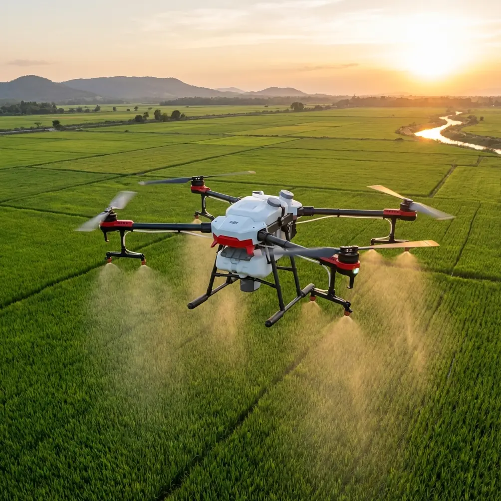
Urban field surveying with an Agras T50 is not just a smaller version of broadacre work. The margins are tighter. Obstacles are less forgiving. Signal environments are messier. A field may sit beside roads, walls, greenhouses, warehouses, scattered trees, or utility structures. That changes how a serious operator should prepare, map, and execute each mission.
The most useful way to think about the T50 in these environments is not as a simple spraying platform, but as a precision agricultural workflow tool. The source materials behind this point are clear. One reference notes that agricultural UAVs are already used across hundreds of crop types, including cotton, orchards, tea, rice, and rapeseed. Another highlights a core operational advantage: the aircraft can follow a planned route with precision, maintain uniform application, and reduce both overlap and missed areas. Those are not abstract benefits. In urban-adjacent plots, they are the difference between clean, controlled work and a field full of inconsistency.
Why urban field surveying demands a different T50 mindset
On an open rural block, a weak route plan might only cost time. In an urban-edge setting, bad planning creates cascading problems. GNSS reflections from nearby structures can affect positioning confidence. Irregular field edges complicate swath alignment. Nearby pedestrian or vehicle activity can force conservative operating buffers. Wind behaves differently around walls and buildings, which matters for both spray drift and data consistency.
That is why surveying should come first, even when the end goal is spraying, spreading, or variable-rate treatment.
The reference material from agricultural drone education emphasizes two practical capabilities that matter here:
- Planned-route precision flight
- Detection-informed variable application
The second point deserves more attention than it usually gets. The source explains that UAVs can carry detection equipment, assess crop disease incidence and severity, and support variable spraying based on pest or disease pressure. For Agras T50 operators, that shifts the mission from “cover everything evenly” to “understand variability, then respond accurately.” In urban agriculture, where plots are often fragmented and input margins matter, that is a major operational advantage.
Start with boundaries, not with the aircraft
Before power-up, walk the field. Not quickly. Properly.
Look for:
- Tree canopies extending beyond the apparent field line
- Guy wires, poles, trellises, netting, and greenhouse edges
- Reflective roofs or glass surfaces that may complicate visual judgment
- Drainage channels, embankments, and abrupt terrain changes
- Adjacent residences, parked vehicles, and public access points
This physical inspection matters because route precision only helps if the digital boundary matches reality. The construction-sector source provides a useful parallel. In complex engineering works such as bridges, dams, and irregular curved structures, UAV-based measurement improves data accuracy where conventional measurement is difficult. Urban plots present a smaller but similar challenge: geometry is messy, edges are imperfect, and visual assumptions fail. Treat the field like a precision survey problem, not a rectangle.
If you are operating near narrow access roads or constrained launch points, choose a takeoff area with the cleanest possible sky view and the lowest risk of electromagnetic interference. That decision improves more than safety. It also supports stronger positioning stability and a better RTK fix rate when available.
Antenna positioning advice for maximum range and link stability
One small setup error causes an outsized number of field complaints: poor antenna orientation.
If your T50 ground control setup uses external or integrated antennas, the goal is not to “point them at the drone” like a laser. It is to maintain the correct orientation for the antenna radiation pattern while preserving the clearest possible line of sight. In practical terms:
- Keep the controller antennas unobstructed by your body, vehicle, or metal structures.
- Stand away from walls, sheet-metal sheds, and parked machinery when establishing the control link.
- Maintain chest-to-head-height controller positioning rather than holding it low near the torso.
- Reposition yourself as the aircraft works behind tree lines, greenhouse corners, or building edges.
For urban field surveying, the best range is often achieved not by standing closest to the field, but by standing where the full route remains most visible from a radio perspective. A launch spot near the middle of the site is not always ideal if a warehouse blocks half the operation.
If your site repeatedly shows intermittent signal quality, move first, troubleshoot second. Many operators waste time adjusting settings when the true issue is antenna shadowing caused by their own position.
If you want a second set of eyes on route layout or controller setup for a difficult site, you can message a T50 operations specialist here.
Build the survey around application quality
The educational drone reference makes a point that directly connects to the T50’s value in fieldwork: UAVs can maintain uniform spray coverage and avoid both repeated application and skipped zones. In real operations, that outcome depends on survey quality.
A good survey should answer four questions before any liquid leaves the tank:
1. What is the true workable swath width?
Catalog numbers are one thing. Field-effective swath width is another. In urban-edge fields, crosswinds, obstructions, and irregular margins often force a narrower practical swath than ideal conditions would allow. If you push width too aggressively, you increase the risk of undercoverage at the edges and drift near sensitive boundaries.
2. Where will drift become unacceptable?
Spray drift is not only a weather issue. It is also a route design issue. If one edge of the field borders homes, roads, or non-target plants, you may need to alter pass direction, reduce speed, revise height, or create no-spray offsets. Surveying should identify those edges early.
3. Which zones actually require the same treatment?
The reference source specifically mentions using detection tools to assess disease severity and perform variable spraying. That means the survey should identify stress patterns, drainage variation, canopy density changes, and recurring edge effects. If one corner of a field has different vigor because of shade or runoff, it should not automatically receive the same treatment as the center.
4. Are all obstacles static?
Urban-adjacent farms often contain moving people, service vehicles, or temporary equipment. A route that was clean at 8 a.m. may not be clean at 10 a.m. Treat obstacle detection as active risk management, not a one-time checklist item.
Obstacle avoidance is operational, not decorative
The source material notes that advanced radar-based obstacle systems can detect an obstacle’s position, distance, movement direction, and speed, then navigate around it autonomously. That is more than a convenience feature. It is one of the most operationally meaningful technologies for complex field layouts.
For T50 users in urban settings, this matters in three ways.
First, it reduces workload during repetitive passes near field-edge obstructions. Second, it improves route continuity where manual corrections would otherwise produce uneven application. Third, it supports safer autonomous work in areas where the environment is visually cluttered.
Still, obstacle sensing is not permission to get casual. Dense branches, wires, fine trellis structures, and partially obscured objects can remain difficult in any real-world sensor stack. The survey phase should aim to simplify the aircraft’s task, not test its limits.
A mature T50 operator uses automation to preserve consistency, not to compensate for avoidable bad planning.
RTK, centimeter precision, and why they matter more on small plots
In large open fields, a modest positional error may be tolerable on a single pass. In small urban-fringe plots, that same error can stack into visible overlap, gaps, and edge excursions. That is where centimeter precision becomes operationally valuable.
Even if your work is primarily agricultural and not formal surveying, the logic from the engineering reference applies. UAV-enabled reconstruction and data comparison are valuable because they allow exact control over the finished outcome. In agriculture, the “finished outcome” is uniform treatment, repeatable route execution, and reliable correlation between observed crop conditions and applied inputs.
A higher RTK fix rate supports:
- Cleaner repeat missions
- Better alignment on narrow or irregular plots
- More reliable route recovery after pauses
- Tighter control near non-target boundaries
If RTK performance drops near buildings or reflective surfaces, do not ignore it and hope the route “looks fine.” Adjust takeoff position, review satellite visibility, and consider whether the site geometry is creating multipath effects.
Nozzle calibration is where precision becomes real
Surveying and mapping create the plan. Nozzle calibration turns the plan into biology and chemistry on target.
The source material emphasizes uniform application and the reduction of both overspray and missed spray. That operational result depends heavily on calibration discipline. If output is inconsistent, even a perfect route map will produce poor agronomic outcomes.
For T50 work in constrained plots:
- Verify nozzle condition before each session
- Check for partial blockage, uneven fan pattern, or wear
- Match pressure, speed, and droplet strategy to crop and boundary sensitivity
- Reconfirm flow performance after changing product type or concentration
- Reassess setup when wind shifts, especially near hardscape or structures
In urban-edge operations, nozzle errors carry extra consequences. A slight imbalance that might go unnoticed in a large remote field becomes obvious when one pass runs close to a greenhouse wall, a perimeter hedge, or a neighboring crop row.
Multispectral thinking, even when the mission is practical
Not every T50 operator runs a formal multispectral workflow, but the underlying principle from the reference material is still useful: detect crop condition, classify severity, then vary the response.
A practical field survey should look for:
- Changes in canopy density
- Repeated stress zones
- Standing water effects
- Edge shading from buildings or trees
- Areas of likely disease progression
The educational source directly references assessing disease incidence and severity, then performing variable treatment. That is the mature model for T50 use. You are not simply flying over crops. You are building a treatment map from observed field reality.
This becomes especially valuable in urban agriculture, where land parcels are often smaller and every square meter has higher management value. Precision is not just about technology. It is about avoiding blanket decisions where the field is clearly telling you something more specific.
Weather, surface effects, and the overlooked urban wind problem
Operators often check wind at takeoff and stop there. That is not enough in built-up areas.
Structures alter airflow. A field bordered by walls or sheds can produce rolling gusts, dead zones, and directional shifts over short distances. That affects drift, hover stability, and droplet placement. A route that appears acceptable from one edge may behave differently near the opposite boundary.
During the survey phase, note:
- Wind funneling between structures
- Calm pockets near walls
- Turbulence at tree lines
- Updraft or rotor effects near sloped embankments or large roofs
If the field sits between built features, conservative mission settings usually outperform aggressive ones. A narrower swath width with better placement is often the more profitable choice than broad coverage that introduces uncertainty.
Borrow a lesson from logistics: autonomy only works when the path is clean
One source example describes drone delivery completing a drop in 13 minutes after ordering, while another educational scenario imagines fulfillment in under 30 minutes. Those examples come from logistics, not crop work, but they illustrate a principle that applies directly to the T50: autonomous performance is strongest when the route, destination, and environment are clearly defined.
The same is true in field surveying. If the launch point is poor, the route is approximate, and the field edge is ambiguous, autonomy loses its advantage. If the site is well characterized, the aircraft can execute with the kind of consistency that makes variable application and efficient repeat missions genuinely useful.
The practical standard for T50 operators in urban field work
A high-level T50 operation in an urban-edge field should look like this:
- Survey the real-world field geometry before building the mission
- Select a launch point for line of sight and signal quality, not convenience
- Optimize antenna positioning to reduce blockage and preserve range
- Validate RTK stability if precision alignment matters
- Build routes around drift-sensitive boundaries
- Use obstacle systems as support, not as a substitute for planning
- Calibrate nozzles carefully so route accuracy translates into actual application quality
- Let observed crop variability drive treatment decisions
The key insight from the reference data is simple but powerful. Agricultural UAVs are effective because they combine precise route following, uniform coverage, and detection-led variable action. The engineering reference adds another layer: in complex environments, drone-based measurement and data comparison improve control over the final result. Put together, those ideas describe exactly how the Agras T50 should be used in urban field surveying.
Not as a flying tank.
As a precision field instrument that earns its keep through cleaner data, steadier execution, and fewer avoidable mistakes.
Ready for your own Agras T50? Contact our team for expert consultation.