Agras T50 in Windy Spraying Conditions: A Technical Review
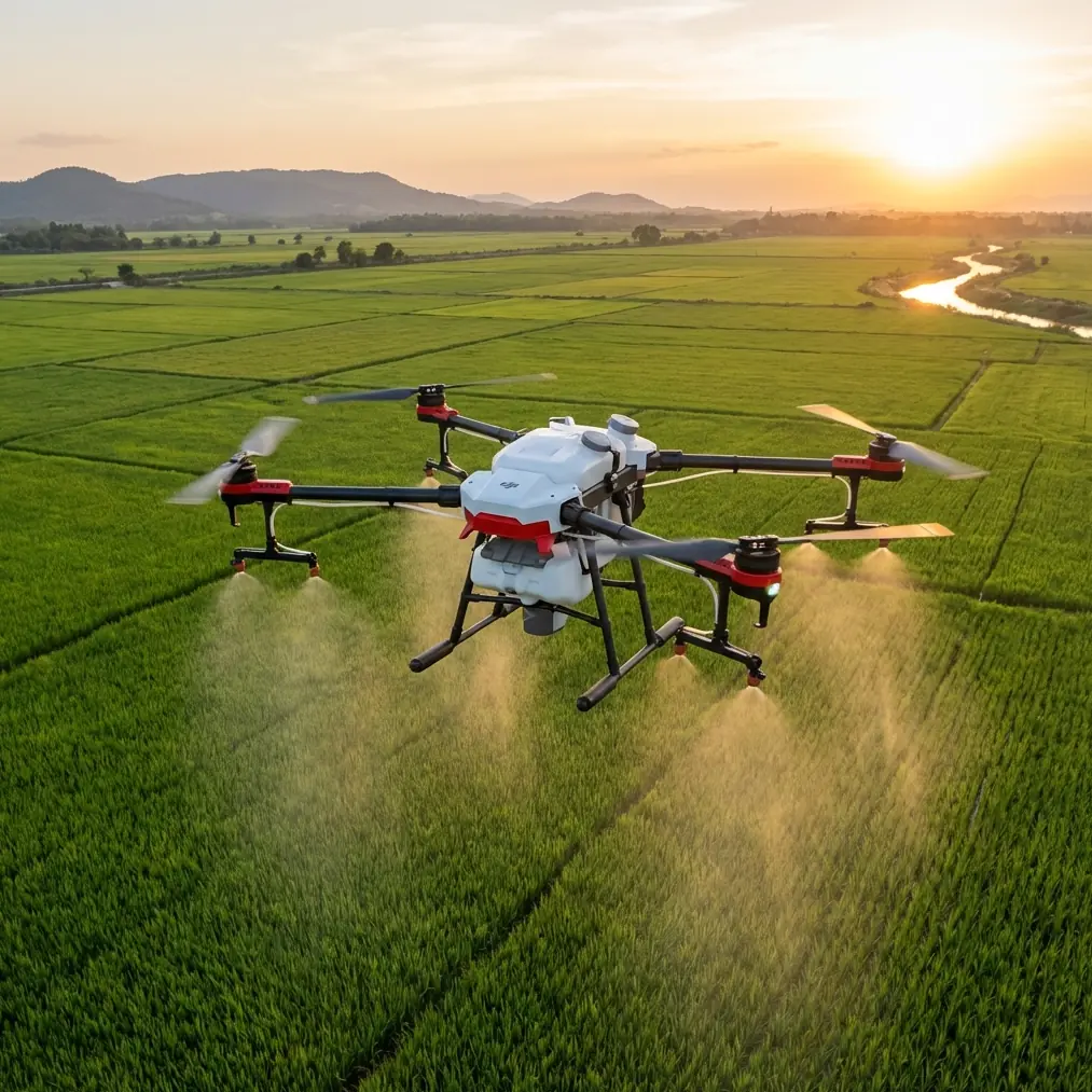
Agras T50 in Windy Spraying Conditions: A Technical Review from the Field
META: A field-driven technical review of the Agras T50 for windy spraying work, with practical insight on spray drift, nozzle setup, positioning reliability, and data workflows that matter in real operations.
Wind changes everything.
Anyone who has run agricultural drone spraying in exposed fields knows the pattern: a machine that looks excellent on paper can become frustrating the moment crosswinds start pushing droplets off line, lifting fines above the canopy, or forcing repeated passes just to maintain coverage confidence. I’ve dealt with that problem on uneven blocks, on open-field edges, and in sites where the crop itself created turbulence. The drone is only one part of the answer. The rest is setup discipline, positional stability, and a workflow that lets you verify what really happened after the flight.
That is the right lens for evaluating the Agras T50.
This is not a generic “big drone equals better results” argument. The real question is whether the T50 makes windy spraying easier to manage in a way that improves consistency, reduces rework, and gives operators better control over drift risk. From that standpoint, the T50 deserves attention not because it eliminates wind limitations—it does not—but because it supports a more controlled spraying system when conditions are less forgiving.
The real problem in windy spraying is not just drift
Most operators use “spray drift” as shorthand, but in practice several different failures get bundled together:
- droplets moving laterally beyond the intended swath
- uneven deposition across the width of the pass
- inconsistent canopy penetration
- overlap errors caused by line deviation
- pressure and atomization choices that are acceptable in calm air but unstable in gusts
The Agras T50 fits into this conversation as a platform built for structured, repeatable application rather than improvised field flying. That distinction matters. In wind, small inconsistencies stack up quickly. If the aircraft wanders, if the fix rate drops, if nozzle calibration is neglected, or if the planned swath width is too optimistic, coverage quality can fall apart even when the aircraft itself stays airborne comfortably.
The better approach is to treat the T50 as a precision application tool first and a lifting platform second.
Centimeter precision matters more when the weather is working against you
One of the most underappreciated factors in windy spray work is line discipline. When operators talk about “handling wind,” they often focus on airframe stability. I care just as much about whether the aircraft repeatedly hits the line it was supposed to fly.
That is where centimeter precision and RTK-based positioning become operationally significant. In variable wind, every small deviation can widen or compress effective spacing between passes. If your intended swath width is, say, aggressive for the droplet spectrum you’re using, even modest lateral drift in the aircraft path can create untreated strips on one side and excessive overlap on the other. The result is not just wasted liquid. It is inconsistent agronomic performance.
With a platform like the Agras T50, the value of a strong RTK fix rate is straightforward: the more reliably the aircraft holds its mapped route, the more confidently you can tune application geometry for real field conditions instead of building in wide safety margins everywhere. In calm weather, mediocre positioning may only be inefficient. In wind, it becomes a quality problem.
That is why I advise teams to stop treating route accuracy as a mapping feature and start viewing it as a spray quality variable.
Windy venues expose weak calibration habits
I’ve seen operators blame wind for what was really a nozzle issue.
The T50 can only perform as well as the spray system setup allows. Nozzle calibration is not glamorous, but it becomes decisive when conditions are difficult. In still air, a slightly uneven output pattern may pass unnoticed. Under wind load, that same imbalance amplifies across the swath. One side of the pattern may be carried farther than intended, while the other falls short of target density.
The practical takeaway is simple: on the Agras T50, nozzle calibration should be checked as part of the windy-day operating routine, not treated as a periodic maintenance afterthought. Flow consistency, droplet behavior, and spray distribution all need to be evaluated together. If operators adjust flight speed or swath width in response to wind without confirming nozzle performance first, they are compensating blindly.
This is one reason the T50 tends to feel “easier” for experienced crews. A mature application platform encourages a disciplined process. Once that process is in place, the machine becomes more predictable. Predictability is what you want when the environment is not.
Swath width should be earned, not assumed
Every drone operator has seen this mistake: take the maximum practical swath from a calm-day job, use it again in a breezy venue, and hope the coverage remains acceptable.
It rarely does.
For the Agras T50, swath width should be treated as a variable that depends on crop structure, wind direction relative to pass lines, release height, and droplet profile. A wide swath looks efficient until you review deposition results and realize the middle performed well while the margins did not. In exposed blocks, the outer edges of the spray pattern are the first to become unreliable.
What the T50 gives you is the platform stability and route repeatability to shrink swath width intelligently rather than reactively. That difference matters. Reducing width is not a defeat; it is often the right way to preserve effective coverage in wind without chasing the problem through repeated touch-up missions.
I tell clients to think in terms of verified productivity, not theoretical productivity. One clean application at a conservative spacing beats one optimistic run followed by corrective passes every time.
Field data is where good spraying decisions get validated
A useful clue comes from the reference material around ArcGIS-based UAV workflows. In one example, source imagery is stored in a project folder and georeferenced in WGS 84. In another, the workflow shows 523 images being brought into a project, where the photos are placed on the map based on metadata and connected into a visible flight path. That may sound like a mapping detail unrelated to the Agras T50, but it actually points to something bigger: serious UAV operations depend on traceable, spatially organized data.
Why does that matter for windy spraying?
Because wind complaints are often anecdotal until you connect them to actual route evidence. If your field team can review geotagged imagery, metadata, and trajectory information inside a coherent GIS workflow, they can investigate whether a suspected coverage issue was tied to a specific section of the route, a turn, a gust-exposed boundary, or an altitude inconsistency.
The WGS 84 detail is especially relevant because standardized coordinate handling makes it easier to compare missions, overlay field boundaries, and align spray activity with scouting or survey results later. If you are already using drone data for crop inspection, integrating spray operations into that same spatial framework leads to better decisions. The Agras T50 benefits from that operational maturity. It is not just about flying and spraying; it is about building a repeatable, reviewable application record.
Even the altitude values shown in the reference extracts—around 605.109 and 604.709 for early images—illustrate a practical point. Small elevation differences across a site can influence effective spray height above canopy if the terrain or crop profile is irregular. In wind, that changes deposition behavior. Teams that ignore terrain nuance and rely on “flat field assumptions” usually discover inconsistencies too late.
Why multispectral context can improve T50 spray planning
Multispectral data is not a built-in cure for drift, but it can make the T50 more effective by improving where and how you spray. In windy conditions, targeted treatment becomes more valuable because every unnecessary pass creates additional exposure to off-target movement.
If a multispectral workflow identifies stressed zones, variable biomass, or areas with uneven canopy closure, the operator can adapt the mission plan instead of applying a one-size-fits-all pattern across the whole block. That can mean segmenting treatment windows, adjusting expectations for deposition, or scheduling the most sensitive areas during calmer periods.
This is where the T50 fits into a broader agronomic workflow rather than acting as a standalone machine. The drone becomes stronger when it is part of a decision loop: scout, map, plan, spray, verify. Windy venues punish guesswork. Data reduces guesswork.
IPX6K matters because agricultural work is messy, not because it sounds impressive
One of the more practical attributes associated with serious ag platforms is environmental resilience. IPX6K is not the sort of specification that makes a spray result better by itself, but it affects uptime and confidence in the field. Agricultural spraying is wet, dirty work. Chemical exposure, rinse-down cycles, residue accumulation, and repeated deployment in imperfect conditions all test the platform.
For the Agras T50, an IPX6K-class durability mindset matters because spraying crews do not operate in laboratory conditions. They work around mixing points, muddy access routes, and fast turnarounds. A machine that tolerates those realities supports better execution over the course of a season. In windy venues, where timing windows can be short, reliability is not a luxury. If conditions finally settle into an acceptable band for treatment, the aircraft needs to be ready.
My biggest shift with the T50: less reacting, more planning
The first time I started trusting larger-format ag drones in wind was when I stopped using them like oversized manual sprayers and started using them like controlled application systems.
That is the shift the Agras T50 encourages.
With the T50, the better mindset is to predefine your compromises:
- choose a conservative swath width when crosswind risk is present
- verify nozzle calibration before loading a full workday schedule
- monitor RTK fix rate as a spray quality input, not just a navigation status
- use centimeter-level route control to protect spacing consistency
- bring imagery and mission records into GIS when post-flight validation matters
This is not romantic drone flying. It is operational agriculture. That is why it works.
If your team is trying to improve T50 performance in windy venues, the real gains usually come from process discipline rather than chasing dramatic hardware narratives. Better route holding reduces overlap problems. Better calibration improves distribution. Better data review exposes weak assumptions. Better planning cuts avoidable passes.
The Blue UAS story is not about the T50, but it highlights a larger trend
One of the reference items mentions WISPR Systems’ SkyScout 2+ being added to the Blue UAS Cleared List, with the designation granted by the Defense Contract Management Agency, validating the platform for federal, public safety, and regulated commercial operations. That aircraft is not the Agras T50, and it serves a different market context. Still, the significance is worth noting because it reflects a broader industry direction: professional drone use is increasingly defined by trust, validation, and suitability for regulated work.
That same expectation is now showing up in agriculture. Growers and service providers want more than a machine that can lift and spray. They want traceability, dependable workflows, and operational consistency that can stand up to scrutiny. In that sense, the T50’s relevance is not just its payload category or field speed. It is whether it fits into a disciplined commercial operation where decisions can be justified and results can be reviewed.
That is also why support matters. If you are dealing with drift-sensitive sites, route planning questions, or setup tradeoffs for difficult weather windows, it helps to talk through the application logic with someone who actually understands agricultural drone operations. If you want to compare field scenarios or troubleshoot a windy-site workflow, you can message a T50 specialist here.
Final assessment
The Agras T50 is at its best when treated as a precision spraying platform built for real agricultural constraints. In windy venues, it does not suspend physics. What it does offer is a better framework for managing them.
Its operational value shows up in the details: stable, repeatable flight lines; the importance of strong RTK fix rate; disciplined nozzle calibration; realistic swath width decisions; and a data-aware workflow that can tie field outcomes back to mapped evidence. The ArcGIS references reinforce that point. A project structure using WGS 84, a mapped image set of 523 photos, and metadata-linked flight tracks all reflect the kind of evidence-based drone operation that commercial spraying increasingly demands.
If your past frustration with agricultural drones came from windy-day inconsistency, the T50 will not reward casual use. It rewards method. For experienced operators, that is precisely the appeal.
Ready for your own Agras T50? Contact our team for expert consultation.