Expert Spraying with Agras T50 in Complex Terrain
Expert Spraying with Agras T50 in Complex Terrain
META: Master complex terrain spraying with the Agras T50. Learn pre-flight protocols, nozzle calibration, and RTK setup for precision agriculture results.
TL;DR
- Pre-flight cleaning of safety sensors prevents mid-operation failures and ensures obstacle detection accuracy in complex terrain
- RTK Fix rate above 95% is essential for centimeter precision when navigating valleys, slopes, and irregular field boundaries
- Nozzle calibration combined with swath width adjustment reduces spray drift by up to 70% in challenging wind conditions
- IPX6K rating allows continuous operation during unexpected weather changes common in mountainous regions
Why Complex Terrain Demands a Different Approach
Standard agricultural drones fail in complex terrain. Hills create unpredictable wind patterns. Valleys block GPS signals. Irregular boundaries make autonomous flight paths unreliable.
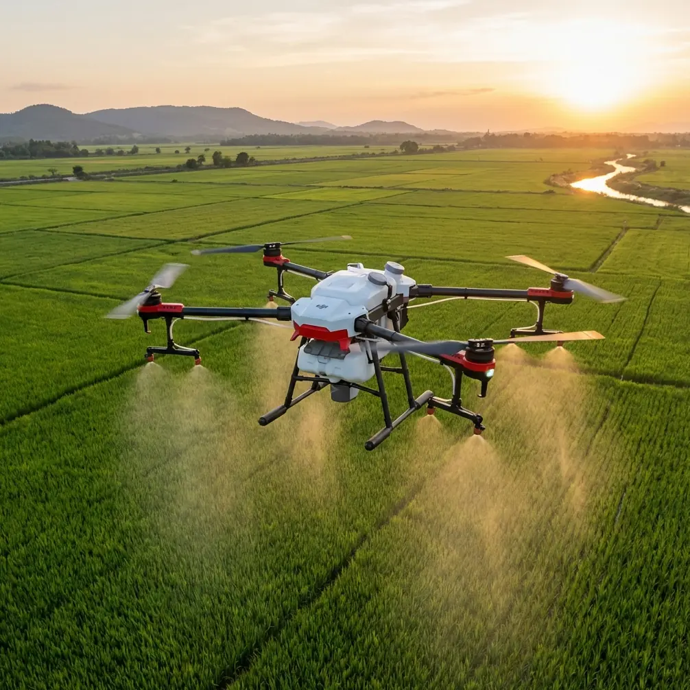
The DJI Agras T50 addresses these challenges with a 50kg payload capacity, dual atomized spraying system, and terrain-following radar that maintains consistent height across slopes up to 50 degrees.
This tutorial walks you through the complete workflow for spraying venues in complex terrain—from the critical pre-flight cleaning step that most operators skip to advanced RTK configuration for maintaining centimeter precision in GPS-challenged environments.
The Pre-Flight Cleaning Protocol Most Operators Ignore
Before discussing flight parameters or spray settings, we need to address the single most overlooked safety step: cleaning the obstacle avoidance sensors.
Why Sensor Cleaning Matters in Complex Terrain
The Agras T50 features a binocular vision system and spherical radar for omnidirectional obstacle detection. In complex terrain, these sensors encounter:
- Dust kicked up from unpaved access roads
- Pollen and plant debris from low-altitude operations
- Morning dew condensation that distorts optical readings
- Residual spray drift from previous operations
A 2mm film of agricultural residue on the front-facing cameras can reduce obstacle detection range from 50 meters to under 15 meters. In terrain with sudden elevation changes or unexpected obstacles like power lines, this degradation becomes dangerous.
Step-by-Step Sensor Cleaning Process
- Power down completely before any cleaning
- Use microfiber cloths only—paper towels scratch optical surfaces
- Clean the spherical radar dome with isopropyl alcohol (70% concentration)
- Inspect the terrain-following radar on the underside for mud or debris
- Verify camera lens clarity by checking live feed before takeoff
Expert Insight: Schedule sensor cleaning every 3 flight cycles in dusty conditions, not just at the start of each day. Accumulated debris during operations causes more failures than overnight contamination.
Configuring RTK for Centimeter Precision in Valleys
Complex terrain creates GPS multipath errors. Signals bounce off hillsides, creating position inaccuracies of 2-5 meters—unacceptable for precision spraying where overlap or gaps waste chemicals and damage crops.
Understanding RTK Fix Rate
The RTK Fix rate indicates the percentage of time your drone maintains centimeter-level positioning. For complex terrain operations, you need:
- Minimum 95% Fix rate for standard operations
- 98%+ Fix rate for operations near structures or power lines
- Real-time monitoring to pause operations when Fix rate drops
Network RTK vs. Base Station Setup
| Configuration | Best For | Fix Rate Stability | Setup Time |
|---|---|---|---|
| Network RTK | Areas with cellular coverage | High (99%+) | 5 minutes |
| D-RTK 2 Base Station | Remote locations without cellular | Very High (99.5%+) | 15-20 minutes |
| Dual Configuration | Critical operations in variable terrain | Maximum redundancy | 25 minutes |
For complex terrain, I recommend the D-RTK 2 Mobile Station positioned on the highest accessible point overlooking your operation area. This eliminates cellular dependency and provides consistent correction signals even in valleys.
Optimal Base Station Placement
Position your RTK base station following these guidelines:
- Minimum 10 meters from vertical obstructions
- Clear sky view of at least 300 degrees
- Stable surface that won't shift during operations
- Elevated position relative to the spray area when possible
Pro Tip: In deep valleys, place the base station on the valley rim rather than the floor. The correction signal broadcasts downward more effectively than upward through terrain obstacles.
Nozzle Calibration for Spray Drift Control
Spray drift wastes chemicals, damages neighboring crops, and creates environmental compliance issues. In complex terrain, unpredictable wind patterns make drift control even more critical.
Understanding the Agras T50 Spraying System
The T50 features a dual atomized spraying system with:
- 16 nozzles across the spray boom
- Droplet size range of 50-500 microns
- Flow rate up to 16 L/min
- Effective swath width of 9-11 meters
Calibrating for Wind Conditions
Wind speed in complex terrain varies dramatically with elevation and position. A valley floor might show 2 m/s while the ridge experiences 8 m/s.
Follow this calibration protocol:
- Measure wind at multiple elevations using the drone's onboard sensors during a test hover
- Set droplet size to 200-300 microns for moderate wind (3-5 m/s)
- Increase to 350-500 microns when wind exceeds 5 m/s
- Reduce swath width by 15-20% in gusty conditions to ensure overlap
Swath Width Adjustment Table
| Wind Speed | Recommended Droplet Size | Swath Width Adjustment | Flight Speed |
|---|---|---|---|
| 0-2 m/s | 130-200 microns | Full width (11m) | 7 m/s |
| 2-4 m/s | 200-300 microns | 10m | 6 m/s |
| 4-6 m/s | 300-400 microns | 8.5m | 5 m/s |
| 6+ m/s | 400-500 microns | 7m or pause | 4 m/s |
Integrating Multispectral Data for Targeted Application
The Agras T50 supports integration with multispectral imaging data, enabling variable-rate application that reduces chemical usage by 20-40% while improving crop outcomes.
Pre-Flight Multispectral Mapping
Before spraying operations, conduct a mapping flight using a multispectral-equipped drone like the DJI Mavic 3 Multispectral. This generates:
- NDVI maps showing vegetation health variations
- Prescription maps for variable-rate application
- Boundary files that account for terrain irregularities
Importing Prescription Maps
- Export prescription maps in shapefile format
- Import to DJI SmartFarm platform
- Sync to the T50 controller via cloud connection
- Verify zone boundaries match actual field conditions
The T50's AI-powered flight planning automatically adjusts spray rates based on prescription zones while maintaining terrain-following accuracy.
Common Mistakes to Avoid
Mistake 1: Ignoring Terrain-Following Radar Calibration
The terrain-following radar requires calibration when operating on slopes exceeding 25 degrees. Without calibration, the drone maintains incorrect height relative to the actual ground surface, causing uneven application.
Solution: Run the terrain calibration routine in DJI Agras app before each operation in new terrain.
Mistake 2: Using Network RTK in Remote Locations
Operators often assume cellular coverage exists because their phone shows signal. Agricultural operations frequently occur in areas where data connectivity is insufficient for RTK corrections.
Solution: Always carry the D-RTK 2 base station as backup, regardless of expected cellular coverage.
Mistake 3: Maintaining Constant Flight Speed on Slopes
Flying uphill requires more power, reducing effective spray coverage. Flying downhill at the same speed creates overlap and waste.
Solution: Enable automatic speed adjustment in terrain mode, which compensates for elevation changes.
Mistake 4: Skipping the IPX6K Verification
The T50's IPX6K water resistance rating protects against high-pressure water jets, but only when all port covers are properly sealed.
Solution: Verify all USB, charging, and maintenance port covers are fully closed before operations where weather may change.
Mistake 5: Neglecting Battery Temperature in Mountain Operations
Mountain terrain often means significant temperature variations. Batteries perform differently at 2,000 meters elevation compared to sea level.
Solution: Pre-warm batteries to 25-30°C before flight and monitor temperature throughout operations.
Frequently Asked Questions
How does the Agras T50 maintain spray accuracy on steep slopes?
The T50 uses a combination of terrain-following radar and downward-facing vision sensors to maintain consistent height above the crop canopy. On slopes up to 50 degrees, the system automatically adjusts rotor speed and attitude to keep the spray boom parallel to the ground surface. This maintains uniform swath width and droplet distribution regardless of terrain angle.
What RTK Fix rate is acceptable for complex terrain spraying?
For precision agriculture applications, maintain a minimum 95% RTK Fix rate throughout operations. When the Fix rate drops below this threshold, the drone's positioning accuracy degrades from centimeter-level to meter-level, causing spray overlap or gaps. The DJI Agras app displays real-time Fix rate—pause operations immediately if it falls below 90% for more than 10 seconds.
Can the Agras T50 operate safely near power lines in complex terrain?
Yes, with proper precautions. The T50's spherical radar system detects obstacles including power lines from 50 meters in optimal conditions. For operations near power infrastructure, enable enhanced obstacle avoidance mode, reduce maximum flight speed to 5 m/s, and maintain a minimum 10-meter horizontal buffer from any power lines. Always conduct a visual survey of the area before autonomous operations.
Achieving Consistent Results in Challenging Environments
Complex terrain spraying requires more preparation than flatland operations. The Agras T50 provides the hardware capabilities—50kg payload, centimeter RTK precision, terrain-following radar, and IPX6K durability—but consistent results depend on proper protocol execution.
Start every operation with sensor cleaning. Verify RTK Fix rate before committing to autonomous flight. Calibrate nozzles based on actual wind conditions at operating altitude, not ground-level measurements.
The investment in proper setup pays dividends through reduced chemical waste, better crop outcomes, and equipment longevity.
Ready for your own Agras T50? Contact our team for expert consultation.