Agras T50 on Complex Terrain: How to Set Flight Height
Agras T50 on Complex Terrain: How to Set Flight Height, Control Drift, and Keep Coverage Consistent
META: Expert how-to for spraying complex terrain with the Agras T50, including flight altitude strategy, drift control, nozzle calibration, RTK precision, and practical field setup.
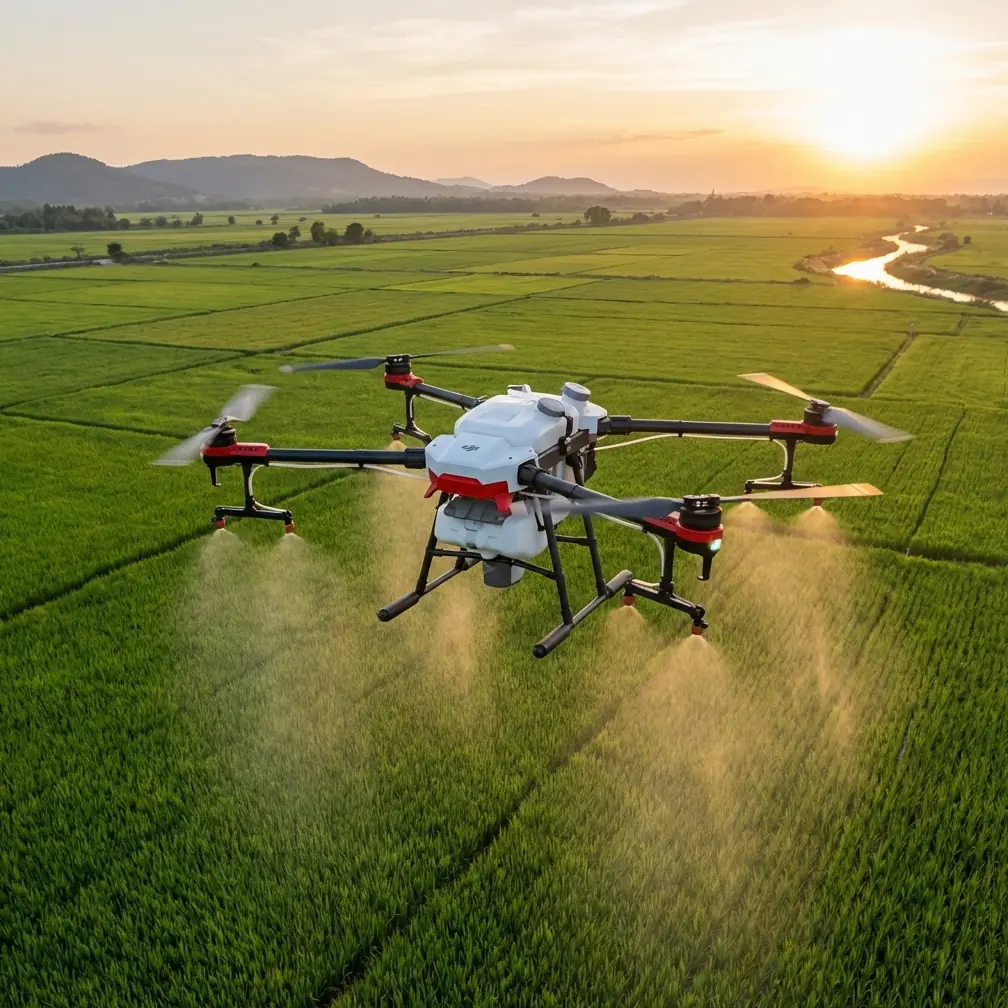
Spraying steep, broken, or irregular ground with an Agras T50 is not the same job as covering a flat, open rice block. Terrain changes airflow. Crop height shifts from row to row. Valleys and ridgelines distort your effective spray height even when the aircraft thinks it is holding a stable path. If you treat complex ground like a uniform field, the result is familiar: patchy deposition, overspray on upper contours, underdosing in dips, and more drift than the operator expected.
The real skill is not simply flying lower or slower. It is understanding how the T50’s flight height interacts with swath width, droplet behavior, nozzle output, and positioning stability. That is where experienced operators separate clean application from expensive inconsistency.
I want to frame this around one practical question: what is the optimal flight altitude for spraying fields in complex terrain with an Agras T50?
The short answer is that there is no single universal number. The useful answer is this: for complex terrain, the best altitude is usually the lowest height that still preserves a stable spray pattern, safe terrain clearance, and consistent overlap as the aircraft moves over changing elevation. In practice, operators often get better results by targeting a conservative height above canopy rather than above takeoff point, then adjusting speed and flow to hold deposition quality instead of forcing a wide swath.
That distinction matters.
Why altitude matters more on complex terrain
On flat land, flight altitude mainly changes two things: how wide the swath becomes and how long droplets stay exposed to wind before reaching the target. On complex terrain, altitude also determines whether the aircraft is actually applying at the same effective distance from the crop throughout the route.
If the drone flies what looks like a fixed line but the ground rises beneath it, the nozzles may end up too close to the canopy on upper sections. Coverage can become overly concentrated. Rotor wash can disturb leaves more aggressively. In the next section, where the ground drops away, the opposite happens. The spray cloud has farther to travel, drift risk increases, and the edge of the swath can thin out before droplets settle into the crop.
This is why terrain-following behavior and positioning confidence are not secondary features. They are central to spray quality.
The Agras T50 is often chosen for demanding agricultural work because operators need repeatability, not just payload. In uneven fields, repeatability depends heavily on how consistently the aircraft can maintain its intended relationship to the crop surface. That is where centimeter precision and a strong RTK fix rate become operationally meaningful rather than marketing language. If your positional solution is stable, the aircraft can hold lines and turns with less lateral error, preserve overlap more effectively, and reduce the chance that terrain transitions create untreated strips or doubled application zones.
Start with canopy-relative height, not a generic number
For complex terrain, the wrong habit is setting a one-size-fits-all altitude before understanding the field profile. The right habit is defining height relative to crop canopy and terrain shape.
Think in three layers:
- Canopy height
- Terrain variability across the route
- Weather-driven drift risk
If your field includes terraces, rolling slopes, embankments, or irregular drainage cuts, your altitude target should be built around the tallest and most exposed sections first. Why? Because the most elevated points are where an overly low flight path can compress the spray pattern and create uneven deposition, while the low sections tempt operators to compensate by flying higher overall, which increases drift.
A better approach is to map or visually inspect the field and divide it into terrain behavior zones. Not different crops, necessarily—different height-control challenges. A steep shoulder, a bowl-shaped depression, and a contour edge should not be treated as identical just because they are in the same field.
If you have access to multispectral field data from separate scouting workflows, that can help identify vigor differences and canopy density changes that influence how aggressively droplets penetrate. Multispectral imagery does not set spray height by itself, but it can tell you where a dense, healthy canopy may justify tighter deposition control and where sparse coverage could tolerate a different droplet strategy. That is useful in complex ground because terrain and crop structure often compound each other.
The practical altitude rule for difficult fields
When operators ask me for a field-ready rule, I give them this:
Use the lowest stable canopy-relative altitude that maintains an even swath and avoids rotor-induced disturbance, then validate that setting on the highest and lowest terrain sections before committing to the whole block.
That is not vague. It is operational.
The test matters because your ideal setting on the central slope may fail at the ridge or drainage edge. You should be looking for three signs during the trial pass:
- Is the swath width holding consistently?
- Is the crop receiving even deposition across the pass?
- Is visible drift increasing when the terrain drops away beneath the aircraft?
If the answer to the third question is yes, your effective spray height in those lower sections is probably too high, even if the mission settings appear reasonable.
Swath width is useful only if it is repeatable
Many operators focus on maximizing swath width. On complex terrain, that can become a trap.
A wider swath looks efficient on paper, but if your altitude varies relative to the crop, the outer edges of that swath are the first place application quality degrades. In practical agronomy, a narrower but repeatable swath usually beats an optimistic wide pass with inconsistent edge deposition.
The Agras T50 has the output capability to tempt operators into covering demanding fields quickly. Speed and capacity are valuable, but on irregular ground the priority should be overlap integrity. If you stretch width too far, terrain variation magnifies the weakness. Your centerline may still look fine while the margins are under-applied.
This is also where RTK performance enters the real spraying conversation. A high RTK fix rate supports better line holding and more reliable overlap, especially on sloped or segmented routes where every pass transition matters. If the aircraft is wandering laterally even slightly while the terrain changes vertically beneath it, your actual application pattern can become far less uniform than the flight log suggests.
Nozzle calibration decides whether your altitude strategy works
Altitude alone cannot rescue poor nozzle setup.
Nozzle calibration is one of the most neglected variables in difficult terrain, because operators often assume that if the drone is flying correctly, the application must be correct. But once terrain begins changing your effective spray height, any mismatch in nozzle output or droplet uniformity becomes more visible in the crop.
Here is the sequence I recommend before a complex-terrain mission:
- Confirm actual nozzle output, not assumed output
- Inspect for wear, partial blockage, and uneven atomization
- Match flow settings to intended speed and target deposition
- Recheck after any nozzle swap or chemical formulation change
The operational significance is simple. If one nozzle is delivering a slightly different pattern, that inconsistency gets exaggerated when the aircraft transitions from ridge to hollow. What might have been a tolerable deviation on flat land becomes visible striping or uneven efficacy.
In difficult fields, nozzle calibration is not maintenance trivia. It is part of your terrain strategy.
Spray drift gets worse when terrain fools the operator
Spray drift in complex terrain is often misdiagnosed as a weather-only problem. Wind matters, of course, but terrain can create a false sense of security. The aircraft may be following the planned route perfectly while the crop below drops away, increasing droplet travel distance and exposure time. To the operator, nothing looks wrong unless they are actively judging canopy-relative height.
That is why the optimal altitude for these fields is usually lower than the setting inexperienced operators choose after seeing a few terrain obstacles. They add extra margin “for safety,” but that margin often converts directly into drift and weaker deposition on lower ground.
A better way to build safety into the mission is not simply adding height. It is combining moderate altitude with careful route planning, conservative speed, and close observation of downwind behavior during test passes.
If drift sensitivity is high, reduce ambition. Tighten the swath. Lower speed. Keep the aircraft closer to the crop where safe. Precision is usually cheaper than rework.
Weatherproofing and washdown are not minor details
The T50’s IPX6K rating is especially relevant for operators working in rough agricultural conditions. On paper, that looks like a durability spec. In daily operation, it supports a more disciplined spraying workflow.
Complex terrain often means more dust on launch points, more mud, more splashing around irrigation channels, and more residue accumulation after repeated missions. A platform with IPX6K-level protection is easier to maintain to a consistent standard between jobs, which helps preserve sensor reliability, wiring integrity, and cleaning discipline. That matters because terrain-following quality and stable agricultural operation depend on the aircraft staying in good condition, not merely surviving the day.
In other words, environmental protection influences application consistency indirectly. Dirty or poorly maintained equipment is less predictable, and unpredictability is the enemy of accurate spraying on uneven ground.
A field method that works
For operators spraying hilly orchards, terraced plots, or mixed-elevation row crops, I recommend this workflow:
1. Walk or scout the field first
Identify the highest canopy points, the sharpest elevation transitions, and any sections where wind channels through gaps or contours.
2. Build zones, not just one mission mindset
Separate the field into areas where the aircraft can maintain similar canopy-relative height. This reduces the temptation to compromise the whole mission around one awkward section.
3. Start conservative
Use a moderate speed and a realistic swath width. The first objective is even deposition, not maximum hectares per hour.
4. Validate on contrasting terrain
Test your chosen altitude on both a high contour and a lower depression. If the lower section shows more drift or weaker coverage, adjust before scaling up.
5. Watch overlap, not just center coverage
A pass can look acceptable in the middle and still fail at the edges. Repeatability across adjacent passes is the real quality marker.
6. Recheck nozzle performance
If coverage shifts unexpectedly, do not assume the problem is only altitude. Confirm calibration and spray pattern consistency.
7. Protect your positioning quality
Centimeter precision is only useful when your RTK conditions are solid enough to sustain it through the mission. On segmented, irregular fields, line repeatability directly affects treatment uniformity.
If you want a second set of eyes on terrain-based setup choices, field operators often find it useful to message our Agras support team on WhatsApp before running a difficult block.
What the broader UAV industry gets right—and wrong—about “integrated solutions”
A recent drone industry development offers a useful contrast. On 2026-04-08, DroneLife reported that South Korean eVTOL developer Airbility entered a four-party Memorandum of Understanding with Thailand’s NT iBuzz, SmartOkO Thailand, and Singapore-based KILSA Global to deploy integrated UAV systems in Thailand. The article described the effort as an integrated UAV public safety solution involving four organizations.
Why mention that in an Agras T50 spraying discussion? Because the structure of the partnership highlights a truth agricultural operators already know: UAV performance in the field rarely depends on the aircraft alone. Integration matters.
In agriculture, the integrated system is different. It is not about public safety applications. It is about how the airframe, RTK reliability, nozzle calibration, terrain logic, field scouting data, and maintenance discipline work together. The Airbility example shows the industry moving toward multi-party, system-level deployment models. For farm operators, the lesson is practical: stop thinking of spray results as a single-spec problem.
A strong aircraft can still produce weak agronomic outcomes if the setup chain is fragmented. By contrast, when route planning, precision positioning, and application hardware are aligned, the T50 becomes far more effective in the exact conditions that challenge lesser workflows: steep sections, irregular elevations, and fragmented blocks.
That is the real story behind spraying complex terrain successfully. It is not about chasing one magic altitude. It is about using altitude as one controlled variable inside a complete operating method.
The takeaway for Agras T50 operators
If you are spraying complex terrain, your optimal flight altitude is the lowest safe and stable height above canopy that preserves a reliable spray pattern and limits drift across changing elevation. Do not choose that height in isolation. Tie it to nozzle calibration, overlap discipline, RTK stability, and realistic swath expectations.
Two details matter especially here.
First, centimeter-level positioning and RTK fix quality are not abstract precision benefits. They directly support pass-to-pass consistency on irregular ground, where small line errors become visible agronomic problems.
Second, the T50’s IPX6K protection is more than a ruggedness badge. It supports maintenance consistency in dirty, wet agricultural environments, which helps keep the aircraft dependable when terrain-following and application repeatability matter most.
Complex fields punish lazy assumptions. They reward operators who test, calibrate, and adjust.
Ready for your own Agras T50? Contact our team for expert consultation.