Agras T50 for Wildlife Work in Extreme Temperatures
Agras T50 for Wildlife Work in Extreme Temperatures: A Field Consultant’s Take
META: A practical expert guide to using the Agras T50 around wildlife operations in extreme temperatures, with insight on image discipline, spray control, RTK precision, and why training matters more than spec sheets.
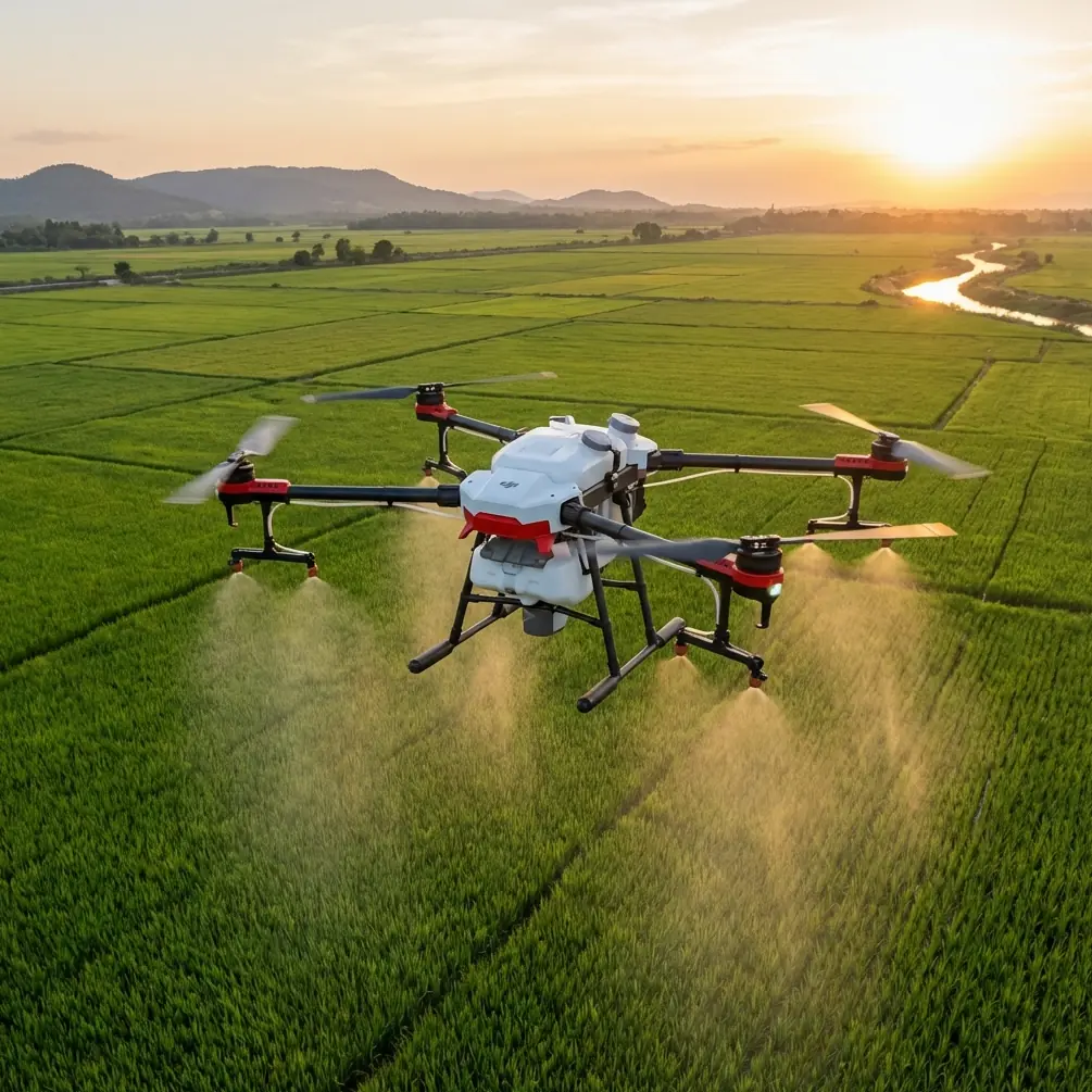
When people talk about the DJI Agras T50, they usually start with agriculture. Fair enough. That is the machine’s home territory. But that narrow framing misses something useful for field teams working near wildlife habitats, remote conservation zones, and temperature-stressed landscapes. In those environments, the T50 is not just a spraying platform. It becomes a disciplined aerial tool for coverage, repeatability, and observation support—if the operator understands where technical performance ends and field judgment begins.
That distinction matters most in extreme temperatures.
I have seen teams assume that a bigger, more capable airframe will automatically solve difficult wildlife-related field tasks. It will not. Heat shimmer, cold-soaked batteries, inconsistent visibility, drifting droplets, and rushed decision-making can undermine even a strong platform. What separates a productive T50 operation from a wasteful one is not simply hardware. It is the combination of aircraft capability and a systemized way of seeing, interpreting, and acting.
That second part may sound unusual in an article about the Agras T50, but it is exactly where many operations fail.
A recent Chinese photography training article made a point that translates surprisingly well to drone fieldwork: strong image-making is both technical practice and aesthetic interpretation, and progress comes from moving beyond simple “viewing” into active “reading” of what you see. The piece recommends analyzing 3 to 5 images per day, breaking down composition, light-shadow relationships, and emotional meaning, then building a visual notes library. For Agras T50 teams scouting wildlife in extreme temperatures, that is not artistic fluff. It is operationally relevant.
Because in wildlife-adjacent drone work, the real bottleneck is often interpretation.
The real problem in wildlife scouting is not always flight time
On paper, operators tend to focus on familiar metrics: swath width, nozzle calibration, RTK fix rate, centimeter precision, weather resilience, and workload per sortie. Those are important. They should be. If you are managing vegetation treatment near habitat boundaries, monitoring inaccessible corridors, or working around water and brush under punishing heat or cold, you need an aircraft that can maintain stable, repeatable passes and dependable positional accuracy.
That is where the Agras T50 tends to stand apart from weaker platforms in its class. Compared with lighter or less field-hardened competitors, the T50 is generally the better fit when the mission includes heavy-duty commercial work under rough environmental conditions. The reason is not one flashy feature. It is the combination: robust agricultural design language, high-throughput mission capability, and the kind of precision workflow that matters when small errors become ecological problems.
Consider spray drift. In wildlife-sensitive areas, drift is not a minor performance issue. It is a boundary-control problem. If treatment intended for invasive growth or corridor management moves beyond the target zone, you are no longer dealing with efficiency loss alone. You are dealing with habitat contamination risk, non-target exposure, and poor stewardship. A T50 operator who understands nozzle calibration, droplet behavior, wind interaction, and route geometry has an advantage over operators flying aircraft that are less stable or less purpose-built for precise application work.
The same applies to RTK fix rate and centimeter precision. Those phrases get thrown around casually, but their practical significance is simple: when wildlife teams need repeatable route alignment in difficult terrain, precise positioning reduces overlap errors, missed strips, and accidental encroachment into exclusion zones. In an extreme-temperature mission, where battery strategy and time on station are already constrained, repeatability is not just a nice technical detail. It is operational insurance.
Why extreme temperatures expose weak workflows
Heat and cold punish inconsistency.
In very hot conditions, visual interpretation gets harder long before the aircraft reaches its technical limits. Contrast can flatten. Dust and glare can obscure fine detail. Vegetation signatures can appear deceptively uniform. Animal movement patterns may shift to shaded edges, drainage lines, or thermal refuges that are easy to miss if an operator is merely scanning rather than interpreting.
In very cold conditions, the problem changes shape. Shadows sharpen. Surface textures may become more legible, but battery behavior, handling tempo, and reaction times can degrade. Operators tend to rush because the environment is uncomfortable. That is when route discipline slips, image review gets skipped, and the team starts trusting assumptions over evidence.
This is exactly why the photography reference is so relevant. It argues that progress requires a systematic, measurable training framework, not random repetition. For a T50 wildlife-support workflow, that translates into something practical:
- reviewing mission imagery with intent rather than just archiving it,
- documenting what specific light conditions did to visibility,
- comparing how target areas looked at different times of day,
- building an internal notes library of recurring visual patterns,
- teaching operators to explain what they are seeing, not just point at it.
That shift from “looking” to “reading” the scene is where field performance improves.
The Agras T50 is strongest when paired with visual discipline
The T50’s advantage over many competitors is that it gives professional operators a stable, repeatable platform for serious fieldwork. But repeatability only creates value if the team also improves its ability to interpret environmental cues.
For example, if you are scouting wildlife movement adjacent to managed agricultural land, the aircraft’s precision and route consistency can help you map where intervention should stop and observation should begin. That boundary is rarely obvious in extreme weather. In heat, signs of stress in vegetation or soil may mimic broader habitat disturbance. In cold, compressed movement corridors can appear more active than they really are. A team with strong visual interpretation habits is less likely to misread those signals.
This is where multispectral thinking also enters the conversation, even if the T50 itself is not always deployed as the primary multispectral platform. In mixed drone fleets, the T50 often performs best as the workhorse component inside a larger decision system. One aircraft may gather analytical imagery. The T50 may execute treatment, distribution, or structured route operations based on that analysis. If you understand this division of labor, the T50 becomes more effective. If you expect it to do every job equally well, you create blind spots.
That is another area where some competing models fall short. They may advertise versatility, but under real field conditions, especially in extreme temperatures, versatility without workflow clarity becomes confusion. The T50 rewards crews who define roles clearly: identify, verify, execute, review.
A better way to train T50 crews for wildlife-adjacent missions
Most drone training is too shallow. Pilots learn controls, mission planning basics, a few safety rules, and perhaps some maintenance routines. Then they go to the field and discover that the difficult part is not flying. It is judgment.
The photography source emphasizes that photography is both knowledge and worldview. That may sound philosophical, but the operational takeaway is concrete: what the operator notices depends on what the operator has trained themselves to recognize. In drone work near wildlife habitats, this means a T50 team should build a visual training routine around real mission outcomes.
A strong framework looks like this:
1. Analyze a small set of field images every day
The reference recommends 3 to 5 master images daily. Adapt that method. Pull 3 to 5 frames or map extracts from prior T50 missions and ask:
- What does the light hide?
- What does the light reveal?
- Where could drift have gone unnoticed?
- Which route segment created ambiguity?
- Did surface texture affect interpretation?
The point is not volume. It is consistency.
2. Build a visual notes library
The source specifically recommends creating a visual note archive. For T50 teams, this is one of the highest-return habits you can adopt. Tag images by temperature condition, wind profile, habitat edge, nozzle setup, and mission outcome. Over time, your team stops guessing. You develop a searchable memory.
3. Separate observation from execution
Do not let the same rushed mental model govern both scouting and application decisions. The T50 can execute disciplined missions, but the team must first confirm what they are seeing. This is especially critical when environmental stress changes how terrain and cover appear from the air.
4. Review nozzle calibration as part of habitat protection
Nozzle calibration is often treated as a maintenance checkbox. In wildlife-sensitive operations, it is a biological boundary tool. Correct calibration supports droplet consistency and helps reduce unwanted spread beyond the target area. That matters far more than many teams realize.
5. Track RTK reliability, not just route completion
A route completed with poor positional confidence can still create avoidable errors. Monitoring RTK fix behavior and understanding when centimeter-level consistency is truly available is central to repeatable corridor work.
Why IP-rated resilience matters more in the field than in brochures
When crews work around mud, dust, residue, temperature swings, and repeated cleaning cycles, ingress protection stops being a spec-sheet brag and becomes a maintenance reality. A field platform associated with IPX6K-level resilience speaks to survivability under harsh wash-down and contaminated operating conditions. For wildlife-adjacent commercial work, that reduces downtime and protects consistency.
That does not mean you ignore environmental limits. It means the platform is better suited to real deployment cycles than consumer-oriented alternatives that look capable until the environment turns against them.
And that is the recurring story with the Agras T50. It is not superior because it is dramatic. It is superior because it stays useful when the mission is messy.
The best T50 operations are built, not bought
If you are evaluating the Agras T50 for wildlife scouting support in extreme temperatures, resist the temptation to shop by isolated features alone. Swath width matters. So does nozzle calibration. So does RTK stability. So does environmental sealing. But those things only deliver full value inside a disciplined operational method.
The photography reference offers an unexpectedly sharp lesson for T50 operators: moving from simple recording to real creation requires a systematic, quantifiable training system. In drone terms, moving from “we flew the mission” to “we produced reliable field intelligence and controlled execution” requires the same mindset.
That is the difference between collecting aerial data and understanding it.
That is also why the T50 often outperforms less serious alternatives in these scenarios. Not because it removes complexity, but because it gives competent teams a more dependable platform on which to manage that complexity.
If your operation includes habitat edges, invasive vegetation control, difficult weather windows, or repeated missions where positional consistency matters, the T50 deserves a hard look. Just do not treat it like magic. Treat it like a professional system that rewards professional habits.
If you want to discuss mission planning details, environmental workflow design, or field setup choices for this platform, you can reach out here via direct WhatsApp field support.
The smartest T50 teams I know all share one trait: they train their eyes as seriously as they train their aircraft.
Ready for your own Agras T50? Contact our team for expert consultation.