Scouting Vineyards in Complex Terrain with the Agras T50
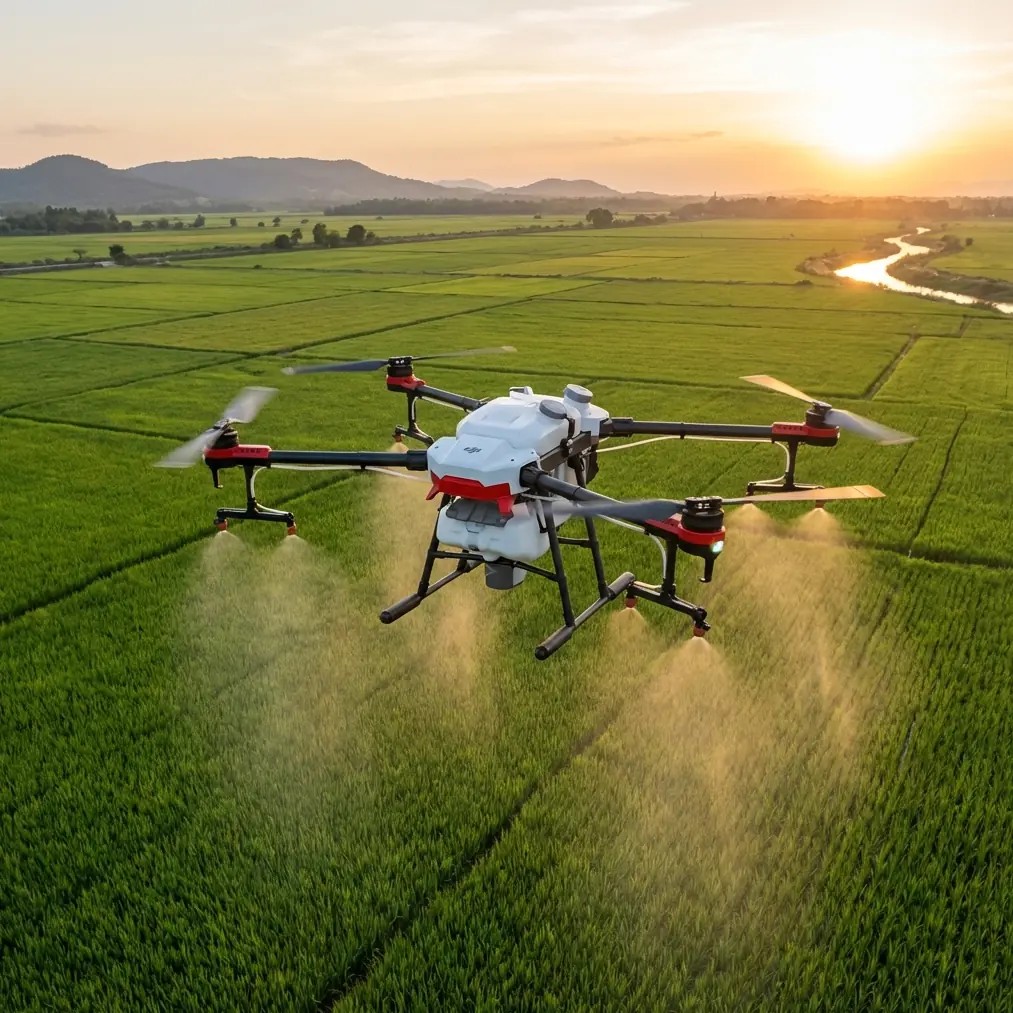
Scouting Vineyards in Complex Terrain with the Agras T50: What Actually Matters in the Field
META: A field-focused look at using the DJI Agras T50 for vineyard scouting in complex terrain, with practical insight on precision flight paths, sensor awareness, spray drift control, and canopy-level observation.
Vineyard scouting sounds simple until the terrain stops cooperating.
Flat demo plots make every drone look competent. Hillsides, broken rows, wind funnels, irrigation hardware, and mixed canopy vigor are where a platform starts to reveal its real value. For growers and vineyard managers evaluating the Agras T50, the question is not whether it can fly over vines. The question is whether it can produce repeatable, useful observations in terrain that changes by the meter.
That is where scouting becomes less about headline specs and more about how the aircraft moves, how precisely it holds a path, how safely it handles unexpected obstacles, and how well an operator can build a workflow around it.
The T50 is usually discussed for application work, but in vineyard operations its value begins earlier. Before any tank is filled, before nozzle calibration, before swath width is finalized for a treatment block, the aircraft can serve as a fast decision tool. In complex terrain, that role matters even more because variation is the rule, not the exception.
The vineyard problem: complexity hides in the curves
Vineyards rarely fail uniformly. You do not usually get a neat square of obvious stress. What you get are edge effects near access roads, thin growth on exposed slopes, moisture differences at lower elevations, and subtle canopy shifts near terraces or drainage channels. Scouting on foot catches some of it. It also burns time and often misses spatial patterns.
The challenge intensifies in irregular blocks. Curved headlands, contour-planted rows, and elevation changes complicate coverage. A drone used for scouting has to do more than get airborne. It needs to travel in a way that preserves visual consistency and positional trust.
That is why path discipline matters.
One of the most useful reference points here comes from a flight-training document describing coordinate-based arc flight. In that example, a drone builds a curved route from three spatial points: a default starting point at (0,0,0), a midpoint (x1,y1,z1), and an endpoint (x2,y2,z2). The same source notes that the resulting arc radius must remain within 50 to 1000 centimeters, and gives a sample circular route using points such as (100,100,0) and (100,-100,0) at 50 centimeters per second, while keeping the aircraft’s heading unchanged.
That is not an Agras T50 feature sheet. It is something more useful: a reminder of how controlled arc movement changes what the operator sees.
In vineyards, straight lines are not always the best scouting lines. When rows bend around terrain, a machine that can maintain smooth, predictable travel through curves gives the camera and onboard sensing systems a better chance to collect usable imagery. Jerky corrections and uneven yaw shifts can turn a scouting flight into a stack of compromised observations. Smooth arc logic, stable heading, and centimeter precision are not academic ideas. They are what separate “I flew the block” from “I can trust what I saw.”
Why curved flight behavior matters for canopy reading
A vineyard manager looking at canopy density, missing vines, early disease pressure, or irrigation inconsistency needs clean visual context. If the aircraft swings its nose unpredictably through every contour, image interpretation becomes harder. Shadows change. Row orientation shifts in frame. Small anomalies become less obvious.
The training reference mentioned above highlights one subtle but operationally significant point: the drone’s orientation remains unchanged during the circular route. For vineyard scouting, that kind of stable orientation can matter as much as positional accuracy. Consistent framing helps the operator compare one part of a row with another without mentally correcting for constant angle changes.
This becomes even more relevant if the T50 is used alongside external analysis workflows, whether visual review, map-based notes, or comparisons with multispectral datasets collected elsewhere in the operation. Even when the T50 is not the dedicated multispectral platform, scouting flights often inform where a more detailed scan should happen next. A stable route helps make that handoff cleaner.
Complex terrain is where RTK trust is earned
People throw around “centimeter precision” casually. In vineyards, it should not be treated as a slogan.
On a slope, a few feet of uncertainty can mean the difference between checking the correct terrace lane and misreading a stress zone entirely. In scouting mode, strong RTK fix rate matters because it allows observations to be tied back to exact places in the block. That helps crews return to the right rows for leaf inspection, irrigation checks, or later application.
This is where the T50’s practical value comes into focus. A platform built for serious agricultural work is expected to operate with disciplined positioning, not just broad-area coverage. In vineyards with elevation changes and fragmented geometry, that positional confidence saves labor twice: once in the air, then again on the ground when crews need to verify what was found.
And accuracy does not only support scouting. It feeds directly into later decisions about spray drift exposure, nozzle calibration strategy, and swath width adjustment.
If a scouting pass identifies a block edge where crosswinds consistently accelerate through a gap in the terrain, that should shape the treatment plan. If canopy density changes sharply halfway up a slope, that may justify a different application approach or timing. Good scouting is not separate from spraying. It is what makes spraying more precise and less wasteful.
A drone that sees the vineyard as it really is
One detail often overlooked during equipment evaluation is how the aircraft behaves around non-crop surprises. Vineyards are active environments. Workers move between rows. Dogs show up. Deer jump fences. Birds burst out of cover crops with little warning.
On one hillside scouting run, the most telling moment was not a map output. It was a red fox moving between two lower rows just after sunrise. The aircraft’s sensing system registered the movement early enough for the operator to hold a safe stand-off and adjust the route without losing the section being inspected. That kind of encounter sounds anecdotal until you spend enough time in the field to realize how often the unexpected shares the block with your flight plan.
Sensor performance matters most when the environment stops behaving like a test field. In real vineyard scouting, obstacle awareness is not only about trunks, poles, and trellis infrastructure. It is also about preserving safe, uninterrupted operations when wildlife or people enter the scene.
For operators in complex terrain, that translates to less guesswork and fewer conservative aborts. The safer the aircraft is at reading the environment, the more consistently it can finish the scouting mission you actually need.
Weather, washdown, and the reality of farm use
Vineyard equipment does not live in a lab. Dust, mist, mud, chemical residue, and sudden weather shifts are part of the operating context.
That is why ruggedization is not a cosmetic feature. If you are scouting in the morning, calibrating nozzles later, and moving between blocks with different road conditions, durability affects uptime. An IPX6K-class protection rating matters because agricultural workflows are messy. Equipment that tolerates water exposure and routine cleaning fits farm reality better than delicate systems that require operators to treat every field day like a museum visit.
For a scouting workflow, this means less hesitation about flying in the narrow windows that agriculture often forces on you. It also means the aircraft can transition more naturally between inspection and application-related tasks without turning maintenance into a bottleneck.
Scouting before spraying: where the T50 earns more than one role
The strongest case for using the T50 in vineyards is not that it can do everything. It is that it helps connect stages of work that are too often handled in isolation.
A scouting flight can reveal where canopy is open enough to invite drift risk. It can show where row spacing and vine volume support one swath width, and where a narrower pattern may be wiser. It can help identify portions of the block where nozzle calibration deserves extra scrutiny because canopy load or slope exposure changes the deposition environment.
This is especially valuable in vineyards because drift is rarely just a compliance concern. It is a crop quality issue, a neighbor issue, and a margin issue. Terrain amplifies drift unpredictably. Saddles, terraces, and edge rows can create airflow behavior that looks minor from the ground and obvious from above.
That is why good operators do not separate scouting from application planning. They use scouting to build a more intelligent application map in their heads before they ever run product.
Simple visual principles still matter from the air
One of the supplied photography references, although not written for agricultural drones, contains a point that translates surprisingly well to vineyard scouting: when photographing a single flower, placing it in the center of the frame creates a clear visual focal point and helps reveal fine detail, including the flower core. The same article emphasizes that effective composition depends on keeping the frame simple and making the subject stand out.
That principle applies in aerial scouting more than many operators realize.
When you are checking a suspect vine section, a damaged post, a missed row, or a visible disease hotspot, the cleanest image is often the most useful image. Not every scouting pass should aim for broad cinematic coverage. Sometimes the better move is to center the target, reduce clutter, and capture details with visual discipline.
The connection here is practical. Vineyard scouting is not only about collecting more data. It is about collecting interpretable data. A cluttered frame wastes time. A clear focal subject speeds decisions.
This matters when teams are reviewing images quickly between tasks. If the T50 is being used to document a specific row issue for later follow-up, framing the subject cleanly can make the difference between actionable evidence and one more ambiguous photo in a folder nobody revisits.
What this means for a vineyard operator evaluating the T50
If you are scouting vineyards in complex terrain, the Agras T50 should be judged on field logic, not brochure logic.
Can it hold a path that matches curved vineyard geometry without introducing visual inconsistency? That is where the coordinate-arc concept becomes relevant. A reference example using a 100-centimeter radius route and 50 centimeters per second speed shows how smooth curvature and steady orientation support controlled observation. In vineyard terms, that means better continuity along contour-shaped rows.
Can it help you trust location enough to act on what you see? That is where RTK fix rate and centimeter precision stop being buzzwords and start saving labor.
Can it handle the untidy reality of farm environments, including washdown conditions and unexpected movement in the block? That is where sensor awareness and IPX6K-level durability become operational, not decorative.
Can it connect scouting to better application decisions? That is where the platform becomes more than a flying observer. It becomes part of a precision workflow that can reduce drift exposure, improve nozzle decision-making, and tighten treatment planning across variable terrain.
For growers, consultants, and managers who want to compare workflows or talk through a block-specific setup, this is the most direct way to continue the conversation: message a vineyard drone specialist here.
The real takeaway
The Agras T50 makes the most sense in vineyards when it is treated as a decision platform first and an application platform second.
That may sound backward, but in complex terrain it is the right order. First understand the block. Then act on it.
A scouting mission that follows terrain intelligently, maintains stable observation angles, records precise locations, and safely navigates the living unpredictability of a vineyard gives the operator something valuable: confidence. Confidence in what was seen, confidence in where it was seen, and confidence that the next operational step is based on reality rather than assumption.
That is the difference between flying a vineyard and actually reading one.
Ready for your own Agras T50? Contact our team for expert consultation.