Agras T50 Field Report: What High-Altitude Vineyard
Agras T50 Field Report: What High-Altitude Vineyard Scouting Really Demands
META: A field-based Agras T50 analysis for high-altitude vineyard scouting, covering route planning, interference checks, crew discipline, battery heat risk, and why mapping-grade habits matter in agricultural operations.
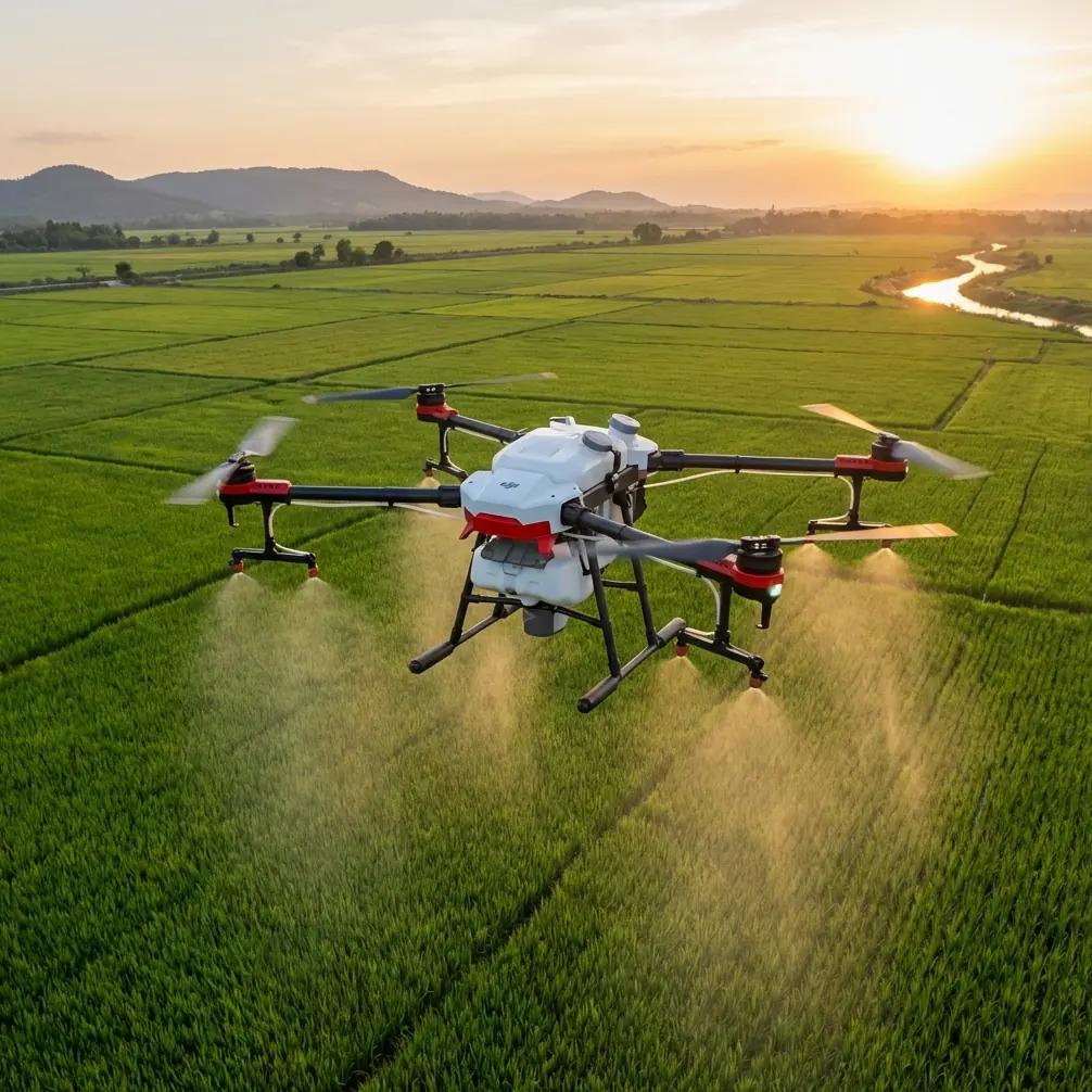
High-altitude vineyards punish sloppy drone operations.
That is the first thing I tell growers who assume an aircraft like the Agras T50 can be judged only by tank size, spray output, or brochure specs. In mountain viticulture, the real separator is not raw capacity. It is whether the crew can turn a complex slope, fragmented canopy, crosswind exposure, and signal uncertainty into a repeatable mission. The reference materials behind this report make that point clearly, even though they come from two different directions: one from agricultural flight discipline, the other from UAV remote sensing used in water-management monitoring.
Put those two together and a sharper picture of the T50 emerges.
This is not just a spraying platform. In the hands of a disciplined crew, it becomes a decision tool for scouting vineyards where altitude, terrain, and access work against you.
The T50 is only as good as the pre-flight thinking around it
The agricultural operating standard in the source material is blunt: before any task, the crew should study the site, observe terrain and crops, and work with the lead operator to define flight speed, flight method, route, and altitude. That sounds routine until you apply it to a high-altitude vineyard.
A vineyard on steep ground is rarely uniform. Row orientation shifts. Wind channels through gaps. Terraces create abrupt elevation changes. Some blocks have exposed edges, while others are shielded by treelines or rock faces. If you scout these areas with a generic plan, your data becomes inconsistent, and your later spray decisions can drift off target.
With the Agras T50, scouting should start the same way a careful spray mission starts: by building a block-specific plan rather than trusting one template across the property. In practical terms, that means identifying where the aircraft can maintain stable height over the canopy, where swath width will narrow because of slope geometry, and where nozzle calibration later needs to be adjusted because the aircraft flew over uneven vine vigor zones during observation.
The operational significance is simple. When the crew plans speed, route, and altitude around the actual vineyard instead of the map in their head, the T50 produces scouting passes that are useful for action. Not just pretty imagery. Actionable observations.
Why interference checks matter more in mountain vineyards than most operators admit
One detail from the flight operations document deserves more attention than it usually gets: once on site, the crew is expected to inspect takeoff and landing zones, travel paths, obstacles, and possible signal or magnetic interference, then conduct a range test to confirm a clean flight environment.
That language is practical, not academic.
In a high-altitude vineyard, interference is rarely obvious from the road. A ridgeline can interrupt communications. A pump station, buried power infrastructure, fence wiring, or a metal-roofed outbuilding can distort assumptions about the safest launch point. Even a good RTK Fix rate can become less meaningful if the physical launch area creates weak habits from the start.
This matters for scouting because the value of the T50 depends on positional consistency. If you are evaluating stress pockets, checking drift-prone zones near block edges, or comparing one pass against another over time, centimeter precision is not a luxury. It is the difference between seeing a pattern and chasing noise.
The remote sensing reference reinforces this from another angle. In the water-monitoring case, UAV data was processed into geo-referenced mosaic outputs with enough reliability to support change analysis over time. The study compared imagery from 2010 to 2014 and showed that a river segment gradually shifted from north to south over a four-year period. That is the kind of temporal comparison that only works when the underlying location data is trustworthy.
For vineyard scouting, the lesson is direct. If you want to compare canopy stress, drainage effects, disease pressure, or edge-row exposure across multiple flights, you need the same level of positional discipline. A T50 can contribute to that workflow, but only if the crew treats interference testing, route verification, and launch-area selection as non-negotiable.
The strongest scouting teams think like survey crews
One reason the water-monitoring material is useful here is that it shows how serious UAV operators extract meaning from more than just a flight. In that case, the mission was not limited to river imagery. It also examined adjacent infrastructure, nearby buildings, exposed mudflats, farmland around the river margin, and overhead transmission lines that could indicate safety concerns.
One measured detail stands out: a building near the river was identified at a distance of 76.9 m from the channel, and that distance was evaluated against river management rules. Another: a bridge in the monitored area was recorded at 109.24 m in length, with associated infrastructure visible from the imagery.
Why mention that in an Agras T50 article for vineyards?
Because it highlights the mindset high-altitude growers need. Scouting is not merely “fly and look.” It is measure, compare, and interpret. A vineyard block does not exist in isolation. Access roads, retaining walls, irrigation lines, drainage cuts, utility crossings, and worker approach paths all shape how the T50 should later operate for application work.
A serious scouting mission with the T50 should document more than the vines:
- exposed edge rows where spray drift risk rises,
- service roads that can act as safe staging corridors,
- overhead lines that constrain approach angles,
- erosion channels that hint at future traction or runoff problems,
- structures too close to active flight lanes,
- and areas where row gaps or irregular planting will affect spray consistency.
This is where a third-party accessory can genuinely expand capability. On several mountain vineyard projects, I have seen operators improve planning quality by pairing the aircraft workflow with a third-party RTK base solution and terrain-aware mission planning toolkit. Not because the T50 is incapable on its own, but because altitude change and fragmented topography demand tighter repeatability. If your vineyard blocks are broken into terraces or interrupted by access cuts, that accessory layer can improve alignment between scouting observations and later task execution.
Done right, the T50 stops being a single-mission machine and becomes part of a site intelligence system.
Battery discipline is not a side note at altitude
The source document includes a warning many crews skim past: batteries must not be used or stored in high-heat environments such as strong sun or a hot vehicle, because overheating can lead to fire risk, performance degradation, and shorter service life.
For high-altitude vineyards, that matters in a very specific way.
Operators often assume cooler mountain air offsets battery stress. But vineyard work typically involves exposed staging areas, reflective surfaces, and long periods of setup in direct sun. A battery sitting in a parked vehicle or on bare ground beside a rock wall can heat up fast, even when ambient conditions feel manageable. Then the crew wonders why performance consistency slips from one sortie to the next.
On a T50, battery management directly affects mission rhythm. If your scouting session is designed to compare multiple vineyard blocks in a short time window, degraded battery behavior can distort the dataset. You may change flight speed, abort sections, or alter altitude margins simply because the power system is no longer behaving predictably.
Operationally, the takeaway is clear: battery temperature control is part of data quality control. Not just a safety box to tick.
Crowd control, crew spacing, and observation roles are part of scouting quality
The agricultural procedure also requires crew PPE, including helmets and workwear, and instructs the team to keep onlookers at a safe distance. It goes further, outlining how support personnel should assist the pilot with range testing, performance checks, environmental observation during flight, and flight log completion.
That division of labor is exactly what high-altitude vineyard scouting needs.
These sites attract interruptions. Owners walk up mid-mission. Labor crews cross routes. Visitors stop to watch. Vehicles appear where they should not. If the pilot has to manage flight controls, obstacle awareness, bystander communication, and mission annotation at the same time, scouting quality drops immediately.
A good T50 field team uses a second set of eyes. While the pilot maintains aircraft attitude and route consistency, the assistant watches the environment, confirms line clearance, monitors changing wind behavior, and logs what the camera or observation pass is actually revealing. That log matters later. The source specifically mentions recording flight count, flight time, real-time battery condition, and work area. In a vineyard context, I would add block ID, elevation band, wind notes, and any visual signs tied to disease, weak vigor, or irrigation irregularity.
You do not build a useful scouting record from memory at the truck.
Spray drift decisions should begin during scouting, not at spray time
The reference text includes a practical spraying point: choose upwind or crosswind positioning carefully and plan large-area crop work from the inside outward to reduce operator exposure.
For vineyards, the broader lesson is that spray drift management starts earlier than most crews think. The scouting mission should identify rows and edges where later treatment flights may face difficult wind interactions. In elevated vineyards, wind is rarely steady across the whole block. One side may be calm while the ridgeline edge rolls turbulent air into the canopy.
A T50 scouting workflow that captures those micro-zones gives the operator a better basis for later nozzle calibration and route selection. That is especially useful in vineyards with mixed vigor, variable row spacing, or changing canopy density. The aircraft’s role is not just to observe crop condition but to reveal where future application settings may need adjustment.
This is where the common separation between “scouting day” and “spray day” starts to fail. The better model is one continuous intelligence loop.
Data products matter more than people think
The water-monitoring document required full-coverage monitoring of the river and nearby non-river facilities, then delivery of stitched imagery, thematic reporting, and mapped analysis outputs. That structure is worth borrowing for agriculture.
If you scout a high-altitude vineyard with the T50 and only share verbal impressions, most of the mission value evaporates. The grower needs usable outputs:
- a stitched visual overview of each block,
- marked zones needing field verification,
- notes on access and obstacle constraints,
- drift-sensitive edges,
- and a season-to-season comparison archive.
If you are running a more advanced workflow, this can also connect with multispectral interpretation from another platform, using the T50 mission as the operational layer that validates what the remote sensing layer suggests. Multispectral may identify stress signatures, but the T50-centric scouting process tells you whether those signatures align with terrain, water movement, row damage, or operator-access realities.
That blend is where modern vineyard operations become sharper. Data alone is not enough. Aircraft-aware interpretation is what creates value.
My view from the field
The Agras T50 is often discussed as though power and throughput are the whole story. In high-altitude vineyards, they are not. The aircraft earns its place when the crew operates with the discipline described in the agricultural procedures and the analytical mindset shown in the remote sensing case study.
Study the terrain. Build a route around the crop, not convenience. Check for magnetic and signal interference before trusting the mission. Protect batteries from heat stress. Assign clear crew observation roles. Record every sortie properly. Treat measurements and mapped context as operational assets, not administrative extras.
Those habits are what turn a T50 from a machine that can fly into one that can actually support better vineyard decisions.
If you are assessing whether your terrain and block layout are suitable for this kind of workflow, send your site details through this direct field setup chat. A few photos of slope, row layout, and staging areas usually reveal more than a generic equipment discussion ever will.
The real promise of the Agras T50 in mountain viticulture is not brute force. It is disciplined repeatability under difficult conditions. That is a different standard, and it is the one worth chasing.
Ready for your own Agras T50? Contact our team for expert consultation.