T50 Scouting Tips for Mountain Vineyard Success
T50 Scouting Tips for Mountain Vineyard Success
META: Master Agras T50 vineyard scouting in mountain terrain with expert antenna positioning, RTK setup, and flight planning tips that maximize coverage and data accuracy.
TL;DR
- Antenna positioning at 45-degree angles dramatically improves signal strength in mountain valleys where terrain blocks direct line-of-sight communication
- Achieving 98%+ RTK Fix rate requires strategic base station placement on elevated ridgelines above your vineyard blocks
- The T50's multispectral imaging capabilities detect vine stress patterns invisible to standard RGB cameras, enabling precision intervention
- Proper swath width calibration for sloped terrain prevents data gaps that compromise scouting accuracy
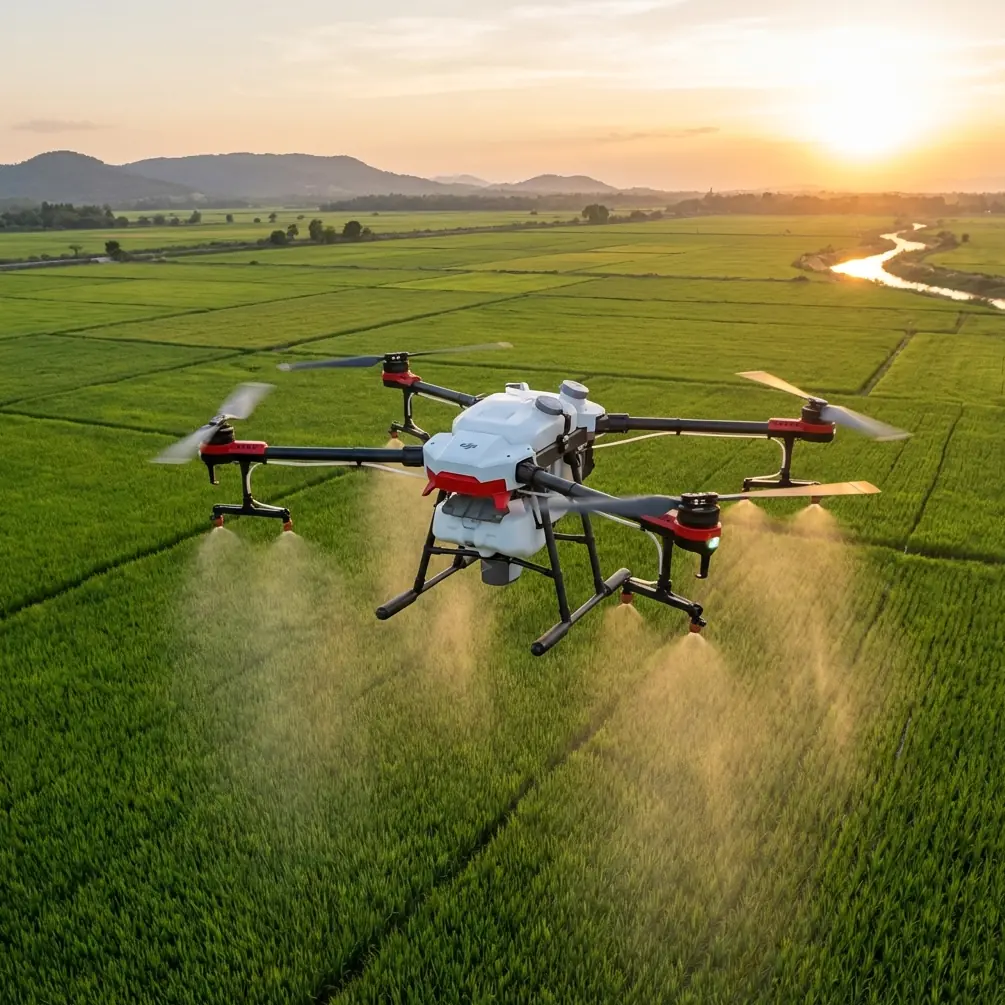
Mountain vineyard scouting presents unique challenges that flat-terrain operations never encounter. Signal dropouts behind ridgelines, inconsistent RTK corrections on steep slopes, and unpredictable wind patterns through valleys can transform a routine scouting mission into a frustrating exercise. This guide delivers field-tested antenna positioning strategies and operational protocols that ensure your Agras T50 performs flawlessly across challenging mountain vineyard terrain.
Understanding Mountain Terrain Challenges for Drone Scouting
Vineyard operations in mountainous regions demand respect for the environment's complexity. Unlike valley-floor agriculture, mountain vineyards present elevation changes exceeding 200 meters within single blocks, creating signal shadows and GPS multipath errors that degrade positioning accuracy.
The Agras T50's dual-antenna RTK system provides centimeter precision positioning—but only when properly configured for terrain-specific challenges. Without correct setup, that precision degrades to meter-level accuracy, rendering your scouting data unreliable for precision viticulture decisions.
Signal Propagation in Valley Environments
Radio signals behave differently in mountain environments. Valleys create natural channels that can either amplify or attenuate signal strength depending on your antenna orientation.
Key factors affecting signal quality:
- Fresnel zone obstructions from ridgelines and tree canopy
- Multipath interference from rocky outcrops reflecting signals
- Atmospheric ducting during temperature inversions common in mountain mornings
- Terrain shadowing blocking direct line-of-sight to base stations
Expert Insight: Schedule scouting missions between 10:00 AM and 2:00 PM when thermal inversions have dissipated. Morning temperature layers create unpredictable signal refraction that degrades RTK Fix rate by 15-20% compared to midday operations.
Antenna Positioning Strategies for Maximum Range
The single most impactful adjustment you can make for mountain vineyard operations involves base station antenna positioning. Standard tripod placement on flat ground works adequately for level terrain—mountain operations require elevated positioning strategies.
Elevated Base Station Placement Protocol
Position your RTK base station on the highest accessible point overlooking your target vineyard blocks. This typically means:
- Ridgeline placement above the vineyard canopy
- Minimum 10-meter elevation advantage over the highest point in your flight zone
- Clear 360-degree horizon with no obstructions above 5 degrees elevation angle
- Stable mounting surface resistant to wind-induced vibration
The T50's communication system operates on 2.4GHz and 5.8GHz frequencies with automatic switching. Higher frequencies provide faster data rates but suffer greater atmospheric attenuation. Elevated positioning reduces the signal path through dense air layers near the ground.
Drone Antenna Orientation During Flight
The T50 features omnidirectional antennas that theoretically receive signals equally from all directions. Real-world performance tells a different story.
During banking turns and attitude changes on sloped terrain, antenna orientation relative to the base station shifts dramatically. Maintaining awareness of this relationship improves connection reliability.
Practical recommendations:
- Plan flight paths that keep the drone's top surface oriented toward the base station during critical data collection phases
- Avoid sustained sideways flight perpendicular to the base station direction
- Program waypoint missions with gentle turns rather than sharp direction changes
- Monitor signal strength indicators during initial test flights to identify problem orientations
Pro Tip: Mark your base station location on the controller map and mentally track the drone's orientation relative to that point. When signal strength drops, you'll immediately understand why and can adjust flight behavior accordingly.
RTK Configuration for Sloped Terrain
Achieving consistent RTK Fix status across mountain vineyards requires configuration adjustments beyond default settings. The T50's RTK system can maintain centimeter precision on slopes exceeding 35 degrees—but only with proper setup.
Base Station Survey Methods
Three survey methods exist for establishing base station position:
| Survey Method | Accuracy | Setup Time | Best Application |
|---|---|---|---|
| Manual Input | ±2cm | 2 minutes | Known survey markers |
| Self-Survey | ±1.5m | 10 minutes | Relative positioning only |
| NTRIP Network | ±2cm | 3 minutes | Areas with cellular coverage |
For mountain vineyards, manual input using known survey points delivers the best results. Many vineyard operations have existing survey markers from planting or irrigation installation. Using these coordinates eliminates base station position uncertainty entirely.
Maintaining Fix Status on Steep Slopes
The T50's dual-antenna system calculates both position and heading from satellite signals. On steep slopes, the effective satellite constellation visible to the drone changes as terrain blocks portions of the sky.
Configuration adjustments for sloped operations:
- Increase elevation mask to 15 degrees to exclude low-elevation satellites prone to multipath
- Enable GLONASS and Galileo constellations alongside GPS for maximum satellite availability
- Set position update rate to 10Hz for responsive terrain following
- Configure RTK age limit to 2 seconds to flag degraded corrections quickly
Multispectral Scouting Protocols for Vineyards
The T50's compatibility with multispectral imaging payloads transforms vineyard scouting from visual inspection to quantitative analysis. Detecting vine stress before visible symptoms appear enables intervention weeks earlier than traditional scouting methods.
Spectral Bands for Viticulture
Effective vineyard scouting utilizes specific spectral bands:
- Red Edge (710-740nm): Chlorophyll content and nitrogen status
- Near-Infrared (840-880nm): Canopy density and biomass estimation
- Red (660-680nm): Chlorophyll absorption for stress detection
- Green (540-560nm): Peak reflectance for vigor assessment
Combining these bands into vegetation indices like NDVI and NDRE reveals patterns invisible to standard cameras. Early-season water stress, nutrient deficiencies, and disease pressure all create spectral signatures detectable 10-14 days before visual symptoms manifest.
Flight Parameters for Quality Data
Multispectral data quality depends heavily on consistent capture conditions:
- Altitude: Maintain 30-40 meters AGL for optimal ground sampling distance
- Overlap: Configure 75% frontal and 65% side overlap for accurate orthomosaic generation
- Speed: Limit to 5 m/s to prevent motion blur in spectral bands
- Timing: Capture within 2 hours of solar noon to minimize shadow effects
The T50's terrain-following capability proves essential here. Mountain vineyards with elevation changes exceeding 50 meters within single blocks would create unacceptable altitude variation without active terrain compensation.
Swath Width Calibration for Accurate Coverage
When transitioning from scouting to spray applications, proper swath width calibration prevents both gaps and excessive overlap. Mountain terrain complicates this calculation significantly.
Slope Compensation Factors
Effective swath width decreases on slopes as the spray pattern projects onto an angled surface. A 10-meter swath on flat ground becomes approximately 9.8 meters on a 15-degree slope and 9.4 meters on a 25-degree slope.
The T50's flight controller can compensate automatically when properly configured:
- Enable slope compensation in spray settings
- Input accurate terrain data from your scouting flights
- Verify nozzle calibration matches your spray material viscosity
- Test pattern width on representative slopes before full-block application
Wind Considerations in Mountain Valleys
Spray drift presents heightened concerns in mountain environments where wind patterns shift rapidly. Valley thermals create predictable but strong afternoon winds that can carry spray material hundreds of meters from target areas.
The T50's IPX6K rating ensures reliable operation in challenging conditions, but spray efficacy depends on calm air. Schedule applications during:
- Early morning before thermal development
- Late evening after thermal collapse
- Overcast days when solar heating remains minimal
Common Mistakes to Avoid
Positioning base stations in valleys: The temptation to set up near your vehicle proves costly. Valley floor placement guarantees signal blockage as the drone moves behind terrain features. Always invest the extra effort to position base stations on elevated terrain.
Ignoring satellite geometry: Flying when PDOP exceeds 2.0 invites positioning errors. The T50 displays satellite geometry metrics—use them. Postpone missions when geometry degrades rather than accepting compromised data quality.
Rushing calibration procedures: Compass calibration in mountain environments requires extra attention. Magnetic anomalies from iron-rich soils and rock formations create localized disturbances. Calibrate at your actual operating location, not at a convenient parking area.
Underestimating battery consumption: Terrain-following flight on slopes consumes 20-30% more battery than equivalent flat-terrain operations. Plan conservative mission durations and maintain larger reserves than you would for valley operations.
Neglecting wind gradient effects: Wind speed increases with altitude. Ground-level calm conditions may mask significant winds at flight altitude. Always verify conditions at operating height before committing to spray applications.
Frequently Asked Questions
What RTK Fix rate should I expect in mountain vineyard operations?
With proper base station positioning on elevated terrain, expect 95-99% RTK Fix rate during missions. Rates below 90% indicate positioning problems requiring correction before proceeding. The T50's dual-antenna system maintains Fix status more reliably than single-antenna alternatives, but terrain shadowing will still cause brief Float periods when flying behind ridgelines relative to your base station.
How does slope angle affect multispectral data accuracy?
Slopes up to 25 degrees produce reliable multispectral data with standard processing. Steeper slopes require specialized orthorectification that accounts for viewing angle effects on reflectance measurements. The T50's terrain-following maintains consistent altitude, but the camera's viewing geometry changes on slopes, affecting apparent reflectance values. Process steep-slope data separately with appropriate corrections.
Can the T50 handle the wind conditions typical in mountain vineyards?
The T50 maintains stable flight in sustained winds up to 8 m/s and gusts to 12 m/s. Mountain valley winds frequently exceed these limits during afternoon thermal development. Plan operations for morning hours when conditions remain calmer. The aircraft's IPX6K rating handles moisture from morning fog common in mountain environments, but wind limitations remain the primary constraint for mountain operations.
Mountain vineyard scouting with the Agras T50 delivers exceptional results when operators understand and accommodate terrain-specific challenges. The strategies outlined here—elevated antenna positioning, proper RTK configuration, and terrain-aware flight planning—transform difficult mountain operations into reliable, repeatable workflows that maximize the T50's precision agriculture capabilities.
Ready for your own Agras T50? Contact our team for expert consultation.