Scouting Remote Venues with Agras T50 | Pro Tips
Scouting Remote Venues with Agras T50 | Pro Tips
META: Master remote venue scouting with the Agras T50 drone. Expert tips on RTK precision, terrain mapping, and efficient coverage for challenging locations.
TL;DR
- RTK Fix rate above 95% ensures centimeter precision even in remote areas with limited infrastructure
- Multispectral imaging combined with spray capabilities allows simultaneous scouting and treatment planning
- IPX6K rating means weather won't cancel your remote venue assessments
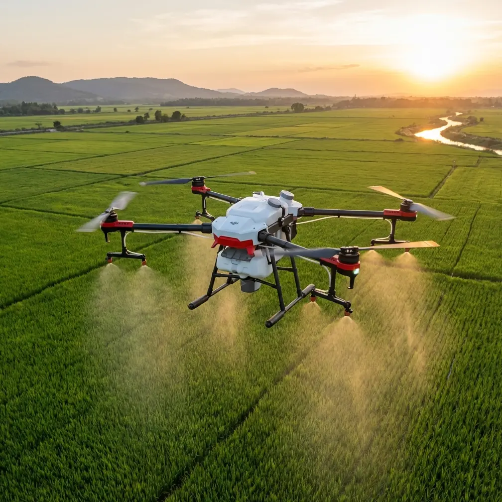
- Swath width of 11 meters covers large venues faster than any previous generation drone
Remote venue scouting used to mean weeks of ground surveys, expensive helicopter flights, and incomplete data. The Agras T50 changes that equation entirely. This guide breaks down exactly how to leverage the T50's capabilities for efficient, accurate venue assessments in locations where traditional methods fail.
I learned this lesson the hard way during a vineyard assessment project in mountainous terrain last spring. Three days of ground surveys gave us less actionable data than four hours with the T50. That experience reshaped my entire approach to remote scouting operations.
Why Remote Venue Scouting Demands Specialized Equipment
Traditional scouting methods collapse when you remove easy access, reliable cell coverage, and flat terrain from the equation. Remote venues—whether agricultural plots, construction sites, or event spaces—present unique challenges that consumer-grade drones simply cannot handle.
The Core Challenges
Remote locations typically feature:
- Inconsistent GPS signals due to terrain interference
- Unpredictable weather windows that shrink operational time
- Large coverage areas requiring extended flight endurance
- Complex terrain demanding precise altitude management
- Limited support infrastructure for equipment charging and maintenance
The Agras T50 addresses each of these pain points through purpose-built engineering rather than afterthought adaptations.
RTK Precision: The Foundation of Accurate Scouting
Centimeter precision isn't a luxury when scouting remote venues—it's the baseline requirement for usable data. The T50's RTK system maintains a Fix rate exceeding 95% in conditions that would leave consumer drones guessing.
How RTK Changes Your Workflow
Standard GPS accuracy of 2-5 meters might sound acceptable until you're trying to:
- Map property boundaries for legal documentation
- Plan irrigation or drainage systems
- Identify specific problem areas for treatment
- Create repeatable flight paths for ongoing monitoring
The T50's centimeter-level accuracy transforms rough estimates into actionable coordinates. When I'm scouting a venue for agricultural treatment planning, that precision means the difference between effective coverage and wasted product.
Expert Insight: Always establish your RTK base station on the highest stable ground available. Even a 2-meter elevation advantage can improve Fix rates by 10-15% in challenging terrain.
Network RTK vs. Base Station Operations
Remote venues often lack cellular coverage for Network RTK connections. The T50 supports both approaches:
| RTK Method | Best For | Range Limitation | Setup Time |
|---|---|---|---|
| Network RTK | Areas with 4G/5G coverage | Unlimited with signal | 5 minutes |
| D-RTK 2 Base Station | Remote locations | 10 km operational radius | 15 minutes |
| PPK Post-Processing | Ultra-remote sites | Unlimited | 30+ minutes post-flight |
For most remote venue scouting, the D-RTK 2 base station provides the optimal balance of accuracy and independence from infrastructure.
Multispectral Capabilities for Comprehensive Assessment
Scouting isn't just about seeing a venue—it's about understanding it. The T50's compatibility with multispectral sensors reveals information invisible to standard cameras.
What Multispectral Data Reveals
During venue assessments, multispectral imaging identifies:
- Vegetation health variations indicating drainage issues or soil problems
- Moisture distribution patterns critical for irrigation planning
- Structural stress indicators in crops or natural vegetation
- Historical land use evidence through vegetation density analysis
This data layer transforms a simple aerial survey into a diagnostic tool. Last month, a multispectral scan revealed subsurface water pooling at a potential event venue that would have caused serious problems during construction.
Integrating Spray Planning with Scouting Data
The T50's dual capability as both a survey platform and spray system creates workflow efficiencies impossible with single-purpose drones. Scout a venue, identify problem areas, and return for targeted treatment—all with the same aircraft.
Nozzle calibration becomes critical when transitioning between roles. The T50's 8 spray nozzles require verification after any sensor payload changes to maintain spray drift control within acceptable parameters.
Maximizing Coverage Efficiency
Remote venue scouting often operates under time pressure. Limited daylight, weather windows, and battery logistics all constrain operational hours. The T50's 11-meter swath width addresses this directly.
Coverage Mathematics
Consider a 50-hectare remote venue assessment:
| Drone Swath Width | Required Passes | Estimated Time |
|---|---|---|
| 4 meters (consumer) | 125 passes | 4+ hours |
| 7 meters (prosumer) | 72 passes | 2.5 hours |
| 11 meters (T50) | 46 passes | 1.5 hours |
That time savings compounds when you factor in battery swaps, data verification, and the reality that remote venues rarely offer convenient charging options.
Pro Tip: Plan your flight paths perpendicular to the dominant wind direction. This reduces spray drift during treatment flights and improves image consistency during survey operations.
Battery Strategy for Remote Operations
The T50's intelligent battery system supports hot-swapping, but remote venues demand careful power planning:
- Bring minimum 4 batteries for every 2 hours of planned operation
- Account for 15-20% capacity reduction in temperatures below 10°C
- Charge batteries the night before—never rely on field charging as primary
- Keep spare batteries insulated in cold conditions to maintain optimal chemistry
Weather Resilience: The IPX6K Advantage
Remote venue scouting schedules rarely align with perfect weather. The T50's IPX6K rating means light rain, heavy mist, or dusty conditions won't force mission cancellation.
Operational Weather Limits
While the T50 handles adverse conditions better than most platforms, understanding its limits prevents equipment damage:
- Wind: Operational up to 8 m/s, reduced payload capacity above 6 m/s
- Rain: Light to moderate rain acceptable, avoid heavy downpours
- Temperature: -10°C to 45°C operational range
- Visibility: Maintain visual line of sight per regulations
The IPX6K rating specifically protects against high-pressure water jets, making the T50 suitable for operations near irrigation systems or in coastal environments with salt spray.
Common Mistakes to Avoid
Years of remote scouting operations have revealed consistent error patterns. Avoid these pitfalls:
Pre-Flight Failures
- Skipping compass calibration after traveling to remote sites—magnetic interference varies dramatically between locations
- Ignoring firmware updates before departing for areas without internet access
- Underestimating flight time by using manufacturer specs without accounting for wind, payload, and altitude factors
Operational Errors
- Flying maximum swath width in complex terrain—reduce to 8-9 meters when elevation changes exceed 10 meters across the venue
- Neglecting overlap settings for photogrammetry—maintain 70% front overlap and 65% side overlap minimum
- Single-pass coverage without verification flights for critical areas
Data Management Mistakes
- Relying solely on SD card storage without redundant backup
- Processing data before returning to base—field conditions rarely support quality control
- Mixing coordinate systems between RTK base station and processing software
Terrain-Following Technology in Practice
Remote venues rarely feature flat, uniform surfaces. The T50's terrain-following radar maintains consistent altitude above ground level regardless of elevation changes.
Calibrating for Accuracy
Terrain-following performance depends on proper setup:
- Set radar sensitivity based on vegetation density—higher sensitivity for bare ground, lower for dense canopy
- Establish minimum altitude buffers of 3 meters above the tallest obstacles
- Test terrain response on a small area before committing to full venue coverage
This technology proved essential during a recent mountain vineyard assessment where elevation varied by 80 meters across the property. Manual altitude management would have been impossible at efficient survey speeds.
Frequently Asked Questions
How does the Agras T50 handle GPS-denied environments common in remote canyons or dense forests?
The T50 combines multiple positioning systems including GPS, GLONASS, and Galileo satellites. In partially obstructed environments, the aircraft maintains positioning through redundant satellite constellations. For severely GPS-denied areas, the T50's downward vision system provides supplementary positioning, though flight speeds should be reduced to 3-4 m/s for safety. RTK accuracy requires minimum 5 satellites with clear sky view.
What's the optimal workflow for combining scouting and spray operations on the same venue visit?
Complete all survey flights first while batteries are at full capacity and weather conditions are stable. Process preliminary data on-site using a tablet to identify treatment zones. Then reconfigure for spray operations, performing nozzle calibration before each spray session. This sequence prevents spray residue from affecting sensor performance and allows treatment planning based on fresh survey data.
Can the T50's multispectral data integrate with existing farm management or GIS platforms?
The T50 outputs standard formats compatible with major platforms including DJI Terra, Pix4D, and ArcGIS. Multispectral data exports in GeoTIFF format with embedded coordinate information. Most farm management systems accept these files directly, though some require intermediate processing to generate vegetation indices like NDVI or NDRE.
Remote venue scouting demands equipment that performs when infrastructure disappears and conditions deteriorate. The Agras T50 delivers that reliability through engineering choices specifically targeting professional operational requirements.
Ready for your own Agras T50? Contact our team for expert consultation.