Agras T50 for Coastal Field Scouting and Spray Planning
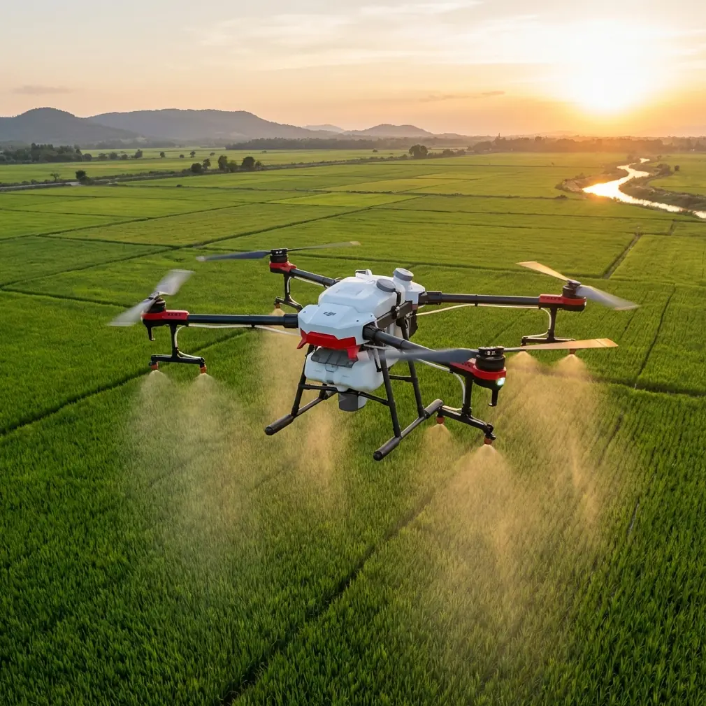
Agras T50 for Coastal Field Scouting and Spray Planning: What Actually Matters in Windy Conditions
META: A technical review of Agras T50 for windy coastal scouting, with practical insight on spray drift, swath discipline, RTK precision, nozzle calibration, and why route design matters more than brochure specs.
Wind changes everything.
That was the lesson from one of the harder agricultural site assessments I’ve worked on: a coastal block where salt air, uneven ground, and persistent crosswinds turned an ordinary crop protection plan into a precision problem. On paper, the mission looked simple. In practice, every pass had consequences. Drift margins tightened. Coverage uniformity became harder to maintain. Pilot workload went up fast.
That is the context in which the Agras T50 deserves to be judged.
Not as a generic “big agricultural drone,” and not as a machine evaluated in perfectly calm inland conditions, but as a platform that has to hold a disciplined line when the environment keeps trying to pull the operation off-axis. For readers scouting windy coastal farmland, embankments, sloped tea plots, or other exposed growing areas, the useful question is not whether the T50 is powerful. It is whether the aircraft helps you structure a repeatable operation when precision begins to erode.
My view: the T50 becomes most valuable when you treat it as a route-control and consistency tool, not merely as a flying tank.
Why coastal scouting changes how you should think about the T50
Coastal agriculture exposes weak planning.
Wind from open water can create lateral push even when conditions seem manageable at takeoff. Terrain near shorelines often includes gradual rises, drainage cuts, and uneven canopies. If your aircraft holds altitude relative to takeoff point rather than relative to crop surface, application quality can deteriorate row by row. That is where terms like spray drift, swath width, nozzle calibration, and RTK fix rate stop being technical decoration and start becoming operational variables.
The Agras T50 sits in a category where centimeter-level route discipline matters. If you are scouting or planning treatments in exposed areas, that precision is tied directly to three outcomes:
- Whether the spray reaches the intended canopy
- Whether adjacent passes overlap correctly
- Whether the operator can maintain confidence under shifting wind pressure
Those outcomes are not abstract. They can be mapped back to the kind of route logic described in agricultural training materials and policy frameworks that shaped the rise of farm aviation in China.
The overlooked lesson from a tea-slope training scenario
One of the most revealing reference points is not a commercial spec sheet at all, but an educational drone exercise built around simulated spraying over a hillside tea garden. In that example, the slope is given a height of 35 centimeters, with a right slope length of 100 centimeters, a left slope length of 50 centimeters, a width of 120 centimeters, and a flight line spacing of 30 centimeters. The aircraft is instructed to maintain 80 centimeters above the tea trees rather than a fixed height above level ground.
That detail matters far more than it may seem.
The core lesson is that agricultural flight quality depends on crop-relative altitude, not simply airframe stability. On sloped or irregular sites, a drone that can execute a planned pattern while maintaining the intended working distance from vegetation will deliver more consistent deposition and reduce the operational conditions that contribute to drift and undercoverage.
For Agras T50 operators, this translates into a practical planning principle: if you are working coastal orchards, terraced plots, or tea-like slopes, route design should assume variable ground relationship from the beginning. A flat-field mindset produces poor results in non-flat geography.
The same training scenario also uses a structured task flow: the drone moves forward 30 centimeters into the treatment zone, begins simulated spraying with a status light change, completes the cycle twice, then exits the area and lands. Even in miniature, this is a serious operational concept. Entry, treatment, exit, confirmation. The logic is disciplined. That same discipline is what makes a T50 operation safer and cleaner in windy environments. You want clear zone transitions, predictable pass timing, and unambiguous task completion states.
A powerful aircraft is useful. A predictable mission architecture is better.
What this means for Agras T50 in real field use
The T50 is best understood as a system that benefits from pre-planned geometry. In windy coastal areas, the temptation is to react continuously in manual style—nudge left, compensate right, shorten a pass, widen the next one. The trouble is that this kind of flying often magnifies inconsistency across the whole block.
A more effective T50 workflow starts with route integrity.
That means defining swath width conservatively when wind is variable, validating nozzle calibration before launch, and verifying RTK fix stability so the aircraft is not merely flying accurately in a general sense, but repeating the intended path with centimeter precision. This is where RTK fix rate becomes more than an engineering metric. If the aircraft is frequently losing or degrading positional quality, your overlap pattern and edge discipline can suffer, especially near boundaries, drainage edges, or roads.
For coastal operators, that issue compounds because wind can hide minor tracking errors until they become obvious in the treatment result.
The policy angle explains why this class of aircraft matters
Another reference source, a drone industry policy document, notes that Henan selected agricultural aircraft as a new-product subsidy pilot category under the 2015–2017 agricultural machinery purchase subsidy guidance. That was not an administrative footnote. It reflected a larger recognition: farm aviation was moving from novelty status into mechanized crop protection infrastructure.
This has two implications for evaluating the Agras T50 today.
First, aircraft like the T50 belong to a mature operational category shaped by expectations around fairness, transparency, standardization, and measurable field utility. In other words, this is no longer about whether drones can spray. That argument is over. The real issue is whether a specific platform supports reliable, auditable, repeatable agricultural work.
Second, the policy emphasis on strengthening unified pest and disease control speaks directly to consistency across larger areas. For commercial operators, consistency is everything. If one section of a coastal field gets excessive overlap while another suffers from drift loss, the machinery may be technically impressive but agronomically disappointing.
The T50 should therefore be assessed the same way serious mechanization is assessed: by output uniformity, route repeatability, and ability to support disciplined operating procedures in less-than-ideal conditions.
A surprising lesson from smartphone photography
One of the source items seems unrelated at first glance: a phone photography article recommending users enable the built-in grid and place the subject near one of the four intersection points, following the rule of thirds. The stated goal is a more stable composition that avoids awkward centering and crooked images.
That advice has a useful parallel for drone route planning.
Good aerial agricultural work also depends on visual and spatial structure. The operator who thinks in grids usually outperforms the operator who thinks in impulses. In photography, the grid prevents a scene from feeling unstable. In drone operations, grid logic prevents coverage from becoming uneven. When pilots scout a windy coastal plot with a T50, they should be mentally framing the site the same way a careful photographer frames an image: identify edges, define intersections, resist drift toward the center simply because it feels intuitive, and maintain alignment so the overall pattern remains balanced.
This is especially valuable when inspecting field geometry before treatment. If there are irregular margins, utility poles, trees, or broken rows near the shoreline, a grid-based mindset makes it easier to decide where the pass sequence should begin and where buffer discipline matters most.
It sounds simple. It is not trivial.
Most field inconsistency starts as a geometry problem before it becomes a spray problem.
Spray drift starts before the droplets leave the aircraft
People often discuss spray drift as if it were only a meteorological issue. Wind speed matters, of course. But drift risk begins earlier, in planning decisions.
With the Agras T50, three planning errors are common in exposed environments:
1. Overestimating usable swath width
A wide theoretical swath can collapse under crosswind. In coastal conditions, reducing effective swath width may improve coverage quality more than trying to preserve nominal productivity.
2. Ignoring nozzle calibration discipline
Nozzle calibration is not glamorous, but it decides whether the planned application rate matches what the crop actually receives. When wind is already working against you, poor calibration adds another layer of uncertainty.
3. Treating slope like flat land
The tea-garden training example’s 80-centimeter crop-relative height is the key concept here. If working height varies unintentionally across undulating terrain, droplet behavior and canopy penetration change too.
This is where the T50 earns its keep if the operator uses it properly. A capable aircraft can support a tighter execution envelope, but only if the mission is built around real field geometry.
RTK precision is not just a mapping luxury
In scouting conversations, RTK often gets discussed as if it belongs mostly to surveying or mapping workflows. For agricultural drone work, especially in windy coastal areas, that is too narrow.
Centimeter precision has direct practical value in repeat-pass spraying, edge management, and return missions after interruptions. If you pause due to wind shifts, refill cycles, or safety checks, the ability to re-enter the route cleanly matters. It reduces uncertainty at the restart point and lowers the chance of skipped strips or doubled application.
That is one reason RTK fix rate deserves attention in T50 operations. Stable positioning is not simply a “nice spec.” It supports confidence when the environment is already dynamic.
For teams evaluating site suitability or route setup, I often recommend discussing the mission in terms of tolerance to error, not just area coverage. Windy coastal work has low tolerance for sloppiness. The T50’s value grows when it narrows that error band.
Durability and exposure matter more near the coast
The context supplied for this piece hints at IPX6K durability, and that makes sense in a maritime or salt-laden operating environment. Coastal deployments are hard on equipment. Moisture, residue, and corrosive airborne particles create a harsher service reality than many inland users expect.
An aircraft intended for agricultural work should not be judged only by what it can carry or how quickly it can cover area, but by how well it stands up to repetitive exposure, washdown routines, and demanding turnaround cycles. The T50 belongs in that conversation because field reliability is part of productivity. Downtime caused by environmental stress is still lost output.
Where the T50 fits best
The Agras T50 makes the strongest case for itself in operations where structure beats improvisation:
- exposed coastal farmland
- sloped specialty crops
- repetitive block treatments requiring tight overlap control
- sites where route restarts must be accurate
- teams that care about documented, repeatable procedures
If your use case involves scouting treatment zones before execution, it also helps to think beyond flight itself. Field geometry, entry and exit path, refill logistics, wind direction relative to row orientation, and buffer areas near sensitive boundaries all affect whether the mission will be efficient or messy.
If you are evaluating that workflow and want a practical discussion around route design, drift control, or whether a site’s exposure makes the T50 a strong fit, you can message an Agras specialist here.
My bottom-line assessment
The Agras T50 should not be reduced to payload talk or generic performance claims. Its real value appears in disciplined field operations where route precision, drift management, and terrain-aware planning determine the result.
The two most useful lessons from the source material are surprisingly durable. First, from the tea-slope drone exercise: maintain working height relative to the crop, not just to the launch surface. The 35-centimeter slope model, 30-centimeter line spacing, and 80-centimeter crop clearance are miniature numbers carrying a very real professional lesson. Second, from the photography grid tip: stable outcomes come from deliberate framing. In drone work, that means route geometry, not guesswork.
For windy coastal scouting and agricultural planning, that is the lens through which I would evaluate the T50. Not as a machine that removes complexity, because it doesn’t. Coastal work remains complex. But as a platform that makes complexity more manageable when the operator respects geometry, calibration, and precision.
That difference is where good agricultural drone operations live.
Ready for your own Agras T50? Contact our team for expert consultation.