Agras T50 Guide for Remote Wildlife Monitoring
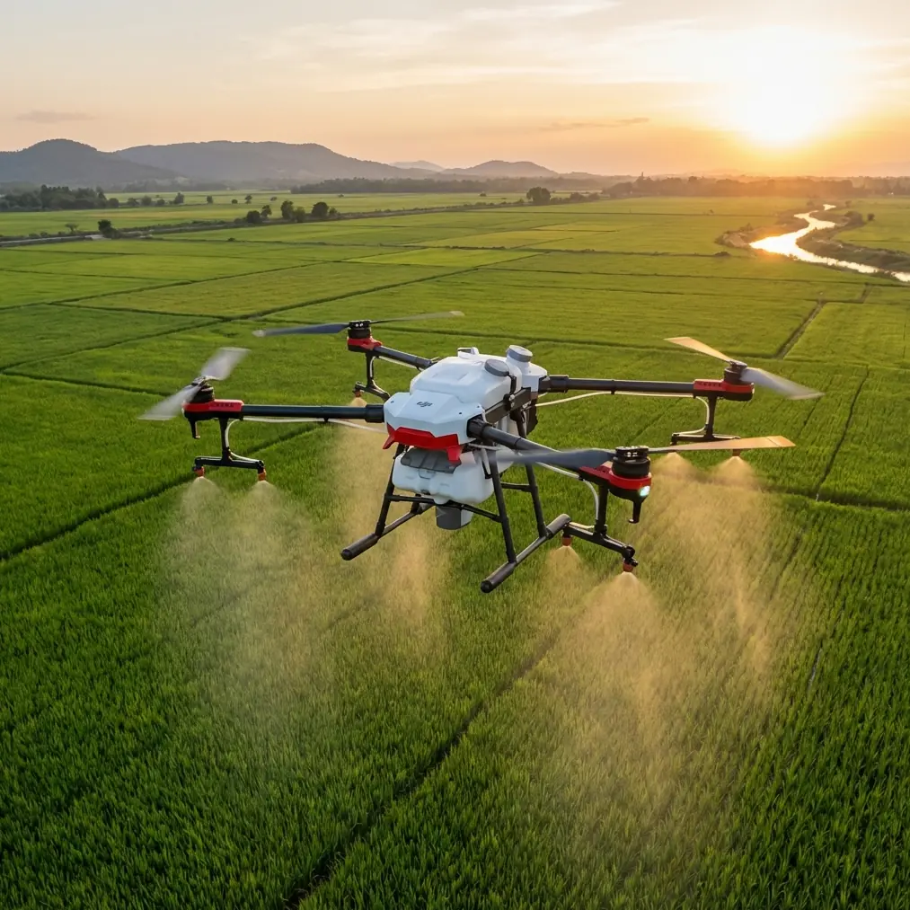
Agras T50 Guide for Remote Wildlife Monitoring: A Smarter Field Workflow, Not Just a Bigger Drone
META: A practical Agras T50 tutorial for remote wildlife monitoring, covering pre-flight cleaning, precision flight logic, scene-based imaging decisions, RTK-aware operations, and safe low-disturbance field workflows.
Remote wildlife work punishes sloppy habits.
Mud on a sensor window. Residue around a nozzle body. A rushed launch without checking vision surfaces. One of those small misses can turn a precise mission into a noisy, inefficient flight that stresses animals, wastes battery time, and leaves you with weak data.
That is why the most useful way to think about the Agras T50 is not as a single-purpose spraying machine, but as a field platform that rewards disciplined setup and intelligent automation. For teams monitoring wildlife in remote areas, especially across wetlands, grassland edges, reforestation blocks, or difficult agricultural interfaces, the T50’s value comes from consistency. Consistency in height, consistency in route execution, and consistency in how onboard systems behave when conditions get messy.
The trap many operators fall into is the same one photographers argue about online. There is a persistent belief that “real professionals” only work in fully manual modes. A recent photography piece pushed back on that idea, pointing out that scene modes are often dismissed as beginner tools even though they are really smart packages of proven settings. That argument applies surprisingly well to drone fieldwork.
With the Agras T50, the best operators are not the ones who insist on hand-flying every pass or rebuilding every parameter from scratch. They are the ones who know when to let the aircraft’s structured logic do the heavy lifting, and when to intervene.
Start with cleaning, because safety features only work if they can see
Before talking about mission plans, imaging choices, or RTK fix rate, start with the least glamorous step: cleaning.
If your Agras T50 is going out to monitor wildlife in remote terrain, inspect and clean the surfaces that support obstacle sensing, positioning, and stable low-altitude flight. That includes the camera and vision windows, radar-related surfaces if exposed to dust or spray residue, landing gear contact areas, lighting elements, and the underside zones that may pick up mud, seed coating, fertilizer residue, or splashback from previous agricultural work. If the aircraft has been used for liquid application, also inspect nozzle bodies, hose junctions, and pump-adjacent areas so dried material does not migrate where it should not.
Why does this matter for wildlife monitoring? Because remote observation flights often happen at lower altitudes over uneven terrain, near shrubs, water edges, or irregular field margins where the aircraft depends on clean sensor input to hold stable behavior. A drone with dirty sensing surfaces can become less predictable just when you need precision and low disturbance most.
This is also where IPX6K-class protection matters in practical terms. It does not mean “ignore maintenance.” It means the T50 is built for harsh washdown-friendly field conditions, which is exactly what remote operators need after dusty roads, damp grass takeoffs, and long deployments. Ruggedness is a support feature, not an excuse to skip inspection.
Remote wildlife monitoring is really a precision-flight problem
A lot of people imagine wildlife monitoring as a camera problem. It is really a flight-control problem first.
If you cannot repeat an altitude cleanly, hold line discipline across changing ground contours, or return to the same corridor with centimeter precision, your imagery becomes harder to compare over time. Animal counts drift. Habitat change analysis gets weaker. Disturbance increases because you need extra passes.
This is where RTK matters. A strong RTK fix rate is not just a specification to admire in a brochure. In the field, it is the difference between “roughly the same route” and “the same route with enough repeatability to trust trend data.” When you are watching seasonal movement patterns, nesting-edge behavior, or crop-wildlife boundary activity, repeatability is what makes observations meaningful.
Centimeter precision also helps reduce unnecessary air time. That sounds obvious, but in wildlife work it carries ethical value. Fewer correction passes mean less rotor noise over the habitat.
Use structured modes the way good photographers use scene modes
That photography article used a sunset example: someone using a landscape mode could quickly produce sunset, silhouette, and reflection shots without spending too long manually tuning every variable. The underlying point was not that manual control is bad. It was that smart presets are often underestimated.
The same mindset helps on the Agras T50.
If you are planning a remote wildlife monitoring mission, don’t treat automated route logic as training wheels. Treat it as parameter packaging. A carefully chosen route type, height profile, swath width, overlap pattern, and return behavior can outperform improvised manual flying in both quality and safety.
This matters especially when the operator is dealing with environmental distractions: changing wind, patchy connectivity, reflective water, tree lines, and rough staging zones. Automation lowers cognitive load. Lower cognitive load means better judgment when something actually needs human attention.
The lesson is simple: expertise is not proven by refusing assistance. Expertise is proven by selecting the right level of assistance.
A useful training model comes from a very different drone document
One of the most interesting reference documents here is not about agriculture at all. It describes an education drone exercise where the aircraft rises to 150 centimeters, hovers, identifies a card below it, and then keeps following that moving card while maintaining a relative height of 80 centimeters above it. When a different card number appears, the drone ends the loop and lands.
That tiny training sequence is more relevant to Agras T50 fieldwork than it looks.
Why? Because it demonstrates three principles that matter in remote wildlife monitoring:
- Stable initial hover before task execution
- Maintaining a constant relative height over a moving reference
- Using recognition logic to trigger a controlled mission change
Those are exactly the habits you want when flying the T50 near sensitive habitat boundaries. You should not be improvising from the moment of takeoff. Launch, stabilize, verify telemetry, confirm positioning integrity, then begin the actual monitoring pattern. The educational example’s 150-centimeter hover is a reminder that good missions begin with a deliberate pause, not a hurried departure.
The 80-centimeter relative-height concept also carries operational significance. In real field use, your numbers will be very different, but the principle stands: what matters is not just absolute altitude, but stable relationship to terrain or target zone. If the drone drifts in relative height over uneven ground, image consistency degrades and wildlife disturbance may increase.
Even the “card changes and the drone lands” logic has value. On a professional platform, your triggers are not literal printed cards, but the concept of clear state changes is essential. Low battery threshold, wind threshold, completed route block, geofence event, or operator-confirmed stop condition should produce predictable aircraft behavior. Ambiguity in remote areas is expensive.
Think in transitions, not just straight lines
A second reference, from model aircraft aerobatic training, makes a subtle but powerful point: good flying depends on setting up the next maneuver early, staying level before correction, and using a brief pause to observe before acting. It also notes that one turn sequence, the half Cuban eight, is useful when the aircraft has drifted too far away and you want to bring it back while keeping altitude relatively constant.
You are obviously not flying aerobatics with an Agras T50, but the decision logic is familiar.
Remote wildlife monitoring often breaks down during transitions: end of a transect, reposition after obstacle avoidance, return from an overextended leg, or setup for the next observation corridor. Less experienced operators focus on the main line and then get sloppy in the turns. That is where route consistency falls apart.
The aerobatic lesson is operationally significant because it reinforces two things:
- Corrections work best when the aircraft is first stabilized
- A return path should solve distance and position problems without creating altitude errors
For T50 operators, that means every mission should include calm, preplanned transition behavior. If the aircraft drifts farther than intended from the observation area, the response should not be an abrupt, noisy manual yank back toward target. It should be a smooth reposition that preserves data quality and keeps the aircraft’s profile predictable.
That kind of discipline is what separates usable wildlife survey output from random clips and uneven logs.
A field workflow that fits the Agras T50
Here is a practical workflow I recommend for remote wildlife monitoring tasks that intersect with agricultural land, restoration acreage, or managed habitat.
1) Pre-flight cleaning and mechanical check
Clean sensor windows and the underside. Check for residue around spray-related hardware even if the day’s mission is observation only. Confirm arms, props, battery seating, and landing gear condition.
If the aircraft recently handled application work, verify nozzle calibration status and make sure there is no leftover contamination that could affect airflow, balance, or field hygiene. Spray drift may sound unrelated to monitoring, but if your T50 alternates between application and survey roles, any residue management failure becomes a cross-mission risk.
2) Positioning integrity before launch
Wait for stable GNSS and confirm RTK behavior. A weak RTK fix rate can undermine mission repeatability before you even leave the ground. In wildlife work, route repeatability is part of the data itself.
3) Deliberate hover phase
Borrow the educational-drone mindset: launch, climb, and hold a brief stable hover before entering the route. This is your final check for vibration, control responsiveness, telemetry, and environmental surprises.
4) Use route logic, not ego
Choose a mission structure that matches the terrain. If the area is broad and open, optimize swath width for efficient visual coverage. If the habitat is fragmented, use narrower route blocks with conservative transitions.
Even though the T50 is associated with spray productivity, swath width thinking is still valuable for monitoring. It forces you to define what one useful pass actually covers, which prevents redundant air time.
5) Manage altitude relative to the mission, not just the map
In flat areas, absolute height may be enough. In broken terrain, think in relative height terms so image scale and disturbance remain controlled. The principle from the challenge-card example—maintaining a constant spatial relationship—matters here more than the exact number.
6) Keep imaging decisions practical
If your payload or downstream workflow includes multispectral analysis, use it where habitat stress, moisture variation, or vegetation edge changes are part of the wildlife story. If the mission is behavioral observation, visible-spectrum consistency may matter more than raw complexity.
Again, this is where the “scene mode” analogy helps. Use the configuration that solves the field problem cleanly. Do not overcomplicate the mission just to prove technical sophistication.
7) Build in clean abort logic
Know what ends the mission: battery reserve, wind increase, animal proximity threshold, route completion, or positioning anomaly. The educational reference used a simple trigger for automatic landing. Professional operations need the same clarity, just with better-defined triggers.
Why this matters more in remote environments
Near your office, a weak mission can be repeated tomorrow. In remote wildlife zones, every flight has more weight. Travel time is longer. Light windows are narrower. Weather shifts faster. Recovery options are fewer.
That is why the Agras T50 should be operated like a disciplined field instrument, not merely a high-capacity drone. Its rugged build, precise navigation potential, and structured route capability can make it extremely effective in remote civilian monitoring roles, but only if the operator respects the workflow.
If you are setting up a T50-based observation program and want to compare route structure, cleaning routines, or RTK deployment options for your terrain, you can message a field specialist here.
The real takeaway
The strongest Agras T50 operators are not obsessed with doing everything manually. They are obsessed with getting repeatable results with minimal disturbance.
That means cleaning before launch so the aircraft’s safety systems can do their job. It means understanding that a stable hover and a controlled start are not wasted seconds. It means appreciating why 150 centimeters of hover in a training exercise and 80 centimeters of fixed relative spacing over a moving marker reveal something fundamental about autonomous flight discipline. And it means recognizing that transitions matter just as much as the main route, just as the aerobatic reference showed when discussing how to bring an aircraft back efficiently without losing control of the setup.
For remote wildlife monitoring, the Agras T50 becomes most valuable when you stop trying to prove you can outfly the system and start using the system to make your fieldwork calmer, cleaner, and more repeatable.
Ready for your own Agras T50? Contact our team for expert consultation.