Agras T50 for Remote Vineyard Monitoring
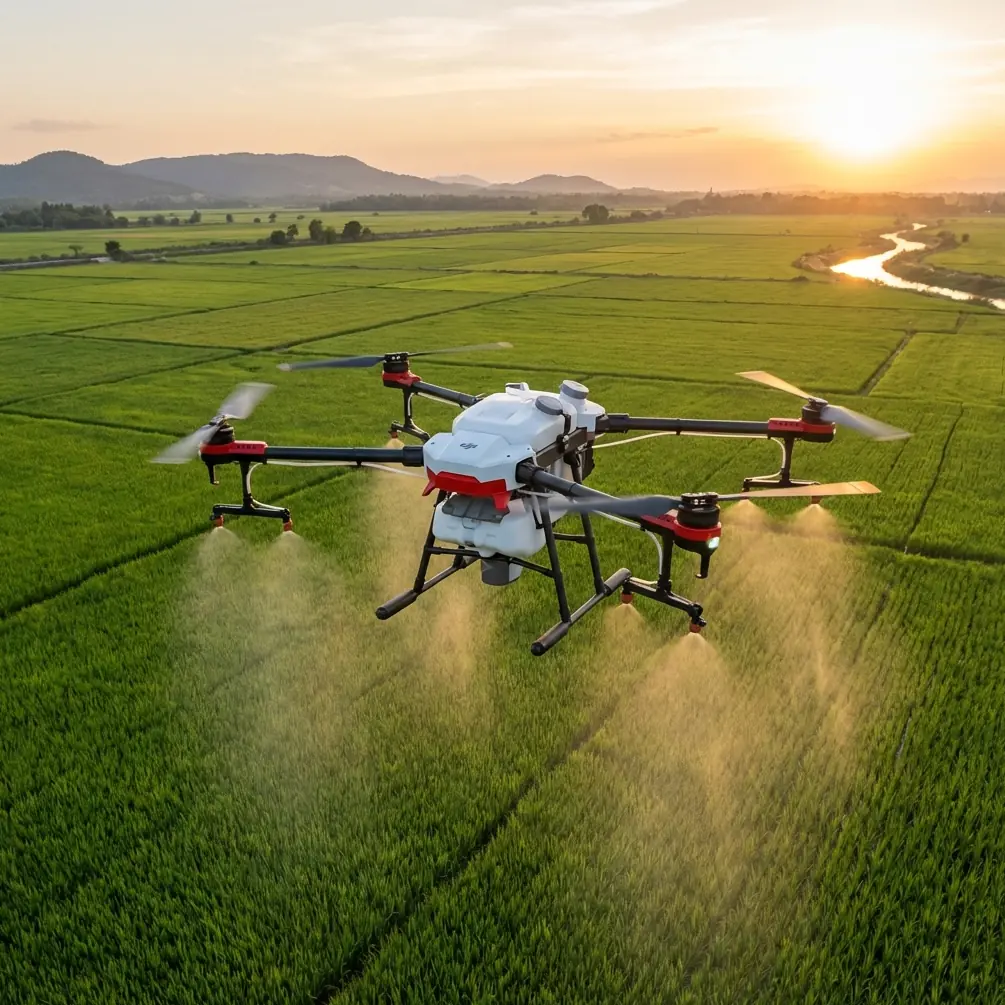
Agras T50 for Remote Vineyard Monitoring: What Actually Matters in the Field
META: A field-focused tutorial on using the Agras T50 for remote vineyard monitoring, with practical insight on low-altitude navigation, high-resolution data capture, RTK workflow, nozzle calibration, and rugged operation.
Remote vineyards expose every weak point in a drone workflow.
Distance from roads slows down inspections. Terrain breaks line of sight. Patchy connectivity makes live coordination harder than it should be. And if a grower is trying to monitor canopy health, irrigation issues, slope runoff, or spray consistency across scattered blocks, the real bottleneck usually is not the aircraft alone. It is the whole chain: navigation, image quality, data timing, and the ability to operate reliably when access is poor.
That is why the Agras T50 becomes more interesting when you stop looking at it as only a spray platform and start thinking about it as part of a low-altitude operating system for remote agriculture.
A recent signal from Anhui makes that point clearer. The low-altitude flight navigation project led by 安徽省通航控股集团 was selected for a provincial science and technology innovation plan, placing it inside a key provincial-level research effort. That detail matters beyond policy headlines. For operators in remote vineyard environments, low-altitude navigation is not an abstract topic. It is the difference between repeatable routes and guesswork, between clean coverage and missed rows, between useful records and fragmented field notes.
Why remote vineyard monitoring is really a navigation problem first
Growers often describe vineyard monitoring as an imaging task. In practice, it starts with navigation.
Vineyards in mountainous or isolated areas create a very specific operational profile: narrow working corridors, repeated passes, elevation changes, and frequent obstacles at the edge of the block. If the aircraft cannot hold a stable low-altitude path and maintain consistent positioning, every downstream result suffers. Swath width becomes less reliable. Spray drift risk can increase if height control varies. Image overlap degrades. Comparing one flight to the next becomes less meaningful because the path itself changed.
This is where the broader low-altitude navigation push referenced in the Anhui project becomes operationally significant. Being included in a provincial-level innovation program shows that low-altitude navigation is being treated as infrastructure, not just as a feature. For Agras T50 users, especially those working in remote vineyards, that aligns with the real-world need for dependable route execution close to the crop.
In other words, the aircraft’s value is amplified when the airspace layer beneath it becomes more structured and more precise.
The T50 is strongest when paired with a monitoring mindset
The Agras T50 is widely discussed for application work, but remote vineyards need more than chemical delivery. They need observation that leads to action.
The most relevant technical reference in the source material is the discussion of low-altitude UAV remote sensing in surveying and mapping. That document highlights several traits of drone remote sensing systems: strong real-time performance, flexible deployment, high image resolution, and relatively low operating cost. It also emphasizes that these systems can work in hazardous or hard-to-access areas and quickly provide data for planning and decision-making.
That reads almost like a profile of the remote vineyard problem.
A vineyard on steep ground or in a road-poor zone may not be hazardous in the disaster-response sense, but it shares the same logistical challenge: people cannot inspect everything fast enough on foot, and conventional survey routines often arrive too late to support timely decisions. By contrast, a low-altitude drone mission can collect high-resolution imagery over a block in a short time, helping the operator identify canopy variability, erosion channels, standing water, and edge effects from roads or adjacent land use.
The source document makes another point that deserves attention: low-altitude UAV imaging can clearly distinguish vegetation, hydrology, and the scope of human activity impacts. For vineyard managers, that translates directly into practical monitoring categories:
- canopy uniformity and gaps in vegetative growth
- irrigation distribution and water stress indicators visible in patterns
- runoff movement after rain events
- changes at the margins of the property
- access road deterioration that may affect logistics
Those are not nice extras. In remote production zones, they shape labor scheduling, input timing, and risk management.
A practical tutorial workflow for the Agras T50 in remote vineyards
If I were setting up an Agras T50 workflow for vineyard monitoring in isolated terrain, I would avoid overcomplicating it. The best systems are repeatable.
1. Build the mission around repeatability, not one-off coverage
Start by mapping vineyard blocks into flight units that reflect terrain and row direction rather than administrative field boundaries. A remote block may look simple on paper but behave like three separate flight environments once slope, wind exposure, and takeoff access are factored in.
This is where centimeter precision matters. If your RTK fix rate is unstable, repeat monitoring loses value because small positional shifts can masquerade as crop change. A consistent RTK workflow gives you cleaner comparisons over time, especially when assessing row-to-row anomalies or checking whether a suspected issue is expanding.
For remote vineyards, that consistency also reduces pilot workload. You spend less time correcting for drift and more time observing what the crop is telling you.
2. Calibrate nozzles as if monitoring depends on it, because it does
Many operators separate spraying from monitoring. They should not.
Nozzle calibration directly affects the interpretability of field results after treatment. If droplet output is uneven, the visual and agronomic patterns you observe later may reflect equipment inconsistency rather than biological reality. In vineyards, where row spacing, canopy density, and wind corridors can vary within a single property, poor calibration muddies the evidence.
This is also where spray drift belongs in the conversation. Remote sites often feel forgiving because there are fewer nearby buildings or roads. That can create false confidence. Valleys funnel wind. Ridge lines create turbulence. Uneven height above canopy changes deposition behavior. Monitoring flights should be used to identify where drift risk is structurally higher, not just where it was visible after the fact.
A disciplined T50 operator treats monitoring data as a feedback loop into nozzle setup, route design, and speed selection.
3. Use low-altitude imagery for decisions, not archives
The source document stresses that drones can provide high-resolution image data quickly and support more scientific planning and decision-making. That only happens if every mission has a question behind it.
For vineyards, useful monitoring questions include:
- Which rows are lagging and need ground verification?
- Where is canopy vigor deviating from the historical pattern?
- Is drainage behaving differently after infrastructure work?
- Are headlands showing compaction or runoff stress?
- Did the previous spray mission produce a pattern that suggests undercoverage?
Without a decision target, imagery becomes digital clutter.
In remote properties, speed matters because travel time amplifies every delay. A field team that waits several days to process and interpret data loses one of the main advantages of low-altitude UAV operations: timely intervention.
4. Consider a third-party multispectral payload workflow
The prompt around multispectral capability is well chosen. In remote vineyards, visible imagery alone may not be enough, particularly when mild stress is not obvious to the eye. A third-party multispectral accessory or integrated companion workflow can extend what the T50 contributes by making vigor differences clearer across complex terrain.
That enhancement is especially useful where blocks are spread out and agronomists cannot walk every section frequently. A multispectral layer can help prioritize where to send boots on the ground first. It does not replace field inspection, but it makes field inspection more intelligent.
This is a good example of capability enhancement that is not about adding complexity for its own sake. It is about shortening the route from aerial observation to agronomic action.
Why ruggedness matters more in vineyards than spec sheets suggest
Remote vineyards are hard on equipment. Dust from access roads, moisture around irrigation infrastructure, and frequent loading cycles all punish weak hardware.
That is where an IPX6K-level durability reference becomes meaningful in practical terms. Operators do not need ruggedization for bragging rights. They need it because cleaning, transport, and unpredictable field conditions are part of normal vineyard work. Reliability in that setting reduces aborted missions and preserves data continuity across the season.
A monitoring routine only becomes valuable when it is sustained. One excellent flight in May does not solve anything if the system becomes too cumbersome or fragile to deploy weekly through the season.
The hidden connection between surveying logic and agricultural drone work
One of the strongest insights in the source material is that low-altitude UAV remote sensing has advanced across design, flight control, data transmission, information acquisition, manufacturing, and broad application. That progression helps explain why aircraft like the Agras T50 are no longer confined to a single role.
Agriculture has borrowed heavily from surveying logic, even when users do not describe it that way.
Remote vineyard monitoring depends on the same fundamentals that made low-altitude UAVs valuable in mapping and environmental observation:
- precise path control
- reliable data capture
- quick deployment in hard-to-reach locations
- imagery with enough resolution to support decisions
- efficient turnaround from field collection to action
The source text also notes that demand for mapping is increasing across industries and that low-altitude UAV imaging is a key way to provide timely geospatial information for planning and construction. In agriculture, especially in specialty crops like vineyards, that same principle applies at a smaller scale. The map is not just a map. It becomes a management surface.
That is why serious T50 workflows in vineyards should not isolate application from observation. The strongest operators use both.
A realistic field scenario
Imagine a remote vineyard block after a period of uneven rainfall.
Ground crews suspect that one upper section is drying faster while a lower terrace is holding moisture. A standard scouting walk would take hours and still miss pattern-level context. A T50-based monitoring mission flown on a repeatable route with stable RTK positioning can produce high-resolution coverage quickly. If paired with a multispectral accessory workflow, the operator can flag subtle vigor differences before visual symptoms become obvious across the entire slope.
Then the same operational framework informs the next treatment cycle. Nozzle calibration is checked against canopy density zones. Flight height is adjusted to reduce drift exposure along a wind-prone edge. Swath width is evaluated against row geometry rather than assumed from a flat-field template.
That is what mature drone use looks like in vineyards: not isolated flights, but a connected sequence of observation, interpretation, and execution.
The broader industry signal behind the T50 use case
The Anhui low-altitude navigation project and the remote sensing reference document point in the same direction.
First, low-altitude navigation is becoming a formal innovation priority. Second, UAV remote sensing has already proven its worth where access is poor, response time matters, and high-resolution data improves decisions. Remote vineyards sit directly inside that overlap.
This matters for readers researching the Agras T50 because the question is no longer whether an agricultural drone can fly a vineyard. The better question is whether your operation is organized to benefit from what low-altitude systems now make possible.
If the answer is yes, the T50 can become far more than a task machine. It becomes a field intelligence node.
A few implementation notes that separate average results from good ones
For remote vineyard teams, I would keep five points front and center:
Protect route consistency.
If one monitoring mission is not comparable to the next, trend analysis weakens fast.
Track RTK behavior, not just mission completion.
A completed flight with poor fix stability can generate misleading confidence.
Treat nozzle calibration as part of data quality.
Application inconsistency distorts what later monitoring appears to show.
Use multispectral selectively.
Deploy it where stress differentiation or prioritization of scouting effort really matters.
Design for field endurance.
Rugged hardware, simple workflows, and reliable data handling matter more in remote sites than lab-perfect feature sets.
If you need help shaping a remote-vineyard T50 workflow around navigation, monitoring, or accessory selection, this direct WhatsApp line can be useful for technical discussion: https://wa.me/85255379740
The Agras T50 makes the most sense in remote vineyard monitoring when you frame it inside the real demands of low-altitude work: precision close to the canopy, high-resolution observation, dependable route repeatability, and useful data fast enough to change what happens next in the field. The policy push into low-altitude navigation and the proven strengths of UAV remote sensing in hard-to-access environments both reinforce the same conclusion: the aircraft matters, but the operating system around it matters just as much.
Ready for your own Agras T50? Contact our team for expert consultation.