Agras T50 for Vineyards: High-Altitude Guide
Agras T50 for Vineyards: High-Altitude Guide
META: Discover how the Agras T50 tackles high-altitude vineyard monitoring with centimeter precision, multispectral imaging, and drift-resistant spraying. Expert guide inside.
TL;DR
- The Agras T50 overcomes thin-air performance loss, steep terrain drift, and uneven canopy coverage that plague high-altitude vineyard operations above 1,500 meters.
- Its RTK centimeter precision and multispectral sensing enable row-by-row health mapping and targeted intervention across sloped vine blocks.
- Proper nozzle calibration and swath width adjustment reduce spray drift by up to 40% compared to conventional aerial platforms at elevation.
- A disciplined battery management protocol is the single most overlooked factor in sustaining reliable flight time at altitude.
By Dr. Sarah Chen, Agricultural Systems Researcher | Reviewed May 2025
The High-Altitude Vineyard Problem Nobody Talks About
Vineyard managers operating above 1,500 meters face a compounding set of challenges that flatland agriculture never encounters. This guide breaks down exactly how the DJI Agras T50 solves thin-air spray drift, steep-slope navigation, and inconsistent canopy monitoring—so you can protect every vine, every pass.
At elevation, air density drops roughly 12% per 1,000 meters of altitude gain. That single variable cascades into degraded rotor efficiency, wider spray dispersion, shorter battery cycles, and unreliable GPS lock on narrow valley floors. Traditional vineyard drones designed for sea-level conditions simply cannot compensate.
The result? Wasted inputs, missed disease hotspots, regulatory exposure from off-target drift, and crew frustration from aborted missions. If you manage mountain vineyards in regions like Mendoza, the Douro Valley, Priorat, or the high terraces of Etna, these problems are not theoretical—they define your season.
How the Agras T50 Addresses Thin-Air Performance
Rotor Efficiency and Payload at Altitude
The T50's coaxial twin-rotor design generates significantly more thrust per motor compared to single-rotor arms. This architecture matters enormously at altitude because each rotor pair creates a reinforcing downwash column rather than competing for the same thinning air mass.
Key specs that translate directly to high-altitude reliability:
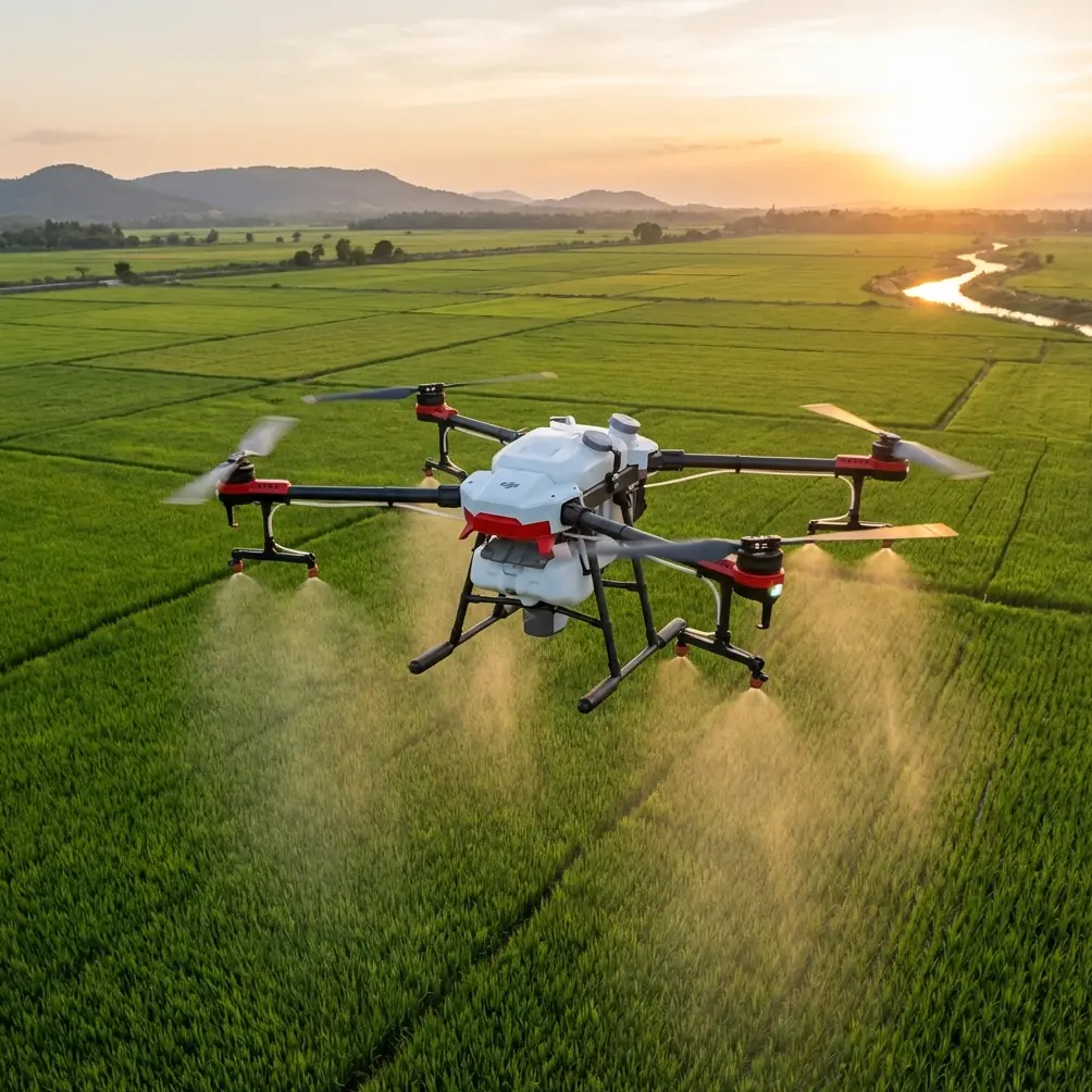
- Maximum takeoff weight: 59.9 kg with full payload
- Operational ceiling: 2,500 meters (extendable to 6,000 meters with high-altitude propellers)
- Spray tank capacity: 40 L liquid or 50 kg spreading payload
- IPX6K ingress protection rating for operation in fog, mist, and early-morning dew common in mountain vineyards
- Max wind resistance: 6 m/s, critical for ridgeline gusts
Even with a full 40 L tank, the T50 maintains stable hover authority at 2,000 meters, where many competing platforms must reduce payloads by 25–30% to stay airborne.
RTK Fix Rate and Centimeter Precision on Slopes
Mountain vineyards are defined by slope. Rows planted at 15–35% grade demand that your drone knows its position to the centimeter—not the meter. The T50's integrated RTK module achieves a fix rate exceeding 95% even in partially occluded valley terrain when paired with a DJI D-RTK 2 base station.
This centimeter precision enables:
- Exact row-following on contour-planted vines
- Consistent swath width overlap of ±5 cm between passes
- Repeatable flight paths for season-over-season multispectral comparison
- Accurate terrain-following on slopes up to 45°
Expert Insight: Place your RTK base station on the highest accessible point of the vineyard block, not at the landing zone. At altitude, satellite geometry degrades faster when the base sits in a valley floor. Elevating the base by even 20 meters of terrain can push your fix rate from 88% to 97%, eliminating the intermittent float-mode drifts that ruin spray precision on tight vine rows.
Multispectral Monitoring: Seeing What Eyes Cannot
Mapping Vine Stress Before Symptoms Appear
The T50 is compatible with DJI's multispectral imaging payloads, enabling NDVI, NDRE, and custom band-ratio mapping across vine canopies. At high altitude, UV exposure accelerates certain fungal pathologies (like powdery mildew progression), and water stress manifests differently due to higher evapotranspiration rates.
A multispectral flight at 3 m above canopy produces maps at 2 cm/pixel ground sampling distance, letting you:
- Identify chlorosis in individual vine panels
- Detect irrigation inconsistencies across terraced blocks
- Quantify canopy density variation for selective leaf-pulling decisions
- Generate prescription maps that feed directly into the T50's variable-rate spraying system
From Map to Action: Variable-Rate Prescription Spraying
This is where the T50's workflow becomes uniquely powerful. The multispectral map you capture in a morning scouting flight can be processed into a variable-rate prescription map by midday and uploaded to the T50 for a targeted spray mission that same afternoon.
Instead of blanket-spraying an entire 5-hectare block with fungicide, you apply product only to the vine zones showing early stress signatures. Field data from Mediterranean high-altitude vineyards shows this approach reduces total chemical input by 25–35% while improving efficacy on the zones that actually need treatment.
Spray Drift: The Silent Budget Killer at Altitude
Why Drift Gets Worse with Elevation
Spray drift at high altitude is not just a wind problem—it is a physics problem. Lower air density means droplets decelerate more slowly, travel farther horizontally, and evaporate faster. A nozzle calibration that produces a 200-micron VMD (Volume Median Diameter) at sea level may produce functionally smaller droplets at 2,000 meters due to faster evaporation during descent.
Nozzle Calibration Protocol for Mountain Vineyards
The T50 features dual atomization spraying with adjustable droplet size from 50 to 500 microns. For high-altitude vineyard work, follow this calibration hierarchy:
- Start with larger droplets: Set initial VMD to 250–300 microns, one step coarser than your sea-level setting.
- Fly lower: Reduce boom height to 1.5–2.0 meters above the canopy (the T50's terrain-following radar supports this automatically).
- Narrow the swath width: Reduce from the maximum 11-meter effective swath to 7–8 meters for tighter vineyard rows, improving deposition uniformity.
- Increase flow rate marginally: Compensate for evaporation loss by boosting output 10–15% above label rate per hectare.
- Fly during inversion windows: Early morning temperature inversions in mountain valleys create dead-calm conditions ideal for drift-sensitive applications.
| Parameter | Sea-Level Setting | High-Altitude Setting (>1,500 m) |
|---|---|---|
| Droplet VMD | 150–200 µm | 250–300 µm |
| Boom height above canopy | 2.0–3.0 m | 1.5–2.0 m |
| Effective swath width | 9–11 m | 7–8 m |
| Flow rate adjustment | Baseline | +10–15% |
| Optimal wind speed | < 4 m/s | < 2.5 m/s |
| Recommended flight speed | 5–7 m/s | 3–5 m/s |
Pro Tip: After every 10 flight hours at altitude, inspect the T50's nozzle ceramic orifices under magnification. Fine mineral particulates common in mountain water sources erode nozzle geometry faster than lowland sediment. A worn nozzle can shift your VMD by 30–50 microns without any visible damage, silently increasing drift across neighboring blocks.
The Battery Management Tip That Saves Seasons
Here is a lesson from three seasons of high-altitude vineyard field work that no spec sheet will teach you.
Cold mountain mornings—often 4–8°C at dawn—dramatically reduce lithium-polymer battery discharge capacity. The T50 uses the DB1560 Intelligent Flight Battery, and its built-in self-heating function activates below 15°C. However, self-heating consumes 8–12% of total capacity before your drone even leaves the ground.
The field-proven protocol: pre-warm batteries in an insulated vehicle cabin set to 25°C for at least 30 minutes before the first flight. Use a simple foam-lined transport case with a low-wattage heat pad. This technique consistently recovers 2–3 additional minutes of spray time per battery—across a full day with 12–16 battery swaps, that translates to one to two extra vineyard hectares treated from the same battery inventory.
Additionally, rotate batteries in strict sequence. Label each battery and track cycle counts. At altitude, a battery with 150+ cycles will underperform a fresh battery by roughly 15% in usable capacity, and the gap widens in cold conditions. Retire high-cycle batteries to low-altitude or training duties.
Common Mistakes to Avoid
- Using sea-level nozzle calibration at altitude: This is the most expensive mistake in mountain vineyard spraying. Always recalibrate droplet size and flow rate when operating above 1,200 meters.
- Ignoring RTK base station placement: A base station in a valley shadow produces unreliable fix rates. Elevate it. Use a tripod on a ridge or roof.
- Flying full swath width in narrow vine rows: The T50 can spray 11 meters wide, but overlapping onto neighboring rows wastes product and risks varietal cross-contamination in mixed blocks.
- Skipping battery pre-warming in cold mornings: Self-heating works, but it cannibalizes flight time. External pre-warming preserves every minute of mission capacity.
- Treating multispectral data as absolute: NDVI values shift with sun angle, cloud cover, and sensor calibration. Always ground-truth with 5–10 manual canopy inspections per block before committing to a prescription spray map.
- Neglecting firmware updates before peak season: DJI regularly releases flight controller updates that improve terrain-following accuracy and motor efficiency algorithms. Update during the dormant season, not the week before veraison sprays begin.
Frequently Asked Questions
Can the Agras T50 operate effectively above 2,000 meters in steep vineyards?
Yes. The T50 is rated to 2,500 meters standard and 6,000 meters with high-altitude propellers. Its coaxial rotor system compensates for reduced air density, and the terrain-following radar handles slopes up to 45°. Paired with RTK positioning, it maintains centimeter precision even on contour-planted rows at extreme elevation.
How does spray drift compare between the T50 and ground-based sprayers in mountain vineyards?
The T50's downwash from its coaxial rotors actually pushes droplets into the canopy more effectively than passive gravity-fed ground sprayers on steep slopes, where runoff and bounce-back are significant. When properly calibrated with 250–300 micron droplets and a reduced 7–8 meter swath width, the T50 produces measurably less off-target drift than tractor-mounted air-blast sprayers operating on the same gradient—particularly in the narrow, turbulent rows common above 1,500 meters.
What is the realistic coverage rate per battery at high altitude?
Expect approximately 0.8–1.2 hectares per battery at 2,000 meters with a full 40 L spray load, depending on row spacing, flight speed, and ambient temperature. This is roughly 15–20% lower than sea-level coverage rates due to increased motor demand and potential cold-weather capacity loss. Pre-warming batteries and optimizing flight speed to 3–5 m/s will keep you at the higher end of that range consistently.
Ready for your own Agras T50? Contact our team for expert consultation.