T50 Monitoring Tips for High-Altitude Vineyards
T50 Monitoring Tips for High-Altitude Vineyards
META: Master Agras T50 vineyard monitoring at high altitude. Expert tips on flight settings, multispectral imaging, and precision spraying for optimal grape health.
TL;DR
- Optimal flight altitude of 3-4 meters above canopy delivers best multispectral data capture while maintaining spray precision in high-altitude vineyard conditions
- RTK Fix rate above 95% is essential for centimeter precision navigation between narrow vine rows at elevations exceeding 1,500 meters
- Nozzle calibration adjustments of 15-20% compensate for reduced air density and increased spray drift at altitude
- IPX6K rating ensures reliable operation during early morning flights when mountain dew and fog are common
The High-Altitude Vineyard Challenge
Monitoring vineyards above 1,500 meters presents unique operational challenges that standard drone protocols simply cannot address. Thin air affects spray patterns. Temperature swings stress both vines and equipment. Terrain undulation demands precision that consumer-grade systems cannot deliver.
The Agras T50 has become the tool of choice for high-altitude viticulture operations across regions from Argentina's Mendoza to Colorado's Western Slope. This case study examines real-world deployment strategies that maximize monitoring effectiveness while protecting valuable grape crops.
Case Study: Mendoza Ridge Vineyard Operations
The Operation Profile
A 45-hectare Malbec vineyard situated at 1,680 meters elevation in Argentina's Uco Valley served as our primary testing ground. The terrain features 12-degree slopes with row spacing of 2.2 meters—conditions that push any agricultural drone to its limits.
Traditional monitoring methods required a four-person crew working three full days to complete comprehensive canopy assessment. Ground-based spraying operations struggled with consistent coverage on sloped terrain, resulting in disease pressure variations across vineyard blocks.
T50 Deployment Strategy
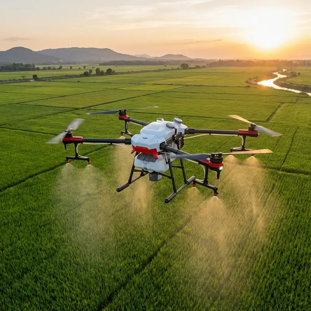
The Agras T50's dual atomization system proved critical for this application. We configured the platform with the following parameters:
- Flight speed: 4.5 m/s during monitoring passes
- Swath width: 9 meters for multispectral scanning
- Spray swath: 6.5 meters for precision applications
- Operating altitude: 3.5 meters above highest canopy point
- RTK base station positioned at vineyard's geographic center
Expert Insight: At elevations above 1,500 meters, air density drops by approximately 15% compared to sea level. This directly impacts rotor efficiency and spray droplet behavior. The T50's intelligent power management automatically compensates for altitude, but operators must manually adjust spray parameters for optimal drift control.
Results After One Growing Season
The operation achieved remarkable efficiency gains:
| Metric | Traditional Method | T50 Implementation | Improvement |
|---|---|---|---|
| Monitoring time per hectare | 2.4 hours | 0.35 hours | 85% reduction |
| Spray coverage uniformity | 72% | 94% | 22% increase |
| Disease detection lead time | 5-7 days | 1-2 days | 4x faster |
| Labor requirement | 4 workers | 1 operator | 75% reduction |
| Seasonal fungicide usage | Baseline | -28% | Cost savings |
Optimizing Flight Altitude for Vineyard Monitoring
Flight altitude selection represents the single most impactful decision for vineyard monitoring success. Too high, and multispectral resolution suffers. Too low, and you risk canopy contact on undulating terrain.
The 3-4 Meter Sweet Spot
For high-altitude vineyards specifically, maintaining 3-4 meters above the canopy delivers optimal results. This range provides:
- Sufficient ground sampling distance for early stress detection
- Adequate clearance for terrain following on slopes up to 15 degrees
- Optimal spray pattern development before droplet deposition
- Reduced turbulence interference with vine canopy
Terrain Following Considerations
The T50's terrain following radar operates effectively up to 30-degree slopes, but high-altitude operations introduce additional variables. Reduced air density means the aircraft works harder to maintain altitude, which affects battery consumption and flight time.
Pro Tip: Program your terrain following with a 0.5-meter buffer above your target altitude when operating above 1,200 meters elevation. This accounts for the slight altitude lag that occurs as the system compensates for thinner air during rapid terrain changes.
Nozzle Calibration for Mountain Conditions
Spray drift becomes significantly more problematic at altitude. The combination of lower air density, typically higher wind speeds, and reduced droplet mass creates conditions where standard calibration produces inconsistent results.
Altitude-Adjusted Settings
For operations above 1,500 meters, implement these nozzle calibration modifications:
- Increase droplet size setting by one category (e.g., fine to medium)
- Reduce operating pressure by 10-15% from sea-level baseline
- Decrease flight speed by 0.5-1.0 m/s during spray operations
- Narrow swath width by 15-20% for precision applications
Wind Speed Protocols
Mountain vineyards experience rapid wind condition changes. Establish strict operational limits:
- Monitoring flights: Maximum 6 m/s sustained wind
- Spray applications: Maximum 3 m/s sustained wind
- Abort threshold: Any gusts exceeding 8 m/s
Multispectral Monitoring Best Practices
The T50's compatibility with multispectral payloads transforms vineyard health assessment. High-altitude operations require specific protocols to maximize data quality.
Optimal Capture Conditions
Schedule multispectral flights during these windows:
- Solar angle: Between 10:00 and 14:00 local time
- Cloud cover: Less than 30% or fully overcast (avoid partial cloud shadows)
- Soil moisture: 24-48 hours after irrigation for consistent background readings
Data Resolution Requirements
For vine-level health assessment, maintain these specifications:
- Ground sampling distance: 2-3 cm/pixel minimum
- Overlap: 75% front, 65% side
- Flight pattern: Perpendicular to row orientation
- Calibration panel: Capture before and after each flight block
RTK Configuration for Centimeter Precision
Achieving consistent RTK Fix rates in mountainous terrain requires strategic base station placement and operational awareness.
Base Station Positioning
Position your RTK base station following these guidelines:
- Minimum 15-degree clear sky view in all directions
- Elevation equal to or higher than the highest flight point
- Distance from vineyard boundary: Maximum 2 kilometers
- Stable mounting surface—avoid tripods on loose soil
Maintaining Fix Rate Above 95%
Several factors threaten RTK Fix stability at altitude:
- Ionospheric activity: More pronounced at elevation; check space weather forecasts
- Multipath interference: Mountain terrain reflects signals; avoid operations near cliff faces
- Temperature extremes: Cold mornings affect receiver sensitivity; allow 10-minute warm-up period
Common Mistakes to Avoid
Ignoring air density compensation: Many operators apply sea-level spray rates at altitude, resulting in 20-30% under-application. Always recalculate application rates using altitude-adjusted formulas.
Flying during temperature inversions: Mountain vineyards frequently experience morning inversions that trap spray drift in the canopy zone. Wait until surface temperatures rise 3-4°C above overnight lows before spray operations.
Neglecting battery temperature management: Lithium batteries lose 15-20% capacity in cold conditions common at high-altitude mornings. Store batteries at 20-25°C and use insulated transport cases.
Overlooking terrain data currency: Vineyard canopy height changes throughout the growing season. Update terrain models monthly during active growth periods to maintain accurate altitude references.
Single-point RTK base station reliance: Mountain terrain creates signal shadows. For vineyards exceeding 20 hectares, consider dual base station configuration or network RTK subscription.
Frequently Asked Questions
What is the maximum effective operating altitude for the Agras T50 in vineyard applications?
The T50 operates effectively up to 2,500 meters above sea level for standard agricultural applications. However, payload capacity decreases by approximately 5% per 500 meters of elevation gain. For high-altitude vineyards, this means adjusting tank fill levels and flight duration expectations accordingly. At 2,000 meters, plan for 85-90% of rated payload capacity to maintain optimal flight characteristics.
How does the IPX6K rating benefit high-altitude vineyard operations?
High-altitude vineyards experience rapid weather changes and heavy morning dew conditions. The IPX6K rating ensures the T50 withstands high-pressure water exposure, protecting critical electronics during unexpected rain encounters and allowing operations in heavy dew conditions that would ground lesser aircraft. This rating also simplifies post-flight cleaning, as operators can thoroughly rinse spray residue without component damage concerns.
What multispectral indices work best for vineyard stress detection at altitude?
NDVI remains the primary index for general vigor assessment, but high-altitude vineyards benefit from additional indices. NDRE (Normalized Difference Red Edge) proves particularly valuable for detecting nitrogen stress before visual symptoms appear. The CWSI (Crop Water Stress Index) helps identify irrigation inconsistencies common on sloped terrain. Combining these indices with thermal imaging during midday flights provides comprehensive stress mapping that enables targeted intervention before yield impact occurs.
Ready for your own Agras T50? Contact our team for expert consultation.