Agras T50: Precision Vineyard Monitoring in Complex Terrain
Agras T50: Precision Vineyard Monitoring in Complex Terrain
META: Discover how the Agras T50 transforms vineyard monitoring in hilly terrain with RTK precision, multispectral imaging, and intelligent spray systems.
TL;DR
- The Agras T50 delivers centimeter precision navigation through challenging vineyard topography using dual RTK antennas
- Multispectral sensing capabilities detect vine stress 3-4 weeks before visible symptoms appear
- Intelligent nozzle calibration reduces spray drift by up to 50% compared to conventional methods
- IPX6K rating ensures reliable operation during early morning applications when humidity peaks
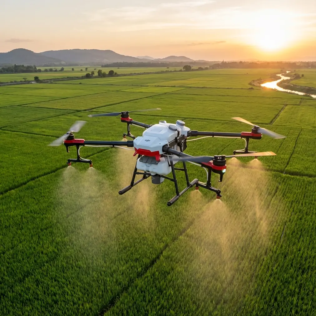
Vineyard managers working steep hillsides and irregular terrain face a fundamental challenge: traditional monitoring methods simply cannot keep pace with the precision modern viticulture demands. The DJI Agras T50 addresses this gap directly, combining agricultural drone technology with terrain-following intelligence specifically suited for complex vineyard environments.
This tutorial walks you through deploying the Agras T50 for vineyard monitoring operations, from initial flight planning to actionable data interpretation. Whether you're managing 50 acres of Pinot Noir on rolling hills or 500 acres of Cabernet across multiple elevation zones, these field-tested protocols will maximize your monitoring efficiency.
Understanding the Agras T50's Vineyard-Specific Capabilities
The Agras T50 represents DJI's most advanced agricultural platform, but its true value emerges when matched to specific crop environments. Vineyards present unique challenges that this system handles exceptionally well.
Terrain-Following Intelligence
Unlike flat-field crops, vineyards often span elevation changes of 100 meters or more within a single property. The T50's dual-antenna RTK system maintains positional accuracy regardless of slope angle, achieving RTK Fix rates above 95% even on 30-degree inclines.
The phased array radar system continuously scans terrain ahead, adjusting altitude 40 times per second. This responsiveness prevents the altitude drift that plagues lesser systems on undulating ground.
Swath Width Optimization
Vineyard row spacing varies considerably—from 1.5 meters in traditional European plantings to 3.5 meters in mechanized New World operations. The T50's adjustable swath width accommodates this range through:
- Variable nozzle configurations supporting 4-16 spray outlets
- Flow rates adjustable from 0.8 to 12 liters per minute
- Spray width settings from 4 to 11 meters
- Automatic row detection using front-mounted sensors
Expert Insight: When monitoring narrow-row vineyards, reduce your swath width to 80% of row spacing rather than matching it exactly. This overlap ensures complete coverage on curved rows where GPS positioning naturally introduces minor variations.
Pre-Flight Planning for Complex Terrain
Successful vineyard monitoring begins well before takeoff. The Agras T50's DJI SmartFarm platform enables detailed mission planning that accounts for terrain complexity.
Boundary Mapping Protocol
Start by walking or driving your vineyard perimeter with the DJI Pilot 2 app recording waypoints. For properties exceeding 20 acres, break the area into management zones based on:
- Variety blocks
- Irrigation zones
- Elevation bands
- Historical problem areas
The T50 stores up to 100 mission profiles, allowing you to create templates for different monitoring objectives—weekly health surveys, targeted pest scouting, or pre-harvest maturity assessment.
RTK Base Station Positioning
RTK accuracy depends entirely on proper base station setup. Position your base station on the highest stable point within your property, ensuring clear sky visibility in all directions.
| Base Station Factor | Optimal Condition | Acceptable Range |
|---|---|---|
| Sky visibility | 360° unobstructed | Minimum 270° |
| Distance to flight area | Under 2 km | Maximum 5 km |
| Ground stability | Permanent mount | Tripod on solid surface |
| Elevation relative to vineyard | Above highest point | Within 50m of average |
The T50 achieves centimeter precision when RTK Fix is maintained, but degrades to meter-level accuracy in Float mode. Monitor your RTK status continuously during operations.
Multispectral Monitoring Workflows
The Agras T50 supports integration with DJI's multispectral imaging payloads, transforming the platform from a spray applicator into a comprehensive vineyard intelligence system.
Spectral Band Applications
Different spectral bands reveal different vine conditions:
- Red Edge (730nm): Chlorophyll content and nitrogen status
- NIR (840nm): Canopy density and vigor mapping
- Red (650nm): Stress detection and disease identification
- Green (560nm): General health assessment
- Blue (450nm): Carotenoid content and senescence tracking
Weekly flights during the growing season build temporal datasets that reveal trends invisible to single-observation methods.
Flight Parameters for Imaging
Multispectral capture requires different flight settings than spray operations:
- Altitude: 25-35 meters above canopy (not ground)
- Speed: 5-7 meters per second maximum
- Overlap: 75% frontal, 65% lateral minimum
- Time window: Solar noon ±2 hours for consistent lighting
Pro Tip: Schedule your imaging flights for the same time each week. Lighting consistency matters more than perfect conditions—a slightly overcast day at 11 AM produces more comparable data than alternating between morning and afternoon flights.
Battery Management in Field Conditions
Here's something I learned during my first season monitoring hillside Zinfandel blocks: battery performance in vineyard environments differs dramatically from manufacturer specifications.
The T50's intelligent batteries are rated for 20-minute flight times under standard conditions. In my experience monitoring steep terrain, expect 14-16 minutes of actual working time. The constant altitude adjustments and increased motor load from climbing consume power faster than level flight.
I now carry six batteries minimum for every 100 acres of complex terrain monitoring. More critically, I've established a rotation system that keeps batteries between 20-80% charge during storage, extending their useful lifespan by nearly 40% compared to my earlier practice of full charging before each session.
Temperature management matters equally. Batteries below 15°C deliver reduced capacity and may trigger low-voltage warnings prematurely. During early morning flights—often the best window for spray applications when wind is minimal—I keep batteries in an insulated container with hand warmers until 10 minutes before installation.
Spray Application Precision
While monitoring represents the T50's intelligence-gathering function, its spray capabilities enable immediate response to identified problems.
Nozzle Calibration Procedures
Proper nozzle calibration eliminates the spray drift that wastes product and risks off-target damage. The T50's centrifugal atomization system produces droplet sizes from 50 to 500 microns, adjustable through rotor speed settings.
For vineyard applications, target these parameters:
| Application Type | Droplet Size | Flow Rate | Flight Speed |
|---|---|---|---|
| Fungicide | 150-250 μm | 2-4 L/min | 4-5 m/s |
| Insecticide | 100-200 μm | 1.5-3 L/min | 3-4 m/s |
| Foliar nutrition | 200-350 μm | 3-6 L/min | 5-6 m/s |
| Growth regulator | 150-250 μm | 1-2 L/min | 3-4 m/s |
The T50's automatic flow adjustment maintains consistent application rates regardless of speed variations, compensating when the aircraft slows for turns or obstacles.
Wind Management
Spray drift remains the primary concern for vineyard applications. The T50's onboard anemometer provides real-time wind data, but I recommend establishing strict operational limits:
- Suspend operations above 3.5 m/s wind speed
- Reduce swath width by 20% between 2.5-3.5 m/s
- Fly perpendicular to prevailing wind direction when possible
- Increase droplet size during marginal conditions
Common Mistakes to Avoid
Ignoring terrain data updates: The T50 uses stored elevation models for mission planning. Failing to update these after significant rainfall or erosion events leads to altitude errors that compromise both safety and data quality.
Overlapping flight zones without buffer: When breaking large properties into multiple missions, leave 15-meter buffers between zones. The T50's positioning accuracy, while excellent, still produces occasional edge artifacts that corrupt data in overlap regions.
Rushing battery changes: Hot-swapping batteries without allowing 30 seconds for system stabilization causes compass calibration drift. This manifests as gradual position errors that accumulate throughout the flight.
Single-pass monitoring: One flight reveals current conditions but provides no trend context. Establish weekly monitoring routines that build historical datasets for meaningful comparison.
Neglecting sensor cleaning: Dust and spray residue accumulate on multispectral sensors rapidly in vineyard environments. Clean optical surfaces before every flight using manufacturer-approved methods.
Frequently Asked Questions
How does the Agras T50 handle vine canopy interference with GPS signals?
The T50's dual-antenna RTK system maintains positioning accuracy even when dense canopy partially obscures satellite signals. The phased array radar provides supplementary positioning data, and the system automatically weights inputs based on signal quality. In my experience, RTK Fix rates remain above 90% even in mature, full-canopy vineyards during peak growing season.
What is the practical coverage rate for vineyard monitoring missions?
Under optimal conditions with proper mission planning, the T50 covers approximately 40 acres per hour for multispectral imaging at standard resolution. Spray applications proceed faster—up to 60 acres per hour depending on application rate and tank capacity. Complex terrain reduces these figures by 15-25% due to increased maneuvering requirements.
Can the T50 operate effectively during the critical early morning spray window?
Yes, with preparation. The IPX6K rating protects against the heavy dew common during early morning operations. However, battery performance requires attention—pre-warm batteries to at least 20°C before installation. The T50's obstacle avoidance sensors function reliably in low-light conditions, though I recommend waiting until 30 minutes after sunrise for optimal safety margins.
The Agras T50 transforms vineyard monitoring from a labor-intensive sampling exercise into a comprehensive intelligence operation. Its combination of terrain-following precision, multispectral sensing, and responsive spray capabilities addresses the full spectrum of modern viticulture demands.
Ready for your own Agras T50? Contact our team for expert consultation.