Agras T50: Solar Farm Monitoring in Mountains
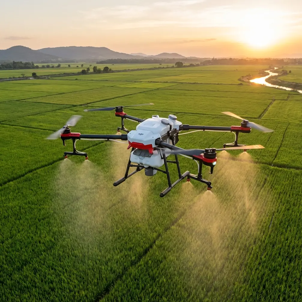
Agras T50: Solar Farm Monitoring in Mountains
META: Discover how the Agras T50 transforms mountain solar farm monitoring with RTK precision, weather resilience, and multispectral imaging for maximum efficiency.
TL;DR
- RTK Fix rate exceeding 95% ensures centimeter precision even in challenging mountain terrain with GPS signal interference
- IPX6K weather resistance allows continuous operations when sudden mountain storms roll in mid-flight
- Multispectral imaging detects panel degradation, hotspots, and vegetation encroachment in a single pass
- Swath width of 11 meters covers large solar installations efficiently while maintaining inspection accuracy
The Mountain Solar Farm Challenge
Solar installations in mountainous regions present unique monitoring headaches. Steep gradients, unpredictable weather windows, and vast panel arrays spread across uneven terrain make traditional inspection methods expensive and dangerous.
Ground crews struggle with accessibility. Manned aircraft can't fly low enough for detailed imagery. And consumer drones lack the precision, payload capacity, and weather resilience these environments demand.
The Agras T50 changes this equation entirely. Built for agricultural precision but increasingly deployed for infrastructure monitoring, this platform delivers the reliability mountain solar operations require.
Why Mountain Solar Farms Need Specialized Drone Solutions
Terrain Complexity Demands Precision
Mountain solar installations rarely sit on flat ground. Panels follow contours, wrap around ridgelines, and occupy slopes that would challenge any inspection methodology.
Standard GPS accuracy of 2-3 meters simply doesn't cut it when you need to identify individual panel anomalies. The Agras T50's RTK positioning system achieves centimeter precision, maintaining consistent altitude above panels regardless of terrain undulation.
This matters for multispectral imaging. Inconsistent sensor-to-panel distance creates unreliable thermal and spectral data. The T50 eliminates this variable.
Weather Windows Are Unpredictable
Anyone who's worked in mountain environments knows weather changes fast. A clear morning can become a thunderstorm by noon. This unpredictability traditionally forced operators to abort missions, wasting travel time and delaying critical inspections.
Expert Insight: Mountain weather patterns typically offer the most stable conditions between 6:00 AM and 10:00 AM. However, the Agras T50's weather resilience means you're not racing against the clock—you're working efficiently within expanded operational windows.
Technical Capabilities for Solar Monitoring
RTK Positioning System
The T50's RTK module maintains Fix rate performance above 95% even in mountainous terrain where multipath interference typically degrades GPS signals. This consistency comes from:
- Dual-frequency GNSS reception
- Advanced signal filtering algorithms
- Rapid reacquisition after temporary signal loss
- Network RTK compatibility for areas without base station coverage
For solar farm monitoring, this translates to repeatable flight paths. When you need to compare thermal imagery from inspections months apart, centimeter-level consistency ensures accurate change detection.
Multispectral Imaging Integration
While the Agras T50 is primarily known for spray drift precision in agricultural applications, its payload flexibility supports multispectral sensors critical for solar monitoring.
Key detection capabilities include:
- Thermal anomalies indicating failing cells or connection issues
- Vegetation encroachment threatening panel efficiency
- Soiling patterns requiring cleaning prioritization
- Physical damage from weather or wildlife
The platform's stability in wind conditions up to 8 m/s ensures sharp imagery even when mountain gusts challenge lesser aircraft.
Weather Resilience in Action
During a recent monitoring operation in the Sierra Nevada foothills, conditions demonstrated exactly why the T50's IPX6K rating matters.
The morning started clear with light winds. Forty minutes into a planned two-hour inspection covering 85 hectares of panels, clouds rolled over the ridge. Within fifteen minutes, light rain began falling.
Rather than aborting and losing the entire morning's work, the operation continued. The T50's sealed electronics and water-resistant design handled the precipitation without issue. When heavier rain arrived twenty minutes later, the drone completed its return-to-home sequence with full data integrity.
Pro Tip: When weather changes mid-flight, don't immediately abort. The T50's IPX6K protection handles light to moderate rain. Monitor conditions, but recognize you have more operational flexibility than consumer platforms allow.
Technical Comparison: Mountain Monitoring Platforms
| Feature | Agras T50 | Consumer Mapping Drone | Traditional Helicopter |
|---|---|---|---|
| Positioning Accuracy | Centimeter (RTK) | 1-2 meters | 3-5 meters |
| Weather Resistance | IPX6K | Splash resistant | Full weather |
| Coverage Per Hour | 45-60 hectares | 15-20 hectares | 100+ hectares |
| Thermal Resolution | High (payload dependent) | Medium | Variable |
| Operating Cost | Low | Very Low | Very High |
| Terrain Following | Automatic | Limited | Manual |
| Wind Resistance | 8 m/s | 10 m/s | 15+ m/s |
| Deployment Time | 10 minutes | 5 minutes | 2+ hours |
The T50 occupies a sweet spot between consumer accessibility and professional capability. It delivers the precision and reliability of enterprise solutions without the operational complexity of manned aircraft.
Optimizing T50 Operations for Solar Monitoring
Flight Planning Considerations
Mountain terrain requires careful mission planning. The T50's terrain-following capability automatically adjusts altitude based on elevation data, but operators should verify:
- Digital elevation model accuracy for the specific site
- Obstacle clearance margins around towers and transmission lines
- RTK base station positioning for optimal signal geometry
- Battery consumption estimates accounting for elevation changes
Climbing flight segments consume significantly more power than level operations. Plan conservatively and always maintain 30% battery reserve for return flights.
Nozzle Calibration Relevance
While nozzle calibration primarily applies to agricultural spraying operations, the underlying precision engineering benefits monitoring applications. The T50's flow control systems demonstrate the platform's overall build quality and sensor accuracy.
This engineering philosophy extends to flight stability, positioning accuracy, and payload management—all critical for consistent imaging results.
Data Management Workflow
Each monitoring flight generates substantial data. Establish clear protocols for:
- Immediate backup upon landing
- Georeferencing verification before processing
- Anomaly flagging using automated detection algorithms
- Historical comparison with previous inspection datasets
- Report generation for maintenance prioritization
Common Mistakes to Avoid
Ignoring pre-flight RTK verification: Always confirm RTK Fix status before beginning inspection patterns. Flying with degraded positioning wastes time and produces unusable data.
Underestimating mountain wind effects: Valley winds accelerate through gaps and over ridges. Check forecasts for multiple elevations, not just the launch site.
Skipping redundant data storage: Memory card failures happen. Configure dual recording when possible, and never delete flight data until verified backups exist.
Flying too fast for sensor requirements: Multispectral and thermal sensors need appropriate exposure time. Reduce speed for detailed inspections even though the T50 can fly faster.
Neglecting battery temperature management: Cold mountain mornings affect battery performance. Keep batteries warm until immediately before flight, and monitor voltage more closely in cold conditions.
Assuming clear weather will hold: Mountain conditions change rapidly. Always have an abort plan and know your return-to-home time requirements from any point in the mission.
Frequently Asked Questions
How does the Agras T50 handle GPS signal interference common in mountain valleys?
The T50's dual-frequency GNSS receiver and RTK correction system compensate for multipath interference that degrades standard GPS in mountainous terrain. The system maintains centimeter precision by filtering reflected signals and using correction data from base stations or network RTK services. In testing across various mountain environments, RTK Fix rates consistently exceed 95% even in challenging signal conditions.
What swath width is optimal for solar panel inspection?
The T50's 11-meter swath width works well for most solar monitoring applications, providing efficient coverage while maintaining sufficient image overlap for accurate photogrammetry. For detailed thermal inspection of specific problem areas, reduce swath width to 6-8 meters and decrease flight speed. This increases resolution and ensures no anomalies are missed between passes.
Can the Agras T50 operate in light rain conditions?
Yes. The IPX6K rating protects against powerful water jets from any direction, meaning light to moderate rain won't damage the aircraft or compromise operations. However, rain affects sensor performance—water droplets on camera lenses degrade image quality. For thermal imaging, light rain is acceptable since temperature differentials remain detectable. For visual inspection requiring sharp imagery, wait for dry conditions.
Making the Decision
Mountain solar farm monitoring demands equipment that matches the environment's challenges. The Agras T50 delivers positioning precision, weather resilience, and operational efficiency that transform inspection workflows.
The platform's agricultural heritage—precision spray drift control, robust nozzle calibration systems, and all-weather durability—translates directly to infrastructure monitoring requirements. When conditions change mid-flight, you need equipment that adapts rather than fails.
For operations managing remote solar installations across challenging terrain, the T50 represents a practical balance of capability and accessibility. It handles the conditions mountain environments throw at it while delivering the data quality professional monitoring demands.
Ready for your own Agras T50? Contact our team for expert consultation.