Agras T50 for Windy Highway Monitoring: A Technical Review
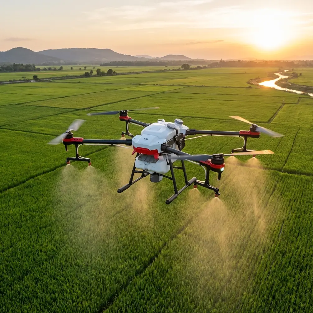
Agras T50 for Windy Highway Monitoring: A Technical Review Grounded in Risk, Data, and Corridor Operations
META: A technical review of the DJI Agras T50 for windy highway monitoring, focusing on flight data, operational risk, insurance implications, and corridor mapping logic.
Highway work creates a strange operating environment for drones. The corridor is long, narrow, exposed, and rarely forgiving. Wind funnels through cut slopes, overpasses interrupt signal geometry, embankments create turbulence, and the consequences of an off-nominal event are higher than in an open field. That is exactly why the Agras T50 deserves a more serious discussion than the usual spec-sheet treatment.
Most commentary around the T50 is framed around spraying efficiency. That misses the point for infrastructure readers. In a windy highway-monitoring scenario, the real question is not simply whether the aircraft can fly a route. The question is whether it can produce dependable, reviewable, and defensible operational data while working across irregular linear assets where safety exposure is visible and accountability matters.
That framing becomes even more relevant in light of a recent policy development in Chongqing: the city saw the first landing of what was described as a nationally pioneering mandatory drone liability insurance policy. That is not a side note. It signals where professional UAV operations are heading. As drone use expands into public-facing work near transport networks, insurance and post-flight traceability stop being administrative background noise and become part of mission design.
For anyone considering the Agras T50 for windy highway observation, vegetation management support, slope-condition review, or corridor documentation, the aircraft should be evaluated through three lenses: risk transfer, flight data quality, and suitability for long irregular routes.
Why highway monitoring is a harder test than field work
Agricultural environments and highways can look similar from altitude: both may involve repeated passes, changing terrain, and large operating areas. But the geometry is different. A farm block is a bounded polygon. A highway is a ribbon. That distinction matters.
A ribbon operation amplifies every weakness in positioning, route recovery, and environmental stability. The aircraft is repeatedly asked to maintain consistency over a long, narrow strip rather than simply cover an area. Wind changes do not average out as neatly. Small lateral deviations become meaningful when the operational target is a shoulder, median, drainage line, or slope edge rather than a broad crop canopy.
This is where the T50 has an advantage over lighter, less industrial platforms often pressed into corridor work. The more serious the aircraft, the more valuable its telemetry becomes. In windy monitoring missions, the platform is not just a flying camera or spraying machine. It is a sensor carrier that must tell you what happened during each second of the flight.
The overlooked issue: when something goes wrong, can you prove what happened?
A surprisingly useful reference point comes from educational drone training rather than a highway case study. A DJI TT teaching document on flight data explains a basic but operationally important fact: when a drone experiences an unexpected fault in outdoor beyond-visual-line conditions and loses flight capability, the aircraft may be recoverable physically, but determining the true cause depends on flight data.
That training material identifies several key data sources collected by onboard electronics, including the inertial measurement unit, TOF sensor, and barometric altitude sensor. Together, these systems record speed, acceleration, attitude angle, altitude, forward obstacle distance, and battery state. For professional operators, this is not abstract theory. It is the basis for incident reconstruction.
That matters for Agras T50 highway monitoring because windy corridors create exactly the kind of edge-case conditions where post-flight analysis becomes operationally significant. If the aircraft deviates near a guardrail line, aborts a leg, shows abnormal roll behavior over a bridge approach, or returns with a gap in a corridor pass, the ability to inspect flight data is what separates a disciplined operator from a guesswork operator.
The TT document gets specific enough to make the point concrete. It notes that roll-axis attitude can be tracked across a range from -179° to 179°. That kind of attitude information is not just for classroom instruction. In the real world, roll excursions in gusty conditions can reveal whether an aircraft was fighting crosswind loading, responding to uneven airflow near terrain, or behaving abnormally for another reason. In highway monitoring, where lateral stability matters, these data are operational evidence.
The T50’s value, then, is not only in what it carries or how much area it can treat. It lies in its fit within a professional workflow that expects every mission to be auditable.
Insurance is no longer separate from operations
The Chongqing insurance development should be read as a signal, not an isolated local headline. The first local landing of a mandatory drone liability policy, described as a national first, reflects an industry moving toward normalized accountability. Whenever drones operate near public infrastructure, roads, logistics corridors, or populated edges, liability structures tend to follow.
For T50 operators, this has two immediate implications.
First, aircraft selection is becoming inseparable from insurability. A platform used along highways must support disciplined operating procedures, clear maintenance routines, and recoverable data records. A heavier-duty operational profile without strong data habits can become difficult to defend after an incident.
Second, the mission itself should be documented with the assumption that third parties may someday review it. That means route planning, weather thresholds, battery management, and payload settings are not just technical details. They are part of the operator’s risk posture.
This is one reason the Agras T50 stands out versus consumer-adjacent alternatives that some teams still try to use for infrastructure-adjacent work. Competitors may be easier to deploy casually, but casual deployment is exactly the wrong instinct for a windy highway environment. When liability expectations rise, the better aircraft is often the one that fits a documented process, not merely the one that gets airborne fastest.
Corridor mapping lessons from mountain water conservancy apply directly to highways
Another reference source, a technical paper on UAV surveying for mountainous water conservancy mapping in Guizhou, offers a useful perspective that translates surprisingly well to road corridors.
The paper points out that traditional aerial photogrammetry has more than 100 years of history, while space photogrammetry has more than 50 years of development. Both are mature systems. Yet the authors argue they struggle with small-area, large-scale mapping tasks, especially where the target geometry is irregular. They discuss water conservancy projects stretching for dozens or even hundreds of kilometers in non-regular strips, with 1:2000 topographic maps identified as one of the earliest and most important data requirements.
Replace “water conservancy corridor” with “highway corridor,” and the logic barely changes.
Highway monitoring often involves the same operational shape problem: long, narrow, discontinuous areas requiring current, high-resolution data. Traditional archived imagery can be too old or too expensive to adapt. The Guizhou paper even notes that some available aerial photographs for certain regions dated back to 1969, creating a huge burden for updating and field verification. That detail may sound historical, but it captures a present-day truth: if source imagery is stale, corridor decisions degrade quickly.
For highway maintenance teams, slope-management contractors, and roadside vegetation programs, the Agras T50 enters this discussion as a platform for collecting fresh operational data where older topographic or visual records no longer match reality. Windy conditions do not remove that need; they increase it. A road corridor that has changed over the past three years through excavation, stabilization, drainage work, or vegetation growth demands current information, not inherited assumptions.
What the T50 does well in windy corridor work
The best way to understand the T50 in this role is to stop thinking about it as a generic drone and start thinking about it as a corridor platform.
Its edge over lighter competitors is not a single headline feature. It is the combination of industrial intent and route resilience. In windy environments, that combination shows up in several practical ways.
1. Better fit for repeatable strip operations
Highway monitoring is a repetition problem. You need the same edges covered, the same sections revisited, and the same anomalies compared over time. The T50 is better suited to repeated strip operations than smaller ad hoc platforms because it is built around professional agricultural workflows where consistency over large operating runs already matters. That operating DNA translates well to corridor missions.
If your team is monitoring verge encroachment, drainage obstruction, median vegetation, or exposed slope segments, repeatability matters more than flashy one-off captures.
2. Flight data supports decision-making, not just flying
This is where the educational flight-data reference becomes directly relevant. Telemetry such as speed, acceleration, altitude, obstacle distance, and battery state is not merely technical overhead. It tells you whether the mission quality is trustworthy.
If a section of highway appears under-documented, you need to know whether wind forced a compensation pattern, whether altitude fluctuated over terrain, or whether a battery-driven return altered corridor completeness. Operators who ignore these records are often blind to the quality of their own outputs.
3. It aligns with the future of regulated commercial drone work
The Chongqing insurance precedent matters here again. Infrastructure-adjacent UAV work is moving toward stronger formalization. In that environment, the T50 makes sense because it belongs in an operational culture where checklists, logs, traceability, and duty of care are normal. That is not glamorous, but it is exactly what keeps a corridor program viable.
Wind is not just a flight issue; it is a data-quality issue
Readers looking at the T50 for highway use often focus on whether the aircraft can “handle wind.” That question is too blunt. The better question is whether the aircraft can preserve mission usefulness when wind degrades ideal conditions.
For visual corridor review, wind can create uneven groundspeed, attitude correction, and route offset pressure. For spray-adjacent roadside vegetation management, wind also raises concerns around spray drift, nozzle calibration, and swath width consistency. Even if your main task is monitoring rather than application, those ideas still matter because they shape how accurately the aircraft can interact with linear roadside targets.
This is where a serious setup process separates the T50 from competitor deployments that look efficient only on paper. A professional operator should treat RTK fix rate, centimeter precision, and route integrity as mission-quality variables, not optional refinements. On a broad agricultural block, a slight inconsistency may be tolerable. Along a highway shoulder or drainage edge, it can translate into missed coverage or unusable comparison data.
A practical operating model for T50 highway missions
A sensible T50 workflow for windy highway monitoring would look less like generic drone flying and more like corridor asset management.
- Predefine segments rather than planning one oversized route.
- Establish wind thresholds tied to task type, not just legal minimums.
- Review attitude and speed logs after representative sorties.
- Confirm route continuity at transition points such as ramps, bridges, and cut slopes.
- Maintain payload settings that prioritize stability and data usefulness over brute throughput.
- Archive flights in a way that supports insurance, internal review, and trend comparison.
If your team is building or refining that workflow, a direct technical discussion is usually more useful than another feature summary. You can start that conversation here: message a T50 corridor specialist.
The real reason the Agras T50 stands out
The T50 excels not because it magically removes the difficulty of windy highway environments. No aircraft does. It stands out because it is easier to integrate into the kind of disciplined operation those environments require.
The references behind this review point to a larger pattern.
One source shows that the industry is entering a phase where drone liability is becoming formalized in places like Chongqing. Another shows that when aircraft fail or behave unexpectedly, flight data from IMU, TOF, and barometric systems is the only reliable path to understanding why. A third explains why long, irregular corridors are exactly where traditional mapping methods become inefficient or outdated, especially when current large-scale detail is needed.
Put those together, and the case for the Agras T50 becomes clearer. For windy highway monitoring, the aircraft is most valuable when treated as part of a risk-managed, data-driven corridor program. That is where it outperforms lighter competitors that may appear simpler but are often weaker in operational defensibility.
The future of drone work near public infrastructure will not be decided by marketing claims. It will be decided by whether missions can be flown safely, documented clearly, and repeated reliably across difficult corridors. On that standard, the Agras T50 deserves serious attention.
Ready for your own Agras T50? Contact our team for expert consultation.