Agras T50 for Forest Monitoring in Extreme Temperatures
Agras T50 for Forest Monitoring in Extreme Temperatures: A Technical Review from the Field
META: A technical review of using the DJI Agras T50 for forest monitoring in extreme temperatures, with practical insight on thermal add-ons, hyperspectral workflows, RTK precision, swath control, and sensor-driven decision making.
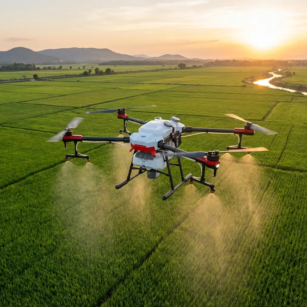
The Agras T50 is usually discussed as an agricultural workhorse. That framing is too narrow.
In harsh forest environments, especially where temperature swings distort visibility, stress vegetation, and compress the useful flight window, the T50 becomes something else: a stable heavy-lift platform for sensor-driven monitoring. Not a substitute for dedicated survey aircraft in every scenario, and not a magical one-size-fits-all system, but a serious field tool when the mission demands payload flexibility, weather tolerance, and repeatable low-altitude operations.
For teams working in forestry, watershed protection, perimeter vegetation management, or post-heat-event assessment, the real question is not whether the T50 can fly. It can. The better question is whether it can generate usable data when conditions are ugly and the target is subtle. That is where the conversation gets interesting.
Why extreme-temperature forest monitoring changes the equipment equation
Forests under heat stress do not fail all at once. Early warning signs emerge unevenly: canopy temperature anomalies, chlorophyll shifts, moisture-related reflectance changes, and localized nutrient imbalance in adjacent soils. In cold conditions, the challenge flips. Thermal contrast can become more useful, but batteries, airflow behavior, and sensor noise all become more consequential.
A conventional RGB workflow catches only the obvious. By the time discoloration is visible at scale, the management response is already late.
That is why third-party sensing matters on a platform like the T50. One of the most meaningful capability upgrades is not a bigger tank or a wider swath width. It is the addition of specialized imaging payloads that reveal conditions invisible to the naked eye.
A good example comes from outside forestry but translates well: a volunteer search team recently adopted a thermal imaging drone to locate missing dogs by detecting heat signatures. That detail matters here because it shows the operational value of thermal contrast in cluttered, difficult terrain. In forest monitoring, the same principle helps crews identify warm-bodied wildlife during pre-operation checks, detect residual heat after small fire events, and separate stressed vegetation zones from cooler surrounding canopy during early morning sorties. Thermal is not just for search. It is a practical layer of environmental intelligence.
The T50 as a platform, not just a sprayer
The strongest argument for the Agras T50 in forestry is platform stability under demanding field conditions. Operators already know the aircraft is designed for repetitive low-altitude work, liquid handling, and route consistency. Those traits transfer well to monitoring missions where terrain is uneven and operations must happen on tight schedules.
Its value grows when paired with RTK-supported flight discipline. In forest edge mapping, re-flying the same corridor with centimeter precision is not a marketing detail. It is how you distinguish a real canopy change from a flight-path mismatch. If your RTK fix rate is inconsistent, your comparison set degrades. A thermal hotspot that appears offset by a few meters from one mission to the next can trigger the wrong interpretation—especially in mixed stands with dense understory.
For consultants managing recurring assessments, repeatability beats drama. The T50’s practical strength is its ability to execute the same pattern over and over, holding line quality where forest roads, ridges, and variable microclimates make manual corrections expensive.
Where thermal imaging adds real forest value
The missing-dog example highlights a simple truth: heat signatures cut through visual confusion.
In forests, that matters in at least four civilian use cases:
1. Early stress spotting in tree stands
When daytime temperatures spike, stressed trees can present different thermal behavior than healthy surrounding canopy. This does not replace multispectral analysis, but it can guide where to look first.
2. Safer pre-treatment reconnaissance
If the T50 is being used later for targeted spraying in forestry or adjacent land management, a thermal pass can help identify unexpected animal presence in the intended work zone.
3. Post-heat-event inspection
After periods of extreme temperature, thermal surveys can reveal pockets of retained heat, irrigation irregularities near managed forest plots, or abnormal surface conditions along access routes.
4. Watercourse and wetland contrast checks
Temperature differences can help crews separate open water, saturated ground, and surrounding vegetation when visual imagery is flattened by glare or shadow.
This is exactly why a third-party thermal accessory can expand the T50’s usefulness far beyond broad-acre treatment work. If your team wants to discuss compatible sensor pathways and integration logic, a direct field conversation often saves time better than generic spec hunting: message our integration desk on WhatsApp.
Hyperspectral and multispectral: where the deeper analysis starts
Thermal tells you where to investigate. Spectral sensing helps explain why.
One reference point worth taking seriously comes from a hyperspectral application document centered on the Gaiasky mini system. It notes that hyperspectral reflectance data across 350–2,500 nm can capture subtle differences in soil physicochemical parameters. That wavelength span is operationally significant because it covers much more than visible color. It opens the door to detecting patterns tied to moisture, nutrient availability, and biochemical changes that can influence forest health at the stand level.
The same source also stresses that rapid, accurate, non-destructive assessment has become essential in precision agriculture. Forestry teams should read that as a warning and an opportunity. In remote or temperature-stressed forest zones, destructive sampling is slow, selective, and often too sparse. A sensor workflow that can narrow the sampling burden changes the economics of monitoring.
There is another nuance in that document that deserves more attention than it gets. It explains that derivative spectral processing can help isolate curve inflection points and extrema, but it can also amplify noise and reduce modeling accuracy. That is not an academic footnote. In extreme temperatures, where atmospheric shimmer, lighting variability, and platform vibration can all contaminate data quality, aggressive preprocessing may create false confidence. The document points to wavelet-based denoising as a more effective approach in some soil modeling cases, improving correlation while compressing data and simplifying models.
Translated into a forest monitoring workflow, that means this: if you mount a multispectral or hyperspectral payload on a T50-class platform, your results will depend as much on signal handling as on flight execution. Raw capture alone is not enough. Clean data pipelines matter.
What that means for forest and soil interaction zones
Forest health does not stop at the canopy. In many managed landscapes, especially plantation edges, reforestation blocks, and mixed agroforestry sites, soil chemistry drives the pattern seen in foliage.
The Gaiasky mini reference specifically identifies soil available potassium as a critical indicator of a soil’s ability to supply potassium to crops, while also noting that potassium imbalance can disrupt broader ecological material cycles. This matters in forestry because nutrient stress at the soil level may show up as uneven vigor, weaker drought tolerance, or poor establishment in newly planted areas.
At the same time, the same source is candid: practical hyperspectral estimation of available potassium remains less mature, and near-infrared prediction accuracy has been reported as relatively weak compared with other parameters. That honesty is useful. It tells us not to oversell the method.
So the right forestry interpretation is not “fly once and know your potassium status.” The better interpretation is: use spectral mapping to identify anomaly zones, then validate with targeted ground sampling. That hybrid method preserves the speed advantage of drone data without pretending every soil variable is equally solvable from the air.
This is where the T50 has a hidden advantage. Because it is already a field-capable utility aircraft, the same operational team can map a forest edge, identify stressed bands, validate a few points on the ground, and then return for precision application where permitted and appropriate. Monitoring and intervention stay inside one operational ecosystem.
Spray drift, nozzle calibration, and why monitoring missions still need application discipline
A technical review of the T50 would be incomplete without mentioning application mechanics, even in a monitoring-first article.
Why? Because many forest monitoring flights exist to support later action. If thermal or multispectral data flags a treatment zone, then spray drift, nozzle calibration, and swath width immediately become data-quality issues as well as treatment-quality issues.
A map may tell you a stressed corridor is 6 meters wider on the south slope than on the north slope. That only matters if the aircraft can translate that insight into controlled coverage. Nozzle calibration is what prevents overcompensating in the field. Spray drift management is what keeps a targeted intervention from crossing into waterways, young regeneration, or non-target habitat. Swath width should be treated as a variable to be validated under canopy-edge turbulence, not accepted as a static brochure figure.
Extreme temperatures intensify these concerns. Hot, dry air changes droplet behavior. Temperature inversions can produce deceptively calm conditions that are actually poor for predictable deposition. If your forest monitoring workflow feeds directly into an application plan, the T50’s operational discipline matters just as much as its sensing capacity.
Environmental durability and the case for IPX6K thinking
Forest work is rough on equipment. Dust from dry access roads, moisture at dawn, residue from previous operations, and repeated loading cycles all add stress.
That is where an IPX6K-level durability mindset becomes relevant, even if the mission profile is not traditional spraying. Forest monitoring often starts early, ends dirty, and rarely happens from a manicured launch site. A platform used in those conditions should be selected not only for payload capability but for washdown practicality, resistance to environmental exposure, and predictable maintenance routines between sorties.
Operators sometimes underestimate this when evaluating sensor add-ons. The accessory may be excellent in lab terms but weak in the field if cable routing, mounting integrity, or thermal management are not designed around real outdoor abuse. On a T50, the accessory is not just an extra. It becomes part of the aircraft’s operational reliability chain.
The motor-control lesson hidden in an unrelated technical document
One of the references provided is not about forestry or imaging at all. It is a BLHeli technical manual with ESC parameters such as startup power, damping force, commutation timing, and throttle change rate. At first glance, it seems irrelevant. It is not.
The document shows how small control parameters can materially affect response behavior. For instance, throttle change rate is listed across values from 2 up to 255, while commutation timing ranges from low to high. That is a reminder that aircraft performance is not only about major hardware specs. Fine control behavior shapes stability, responsiveness, and efficiency.
For T50 operators, the practical takeaway is broader than the specific ESC table. When carrying third-party thermal or spectral payloads in forest airspace, tuning assumptions matter. Sudden throttle transitions, aggressive route changes, or poorly matched mounting setups can inject vibration and degrade sensor output long before they create an obvious flight issue. Data quality often fails quietly.
This is one reason experienced operators tend to favor smooth route design over heroic stick inputs in constrained environments. In forest monitoring, the best flight is usually the least dramatic one.
A realistic role for the Agras T50 in forest intelligence work
The T50 is not the lightest mapping aircraft. It is not the cheapest way to capture a few photos over a woodland edge. It is also not limited to liquid application.
Its strongest role in extreme-temperature forest monitoring is as a multi-mission field platform:
- reliable repeated flights over hard terrain
- RTK-backed corridor consistency with centimeter precision
- compatibility with third-party thermal or spectral payload concepts
- direct workflow continuity from detection to targeted intervention
- practical survivability in dirty, wet, and heat-stressed operating environments
That combination matters more than any single spec headline.
If your mission is to understand forest conditions before they become visible failures, a platform that can integrate thermal heat-signature detection, support advanced multispectral or hyperspectral workflows, and return later for precision treatment has real operational value. The references behind this article point in that direction clearly. Thermal imaging has already proven its usefulness in difficult searches where visual methods fall short. Hyperspectral sensing across 350–2,500 nm has shown that subtle environmental differences can be measured, even if model design and noise control remain critical. Put those lessons together, and the T50 starts to look less like a single-purpose machine and more like a flexible node in a smarter forest operations system.
That is the version of the Agras T50 worth paying attention to.
Ready for your own Agras T50? Contact our team for expert consultation.