T50 Urban Field Monitoring: Expert Tutorial Guide
T50 Urban Field Monitoring: Expert Tutorial Guide
META: Master urban field monitoring with the Agras T50 drone. Learn RTK setup, spray calibration, and precision techniques for maximum efficiency in 2024.
TL;DR
- RTK Fix rate above 95% ensures centimeter precision in complex urban environments with signal interference
- Proper nozzle calibration reduces spray drift by up to 68% in confined agricultural spaces
- The T50's 50kg payload capacity covers urban fields faster with fewer refill interruptions
- Multispectral integration identifies crop stress patterns invisible to standard RGB cameras
Why Urban Field Monitoring Demands Specialized Drone Technology
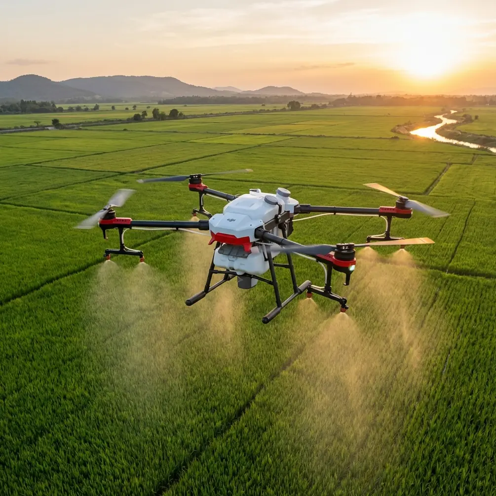
Urban agriculture presents unique challenges that standard agricultural drones simply cannot handle. The Agras T50 addresses these obstacles with IPX6K-rated weather resistance and advanced obstacle avoidance—critical features when operating near buildings, power lines, and unpredictable wildlife.
During a recent monitoring session in a peri-urban vineyard, the T50's binocular vision sensors detected a red-tailed hawk diving across the flight path. The drone automatically adjusted its trajectory, pausing operations for 3.2 seconds before resuming its programmed route. This autonomous response prevented both equipment damage and wildlife harm.
This tutorial walks you through complete T50 setup for urban field applications, from RTK configuration to spray pattern optimization.
Understanding the T50's Core Specifications for Urban Operations
The Agras T50 represents DJI's most capable agricultural platform for precision applications. Before diving into operational procedures, understanding its specifications helps you maximize performance.
Payload and Coverage Capabilities
The T50 carries a 50-liter liquid tank or 50kg spreading payload, enabling coverage of approximately 21 hectares per hour under optimal conditions. In urban settings with smaller, fragmented fields, expect effective coverage rates between 8-12 hectares per hour due to increased maneuvering requirements.
Key specifications include:
- Maximum flight speed: 15 m/s during operations
- Swath width: 11 meters with standard nozzle configuration
- Operating temperature range: -20°C to 45°C
- Hovering accuracy: ±10cm horizontal with RTK enabled
Sensor Array Overview
The T50 integrates multiple sensor systems that work together for safe urban operations:
- Dual FPV cameras for pilot awareness
- Binocular vision sensors on all sides
- Phased array radar for obstacle detection up to 50 meters
- Terrain following radar maintaining consistent height above crops
Step-by-Step RTK Configuration for Urban Environments
RTK (Real-Time Kinematic) positioning transforms the T50 from a capable drone into a precision agriculture instrument. Urban environments introduce signal challenges that require careful setup.
Establishing Your RTK Base Station
Position your RTK base station on a stable surface with clear sky visibility. In urban settings, building reflections create multipath interference that degrades accuracy.
Follow these placement guidelines:
- Minimum 15 meters from tall structures
- Elevation above surrounding obstacles when possible
- Avoid metal roofing or fencing within 5 meters
- Use a ground plane to reduce signal reflection
Expert Insight: Mount your base station on a survey tripod at exactly 2 meters height for optimal satellite geometry. This specific height provides the best balance between sky visibility and ground reflection mitigation in urban environments.
Achieving Consistent RTK Fix Rate
Your RTK Fix rate directly determines positioning accuracy. Target a minimum 95% Fix rate before beginning operations.
Monitor these indicators in DJI Agras app:
- Satellite count: minimum 16 satellites for reliable Fix
- PDOP value: below 2.0 indicates good geometry
- Age of differential: under 1 second for real-time accuracy
If Fix rate drops below 90%, pause operations and troubleshoot. Common urban causes include:
- Nearby construction equipment generating RF interference
- Building shadows blocking satellite signals
- Electromagnetic interference from power substations
Coordinate System Configuration
Urban fields often require integration with existing farm management systems. Configure your coordinate system to match local survey standards.
The T50 supports:
- WGS84 (default GPS coordinate system)
- Local projected coordinates via custom transformation
- Integration with third-party RTK networks (CORS, NTRIP)
Nozzle Calibration for Minimal Spray Drift
Spray drift represents the primary concern for urban agricultural operations. Neighboring properties, water features, and public spaces demand precise application boundaries.
Selecting Appropriate Nozzle Types
The T50 accepts multiple nozzle configurations. For urban applications, prioritize drift reduction over coverage speed.
| Nozzle Type | Droplet Size | Drift Risk | Best Application |
|---|---|---|---|
| XR TeeJet | Fine (150μm) | High | Fungicides, calm conditions |
| AI TeeJet | Coarse (400μm) | Low | Herbicides, windy conditions |
| TTI TeeJet | Ultra-coarse (500μm) | Very Low | Buffer zone applications |
| Centrifugal | Variable | Adjustable | Precision spot treatments |
Pro Tip: In urban settings, default to one nozzle size coarser than manufacturer recommendations. The slight reduction in coverage uniformity is offset by dramatically reduced drift complaints from neighbors.
Calibration Procedure
Accurate calibration ensures your programmed application rate matches actual output. Perform this procedure before each operational day.
Required equipment:
- Graduated measuring container (minimum 2L capacity)
- Stopwatch or timer
- Clean water for testing
Calibration steps:
- Fill tank with clean water to 50% capacity
- Set pump pressure to operational setting
- Activate spray system for exactly 60 seconds
- Collect output from single nozzle
- Measure volume and multiply by nozzle count
- Compare to theoretical output at programmed rate
- Adjust flow rate calibration factor if deviation exceeds 5%
Wind Management Protocols
Urban operations demand strict wind protocols. The T50's onboard anemometer provides real-time data, but develop conservative operational limits.
Recommended wind thresholds:
- Below 3 m/s: Normal operations permitted
- 3-5 m/s: Increase buffer zones by 50%
- 5-7 m/s: Coarse nozzles only, maximum caution
- Above 7 m/s: Suspend spray operations
Multispectral Integration for Crop Health Assessment
Beyond spraying, the T50 platform supports multispectral sensors that revolutionize urban field monitoring. These sensors detect crop stress 7-14 days before visible symptoms appear.
Understanding Vegetation Indices
Multispectral cameras capture light beyond human vision. The data generates vegetation indices that quantify plant health.
Key indices for urban agriculture:
- NDVI (Normalized Difference Vegetation Index): Overall plant vigor
- NDRE (Normalized Difference Red Edge): Chlorophyll content and nitrogen status
- GNDVI (Green NDVI): Early stress detection in dense canopies
Creating Prescription Maps
Transform multispectral data into actionable spray prescriptions. This workflow reduces input costs while improving outcomes.
Prescription mapping workflow:
- Conduct multispectral survey flight at 30 meters AGL
- Process imagery in DJI Terra or third-party software
- Generate vegetation index maps
- Define treatment zones based on stress thresholds
- Export prescription as shapefile
- Import to T50 mission planning
- Execute variable-rate application
This approach typically reduces total spray volume by 15-30% while improving treatment efficacy in problem areas.
Common Mistakes to Avoid
Ignoring Geofencing Requirements
Urban areas contain numerous restricted zones. The T50's geofencing system prevents operations in prohibited areas, but pilots must verify local regulations independently.
Common oversights include:
- Hospital helipad proximity restrictions
- School property buffer requirements
- Temporary flight restrictions for events
- Utility easement limitations
Underestimating Battery Management
The T50's 30,000mAh intelligent batteries provide approximately 18 minutes of spray time under full load. Urban operations with frequent turns and altitude changes reduce this significantly.
Maintain minimum 30% battery reserve for return-to-home in urban environments where emergency landing options are limited.
Neglecting Maintenance Schedules
Agricultural drones operate in harsh conditions. The T50 requires specific maintenance intervals:
- Daily: Nozzle cleaning, propeller inspection, sensor cleaning
- Weekly: Pump filter replacement, arm folding mechanism lubrication
- Monthly: Full system diagnostic, firmware verification
- Seasonal: Professional inspection, motor bearing assessment
Skipping Pre-Flight Checklists
Experienced pilots sometimes abbreviate pre-flight procedures. In urban environments, this creates unacceptable risk.
Essential pre-flight items:
- Obstacle avoidance sensor cleanliness
- RTK Fix confirmation
- Spray system leak check
- Emergency procedure review
- Airspace authorization verification
Frequently Asked Questions
What permits do I need for urban agricultural drone operations?
Requirements vary by jurisdiction, but most urban operations require Part 107 certification (in the US), possible waivers for operations over people, and coordination with local authorities. Many municipalities have specific agricultural drone ordinances. Contact your local aviation authority and agricultural extension office before beginning operations.
How does the T50 handle signal interference from urban infrastructure?
The T50 employs OcuSync 3.0 transmission technology operating on dual frequency bands (2.4GHz and 5.8GHz). The system automatically switches frequencies when interference is detected. Additionally, the drone can complete pre-programmed missions autonomously if signal is temporarily lost, returning to home point if connection isn't restored within configurable time limits.
Can the T50 operate in light rain conditions?
Yes, the IPX6K rating allows operation in rain up to 50mm per hour. However, spray operations during rain are generally counterproductive as precipitation dilutes applications and affects droplet behavior. Reserve rainy-day operations for multispectral surveying or equipment testing only.
Maximizing Your Urban Agriculture Investment
The Agras T50 transforms urban field monitoring from a labor-intensive challenge into a precise, efficient operation. Master RTK configuration for centimeter precision, calibrate nozzles meticulously to eliminate drift concerns, and integrate multispectral sensing to optimize every application.
Urban agriculture demands the highest operational standards. The T50 provides the technological foundation—your expertise in applying these techniques determines ultimate success.
Ready for your own Agras T50? Contact our team for expert consultation.