Agras T50 for Coastline Monitoring: Why Better Data Starts
Agras T50 for Coastline Monitoring: Why Better Data Starts With Better Light, Not Just Better Hardware
META: A field-focused look at using the DJI Agras T50 for coastline monitoring, with practical insight on light, RTK accuracy, spray-system tuning, and accessory-driven workflow gains.
Most discussions around the Agras T50 start with hardware. Payload. Flow rate. Coverage efficiency. Protection rating. Positioning. Those specs matter. On a wet, windy coastline, they matter a lot.
But they are not the true ceiling.
The real constraint in coastal monitoring is often perception: understanding what the environment is revealing at a specific moment, and configuring the aircraft to capture or act on that moment correctly. A recent photography essay made this point sharply in another context. Its argument was simple: stronger equipment alone does not guarantee stronger results. Higher resolution, more expensive optics, and broader dynamic range do not automatically produce better images. The difference between a flat record and an image with depth and meaning comes from recognizing light. That idea transfers surprisingly well to Agras T50 operations along coasts.
If you are using an Agras T50 to monitor shoreline vegetation, salt intrusion effects, marsh edges, drainage paths, or erosion-prone strips, the mission succeeds or fails on more than the aircraft’s capability sheet. The upper limit is determined by how well the operator reads light, wind, moisture, and surface reflectance, then matches those conditions to flight timing, sensor choices, nozzle calibration, and path design.
That is the real story.
The coastal problem is not just coverage
Coastal environments punish assumptions. The same section of shoreline can appear stable at noon and visibly stressed near low-angle sun. Wet sand can mask subtle elevation differences. Salt spray can alter visibility. Tidal sheen can create false visual continuity across mudflats and shallow water. Vegetation health can look acceptable in one pass and clearly uneven in another.
This is why a pure hardware mindset falls short.
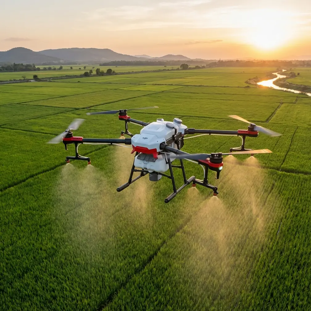
An Agras T50 brings serious field advantages for commercial coastal work. Its high-throughput design, broad swath potential, and ruggedized build make it useful not only for agricultural treatment missions but also for shoreline support tasks such as vegetation management, targeted application in buffer zones, and operational observation over difficult terrain. The mention of IPX6K-level protection is especially relevant here. In a coastal setting, exposure to blowing moisture, fine particulates, and frequent washdowns is not theoretical. A platform that tolerates harsh environmental contact reduces downtime and makes repeated missions more realistic over a full season.
Still, IPX6K alone will not tell you whether the discoloration along a reed line is salinity stress, tidal residue, or simply bad timing under harsh overhead light.
That interpretation comes from the operator.
What the photography lesson gets right for Agras T50 users
The photography source makes a useful distinction: one person records a scene, another creates an image with emotion, layering, and force, even when both are looking at the same landscape. The difference is not the machine. It is whether they understood the light in that moment.
For Agras T50 coastline monitoring, replace “emotion” with “usable insight.”
Two missions over the same coast can produce completely different operational value. One becomes a basic compliance record. The other reveals edge deterioration, drainage choke points, patchy vigor in salt-tolerant plantings, and localized treatment drift risk.
The deciding variable is often light angle and environmental timing.
Low-angle light early or late in the day can expose micro-relief on embankments and subtle breaks in surface texture that disappear under flat midday illumination. Reflective tidal surfaces can either ruin visual interpretation or, if anticipated correctly, help identify standing water boundaries and runoff channels. If you are working with a third-party multispectral accessory integrated into the workflow, the timing question becomes even more consequential. Spectral data is not magic; it still depends on disciplined acquisition conditions and good georeferencing.
This is where the T50 becomes more than a spraying aircraft. In capable hands, it becomes a decision platform.
RTK fix rate matters because coastlines punish positional ambiguity
A coastline is full of edges that move, blur, or appear to move. Waterlines shift. Marsh margins are soft. Vegetation bands are irregular. If your goal is repeatable monitoring rather than one-off observation, centimeter precision is not a luxury term. It is the difference between trend analysis and guesswork.
That is why RTK fix rate deserves more attention than it usually gets in general product discussions.
On a coastal mission, maintaining a strong RTK fix supports repeatable flight lines over the same transects and helps align temporal comparisons with much tighter confidence. If you are reviewing shoreline retreat, checking the consistency of a treatment corridor, or comparing pre- and post-storm conditions, positional drift creates false signals. A poor fix can make an edge look mobile when the mapping reference moved instead.
Operationally, this affects more than maps. It affects application quality too. When the T50 is assigned to targeted vegetation treatment in coastal buffer zones, centimeter-level consistency helps prevent overlap into sensitive adjacent strips and supports cleaner route repetition in later passes. In windy environments where spray drift is already a concern, positional stability reduces one more source of error.
The takeaway is straightforward: a strong RTK fix rate is not just a technical brag point. Along coastlines, it underpins whether your observations can be trusted from one mission to the next.
Spray drift is not a side note near the sea
The coastal reader looking into the Agras T50 may not be focused purely on monitoring in the abstract. Many real operations combine observation with intervention: treating invasive vegetation, managing buffer growth, supporting wetland restoration plots, or applying material to hard-to-access strips near embankments and channels.
That is where drift control becomes central.
Coastal wind behaves differently from inland wind. It can be more directional, more unstable near dunes or seawalls, and more deceptive due to thermal shifts and open fetch. A T50 operator who ignores nozzle calibration in this environment is effectively accepting variability before takeoff.
Nozzle calibration matters because it shapes droplet behavior, deposition consistency, and the practical width of a mission. The LSI terms you provided are not random SEO bait; they map directly to field reality. Swath width, for instance, is not a number to chase blindly. In a coastal setting, the widest possible swath may not be the most accurate or safest operational choice. A narrower effective swath under crosswind conditions can produce more dependable coverage and lower off-target movement.
The same logic applies to spray drift. If the goal is protecting fragile shoreline vegetation or working near water margins, calibration and environmental timing often matter more than raw throughput. This is another place where the “light over gear” lesson translates. Replace light with “conditions awareness.” Better hardware expands what is possible, but understanding the moment determines whether the result is clean or compromised.
A third-party accessory can expand what the T50 sees
One of the more interesting ways to push the Agras T50 beyond routine operation in coastal monitoring is by adding a third-party multispectral accessory to the workflow. Not every mission requires it. Some coastlines can be managed effectively with standard visual observation and precise operational logs. But when the job involves distinguishing plant stress patterns, salt intrusion signatures, or patchy establishment in restoration zones, multispectral interpretation can add another layer of confidence.
The key phrase here is “to the workflow.”
An accessory is not a shortcut to insight. It enhances capability when used with discipline. If visual passes are flown under poor light, if georeferencing is inconsistent, or if repeat missions are not aligned accurately, even sophisticated spectral data can become hard to trust. On the other hand, when paired with strong RTK performance, consistent mission design, and sensible timing, a multispectral add-on can help separate visual noise from real agronomic or ecological change.
That matters on coasts because surface appearance changes fast. Moisture, salt residue, and tide effects can mislead the eye. A well-integrated accessory can help the operator determine whether a discolored patch is transient surface effect or actual vegetation stress.
For teams evaluating accessory compatibility or integration options for the T50 in coastal projects, a practical starting point is to discuss field setup details directly before locking in a workflow.
Why “documentary” missions are not enough
The photography article makes another point worth borrowing. The same landscape can become either a mere record or something far more layered, depending on whether the creator truly understood what the scene was doing.
Many drone missions along coasts remain documentary in the weakest sense. They prove the aircraft flew. They collect images. They archive a route. But they do not necessarily produce decisions.
A stronger Agras T50 mission asks harder questions before launch:
- What exact coastal change are we trying to detect?
- At what tide state will that change be easiest to observe?
- Will low-angle light reveal relief better than diffuse cloud cover?
- Does this site need centimeter precision for repeat comparison?
- Is the intended swath width realistic under this wind profile?
- Do nozzle settings match the actual deposition objective?
- Is a multispectral accessory adding signal, or just complexity?
That shift in thinking is where professional value appears.
The T50 can absolutely handle demanding field routines. But the teams getting the most out of it are usually not the ones talking only about machine strength. They are the ones refining mission timing, surface interpretation, and environmental reading.
Building a better coastal workflow around the T50
For shoreline monitoring and adjacent treatment work, I would frame the Agras T50 workflow in four stages.
1. Read the site before you read the aircraft
Coasts are dynamic surfaces. Study wind channeling, reflective zones, access bottlenecks, and recurring water movement patterns first. This is the drone equivalent of a photographer watching how light falls before touching the shutter.
2. Lock down positional integrity
If the work has any comparison component, prioritize RTK fix reliability and repeatable route geometry. Centimeter precision is operationally significant because edge movement on coasts is often subtle before it becomes severe.
3. Tune application logic to actual conditions
When treatment is part of the job, spray drift and nozzle calibration should be treated as primary controls, not post-flight talking points. Adjust swath width to the environment, not to a brochure ideal.
4. Add sensing layers only when they answer a real question
A third-party multispectral tool can be valuable, especially where salt stress or vegetative inconsistency is hard to judge visually. But it should support a clear decision path, not create one more folder of unused imagery.
The real upper limit of Agras T50 coastline work
This brings us back to the central lesson from that photography piece.
The source argued that the upper limit of a landscape image is often set by the photographer’s understanding of the light, not by the camera body or lens. That same principle applies to the Agras T50 in coastal operations. Better hardware helps. More capability helps. Rugged protection, wider coverage potential, RTK support, and accessory options all help.
But the upper limit is still human.
It is the operator who decides whether low morning light will expose berm irregularities better than a midday pass. It is the operator who recognizes when wind makes the nominal swath width unrealistic. It is the operator who knows that nozzle calibration is not a maintenance checkbox but a drift-control strategy. It is the operator who understands that a strong RTK fix rate is what makes next month’s shoreline comparison meaningful rather than approximate. And it is the operator who can tell when a multispectral accessory adds clarity instead of confusion.
That is why the best Agras T50 coastline programs do not obsess over equipment in isolation. They build systems around interpretation.
The drone does the work in the air. The real expertise happens before takeoff and after landing.
Ready for your own Agras T50? Contact our team for expert consultation.