Agras T50 Field Report: Mapping Wildlife in Extreme
Agras T50 Field Report: Mapping Wildlife in Extreme Temperatures Without Losing Precision
META: Practical Agras T50 field report for wildlife mapping in extreme heat and cold, covering RTK fix stability, antenna positioning, IPX6K durability, swath control, and nozzle calibration considerations.
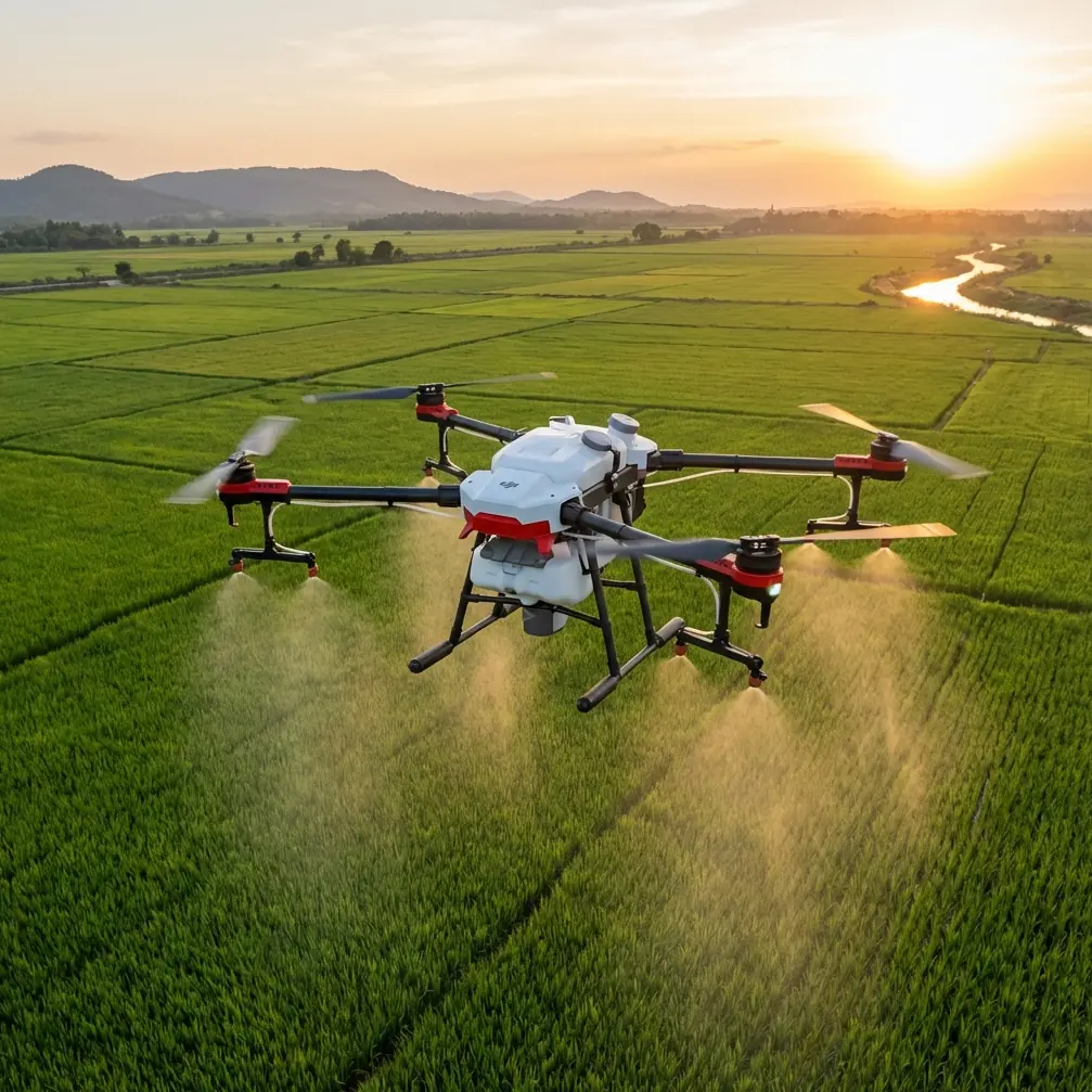
Wildlife mapping with an Agras T50 is not the obvious assignment. Most crews know the aircraft as a serious agricultural workhorse built for spraying and spreading, not as a first-pick platform for habitat surveys. Yet in extreme environments, that background becomes an advantage. The T50 is designed to keep working around dust, moisture, chemical exposure, and long field days. Those traits matter when the mission is not crop treatment, but counting animal movement corridors, identifying habitat edges, and recording repeatable observations in places where temperature swings can punish both aircraft and crew.
I have been asked more than once whether the Agras T50 makes sense for wildlife mapping when the weather is brutal. My answer is yes, with conditions. You need to understand what this platform does well, what it was built for, and how to adapt its strengths to data collection instead of field application. The details that matter most are not glamorous. They are the details that decide whether your flight lines stay clean, whether your RTK remains stable, and whether your aircraft comes home with usable data instead of gaps.
This field report is built around one scenario: using an Agras T50 in extreme heat and cold to map wildlife activity and habitat conditions with repeatable accuracy.
Why the Agras T50 belongs in this conversation
The T50 sits in a category of UAVs that are expected to operate in punishing agricultural conditions. That alone gives it unusual relevance for wildlife work in marginal climates. Wet grass at dawn, fine dust in dry scrub, residue buildup around working parts, repeated transport in trucks, fast redeployment between sites—those are normal realities in agricultural aviation, and they overlap surprisingly well with field ecology.
One detail worth emphasizing is its IPX6K protection level. That matters operationally, not as a brochure badge. In wildlife mapping, a platform often launches near muddy tracks, wet reeds, irrigation channels, and dusty trailheads. Hardware exposed to hard washdown conditions and rough field contamination has a better chance of staying reliable across consecutive survey days. If you are moving from a cold dawn launch into a warmer afternoon and dealing with condensation risk on the ground, robust environmental protection is not a luxury. It directly affects turnaround time and maintenance burden.
The second detail is centimeter precision through RTK positioning, assuming you can maintain a strong fix. That changes the quality of wildlife mapping in practical ways. If your task is repeated monitoring—nesting boundaries, grazing pressure, wetland edge movement, game trail density, or thermal refuge locations—precision matters less for a pretty map and more for temporal comparison. Returning to nearly the same path week after week means the changes you detect are more likely to be ecological and less likely to be artifacts of drift or sloppy georeferencing.
Extreme temperatures change the whole workflow
Most pilots focus on the aircraft first. In reality, extreme temperature missions are workflow problems.
In high heat, you are fighting battery stress, haze, thermal shimmer over bare ground, and the temptation to fly longer than conditions support. In cold weather, you are dealing with slower setup, stiffer components, reduced battery efficiency, and longer waits before sensors and GNSS performance settle into something dependable. The Agras T50 can tolerate harsh field environments, but that does not mean every launch window is equal.
For wildlife mapping, the best data often comes near temperature extremes: early morning in summer, when animals are active before heat buildup, or cold-season windows when tracks, congregation points, and habitat contrast become easier to detect. That is also when hardware can behave unpredictably if rushed.
My rule with the T50 is simple: in extreme temperatures, never judge readiness by power-on alone. Judge it by stability. Stable attitude. Stable GNSS. Stable communications. Stable live view if your payload configuration supports the mission.
RTK fix rate is the real gatekeeper
You can have enough satellites and still get poor mapping consistency. What you need is a dependable RTK fix rate, not a temporary lock that drops as soon as you turn into a marginal section of terrain.
For wildlife mapping, especially where survey overlap matters, RTK instability creates a chain reaction. Flight lines stop matching the plan. Repeated passes vary in offset. Habitat boundaries look like they moved when the aircraft actually did. If the goal is to compare seasonal movement against earlier data, weak fix integrity can quietly ruin the survey.
This is where antenna setup deserves more attention than most crews give it.
Antenna positioning advice for maximum range
If you want the best communication margin and more reliable correction continuity, treat antenna position as part of the flight plan.
- Place the base or relay antenna on the highest clear point available, not merely the closest convenient spot.
- Keep it away from vehicle roofs, chain-link fencing, power systems, and metal storage cases that can distort signal behavior.
- Maintain clean line of sight in the direction of the survey block. Trees and terrain shoulders do more damage to real-world range than pilots often admit.
- If you are operating in broken terrain, orient your setup so the aircraft spends most of the mission in front of the antenna rather than crossing behind obstructions.
- In extreme heat, avoid placing the station directly over radiating surfaces like dark truck hoods or rock slabs that can add local thermal distortion and make setup work unnecessarily inconsistent.
That sounds basic, but it has direct mapping consequences. Better antenna placement improves link confidence, which supports a steadier RTK fix rate, which in turn protects centimeter precision over repeated missions. If your team wants a second opinion on layout before a field day, I sometimes point operators to this quick WhatsApp line for setup questions: message the field desk here.
Swath width matters even when you are not spraying
This is where operators coming from agriculture have an edge. They already think in swaths.
With the Agras T50, swath width is usually discussed in application terms: how much area is covered efficiently while maintaining treatment quality. For wildlife mapping, the same concept still matters, but the objective changes. You are now balancing coverage, overlap, terrain variability, and the level of habitat detail you need to identify.
A wide swath sounds efficient until uneven vegetation, slope changes, and subject movement start creating blind zones. In extreme temperature conditions, those problems become more visible. Hot air rising off the ground can degrade image consistency, while cold low-angle light can deepen shadows and hide surface detail. Narrowing the effective mapping swath often produces better repeatability than pushing for maximum area per sortie.
That is the operational significance: swath width is not just an efficiency setting. It determines whether your map is useful for ecological interpretation or merely broad coverage with weak analytical value.
For wildlife teams tracking movement corridors, I generally prefer more overlap and more conservative lane spacing than a farm operator would use for straightforward treatment work. The T50’s platform stability and guidance precision help make that discipline practical.
Nozzle calibration still matters on a mapping mission
At first glance, nozzle calibration sounds irrelevant if your mission is wildlife mapping. It is not.
Even when the T50 is being used primarily as a survey platform in mixed agricultural-wildland settings, crews often shift between observation tasks and treatment-adjacent work. If the aircraft is part of a broader habitat management program—say invasive plant suppression near a wetland edge or vegetation management around wildlife corridors—poor nozzle calibration can distort the ecological picture.
Why? Because application inconsistency affects what you later observe from the air. Uneven output changes vegetation stress patterns, treatment boundaries, and regrowth appearance. That can lead a mapping crew to misread habitat response or overestimate the effects of weather and animal use.
The same goes for spray drift. In hot, dry conditions, drift becomes more than an application quality problem. It becomes a data contamination problem. If treatment spreads beyond intended boundaries, the resulting vegetation signature may be misclassified in a follow-up survey. Anyone using the T50 across both management and mapping functions needs discipline here. Calibrate nozzles correctly, understand droplet behavior under local weather, and document treatment blocks so the mapping data remains interpretable.
This is one of those cross-functional realities that separates solid field operations from expensive confusion.
What about multispectral work?
The phrase multispectral gets thrown around too loosely. On wildlife projects, operators often assume any advanced aerial mission should include it. Sometimes yes, sometimes no.
If your goal is to map forage health, water stress in habitat zones, post-disturbance recovery, or subtle vegetation differences tied to species movement, multispectral data can be highly useful. But it only helps when the rest of the workflow is disciplined enough to support repeatable collection. If your RTK fix rate is unstable, your flight timing is inconsistent, or your overlap is weak because you pushed swath width too far, multispectral layers will not rescue the mission.
In extreme temperatures, this becomes even more critical. Heat can alter scene quality and reduce consistency between passes. Cold can slow setup and tempt crews to abbreviate calibration steps. The T50 gives you a durable, field-ready platform, but the value of any advanced data product still depends on boring fundamentals done properly.
Where the T50 earns trust in harsh environments
What I appreciate about the Agras T50 in this role is not that it pretends to be a specialist wildlife drone. It does not. It earns trust because it is engineered for demanding outdoor operations and can be adapted intelligently.
The IPX6K durability profile means the aircraft is less precious in ugly field conditions. That lowers operational friction. Teams are more willing to deploy early, work near moisture, and clean the aircraft properly after dirty missions. Reliability improves because the machine is treated as a tool, not a fragile display piece.
The RTK-driven centimeter precision means repeated mapping can support actual comparison over time, not just rough visual storytelling. For wildlife managers, that is the difference between “we think use increased near the water source” and “the movement corridor shifted measurably over the last survey cycle.”
And the platform’s agricultural DNA brings useful habits with it: thinking about swath management, environmental conditions, calibration, and field efficiency. Those habits translate well to wildlife mapping in difficult temperatures.
A practical field routine I recommend
If I were sending a team out tomorrow with a T50 for wildlife mapping in extreme heat or cold, I would insist on this sequence:
- Set the antenna position first, with line of sight and terrain in mind.
- Wait for a trustworthy RTK fix rather than launching on impatience.
- Use conservative swath planning with stronger overlap than you think you need.
- Log ambient conditions at launch and landing, especially temperature and wind behavior.
- If the aircraft is also used for vegetation treatment, verify nozzle calibration records and mark all treatment zones before interpreting habitat imagery.
- Clean and inspect the aircraft after each mission, especially after dusty hot-weather surveys or wet cold-weather operations.
That routine sounds ordinary because it is. Good mapping with the Agras T50 in extreme temperatures is won by ordinary discipline, repeated every flight.
Final field judgment
The Agras T50 is not the obvious hero of wildlife mapping, and that is exactly why it deserves a closer look. In extreme conditions, obvious choices often disappoint because they are optimized for ideal survey days rather than rough real-world deployment. The T50 brings durability, field tolerance, and precision that can serve wildlife monitoring well when the operator respects the limits of weather, signal geometry, and data integrity.
If your mission depends on repeatable observations across heat, cold, dust, and wet ground, this aircraft has a legitimate place in the conversation. Just do not fly it like a generic mapping drone. Fly it like a hardened field platform whose strengths only show up when the crew understands why RTK fix rate, antenna placement, swath width, spray drift, and nozzle calibration all shape the final map, even on a wildlife job.
Ready for your own Agras T50? Contact our team for expert consultation.