Agras T50 in Remote Vineyard Work: What a Model Expo
Agras T50 in Remote Vineyard Work: What a Model Expo and Flight Training Notes Reveal About Better Mapping Discipline
META: A field-driven case study on using Agras T50 in remote vineyard operations, with practical insight on wind, altitude discipline, pacing, safety checks, RTK precision, and workflow control.
Remote vineyard work punishes assumptions.
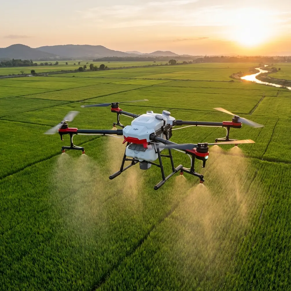
Rows look simple from the road. They are not. Terrain folds unexpectedly, wind behaves differently above the canopy than it does at takeoff, and battery decisions that seem minor beside the truck become operationally expensive halfway through a mission. When people talk about the Agras T50, they often focus on capacity, spraying throughput, or the broad promise of smarter agriculture. That misses the real story in difficult sites. In remote vineyards, the value of the platform is not just power. It is how well the entire operation can be disciplined around precision, timing, and environmental awareness.
That sounds abstract until you connect it to two unlikely reference points: a recent public appearance by T-HOBBY at the 2026 Beijing Model Expo, and a pair of training documents that have nothing to do with vineyard marketing and everything to do with how skilled operators actually think. One is a DJI TT education drone guide warning that wind conditions can change sharply once the aircraft climbs above 10 meters. The other is an aerobatic training text emphasizing a deceptively simple habit: pause briefly between actions so you create time to observe, correct, and keep the maneuver clean.
Those details matter more to Agras T50 fieldwork than they first appear.
Why remote vineyards expose weak operating habits
A remote vineyard is rarely a flat, forgiving rectangle. It may sit on terraced land, broken slopes, or ridgelines where airflow accelerates and curls around blocks. Even when the launch point feels calm, the air above the vines may not cooperate. The educational TT material makes this point in plain terms: near the ground, conditions can feel almost windless, but above 10 meters there may already be strong wind. For a micro training drone, the guidance is to stay low, ideally below 10 meters in real flying.
The Agras T50 is not a TT. It is built for real agricultural work, not classroom programming. Still, the operational lesson transfers directly: surface impressions are unreliable. In vineyard mapping and application planning, altitude is not just a mission parameter. It is a risk multiplier. A few extra meters can alter spray drift exposure, change image consistency, and reduce confidence in edge accuracy along narrow vine corridors.
For remote blocks, that becomes especially relevant when trying to maintain consistent swath width across uneven topography. If the aircraft is flying a route that climbs relative to the takeoff point, the pilot may think the profile is routine while the aircraft is already in a different wind layer. That is where RTK Fix rate and centimeter precision start to matter in practical, not brochure, terms. Precision navigation is only valuable if the rest of the operation respects the atmosphere the aircraft is moving through.
A case study mindset, not a spec-sheet mindset
Last season, on a remote vineyard property with long rows laid across variable elevation, the biggest challenge was not route generation. It was maintaining consistency from block to block while avoiding drift-prone periods in the afternoon. The T50 was used as part of a broader digital workflow to assess row alignment, canopy variability, and treatment planning. In that environment, even if multispectral data from separate platforms or sensors informs agronomic decisions, the T50’s job still depends on being flown with a surveyor’s discipline rather than a show pilot’s confidence.
That is where the second reference becomes unexpectedly useful.
The aerobatic training text describes building a symmetrical 45-degree climb, then deliberately adding a slight pause before the next control input. The point is not style. The point is creating enough time to check attitude, confirm alignment, and avoid compounding errors. It even warns that trying to blend all corrections continuously can turn a clean maneuver into a mess.
Translate that into vineyard operations and the lesson is obvious: do not rush transitions.
Before takeoff, pause after your physical inspection. Before starting a new block, pause after loading the route and verify terrain assumptions. After battery replacement, pause long enough to confirm that the next sortie is not inheriting the wrong altitude reference, tank state assumption, or row orientation. Skilled field teams often look fast, but what they really are is deliberate. Their timing includes built-in observation windows.
With the Agras T50, that rhythm matters because the aircraft encourages productivity. High-output machines tempt crews to compress steps. In remote vineyards, that is exactly how drift, overlap inconsistency, and mapping gaps begin.
The wind lesson that operators ignore at their own expense
The TT training document gives another practical constraint: a recommended operating temperature range of 0 to 40 degrees Celsius, with preference for good lighting, open ground, and safe surroundings. Again, that is written for a small education drone, but the logic is deeply relevant to any field UAV workflow. Light quality affects visual awareness. Open launch and recovery areas reduce avoidable incidents. Environmental margins should be chosen, not hoped for.
In vineyards, the wind issue deserves special treatment because it affects two different layers of work at once.
First, mapping quality. If you are using the T50 in a planning or assessment role over remote rows, crosswind can create inconsistent track behavior, particularly where terrain forces subtle height changes. That can reduce confidence in repeatability from one pass to the next, especially when trying to compare blocks over time.
Second, application integrity. Spray drift is not just a compliance phrase. In vineyards, where adjacent rows, roads, neighboring plots, and sensitive canopy zones can all sit close together, drift is a biological and economic problem. Nozzle calibration only matters if atmospheric conditions still support the intended deposition pattern. If the pilot is lulled by calm air at ground level but the aircraft is working in a faster layer above the canopy, the operation may stay technically airborne while becoming agronomically sloppy.
The reference note about stronger wind above 10 meters is useful precisely because it is so simple. It reminds us to distrust the launch-point illusion.
The battery management tip that saves remote missions
Here is the field tip I wish more crews treated as non-negotiable: never judge battery readiness only by charge percentage when working remote vineyard blocks. Judge it by what the next segment of terrain will demand.
A battery at high state of charge can still be the wrong battery for the next job if the upcoming block includes elevation gain, a longer transit from the staging point, or a return leg likely to face a headwind. In remote sites, crews often plan by row count. Better teams plan by energy profile.
My own rule with the Agras T50 workflow is simple. After every battery swap, I write down not just pack order but the mission character of the next sortie: downhill, uphill, cross-slope, or far-edge transit. That takes seconds and changes decision quality dramatically. If the next route pushes to the back side of a remote vineyard and the wind is beginning to rise aloft, I do not send the pack that has already had the hardest thermal history of the day. I save the best-performing battery for the worst energy geometry.
That is the same “slight pause” discipline from the aerobatic document, just applied to logistics instead of stick inputs.
What T-HOBBY’s 2026 Beijing Model Expo appearance really signals
At first glance, T-HOBBY’s recent appearance at the 2026 Beijing Model Expo seems unrelated to agricultural UAV practice. The event summary says the exhibition concluded successfully and that T-HOBBY delivered a standout display. Fair enough. But for professionals watching the UAV space, public technical showcases still matter.
They indicate where operator culture is heading.
A strong showing at a model expo is not proof of vineyard competence, but it does point to a healthy ecosystem around aircraft literacy, training visibility, and user engagement. The gap between hobby-grade flying and agricultural mission discipline remains large, yet the best commercial operators often emerge from communities that value handling skill, equipment care, and flight awareness. Those habits are transferable when properly retrained for civilian agricultural work.
That is why I do not dismiss expo culture outright. If anything, it reminds us that aircraft confidence must be redirected into procedure. The Agras T50 is most effective when treated less like a machine that can simply overpower field complexity and more like one that rewards mature workflow design.
Mapping vineyards with Agras T50 means respecting the site, not just the system
When readers search for “Expert Mapping with Agras T50,” they often expect a discussion centered on speed, coverage, and onboard intelligence. Those have their place. But remote vineyard performance is usually won or lost on subtler points:
- whether the crew noticed the wind layer change above canopy height
- whether nozzle calibration was checked against the actual block conditions rather than the morning plan
- whether RTK stability was confirmed before committing to narrow row geometry
- whether swath width assumptions were adapted to slope and airflow
- whether the team built pauses into the operation for visual verification and route correction
This is also where ruggedness matters. A machine expected to work around moisture, dust, and repeated field handling benefits from robust environmental protection, and features such as IPX6K-level resistance become operationally meaningful in agriculture because vineyard work is messy by nature. Dust on access roads, residue around staging areas, and intermittent moisture are part of the day, not exceptions.
Still, environmental sealing is not a substitute for judgment. It simply gives the operator more margin when the site is less than perfect.
A practical workflow for remote vineyard crews
If I were briefing a team preparing to use the Agras T50 in a remote vineyard mapping and treatment-planning context, I would keep the workflow blunt:
Start low and verify. If near-ground air feels calm, do not assume the same conditions above the canopy. Make a deliberate early assessment of wind behavior at working height.
Use terrain-aware route logic. A block that looks uniform on a tablet may produce very different aircraft behavior from one end to the other. Altitude consistency is an agronomic issue, not just a pilot issue.
Build pause points into the mission. The aerobatic training phrase “slightly pause” belongs in agricultural operations. Pause after route load. Pause after battery swap. Pause before entering a new block. That is where corrections happen cleanly.
Treat battery assignment as a terrain decision. Save your strongest pack for the segment with the worst return geometry or most likely headwind.
Respect the precision stack. Centimeter precision and RTK Fix rate only deliver value if launch setup, environmental awareness, and operator timing are equally disciplined.
If you need a practical discussion about configuring that kind of field workflow, this direct Agras operations chat is the most natural place to start.
The deeper lesson
The most useful ideas in UAV operations are often the least glamorous. A warning about wind above 10 meters. A recommendation to choose open, safe flying areas. A teaching habit built around inserting a short pause between actions. A successful expo appearance that reflects confidence and craft in public view.
None of those facts alone tells you how to run an Agras T50 in a remote vineyard. Together, they point to the operating philosophy that separates clean results from expensive noise.
Remote vineyard work rewards restraint. The best crews do not chase speed first. They create time to observe. They verify the environment at the height that matters, not the height that feels comfortable. They calibrate for the crop, the slope, and the air on that specific day. And they never confuse machine capability with mission certainty.
That is how the Agras T50 becomes more than a powerful agricultural platform. It becomes a reliable instrument inside a disciplined field system.
Ready for your own Agras T50? Contact our team for expert consultation.