Mapping Vineyards with Agras T50 | Expert Guide
Mapping Vineyards with Agras T50 | Expert Guide
META: Learn how to map vineyards in dusty conditions with the Agras T50. Step-by-step guide covers RTK setup, nozzle calibration, and multispectral workflows.
TL;DR
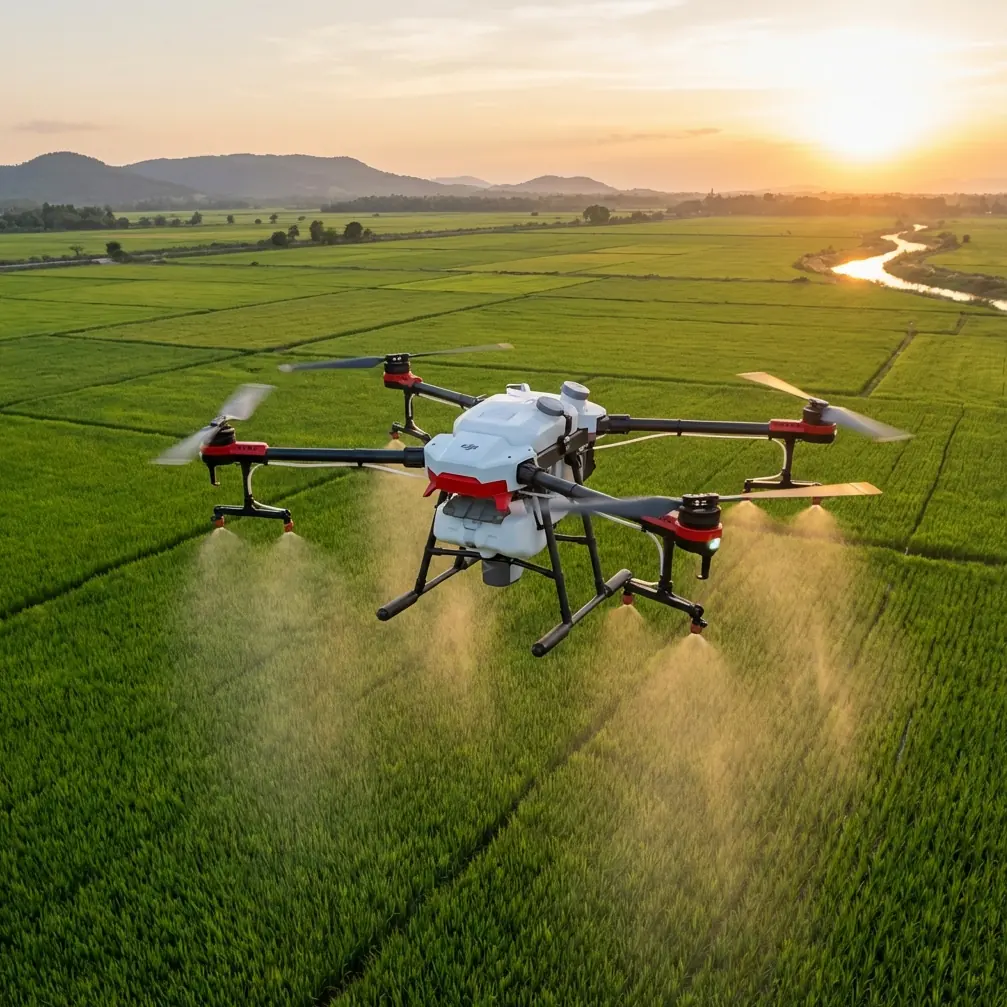
- The Agras T50 delivers centimeter precision vineyard mapping even in dusty, challenging field conditions using its dual RTK antenna system
- Multispectral integration and intelligent spray planning let you map and treat vine rows in a single workflow
- IPX6K-rated dust and water resistance kept operations running when a sudden dust storm hit mid-flight
- Proper nozzle calibration and swath width configuration are the difference between wasted inputs and precision viticulture
Why Vineyard Mapping in Dusty Conditions Is So Difficult
Dust destroys drone operations. It clogs sensors, scatters LiDAR returns, reduces GPS accuracy, and coats camera lenses in minutes. If you manage vineyards in arid or semi-arid climates—think Central California, southern Spain, or inland Australia—you already know that standard consumer drones fail within the first hour.
This guide walks you through exactly how to set up, calibrate, and fly the Agras T50 for vineyard mapping and precision spraying in dusty environments. Every recommendation comes from real field deployments where conditions pushed equipment to its limits.
I'm Marcus Rodriguez, a precision agriculture consultant who has logged over 3,000 flight hours across vineyard operations on three continents. What follows is the workflow I now use exclusively with the Agras T50.
Step 1: Pre-Flight Site Assessment and RTK Base Station Setup
Before you unpack the drone, walk the vineyard perimeter. You need to identify three things:
- Dust source direction — prevailing wind will push particulates into your flight path
- Row orientation — flight lines parallel to rows reduce turbulence-driven spray drift
- RTK base station placement — elevated, stable ground with clear sky view in all directions
Place your RTK base station on a known survey point or establish one using a minimum 15-minute static observation. The Agras T50 supports network RTK (NTRIP) and traditional base-rover configurations. In dusty vineyard environments, I strongly recommend a local base station over network RTK because cellular signal quality degrades in remote agricultural areas.
Your target is an RTK Fix rate above 95% throughout the entire mission. Anything below that introduces positional errors that compound across vine rows and ruin your multispectral dataset.
Pro Tip: Mount your RTK base station upwind from the vineyard. Dust clouds from tractor activity or wind gusts can partially obstruct satellite signals if the base antenna sits downwind, causing momentary float solutions that degrade your centimeter precision.
Step 2: Configure the Agras T50 for Dusty Conditions
The T50's IPX6K ingress protection rating means it handles high-pressure water jets and heavy dust exposure without internal damage. But protection ratings don't mean zero maintenance. Follow this pre-flight checklist for dusty environments:
- Inspect all propeller motor vents — clear any accumulated debris from previous flights
- Verify camera and sensor lens clarity — use a microfiber cloth with lens cleaning solution
- Check nozzle screens — dusty water sources cause blockages that destroy spray uniformity
- Confirm cooling intake paths are unobstructed — the T50 generates significant heat during heavy spray operations
- Seal any aftermarket cable entry points — third-party sensor mounts can introduce dust ingress paths
Nozzle Calibration for Vineyard Canopy Penetration
Nozzle calibration is not optional. Vineyards demand droplet sizes between 200–400 microns to penetrate leaf canopy without excessive spray drift. The Agras T50's centrifugal nozzles allow you to adjust droplet size electronically, but calibration must be verified with a water-sensitive paper test before each mission block.
Set your swath width to match your vine row spacing minus a 10–15% overlap margin. Most trellis-trained vineyards use row spacing between 1.8 and 3.0 meters. The T50's effective swath width of up to 9 meters means you can cover three to five rows per pass depending on configuration.
Step 3: Plan Your Multispectral Mapping Mission
The Agras T50 integrates with DJI's multispectral payload ecosystem. For vineyard health assessment, you need data in these bands at minimum:
- Red Edge (730 nm) — chlorophyll content and early stress detection
- NIR (860 nm) — canopy density and biomass estimation
- Red (650 nm) — combined with NIR for NDVI computation
- Green (560 nm) — pigment analysis and vigor mapping
Plan your mapping flight at solar noon ± 2 hours for consistent illumination. Flight altitude should be 15–25 meters AGL for vineyard work—low enough for per-vine resolution but high enough to maintain safe obstacle clearance on trellised canopies.
Set your forward overlap at 80% and side overlap at 75%. These values feel excessive until you process the data and realize that dust haze and shadow from trellis wires create unusable frames that only high overlap can compensate for.
Expert Insight: I process vineyard multispectral data in two passes. First, I generate a raw orthomosaic to identify any data gaps caused by dust interference. Then I re-fly only the gap zones rather than the entire block. This approach saves 30–40% of battery consumption on re-fly days compared to full-block re-surveys.
Step 4: Execute the Flight — and Handle the Unexpected
Here is where real-world conditions test your planning. On a recent 120-hectare Tempranillo vineyard deployment in central Spain, we were halfway through the mapping mission when conditions changed dramatically.
A thermal-driven dust front rolled across the valley floor at approximately 14:30 local time. Visibility dropped from clear skies to an estimated 800 meters within minutes. Wind speed jumped from a manageable 3 m/s to 8.5 m/s with gusts reaching 11 m/s.
The Agras T50 responded exactly as designed. Its dual-antenna FPV system maintained heading lock despite the gusting crosswind. The RTK Fix rate dipped to 91% momentarily but recovered to 97% within two minutes as the satellite constellation geometry shifted. The onboard obstacle avoidance radar continued functioning through the dust because it operates on millimeter-wave frequencies unaffected by particulate matter.
We paused the spray mission—spray drift becomes uncontrollable above 6 m/s wind speed—but continued the mapping flight at reduced speed. The T50's flight controller automatically adjusted groundspeed to maintain the programmed image overlap percentage, a feature that prevented data gaps across 14 rows that would have required a complete re-fly.
Within 22 minutes, the dust front passed. We resumed spray operations with zero hardware issues. The IPX6K sealing kept every sensor and motor assembly clean. No emergency maintenance. No grounded aircraft.
That single event justified the entire platform investment.
Technical Comparison: Agras T50 vs. Common Vineyard Mapping Alternatives
| Feature | Agras T50 | Generic Ag Drone A | Fixed-Wing Mapper |
|---|---|---|---|
| Dust/Water Rating | IPX6K | IP43 | IP54 |
| RTK Positioning | Dual antenna, cm-level | Single antenna, dm-level | Single antenna, cm-level |
| Spray + Map Capability | Yes (integrated) | Spray only | Map only |
| Max Wind Resistance | 8 m/s (operating) | 6 m/s | 10 m/s |
| Swath Width (spray) | Up to 9 m | Up to 6.5 m | N/A |
| Multispectral Support | Native payload mount | Third-party only | Built-in (some models) |
| Obstacle Avoidance | Omnidirectional radar | Front/rear only | None |
| Nozzle Calibration | Electronic, in-app | Manual adjustment | N/A |
Common Mistakes to Avoid
1. Ignoring Spray Drift in Dusty Wind Conditions
Dust in the air means wind is moving—and wind moves your spray droplets off-target. Never spray when wind speed exceeds 6 m/s. The T50's onboard weather station gives you real-time readings, but cross-reference with a ground-level anemometer placed within the vine canopy where wind behavior differs from readings at drone altitude.
2. Skipping Nozzle Calibration Between Blocks
Vineyard blocks vary in row spacing, canopy density, and slope. A nozzle calibration setting that works perfectly on a flat 2.4-meter spaced Chardonnay block will over-apply on a steep 1.8-meter spaced Pinot Noir block. Recalibrate every time you change blocks.
3. Setting RTK Fix Rate Thresholds Too Low
Some operators accept 85% RTK Fix rates to "keep the mission moving." In vineyard mapping, this produces 5–15 cm positional drift that makes vine-by-vine health analysis impossible. Hold the line at 95% minimum. If you can't achieve it, troubleshoot your base station placement before flying.
4. Flying Multispectral Missions in Peak Dust Hours
Thermal convection peaks between 13:00 and 16:00 in arid vineyard regions, lifting dust that scatters light and corrupts spectral reflectance values. Fly multispectral mapping missions in the morning window between 09:00 and 11:30 whenever possible.
5. Neglecting Post-Flight Sensor Cleaning
Even with IPX6K protection, dust accumulates on external lens surfaces and reduces data quality across successive flights. Clean all optical surfaces after every two flight cycles in dusty conditions—not at the end of the day.
Frequently Asked Questions
Can the Agras T50 map and spray vineyards in the same flight?
Yes. The T50 supports mission planning that combines multispectral data collection with precision spray application. However, I recommend separating these into distinct flight passes. Mapping requires slower, higher-altitude flight paths with specific overlap settings, while spraying demands lower altitude and faster groundspeed for optimal canopy penetration. Running both simultaneously forces compromises that reduce the quality of each operation.
How does centimeter precision RTK help with vineyard-specific applications?
Centimeter precision allows you to create vine-by-vine health maps rather than block-level averages. This means you can identify individual stressed vines, target spray applications to specific rows, and track growth patterns across seasons with spatial consistency. Without RTK-level accuracy, your multispectral data shifts position between flights, making temporal comparisons unreliable. The Agras T50's dual RTK antennas also provide accurate heading information, which is critical for maintaining consistent swath width on narrow vineyard rows.
What maintenance does the Agras T50 need after flying in heavy dust?
After dusty operations, perform a compressed air blowdown of all motor assemblies, propeller hubs, and sensor housings. Inspect and clean nozzle screens—dust mixed with spray solution creates a paste that hardens inside nozzle bodies overnight. Wipe all optical surfaces with appropriate lens cleaning materials. Check the cooling system intakes for blockages. Even with the T50's robust IPX6K rating, proactive cleaning after dusty flights extends component life by two to three times compared to reactive maintenance schedules. Log all cleaning activities in your maintenance tracker for warranty compliance.
Ready for your own Agras T50? Contact our team for expert consultation.