Expert Mapping with Agras T50 for Remote Power Line Corridor
Expert Mapping with Agras T50 for Remote Power Line Corridors
META: A field-focused guide to using Agras T50 in remote corridor mapping, with practical altitude strategy, sensor logic, RTK considerations, and lessons from hyperspectral and engineering UAV workflows.
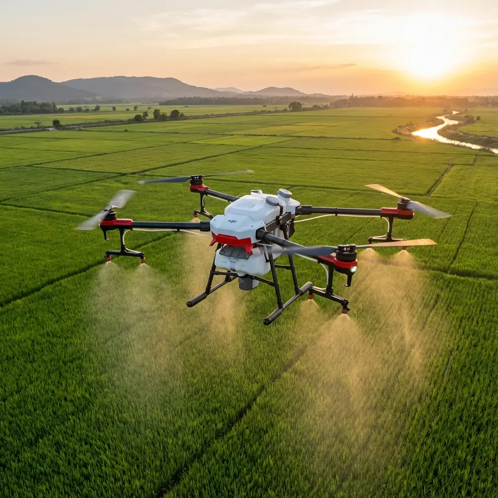
The DJI Agras T50 is usually discussed as an agricultural platform. That is too narrow. In remote power line work, especially in places where access roads are poor and conventional survey mobilization is slow, the T50 deserves a different kind of attention: not as a substitute for a dedicated long-range mapping aircraft in every case, but as a practical aerial tool when the mission demands quick terrain intelligence, localized corridor inspection support, and data capture around difficult tower approaches.
That distinction matters.
Remote power line mapping is rarely one clean task. A utility team may need to verify access conditions, document erosion near tower bases, assess vegetation pressure, compare ground conditions against earlier design assumptions, and capture topographic context around crossings, bends, or unstable slopes. In those moments, a drone that can operate from a rough field setup and hold stable positioning has real value. The Agras T50 enters the conversation not because of a brochure headline, but because the workflow around corridor work increasingly rewards adaptable platforms.
The broader UAV market is heading in exactly that direction. At the 9th World Drone Congress, more than 5,000 products were displayed, all centered on the development of drones and adjacent industrial ecosystems. That number is not just trade-show theater. It signals a maturing environment where airframes, payloads, positioning systems, and data tools are converging. For a reader evaluating the Agras T50 for remote power line mapping, the takeaway is simple: platform versatility now matters almost as much as raw flight performance. A drone’s value is increasingly tied to how well it fits into sensor-driven workflows.
Why the T50 makes sense in remote corridor support
Power line corridors expose a basic problem in field surveying: the areas that need the most attention are often the hardest to reach repeatedly. Steep access tracks, fragmented terrain, scattered structures, and changing surface conditions all slow down traditional collection methods. Engineering literature on UAV mapping has already shown why drone-based digital surveying gained traction. Compared with conventional aerial photography and manual measurement, UAV photogrammetry reduces costs, avoids some of the precision limitations associated with aircraft attitude control, and performs especially well in rapid mapping of smaller areas.
That last point fits remote line work almost perfectly.
A transmission corridor may be long, but the decision-critical zones are often compact: tower pads, crossings, slope failures, drainage channels, temporary access routes, and segments where vegetation or soil movement creates a local risk. The engineering reference material is clear that UAV systems are useful where high-accuracy spatial data is missing, particularly for dispersed or hard-to-reach sites. It even notes that drone-acquired data can support mapping products at scales such as 1:2000, 1:5000, and 1:10000. For utility teams, that translates into a more grounded reality: you can capture enough geometric context to make planning decisions without waiting for a larger survey cycle.
The T50’s practical advantage in this setting is deployment speed. If your team is already field-based and operating in remote terrain, a platform that can be set up quickly for repeated short missions has obvious operational appeal. You are not always trying to map the entire line. Often you are trying to answer a narrow question with confidence.
The right way to think about altitude
If you map power lines in remote areas, flight altitude is not a cosmetic setting. It determines whether your data is useful or merely attractive.
My preferred starting point for Agras T50 corridor support is to think in bands, not a single universal number:
- 30 to 50 meters above ground for tower-base detail, erosion checks, drainage features, and localized access-route assessment
- 50 to 80 meters above ground for short corridor segments where the goal is to balance terrain context with usable detail
- 80 meters and above, only when you need broader situational awareness and the line environment is open enough to preserve data quality
For most remote power line mapping tasks with the T50, around 60 meters above ground level is the best working compromise.
Why 60 meters? Because it usually preserves enough resolution for meaningful interpretation while giving the aircraft a safer buffer over uneven terrain, shrubs, wireside structures, and abrupt slope transitions. In mountain foothills or broken terrain, flying too low creates constant altitude corrections and raises the risk of inconsistent overlap. Flying too high, on the other hand, reduces the detail needed to distinguish early-stage washouts, surface cracking near foundations, access rutting, or vegetation encroachment patterns.
The engineering-source logic supports this middle-ground approach. UAV mapping in construction and infrastructure contexts is valued because it enables fast capture of terrain and object geometry for comparison, planning, and measurement. One cited use is the creation of dense color point clouds and 3D models from multi-angle data capture. That is exactly what corridor teams need around problematic structures. To build a useful surface model or localized reconstruction, your altitude must preserve image geometry and overlap discipline. A moderate operating height does that better than an unnecessarily high pass.
One caution: power line routes are rarely at constant elevation. “60 meters” only works if you are thinking in terrain-relative terms, not launch-point terms. In remote valleys or ridgelines, that difference can ruin a mission.
RTK and centimeter-class expectations
The T50 discussion often gets crowded with buzzwords, but one phrase deserves to stay: centimeter precision.
For corridor mapping, centimeter-class positioning is valuable not because every image needs cadastral-grade rigor, but because infrastructure work depends on repeatability. If you document a tower approach today and revisit after a storm or maintenance cycle, stable positioning helps you compare conditions with much greater confidence. The utility of RTK is less about bragging rights than about reducing ambiguity in change detection.
This becomes especially important when teams are cross-referencing drone outputs with design information or prior site records. The engineering material highlights how UAV-derived 3D capture can be compared against earlier models to identify issues before they become expensive mistakes. In construction that might mean shape deviations. In power line corridors, it can mean platform settling, altered drainage, changed access geometry, or vegetation growth patterns near critical spans.
So if your concern is RTK fix rate in remote operations, do not treat it as a side metric. In isolated terrain, satellite visibility, local obstructions, and workflow discipline directly influence the trustworthiness of your map. A beautiful orthomosaic with weak positional consistency is often less useful than a slightly less polished dataset with reliable control logic behind it.
Sensor thinking: why hyperspectral lessons matter even if your core mission is corridor mapping
This is where the conversation gets more interesting.
The reference material on the Gaiasky mini hyperspectral imaging system is not about power lines. At first glance, it seems unrelated. It is not. It points toward a deeper truth about what industrial drone work is becoming: image capture is moving from visual documentation toward analytical sensing.
The document explains that traditional remote sensing often uses broad spectral bands in the 100 to 200 nm range, which causes the loss of useful information needed for distinguishing ground materials. It also shows that specific spectral combinations can be highly informative. One example: a normalized spectral index built from 550 nm and 450 nm performed well in estimating soil total nitrogen. Another detail is even more operationally significant: soil nitrogen absorption is reported around 510 nm, yet model performance varies substantially with soil type.
What does that mean for someone flying an Agras T50 near remote power lines?
It means that “mapping” should not be reduced to taking pictures of a corridor. Ground conditions under and around line infrastructure can change for reasons that are not always visible in standard RGB imagery. Soil stress, disturbed surfaces, contamination indicators, drainage shifts, and vegetation condition can become easier to interpret when more advanced sensing enters the workflow. The hyperspectral reference also notes that field sampling for soil contamination or heavy metal monitoring is limited by spatial heterogeneity and repeated sampling cost. That is a strong reminder that drones are increasingly valuable because they let teams monitor dynamic conditions over time, not just document a single moment.
Even if your current T50 mission remains RGB- or photogrammetry-based, planning with multispectral or hyperspectral compatibility in mind is smart. Remote power line asset management is gradually shifting from reactive inspection to predictive environmental monitoring. The drone that starts as a corridor mapper may later become a platform inside a broader sensing stack.
Why local calibration still matters
There is another lesson buried in the hyperspectral material that utility teams should not ignore: models built in one region may not transfer well to another. The document states that soil spectral estimation models are heavily influenced by soil type, and that a model built for one area can have major limitations when used on samples from another area. It also cites prediction performance above 0.90 correlation in one spectral modeling approach, while other methods show lower accuracy.
The practical message is straightforward. Remote environments punish assumptions.
If you are using the T50 to map corridor conditions in different geographies, do not assume that one processing recipe or interpretation rule will hold everywhere. Rocky uplands, red clay slopes, reclaimed access roads, wet alluvial crossings, and sparsely vegetated tower pads all reflect differently and behave differently. The aircraft can be consistent; the landscape is not. A disciplined local calibration mindset will usually produce more reliable results than a copy-paste template.
This principle is familiar in spraying as well. Operators understand that nozzle calibration and spray drift control are never one-setting problems; they change with crop, weather, droplet profile, and field geometry. The same operational humility applies to mapping. Standardize your process, yes. But validate your assumptions locally.
Building a corridor workflow that fits the T50
For remote power line mapping, the best T50 workflow is usually modular.
Start with a reconnaissance pass at moderate terrain-relative altitude, often near that 60-meter mark. Use it to understand terrain breaks, identify obstacles, and decide which structures or segments need higher-detail capture. Follow with targeted passes over tower pads, drainage channels, access junctions, or slopes that show instability. Where useful, build 3D outputs rather than relying solely on flat imagery. The engineering source makes this point clearly: multi-angle UAV capture can generate dense point clouds and 3D models that support measurement and comparison. For utility work, that can be the difference between “something looks off” and “the ground surface has shifted enough to trigger action.”
If you are evaluating the T50 for such missions and want to compare field setup options or corridor-specific deployment practices, a quick direct line can save time: message a UAV specialist here.
One more practical note. Remote power line routes punish hardware. Dust, moisture, rough vehicle transport, and repeated field launches are normal. That is why durability features matter more in corridor work than they do in polished demo environments. If your operating conditions include rain exposure, muddy setup zones, and repeated cleaning cycles, environmental protection ratings such as IPX6K become relevant in a very non-theoretical way. A drone that tolerates ugly field conditions supports the real cadence of utility operations.
Where the Agras T50 fits best
The Agras T50 is not the answer to every mapping requirement. It is not the only platform a utility should own, and for long continuous corridor surveying there may be stronger dedicated mapping aircraft depending on sensor payload, endurance, and regulatory constraints.
But that misses the point.
The T50 is compelling when the mission is close to operations: remote, practical, time-sensitive, and tied to local decisions. It fits the work that happens between formal survey campaigns and after broad planning maps have already been made. It is especially useful when utility teams need current site intelligence around difficult access, variable terrain, and infrastructure-adjacent environmental conditions.
The bigger industry trend backs this up. When an event can showcase more than 5,000 drone-related products, what it really reveals is not product abundance but task specialization. Drones are no longer judged only by what category they belong to. They are judged by how effectively they solve a specific field problem. In remote power line mapping, the Agras T50 becomes interesting precisely because the field problem is messy.
And messy problems reward adaptable tools.
Ready for your own Agras T50? Contact our team for expert consultation.