Agras T50 in Windy Corridor Work: A Field
Agras T50 in Windy Corridor Work: A Field-Led Case Study for Long-Line Mapping and Progress Control
META: A practical expert case study on using the Agras T50 mindset for windy long-corridor mapping, drawing on UAV aerial survey methods for catenary-style projects, panoramic control, inspection efficiency, and operational discipline.
Highway and corridor projects punish weak drone workflows.
Not because the aircraft cannot fly, but because long linear jobs expose every gap in planning: too many work points, too much distance between crews, too many updates happening at once, and not enough visibility for managers trying to understand what changed since yesterday. That is exactly why the most useful reference point for an Agras T50 discussion is not a generic drone brochure. It is a practical lesson from UAV aerial survey work in contact network construction, where the core challenge is the same: long routes, scattered sites, difficult access, and management complexity.
The source material is blunt about the problem. Catenary construction projects involve long lines, many construction points, remote geography, difficult execution, and long travel cycles between work areas. Traditional supervision struggles to reflect site reality in time. That matters for anyone thinking about an Agras T50 in windy highway-adjacent operations, because corridor work is rarely defeated by a lack of data. It is defeated by delayed, fragmented data.
Why this matters to an Agras T50 reader
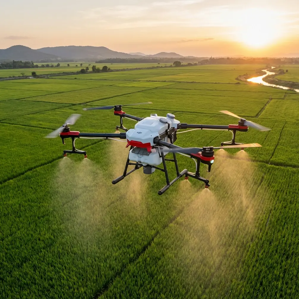
The Agras T50 is usually discussed through an agriculture lens. Fair enough. But readers dealing with windy highway corridors or infrastructure-adjacent land management often need something broader: a drone operating framework that can sustain repeatable low-altitude work over long stretches while feeding decisions back to field teams quickly.
That is where the reference material becomes valuable. It highlights four characteristics of UAV aerial measurement that are operationally decisive:
- high resolution
- large-scale coverage
- low operating cost
- all-weather working capability
Those are not abstract benefits. On a long highway corridor, each one changes how a project is managed.
High resolution means defects, edge conditions, drainage issues, access obstructions, vegetation encroachment, and workfront changes can be interpreted without waiting for another vehicle-based inspection pass. Large-scale coverage matters because corridor jobs are never one-point missions; they are rolling chains of tasks spread across distance. Low operating cost makes repeat inspections realistic rather than occasional. And the all-weather point is especially significant in windy environments, where the goal is not reckless flying but maintaining a disciplined inspection rhythm whenever conditions fall inside safe limits.
The case: windy corridor mapping with an Agras T50 mindset
Let me frame this as a real-world style scenario.
A contractor is supporting a highway-side linear project with multiple active work zones spread over a long alignment. The terrain is uneven. Vehicle access between points is slow. Wind funnels along embankments and open sections, especially after midday. Supervisors need current visual records, measurements tied to progress, and a way to verify whether crews completed the work logged in morning briefings.
This is where an Agras T50 workflow becomes less about “flying a drone” and more about building a repeatable corridor-control system.
The reference source specifically describes low-altitude aerial measurement as a tool to assist construction sites and deliver full-line panoramic control, inspection, and measurement. That phrase—full-line panoramic control—is the real prize. On long corridor work, leadership does not just need isolated imagery. They need a coherent visual thread along the route.
With the right mission planning, the T50 can be part of that discipline. Swath width and route spacing must be adjusted for wind, not copied from calm-day assumptions. If you are collecting corridor imagery or visual condition data in gusty conditions, overlap margins should be treated as operational insurance, not optional perfectionism. A wider buffer between expected and required coverage helps preserve useful continuity when crosswinds begin nudging the aircraft off its ideal line.
Wind changes everything, especially data trust
Plenty of operators talk about windy missions as a flight challenge. It is also a data integrity challenge.
When a corridor mission is flown in unstable air, three things tend to break first: consistency, geospatial confidence, and operator judgment. That is why RTK fix rate deserves attention even in conversations that start with a platform like the T50. If the workflow depends on repeat visits to verify progress or compare conditions over time, centimeter precision is not a luxury. It is the difference between spotting a real shift and chasing a false one caused by poor positional repeatability.
The source document did not use the phrase RTK, but it did emphasize accurate grasp of construction progress and supervision of construction quality through UAV-enabled visualization. To achieve that in modern corridor operations, RTK-backed repeatability is the practical bridge. Without it, “progress tracking” can devolve into visually similar images that do not line up well enough to support confident decisions.
In windy work, I advise teams to watch RTK fix stability before worrying about speed. A slightly slower mission with a reliable fix rate is far more valuable than a fast flight that creates doubtful measurements and messy reconstruction.
The overlooked safety detail: cleaning before takeoff
Most discussions about safety features begin with obstacle sensing or route logic. That skips a more basic truth: dirty hardware weakens smart systems.
Before any pre-flight in dusty roadside or agricultural-adjacent environments, one cleaning step matters more than people admit. Wipe down the sensing surfaces, camera windows, and any exposed vision-related components before power-up and calibration checks. If the aircraft has been parked after a previous muddy or chemical-heavy operation, inspect nozzle areas and surrounding structures as well. On multipurpose field days, residue buildup can obscure surfaces, affect cooling flow, and undermine the reliability of safety systems that depend on clean sensor input.
This sounds minor until wind enters the picture. In gusty conditions, the flight control system already has more work to do. You do not want degraded sensor clarity, dried deposits, or grime adding ambiguity to the aircraft’s environmental awareness. The pre-flight cleaning step is one of the cheapest ways to preserve trustworthy behavior from intelligent safety functions.
If your team wants a practical setup checklist for this kind of corridor work, I usually suggest sharing field notes directly through this WhatsApp line for mission planning support.
Panoramic control is more valuable than isolated mapping
The source material makes a strong point that UAV operations can support panoramic control of construction sites and the entire line. That deserves emphasis because many crews still fly as if each sortie is a stand-alone event.
It should not be.
For long infrastructure-adjacent routes, the value comes from stitching site-level observations into a route-level management picture. A manager does not just need to know that one segment is complete. They need to see whether access roads are blocked two kilometers ahead, whether temporary stockpiles have moved into a drainage path, whether slope protection work is lagging behind, or whether wind has increased dust movement around exposed sections.
This is where visual data paired with progress context becomes powerful. The source also mentions using aerial capture of real-time site dynamics and virtual-reality-based visualization systems to understand construction progress accurately. Whether or not a team uses full VR, the principle stands: imagery should feed a navigable visual management layer, not sit in disconnected folders.
An Agras T50-based workflow can support that larger management objective when flights are standardized. Same route logic. Same control points. Same altitude strategy where safe and appropriate. Same naming conventions. Same post-flight review sequence. The aircraft is only one part of the system; repeatability is the real product.
Corridor operations reward labor savings, but only if the workflow is structured
One of the strongest practical claims in the reference is that applying UAV methods to construction and maintenance can save labor and material resources while improving construction quality and line safety. It even points to 24-hour uninterrupted working capability as an advantage in operational terms.
No, that does not mean crews should run nonstop without human limits. It means the system itself can support continuous project visibility across shifts, handovers, and dispersed locations. That distinction matters.
For highway-side and long-corridor work, labor savings happen in three specific ways:
Fewer repeated drive-through inspections
Long travel cycles between points were called out directly in the source. Drone-based visual confirmation reduces how often personnel need to physically revisit segments just to verify status.Faster exception management
When a route-level dataset reveals only three problematic zones out of twenty, field supervisors can send people precisely where they are needed.Better quality feedback loops
Construction quality improves when issues are seen early enough to correct before they propagate down the line.
This is where the T50 becomes more than a platform choice. It becomes a management accelerator.
Why the market context strengthens this use case
The second source is not about Agras T50 specifically, but it helps explain why these workflows are becoming normal rather than niche. The report projected the global drone market at roughly 70 billion dollars by 2025 and highlighted strong momentum in commercial UAV adoption. It also cited Chinese policy expectations for fast civil drone industry growth, with annual expansion above 40% in the period referenced.
The operational significance is clear. Commercial drone use is moving toward specialization and repeatable industrial process integration. Corridor mapping, inspection support, and visual progress control are not side experiments anymore. They sit inside a larger commercial UAV shift where end users expect measurable workflow gains, not just attractive footage.
For an Agras T50 operator, that trend matters because platform decisions now live inside broader enterprise expectations: cleaner reporting, more dependable revisit accuracy, and better integration between field capture and management action.
A note on multispectral, spray drift, and nozzle calibration
These terms enter T50 conversations often, and they should be handled with discipline.
If your corridor mission includes vegetation management assessment near highway shoulders, drainage channels, or rights-of-way, multispectral data can add value by showing stress patterns that standard visible imagery may understate. But it only helps if the mission design supports consistent revisit conditions and if your positioning quality is high enough to compare sections confidently.
Spray drift and nozzle calibration belong in the conversation whenever the aircraft is used in vegetation-treatment contexts rather than pure mapping. Windy conditions raise the threshold for operational caution immediately. Calibration should be verified before the mission day, and again if equipment has been cleaned, reconfigured, or stored after prior use. A corridor environment magnifies drift risk because there are more edge conditions: roads, drainage structures, barriers, nearby traffic zones, and mixed surfaces that do not forgive sloppy application planning.
Even in a mapping-centric article, this matters because multipurpose operators often switch between documentation and treatment support. The safest teams do not carry assumptions from one mode into the other.
What operators usually get wrong
The common mistake is thinking the aircraft solves the corridor problem by itself.
It does not.
The source material points to something more mature: drone-based measurement and imaging support a management system that can monitor the whole line, reflect real site conditions quickly, and improve safety and quality outcomes. That is a workflow claim, not a hardware boast.
So if you are evaluating the Agras T50 for windy highway-style corridor operations, ask harder questions than “Can it fly the route?”
Ask these instead:
- Can the mission design preserve useful overlap and continuity in wind?
- Can your team maintain a strong RTK fix rate for repeatable visits?
- Are pre-flight cleaning and sensor checks standardized, especially after dusty or residue-heavy days?
- Is the output being used for panoramic line control, or just archived as media?
- Can managers convert the flight data into same-day decisions?
Those answers determine whether the operation creates real value.
The practical takeaway
The strongest lesson from the reference material is not technological novelty. It is managerial leverage.
UAV aerial survey methods proved attractive in long, difficult, multi-point construction settings because they bring timely visibility to places where traditional supervision lags. They support panoramic oversight, measurement, inspection, and faster recognition of what is actually happening on the line. They can save labor, reduce wasted site visits, and improve quality and safety when integrated correctly.
That is exactly the lens through which the Agras T50 should be judged for windy corridor work.
Not as a flying gadget. As a field instrument for making long-route operations more legible, more repeatable, and more accountable.
Ready for your own Agras T50? Contact our team for expert consultation.