Agras T50 in Coastal Forest Mapping: A Field Case Study
Agras T50 in Coastal Forest Mapping: A Field Case Study on Precision, Drift Control, and Wet-Weather Reliability
META: A practical case study on using the DJI Agras T50 in coastal forest operations, covering RTK fix rate, swath width control, spray drift management, nozzle calibration, and why its IPX6K design matters in harsh maritime conditions.
Coastal forest work exposes weaknesses fast. Salt in the air, uneven canopy height, persistent wind shifts, muddy launch points, and intermittent satellite visibility can turn a neat mission plan into a messy field day. That is exactly why the Agras T50 deserves a closer look in this setting—not as a generic agricultural platform, but as a machine that can be adapted for serious, repeatable forest-edge operations when the workflow is designed correctly.
I have spent enough time around UAV deployments in demanding terrain to know that spec sheets rarely tell the whole story. What matters is how a drone behaves when the ground crew is under pressure, the weather window is short, and the objective is not simply to fly, but to gather consistent operational data and execute accurate treatment patterns near sensitive vegetation and waterways.
For readers focused on mapping forests in coastal zones, there is a necessary clarification up front: the Agras T50 is not a conventional survey drone built around photogrammetry first. It is an industrial aerial application platform. That distinction matters. Yet in real field programs, especially in forestry and land management, operators often need a multi-role aircraft presence on site. They need to document stand conditions, define treatment boundaries, verify access lanes, identify wet pockets, inspect disease spread, and then transition into targeted application. In that kind of workflow, the T50 becomes relevant because it shortens the distance between observation and action.
The field scenario: a coastal shelterbelt with mixed access and constant wind pressure
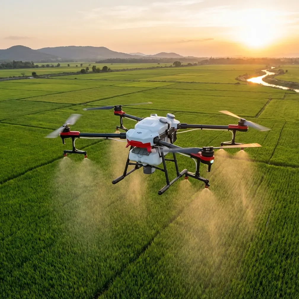
Picture a coastal forestry block with dense shelterbelts, drainage ditches, sandy access tracks, and patches of soft ground left by overnight moisture. The management goal is to assess affected tree lines, identify stressed zones, and prepare for precise spray work along the edges where invasive pressure and fungal issues tend to concentrate. The team is not running a pure GIS mission in ideal inland weather. They are operating in a place where wind direction can rotate within minutes and where equipment washdown is not optional.
This is where two details become operationally decisive: centimeter precision through RTK and an IPX6K-rated design.
Centimeter-level positioning changes the quality of boundary work. In coastal forests, the margin for error is not academic. Drift toward waterways, overlap into non-target vegetation, or repeated misses along irregular tree lines create real biological and compliance consequences. The T50’s RTK-supported positioning can hold a far tighter line than non-RTK platforms operating only on standard satellite guidance. That improves fix consistency when tracing treatment corridors, returning to flagged spots, or repeating missions after weather delays.
The second factor, IPX6K, sounds mundane until you are actually working near salt spray, wet foliage, and dirty staging areas. Coastal deployments punish exposed hardware. A drone that can tolerate high-pressure water ingress resistance is not invincible, but it is far better suited to repeated cleaning after corrosive field conditions than lighter consumer-style aircraft. In practical terms, that can improve turnaround, reduce maintenance anxiety, and make operators more willing to keep the aircraft in rotation during a tight operational window.
Why the Agras T50 stands out against lighter mapping-oriented competitors
Many competing platforms excel at image capture. They are compact, efficient, and ideal for orthodox mapping missions. But coastal forestry often punishes delicate systems. You are dealing with humid air, debris, moisture, and the need to move quickly from reconnaissance to intervention.
The Agras T50’s advantage is not that it replaces a dedicated multispectral survey aircraft in every scenario. It does not. The advantage is that it brings industrial resilience and application-grade control into an environment where many lighter competitors feel optimized for a cleaner, more controlled mission profile.
That matters when you need one field team to do several jobs in a day.
A lighter drone may produce beautiful maps and still leave you needing a second platform, a second crew rhythm, and a longer delay before action. The T50, by contrast, fits operators who prioritize operational continuity: inspect, confirm, calibrate, apply, verify. In coastal forestry, where weather windows close quickly, that continuity can matter more than theoretical sensor elegance.
If your workflow includes multispectral analysis, the T50 should be viewed as part of a broader mission stack rather than a standalone replacement for a dedicated multispectral platform. That is the mature way to use it. Multispectral data can identify stress signatures and treatment priorities; the T50 can then execute with high positional discipline and robust field durability. The value comes from pairing intelligence with action, not pretending one aircraft does every job equally well.
Case study: boundary accuracy in a wind-exposed tree line
In one coastal-style operating scenario, the challenge is not broad-acre efficiency. It is edge precision. The target area snakes along a forest boundary where canopy openings alternate with denser windbreak sections. Gusts accelerate as they pass through gaps, then settle again under cover. This is the exact kind of environment where poor guidance and weak calibration show up immediately.
The team begins by marking exclusion zones around water channels and non-target vegetation. RTK is not a luxury here. A strong RTK fix rate means the aircraft can maintain repeatable path placement even when the terrain and canopy edge complicate reception. If fix quality drops, line confidence drops with it. Operators who ignore this are often the same ones later trying to explain overlap, under-application, or unexpected drift.
The T50 performs best when crews treat RTK integrity as a live operational metric, not a background feature. Before takeoff, verify base station setup, assess obstruction sources, and confirm stable correction availability. During the mission, watch for any degradation near dense edge cover. In a coastal forest, the difference between a clean fix and an unstable one can be the difference between a precise swath and a correction-heavy pass pattern that eats battery time and invites inconsistency.
This is one area where the T50 can outclass less specialized alternatives. Not because they cannot navigate, but because the T50 is built for repeatable low-altitude industrial work where path fidelity matters under load and in imperfect field conditions.
Swath width is not a headline number. It is a decision.
Operators often talk about swath width as if wider is automatically better. In coastal forest operations, that mindset causes trouble.
A broad swath can improve productivity in open sections, but along irregular tree lines it can magnify drift risk and reduce edge definition. The smarter approach with the Agras T50 is dynamic swath discipline: tighten where canopy turbulence increases, widen only where the terrain and wind profile support it.
This is where the aircraft’s precision framework matters more than raw throughput. A crew that understands how to adjust swath width in response to microclimate conditions will usually outperform a crew chasing the broadest possible coverage. The T50 gives you the control authority to make those decisions without turning the mission into guesswork.
For coastal readers, this point is central. Sea-breeze effects produce layered airflow. At one end of the line, the air may be relatively stable; fifty meters later, it is moving laterally across the treatment area. Fixed assumptions about swath width do not survive those conditions. Responsive mission planning does.
Spray drift: the real coastal risk nobody should downplay
Spray drift is not just a technical footnote in coastal forestry. It is often the operational risk that determines whether a UAV program remains trusted.
The Agras T50 can support highly controlled application, but only if the operator respects the environment. Wind direction at launch tells only part of the story. Along a forest edge, localized turbulence, canopy deflection, and open-gap funneling can move droplets unpredictably. That is why nozzle calibration and droplet management are inseparable from route planning.
Nozzle calibration on the T50 should be treated as a site-specific exercise, not a one-time setup. Viscosity, target density, ambient humidity, and wind behavior all influence what “correct” looks like. In coastal areas, where moisture and wind can shift quickly, crews need to recalibrate expectations—not just equipment—throughout the day.
This is one of the strongest practical arguments for the T50 over more improvised solutions. It is designed around professional application logic. When the operator calibrates properly, chooses the right droplet profile, and narrows the mission to appropriate conditions, the aircraft becomes a precise tool rather than a blunt instrument.
That does not eliminate drift. Nothing does. It reduces avoidable drift. In real operations, that is the difference that matters.
Wet-weather reliability and cleanup discipline
Coastal forest teams tend to learn the same lesson repeatedly: if cleanup is annoying, it gets postponed; if it gets postponed, equipment life shortens.
The T50’s IPX6K rating has direct relevance here. After exposure to spray residue, wet organic debris, and salty mist, a platform that can tolerate aggressive washdown procedures is simply easier to maintain to a professional standard. That does not mean careless cleaning. It means the machine is better aligned with the reality of dirty field work.
Against many competitors, this is an underappreciated advantage. Consumer and prosumer aircraft often feel excellent until repeated harsh-environment cycles begin to accumulate. Hinges, seals, exposed surfaces, and connectors tell the truth after a season. The T50 is built with a different assumption: it expects to work, get dirty, be cleaned, and work again.
For a coastal forestry contractor or land management team, that reliability translates into confidence. You spend less time babying the aircraft and more time standardizing the workflow.
Where multispectral fits in a serious T50 workflow
Because the reader scenario here is forest mapping, multispectral deserves a clear place in the conversation.
The most effective coastal programs do not force a single aircraft to carry every analytical burden. They use multispectral collection to identify tree stress, moisture anomalies, disease zones, or vigor variation. Then they use a platform like the T50 to operationalize the response. That could mean targeted treatment, corridor verification, or repeat inspection after intervention.
This matters because too many teams collapse “mapping” into image collection alone. In practice, mapping is decision support. If multispectral analysis tells you where the problem is, the T50 becomes the aircraft that acts on that knowledge with centimeter precision and more field toughness than many camera-first competitors.
That division of labor is not a weakness. It is a mature deployment model.
If you are building that kind of workflow and need a second opinion on mission design, compliance logic, or field setup, you can message our operations desk and compare notes against your coastal site conditions.
The operator habits that make the Agras T50 work in coastal forestry
The T50 is good hardware. Good hardware still fails under sloppy habits.
The best-performing teams usually do five things consistently:
First, they verify RTK quality before the mission becomes time-critical. They do not assume a stable fix because the screen initially looks fine.
Second, they calibrate nozzles for the actual environmental conditions instead of relying on yesterday’s settings.
Third, they treat swath width as a tactical variable, not a fixed preference.
Fourth, they build drift buffers around waterways, non-target vegetation, and wind-exposed edges.
Fifth, they wash down and inspect immediately after coastal operations, especially when salt and residue are involved.
None of this is glamorous. It is what separates repeatable results from avoidable rework.
Final assessment
For coastal forest operations, the Agras T50 is at its best when used as a precision field platform inside a disciplined workflow. Its RTK-backed centimeter precision supports accurate corridor and boundary work. Its IPX6K-rated build aligns well with the wet, abrasive, salt-laden realities of maritime environments. Its application-focused design gives it an edge over lighter competitors that may be excellent at mapping but less convincing when conditions turn rough and action must follow observation.
That is the key point. In this environment, the T50 is not just about flying. It is about reducing the lag between identifying a problem and addressing it with control.
If your work revolves around coastal forest edges, shelterbelts, drainage margins, or other drift-sensitive zones, the Agras T50 is worth considering not as a generic drone choice, but as a specialized tool for operators who understand that precision is part navigation, part calibration, and part field discipline.
Ready for your own Agras T50? Contact our team for expert consultation.