Agras T50 for Coastal Field Mapping: What Actually Matters
Agras T50 for Coastal Field Mapping: What Actually Matters in Wind, Salt, and Signal Noise
META: Expert analysis of Agras T50 use in coastal field mapping, with practical guidance on RTK reliability, antenna positioning, spray drift awareness, nozzle calibration, swath width, and centimeter-level workflow decisions.
By Dr. Sarah Chen
The most useful way to think about the Agras T50 in a coastal mapping workflow is not as a flying gadget, but as the latest expression of a much older UAV story.
UAV stands for Unmanned Aerial Vehicle. That term sounds routine now, yet the category itself began as a much rougher idea. The concept first emerged in the early 20th century, around the First World War, when aircraft automation was still primitive and largely experimental. By the Second World War, unmanned aircraft development accelerated, though the machines were still used mainly for training roles and as artillery targets. That history matters for one reason: UAVs did not become valuable because they were novel. They became valuable because each generation solved a practical operational problem better than the last.
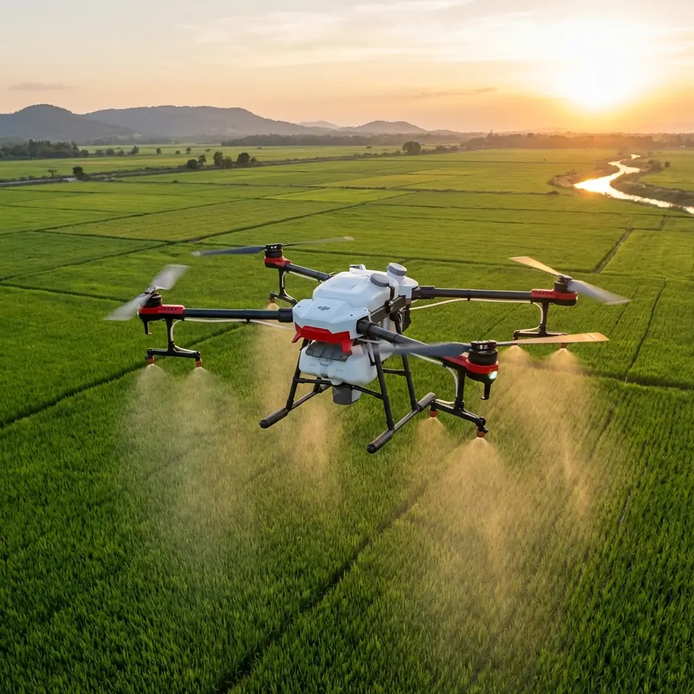
For growers and service providers working near the coast, the Agras T50 sits squarely in that tradition. The problem is not simply “how do I fly over a field?” The real problem is how to map and treat land accurately when the environment keeps trying to corrupt your data. Coastal farms impose three recurring penalties on drone work: unstable wind profiles, reflective water-adjacent terrain that can complicate positioning and perception, and corrosive exposure that punishes weak hardware choices. If your workflow depends on consistent swath width, repeatable overlap, and dependable centimeter precision, those penalties show up fast.
That is where a disciplined T50 setup matters more than marketing claims.
The Coastal Mapping Problem Is Not One Problem
People often talk about coastal operations as if salt air is the whole story. It is not.
The first issue is wind asymmetry. Inland breezes can be annoying; coastal airflow can shift shape across a single block. A field edge near a levee, tidal channel, or open shoreline may experience a very different lateral push than the center of the parcel. If you are flying a structured grid, those micro-shifts can distort line spacing, change effective overlap, and create small but expensive errors when you later compare imagery, spray routes, or treatment records.
The second issue is RTK consistency. In open farm country, operators tend to assume a clear sky means easy positioning. Near the coast, that assumption can break down. Signal reflections, long flat surfaces, embankments, nearby structures, and moisture-heavy conditions can all interfere with a stable RTK fix rate. A drone may still fly, but mapping-grade confidence is another standard entirely. When you are trying to document drainage patterns, weak plant zones, or boundary-adjacent treatment areas, “close enough” is not enough.
The third issue is operational crossover. The Agras T50 is associated first with agricultural application, not pure survey work, so mapping teams sometimes underestimate how tightly imaging and application performance are linked. In reality, the quality of your field map directly affects how you plan later spray passes, assess spray drift risk, and refine nozzle calibration strategy. A bad map can turn into a bad agronomy decision.
Why the Agras T50 Fits This Use Case
The T50 makes sense in coastal agriculture not because it replaces a dedicated survey platform in every scenario, but because it can anchor a broader decision loop: identify field variability, understand boundaries, plan safe and efficient coverage, then execute with less guesswork.
That role only works if the aircraft is treated as a precision system.
The phrase “centimeter precision” gets used casually in drone discussions, but in coastal farming it has a very specific operational meaning. It means your mapped edge should remain the same edge on the next visit. It means a saline patch identified today should line up with the same patch next week. It means a turn at the edge of a narrow field should not drift into a drainage ditch simply because wind and positioning quality were judged loosely. Precision is not an abstract technical achievement. It is the difference between repeatable management and field-by-field improvisation.
For that reason, RTK fix rate deserves more attention than many operators give it. A high fix rate is not just about a cleaner track log. It improves confidence in line placement, overlap consistency, and repeat missions. In coastal fields where boundaries may be irregular and neighboring surfaces include water, roads, or embankments, that confidence compounds over time.
Antenna Positioning Advice for Maximum Range and Stability
If you want one field habit that pays off disproportionately, it is intelligent antenna placement.
Too many crews place the base or communication antenna wherever unloading is easiest. That is a mistake, especially on coastal ground. For maximum range and better link stability, position the antenna in the highest unobstructed point available within the operating area, with a clear line of sight across the entire field. Avoid placing it beside vehicles, corrugated sheds, irrigation hardware, or metal fencing. Those surfaces can reflect or partially block signal paths in ways that are hard to diagnose once the mission starts.
A few practical rules help:
- Keep the antenna away from large metal objects and rooflines.
- Do not set it low beside a seawall, berm, or machinery stack if a slightly elevated site is available.
- If one side of the field faces open water and the other faces buildings or tree rows, bias antenna placement toward the side that preserves the cleanest full-field line of sight.
- Maintain physical separation between the antenna and other active electronic equipment when possible.
- Before committing to a full mission, check fix status and link quality while hovering at multiple field edges, not just at takeoff.
This is one of those details that sounds minor until it saves an entire day. Coastal signal environments are often “good enough” until the aircraft reaches the far corner, drops to marginal quality, and forces a restart or leaves you with uneven data. If your team wants site-specific positioning help, I usually suggest starting with a quick field discussion rather than troubleshooting after a failed run: message our UAV specialists here.
Mapping Quality Shapes Spray Quality
Even when the immediate task is mapping, agronomic value comes later. That is why operators should think about spray drift, nozzle calibration, and swath width during the mapping phase rather than after it.
Take spray drift first. In coastal regions, drift risk is rarely uniform. Field orientation relative to prevailing sea breeze, crop height, open drainage corridors, and neighboring sensitive zones all matter. A clean map helps identify where the same application settings should not be used across the entire block. If your mapping pass reveals exposed edges, narrow tapering corners, or abrupt transitions to water channels, that information should shape how you build later spray plans.
Nozzle calibration belongs in the same conversation. Calibration is often treated as a bench task, but its operational value depends on where and how the drone will fly. If your coastal map shows long uninterrupted passes, nozzle and flow settings may be optimized differently than in fragmented plots with frequent acceleration, deceleration, and turning. Mapping tells you whether your theoretical output profile matches the geometry of the real field.
Then there is swath width. On paper, a broad swath can look efficient. In a coastal environment, a wide pass in unstable crosswind can produce inconsistent coverage or force correction behavior that erodes efficiency anyway. Mapping data helps determine where a narrower, more controlled pattern will outperform a nominally faster approach. Efficiency is not just hectares per hour. It is hectares completed correctly the first time.
Multispectral Thinking, Even If That Is Not Your First Tool
Not every T50 deployment will involve multispectral payload strategy directly, but coastal operators should still think in multispectral terms: not just where the crop is, but where stress is beginning to separate from appearance.
Why? Because coastal fields often hide problems until they are advanced enough to be visible from the ground. Salt stress, drainage inconsistency, and edge effects can create subtle variation patterns before they become obvious in canopy color or vigor. Even if your immediate workflow relies on standard visual mapping and RTK-guided field planning, the logic behind multispectral analysis is still useful. You are looking for patterns, thresholds, and repeatability.
That perspective makes the T50 more valuable. It becomes part of a monitoring system rather than a one-off flight tool. The better your base map and positional consistency, the easier it is to compare visual signs, agronomic notes, and later imagery products from other platforms.
Hardware Resilience Matters More Near the Coast
The mention of IPX6K is not a decorative spec in this context. Near the coast, durability standards have practical consequences.
Salt-laden moisture reaches connectors, housings, exposed joints, and maintenance points faster than many teams expect. An aircraft used inland and the same aircraft used near tidal flats or sea-facing vegetable ground do not age the same way. Protection against water intrusion and harsh washdown conditions contributes to reliability, but only if maintenance discipline follows. After coastal operations, crews should assume residue accumulation even when surfaces look clean.
That matters because mapping failures are not always dramatic. Sometimes the issue is a slowly degraded connector, inconsistent sensor behavior, or an intermittent communication problem that only appears under field stress. A robust protection standard gives you margin, not immunity. The T50’s relevance in this environment improves when the operator respects that distinction.
A Practical Problem-Solution Workflow for Coastal Fields
Here is the workflow I recommend for T50 teams mapping coastal farmland.
1. Define the actual agronomic question
Do not launch simply to “map the field.” Decide whether the mission is about drainage, stand variability, treatment planning, access routes, or edge-risk assessment. The mission objective determines acceptable precision and overlap tolerance.
2. Establish your RTK confidence before full coverage
A strong RTK fix rate should be verified at multiple points, especially distant corners and shoreline-facing edges. A stable lock at takeoff tells you very little about the rest of the parcel.
3. Place antennas as if signal quality will be your bottleneck
Because in coastal fields, it often is. Elevation and line of sight are not optional refinements.
4. Fly for repeatability, not bragging rights
The fastest possible mission profile is usually not the most useful if wind shear is changing across the field. Hold a flight plan that preserves consistency in overlap and edge definition.
5. Interpret the map with later application in mind
Mark zones where spray drift risk rises, where narrower swath width may be prudent, and where nozzle calibration assumptions may need adjustment.
6. Maintain the aircraft like a coastal machine
Post-flight cleaning, inspection, and connector checks are part of data quality control, not just equipment care.
The Bigger Meaning of the UAV Story
The original UAV story began with experimentation in the early 1900s and accelerated during wartime development, when unmanned aircraft were still limited in function and far from the refined civilian tools we rely on now. That long arc is worth remembering because it explains what makes modern platforms such as the Agras T50 useful: not the fact that they are unmanned, but the fact that they convert advanced systems into repeatable field outcomes.
In coastal agriculture, repeatability is hard won. Wind pushes. Salt corrodes. Signal conditions can look excellent until they do not. A mapping mission that ignores those realities produces pretty visuals and weak decisions. A mapping mission built around RTK integrity, thoughtful antenna positioning, realistic swath assumptions, and agronomic follow-through becomes something more valuable. It becomes a management instrument.
That is the real standard for the Agras T50 in coastal field mapping. Not whether it can fly the route, but whether the route produces data you can trust when the field gets difficult.
Ready for your own Agras T50? Contact our team for expert consultation.