Agras T50 for High-Altitude Coastline Mapping
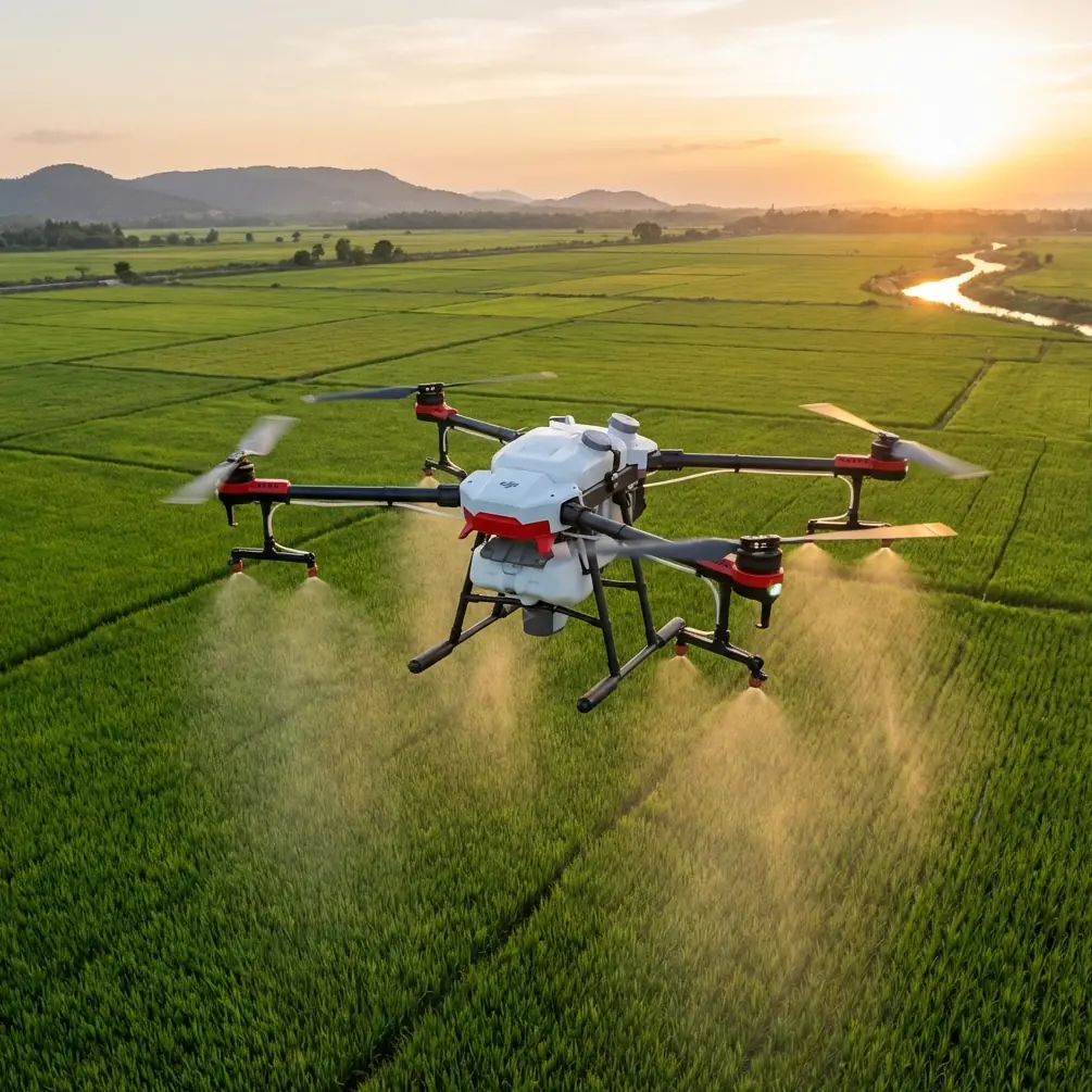
Agras T50 for High-Altitude Coastline Mapping: What Actually Works in the Field
META: Expert practical guide to using the DJI Agras T50 for high-altitude coastline mapping, with RTK setup, drift control, nozzle calibration logic, weather limits, and sensor-led field tactics.
Coastline work punishes bad assumptions.
At sea level, mapping is already a negotiation with glare, wind, salt, shifting edges, and unreliable visual references. Move that same job to higher elevation along cliffs, headlands, or mountain-backed coastal terrain, and the margin for error narrows further. GNSS geometry changes by the minute as the aircraft passes rock faces. Wind rolls upward off the surf, then folds back across the slope. Moisture hangs in the air even when the sky looks clean. The pilot is not just flying a route. The pilot is managing interference, terrain compression, and a moving atmospheric boundary.
That is where the Agras T50 becomes interesting.
Not because it was originally framed around broad-acre operations, but because its core hardware profile lends itself to difficult outdoor work when the operator understands what to repurpose and what to restrain. The platform’s high-thrust propulsion, robust airframe, and sealed construction matter more in exposed coastal environments than many people realize. So does one practical detail that often gets buried in spec-sheet reading: an IPX6K protection level changes the maintenance conversation in salt-heavy operations. It does not make the aircraft invulnerable to marine corrosion, but it does mean spray, mist, and washdown conditions are less likely to become immediate mission-ending problems when basic post-flight hygiene is handled properly.
For high-altitude coastline mapping, the Agras T50 is not a plug-and-play survey craft. It is a platform that can be made operationally effective if the mission is designed around its strengths and the risks are acknowledged early.
The real problem: coastline mapping at altitude is a stability problem before it is a data problem
People often frame mapping as a camera problem. On rugged coasts, that is backwards.
The first challenge is holding a predictable line over unstable air. High cliffs create turbulent layers that can push the aircraft sideways just as it reaches a planned turn point. A second issue follows immediately: even if the drone remains airborne comfortably, the flight path may drift enough to weaken data consistency. Along narrow coastal shelves, that can distort overlap, reduce edge confidence, and create headaches during downstream analysis.
This is where RTK performance stops being a luxury and becomes core mission infrastructure. A strong RTK Fix rate is the difference between a route that repeats cleanly and one that slowly wanders across multiple passes. If your goal is centimeter precision near erosion boundaries, tidal structures, or vegetation transitions, a float solution or intermittent lock is not just a technical nuisance. It undermines the entire premise of repeatable shoreline monitoring.
With the Agras T50, I advise operators to think about RTK health as a live operational metric, not a setup checkbox. On high coastal ridges, the aircraft may have excellent sky visibility one moment and partial masking the next as it tracks beside steep rock. That means mission design should prioritize line orientation and base-station placement that preserve satellite geometry where the coast bends or rises sharply. If the RTK Fix rate degrades at the same two corners every flight, that is not bad luck. That is route design telling you where it is weakest.
Why spray-drone thinking still matters in a mapping scenario
The T50 carries agricultural DNA, and that is useful here.
A coastline mission at altitude is deeply sensitive to drift, only in this case the drift may not be chemical movement alone. It may be aerosolized salt, moisture, or rotor-induced disturbance near fragile vegetation, nesting areas, or wet rock surfaces where traction and reflectance both matter. The operational language of spray drift therefore still belongs in the planning phase even if the primary job is data capture rather than application.
Why? Because drift analysis teaches discipline about wind layers, droplet behavior, nozzle state, downwash, and lateral displacement. Those same habits improve mapping safety.
For example, if a pilot already understands how crosswinds alter spray pattern integrity across a given swath width, that pilot is usually better prepared to predict how the aircraft will translate over a coastal escarpment during a parallel tracking run. In field terms, a widening spray footprint and a widening route deviation are often symptoms of the same local air instability. One is visible in droplets. The other is visible in flight logs.
That is also why nozzle calibration deserves a place in this conversation even when the day’s primary objective is mapping. Many operators switch mission types quickly and assume the spray system can be ignored if it is not active. That is careless. A mismanaged or partially contaminated nozzle assembly can still affect cleanliness, residual fluid behavior, and preflight confidence, particularly in salty, windy conditions where minor leaks or deposits become larger maintenance issues. If the aircraft is being used across mixed operations, disciplined nozzle calibration and post-rinse verification protect reliability. The immediate gain is mechanical consistency. The larger gain is trust in the platform before sending it low along a cliff edge or out over a surf line.
A field example: when the sensors matter more than the map
On one coastal survey exercise at elevation, the most valuable “obstacle” was not geological at all. A pair of gulls rose suddenly from a ledge, but the more memorable moment came seconds later when a sea eagle cut across the headland from behind the operator’s blind side. The aircraft’s sensing and pilot warning response created the hesitation needed to hold position and avoid pressing into the bird’s path.
This is not a sentimental wildlife story. It is an operational lesson.
Wildlife encounters on coastlines are common, especially near cliffs, marsh edges, and fish-rich inlets. A platform operating near bird traffic must be managed with sensor awareness, conservative route timing, and enough altitude flexibility to pause safely without losing mission control. When people discuss coastal mapping, they usually fixate on water and terrain. In practice, avian activity can be the most dynamic hazard in the entire airspace.
The significance for T50 operators is straightforward: obstacle awareness and cautious route spacing should be treated as mission-preservation tools, not convenience features. If the aircraft can detect, alert, and buy the pilot time, that time must be used intelligently. The correct response is often to break the run, reset the line, and resume once the airspace clears. Protecting data continuity never justifies pressuring wildlife.
Building a coastline workflow around the T50
The best high-altitude coastline workflow with an Agras T50 follows a problem-solution logic.
Problem 1: Wind shear ruins route consistency
Solution: Fly shorter segments and reduce your appetite for wide coverage.
Many pilots want to maximize area in every sortie. On exposed coasts, that instinct works against quality. Keep legs shorter where terrain changes rapidly. The issue is not battery anxiety alone. It is atmospheric variability. Wind at the launch point may differ sharply from wind halfway down a cliff band.
This is where swath width planning becomes more than a spray parameter. Even in a mapping-oriented flight concept, a narrower effective corridor gives you tighter control over overlap and a better chance of preserving positional repeatability. A broad route may look efficient on paper, but if edge fidelity falls apart due to sideways movement, the “saved” time returns as rework.
Problem 2: RTK degradation near rock faces
Solution: Treat base placement as part of mission geometry.
A surprising number of coastal operators still place their RTK infrastructure for convenience rather than line quality. If your station setup favors easy access but produces compromised angles at the very sections you need to revisit month after month, you are trading field comfort for long-term dataset inconsistency.
The answer is simple in principle: place and test for repeatability, not convenience. Watch the RTK Fix rate before the critical leg begins, and do not normalize weak fixes just because the aircraft remains controllable. If the objective is shoreline change detection, “close enough” positioning is often operationally useless.
Problem 3: Salt and moisture erode reliability over time
Solution: Use the T50’s sealed build wisely, not lazily.
Again, IPX6K matters. On a coastal aircraft, environmental sealing buys resilience during exposure and cleanup. But it does not eliminate the need for a salt-control routine. Rinse discipline, connector inspection, payload-area drying, and careful storage are what convert a ruggedized drone into a durable one. Operators who skip this because the aircraft is weather-resistant usually discover the cost later, not immediately.
Problem 4: Coastal vegetation analysis lacks depth
Solution: Add a multispectral logic layer where the mission justifies it.
The T50 is not commonly the first aircraft people name when discussing scientific shoreline classification. But if your workflow includes external payload strategy or a broader ecosystem-monitoring architecture, a multispectral layer can be decisive. Along high-altitude coasts, visible imagery often struggles to separate stressed vegetation from salt-burned ground cover or to clarify moisture-driven transitions in dune or bluff ecology. Multispectral interpretation helps distinguish what the eye alone tends to flatten.
That matters if your mapping goal includes more than edge tracing. Shoreline management increasingly depends on understanding the interface between rock, water, and living cover. Vegetation stress patterns can tell you where salt intrusion, runoff concentration, or wind exposure is shifting before a major failure appears in topographic form.
How I would brief a research team before launch
If I were briefing a university field crew or a coastal resilience team, I would keep it direct.
First, define the product. Are you documenting shoreline position, slope instability, habitat change, or infrastructure exposure? Those are not the same mission, and the T50 should not be flown as if they are. A route built for repeat shoreline edges may be poor for vegetation interpretation. A route built for habitat review may overcomplicate a simple erosion audit.
Second, establish the threshold for acceptable positioning. If the study needs centimeter precision, the team should state clearly what level of RTK stability is required and under what conditions the mission is scrubbed. Research integrity begins before takeoff.
Third, inspect every component that influences environmental resilience. On a coast, the aircraft does not need dramatic failure to produce bad work. Slight salt contamination, a suspect nozzle block from prior operations, or moisture around connectors can produce enough uncertainty to compromise confidence. That is why I still insist on nozzle calibration review and fluid-system cleanliness in mixed-use fleets, even for non-application days.
Fourth, respect the airspace as biological habitat. The sea eagle incident I mentioned earlier was not rare. It was predictable. Bird corridors, nesting ledges, and feeding windows should shape flight times. Sensors can help. They cannot replace judgment.
If your team needs a practical second opinion on route planning, RTK setup, or weather limits for this kind of work, you can message the field desk here and compare your mission plan before deployment.
Where the Agras T50 fits best for this job
The Agras T50 earns its place in high-altitude coastline work when the operator values robustness, route discipline, and environmental awareness more than marketing categories.
Its strength is not that it magically turns into a dedicated coastal survey drone. Its strength is that it can remain composed in punishing outdoor conditions if the pilot builds the mission around stability, precision, and maintenance reality. The airframe’s protected design helps in mist and washdown conditions. Strong RTK practice supports repeatable tracks. Attention to spray drift logic sharpens wind judgment. Proper nozzle calibration protects reliability in mixed-use fleets. A carefully chosen swath width improves route control rather than merely expanding coverage. And where ecological interpretation matters, a multispectral workflow can reveal changes that standard visual review misses.
That combination is why the T50 deserves serious consideration for specialized coastline operations at elevation. Not because it is the obvious choice, but because in skilled hands it can solve a difficult field problem with more resilience than many people expect.
Ready for your own Agras T50? Contact our team for expert consultation.