Agras T50 for Coastal Wildlife Work: The Altitude Mistake
Agras T50 for Coastal Wildlife Work: The Altitude Mistake That Decides Whether Your Mission Succeeds
META: A field-focused expert article on using the DJI Agras T50 around coastal wildlife areas, with practical insight on flight altitude, RTK precision, spray control, workflow discipline, and training habits that reduce avoidable errors.
The Agras T50 is usually discussed as a heavy-duty agricultural aircraft. That framing is too narrow.
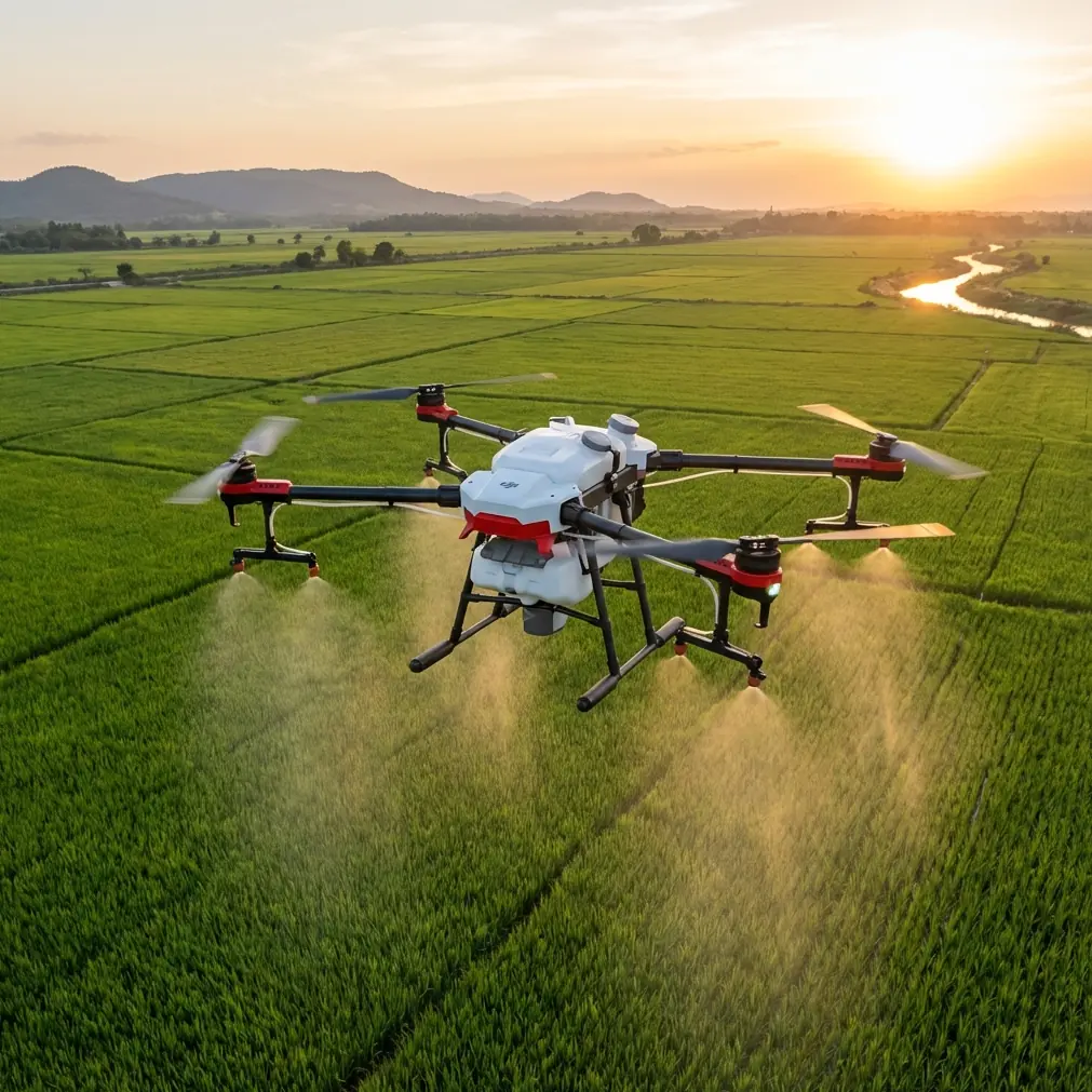
In coastal wildlife work, the T50 can be useful when the mission sits at the edge of agriculture and environmental stewardship: shoreline vegetation management, treatment of invasive growth near wetlands, precision application on buffer zones, and operational observation of land conditions that directly affect habitat quality. In those jobs, the aircraft’s raw carrying capability matters less than something more basic: whether the operator can keep a stable, disciplined mission profile in a place where wind, reflective water, soft ground, and sensitive animal activity punish sloppy decisions.
The most common mistake is not a lack of power. It is poor altitude judgment.
For coastal wildlife-adjacent operations, optimal flight altitude is never just about getting the job done faster. It determines spray drift risk, canopy penetration, swath consistency, image reliability if you are pairing flights with multispectral scouting, and how predictable the aircraft feels when marine wind starts moving across open ground. On the T50, altitude is the variable that quietly influences almost everything else.
Why coastal work changes the normal T50 playbook
A field inland can forgive a rough setup. Coastal terrain usually will not.
Open shorelines create unobstructed crosswinds. Salt moisture can affect visibility and residue buildup. Vegetation often transitions quickly from exposed flats to reed margins, embankments, and uneven access paths. Wildlife inspection adds another layer: your operating pattern should be deliberate and minimally disruptive, especially near nesting zones, marsh edges, and feeding corridors.
That is why the T50’s value here is tied less to headline specs and more to control quality. Centimeter precision from a strong RTK fix rate becomes operationally significant because your margin for error is smaller. A drifted line over a broad inland parcel might be an efficiency loss. A drifted line beside sensitive coastal habitat can become a stewardship problem.
This is also where nozzle calibration stops being routine maintenance and becomes mission protection. If your output is not behaving exactly as expected, altitude corrections alone will not save the pattern. A pilot who tries to solve every inconsistency by flying higher or lower is usually compensating for setup weaknesses that should have been handled before takeoff.
The right altitude is the one that preserves control, not the one that flatters productivity
People often ask for a single number. That is understandable, but coastal work resists one-size-fits-all answers.
Still, the principle is clear: with the Agras T50 in wildlife-sensitive coastal areas, the best altitude is typically the lowest stable altitude that maintains even coverage, protects the target zone, and keeps the aircraft out of unnecessary turbulence. Not the highest altitude that creates a wider swath width on paper.
That distinction matters.
A wider swath can look efficient in planning. In the field, extra height can increase spray drift, reduce deposition accuracy at the treatment zone, and make the aircraft more vulnerable to lateral movement from sea breeze. Once that happens, your application quality drops and your environmental risk goes up at the same time.
In practical terms, I advise operators to think in layers:
- Low enough for control: The aircraft should hold a predictable line without constant correction.
- High enough for obstacle and surface tolerance: Coastal edges are irregular, and reeds, berms, fencing, and uneven terrain can create deceptive sightlines.
- Tight enough for drift control: If wind is beginning to stretch droplets sideways, altitude is already part of the problem.
- Consistent enough for repeatability: If one pass is excellent and the next is unstable, the chosen altitude is not truly working.
The T50’s platform stability helps, but stability does not exempt the mission from physics. Salt-air wind gradients near open water can change quickly across a short distance. Operators who chase area throughput by climbing too high often lose the very precision that made the T50 worth deploying in the first place.
RTK discipline matters more near the coast than many crews expect
The LSI term “RTK Fix rate” gets tossed around as if it were a checkbox. In coastal wildlife work, it deserves more respect.
If you are trying to maintain centimeter precision along habitat boundaries, drainage lines, or treatment exclusion zones, a reliable RTK fix is not a luxury. It is part of your environmental control system. A weak or inconsistent fix can lead to subtle line deviations that are easy to miss during the mission and frustrating to explain afterward.
This becomes especially significant when flights support both treatment and inspection logic. If you are comparing visual findings, vegetation patterns, or multispectral outputs across time, positional consistency matters. The goal is not just to fly accurately once. The goal is to recreate the same spatial truth over multiple visits.
Near water, reflective surfaces and open geometry can sometimes tempt crews into overconfidence because the area looks visually simple. It is not simple. The environment has fewer obvious references, and that places even more value on GNSS confidence, verified route logic, and stable pre-flight checks.
Borrow a lesson from training culture, not just from agriculture
One of the most useful ideas in the reference material has nothing to do with crop spraying. It comes from training philosophy.
In the aerobatic training document, the emphasis is on establishing stable flight before executing the maneuver, then reflecting after the action rather than surviving it through “passive reaction.” That lesson translates surprisingly well to T50 operations in coastal environments.
E-31 stresses the importance of maintaining level flight before a roll. For T50 operators, the equivalent is this: do not enter a sensitive pass while already compensating for unstable speed, uncertain height, or poor alignment. If the aircraft is unsettled before the pass starts, the pass itself is already compromised.
E-34’s “post-action reflection” principle is just as relevant. Coastal work happens fast. Wind shifts, glare changes, and terrain cues come at you in sequence. Trying to mentally redesign the mission in the middle of every pass usually produces reactive flying. Better crews complete the line, note what happened, and adjust systematically. They do not improvise emotionally.
That is how operational maturity shows up with an Agras T50. Not in aggressive control inputs. In repeatable judgment.
The competition workflow lesson is more relevant than it looks
The educational drone competition document also contains a discipline that many commercial teams could use.
It specifies at least 5 minutes of free debugging time before formal activity, a 1-minute preparation stage, and a required final setup in the last 10 seconds before launch positioning. It also imposes penalties when the aircraft goes out of bounds for more than 5 seconds.
Those details come from a very different context, but the operational logic is excellent for wildlife-coastal T50 missions.
First, the minimum 5-minute debug mindset is a reminder that rushed setup creates expensive mistakes. On a coastal site, use that window to verify nozzle calibration, confirm RTK lock quality, inspect for residue or moisture issues, review exclusion zones, and make sure your route still reflects actual field conditions rather than yesterday’s assumptions.
Second, the “no program changes during the final preparation phase” idea has real value in commercial work. Once you enter your final launch sequence, last-second edits are often where preventable problems begin. Final prep should be for confirmation, not creative reconfiguration.
Third, the out-of-bounds rule is a sharp analogy for coastal habitat work. In competition, more than 5 seconds outside the allowed area wipes the score. In real operations, drifting into the wrong corridor may not trigger a scoreboard, but it can undermine habitat protection, treatment integrity, and operator credibility. Boundaries must be treated as operational facts, not suggestions.
Nozzle calibration and spray drift are linked to altitude more tightly than most crews admit
The T50 can deliver serious output, but volume does not equal precision unless the liquid system is behaving exactly as intended.
Nozzle calibration is where many coastal missions are quietly won or lost. If droplet behavior is not matching the intended application profile, the operator may misread the issue as an altitude problem, a wind problem, or a route spacing problem. Sometimes it is all three. But often calibration is the hidden trigger.
Here is the operational significance: coastal wind tends to expose inconsistency immediately. A nozzle setup that feels acceptable inland can become visibly uneven near shoreline airflow. Once that happens, climbing higher to smooth coverage usually worsens spray drift. Flying lower without checking output can produce over-application or poor distribution. Calibration is what allows altitude decisions to mean anything.
So if you are evaluating an Agras T50 for these missions, do not just ask how much area it can cover. Ask whether your process for calibration is disciplined enough to trust the aircraft in a sensitive boundary environment.
Multispectral support changes how you think about the T50 mission
The T50 is not a dedicated multispectral mapping platform, but coastal wildlife-related operations often benefit from multispectral context gathered through a broader drone workflow. That matters because treatment and inspection are increasingly connected.
If multispectral data identifies stress patterns in shoreline vegetation, standing water influence, or encroaching invasive zones, the T50 becomes the execution tool inside a larger decision chain. In that setup, altitude selection affects not only application quality but the credibility of your intervention against the mapped condition.
If the treatment swath does not align cleanly with the diagnosed zone, you lose the analytical value of the whole operation. That is another reason centimeter precision and route repeatability matter so much. The T50 should not be treated as a blunt-response aircraft in these environments. It should be integrated into a measured workflow.
Weather sealing matters, but it does not replace field discipline
An aircraft with strong environmental protection, including an IPX6K-grade build reference in the wider T50 conversation, is obviously attractive for coastal conditions. Moisture resistance and washdown practicality matter where salt and residue are part of the operating reality.
But ruggedization should not encourage bad habits.
The real win is not that the aircraft can tolerate a demanding environment. The real win is that the operator can maintain a clean, repeatable maintenance cycle despite that environment. Salt exposure, nozzle cleanliness, frame inspection, and connector checks all become more important near the coast, not less.
Durability buys margin. It does not buy negligence.
A better coastal workflow for the Agras T50
If I were building a field protocol for coastal wildlife-adjacent T50 work, I would keep it strict:
- Verify the mission boundary first. Sensitive habitat edges must be defined before productivity targets are discussed.
- Confirm RTK quality before route confidence. Good route geometry means little without dependable fix performance.
- Calibrate nozzles before debating altitude. Do not use flight profile changes to cover for liquid system inconsistency.
- Choose the lowest stable operational altitude that preserves coverage and drift control.
- Watch swath width skeptically. Bigger is not better if it weakens edge accuracy.
- Review each pass after completion, not mid-pass. This is the training principle that separates systematic improvement from reactive flying.
- Protect the final pre-launch phase from unnecessary changes. The competition workflow got this right.
If your team needs a second opinion on route logic, drift management, or setup choices for coastal habitat-adjacent work, this direct WhatsApp line is the simplest place to start: message Marcus Rodriguez here.
The real question is not whether the Agras T50 can fly the mission
It can.
The better question is whether your operation is disciplined enough to use the T50 without letting speed, capacity, or convenience degrade environmental control. Coastal wildlife work is where big-platform agricultural habits either mature or get exposed.
The operators who do well in this space are rarely the ones who chase the broadest swath width or the most aggressive work rate. They are the ones who respect boundary control, maintain a strong RTK fix rate, calibrate nozzles carefully, and choose an altitude that keeps the aircraft honest.
That is what makes the T50 effective here. Not hype. Judgment.
Ready for your own Agras T50? Contact our team for expert consultation.