Agras T50 for Mountain Wildlife Work: A Field Report
Agras T50 for Mountain Wildlife Work: A Field Report on Precision, Prep, and Thinking Ahead
META: A field-based expert article on using the DJI Agras T50 around mountain wildlife operations, with practical insight on pre-flight cleaning, precision planning, formation logic, and why proactive control matters in the field.
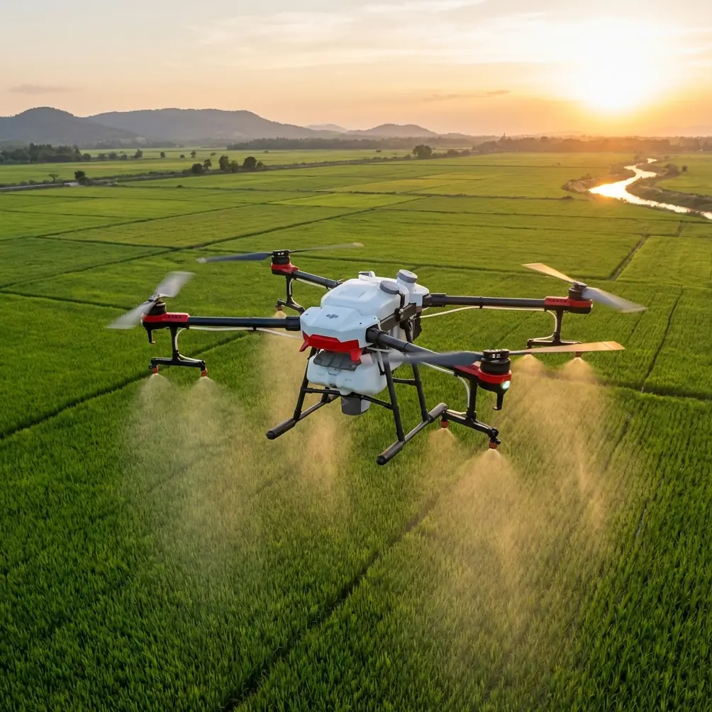
When people ask whether the Agras T50 belongs only in crop protection, they usually imagine flat fields, straight rows, and repetitive spray missions. Mountain wildlife work breaks that assumption quickly.
The T50 is not a wildlife drone in the traditional camera-first sense. It is a heavy-duty agricultural platform. Yet in rugged mountain environments, that platform logic—stability, route discipline, weather tolerance, payload architecture, and repeatable autonomous execution—can become surprisingly useful for civilian wildlife support tasks. I’m thinking here about habitat-edge inspection, water-source assessment, controlled nutrient or seed distribution in restoration zones, access-route checks for conservation teams, and terrain-following logistics planning around steep slopes. In those scenarios, the machine matters. But the method matters more.
What separates a clean mountain operation from a sloppy one is rarely raw airframe capability alone. It is preparation, command structure, and the operator’s ability to stay mentally ahead of the aircraft.
That principle appears in an older model-flight training text in a way that still feels painfully relevant. The document contrasts “passive reactors,” who chase the aircraft and correct late, with “active controllers,” who break the maneuver down in advance and issue the right command early. That distinction is not academic. In mountain wildlife work, where terrain compresses reaction time and airflow can shift hard along ridgelines, flying “behind the drone” is how operators create unnecessary adjustments, drift, and unstable mission quality. With the T50, especially when route repeatability and centimeter precision are expected, proactive control is the real safety feature.
Why the Agras T50 changes character in mountain use
In broadacre agriculture, operators often judge a platform by throughput. In wildlife inspection or habitat support, the priorities shift. Swath width still matters, but not as a bragging point. It matters because a wide working path can reduce repeated passes over a sensitive zone. RTK fix rate matters, not because it sounds technical, but because positional confidence is what allows a team to revisit the same corridor, spring line, or recovery plot with minimal disturbance. Nozzle calibration matters because any inconsistency in output near fragile vegetation or monitored animal pathways can turn a planned intervention into a contamination problem.
The T50’s appeal in these missions is that it can bring industrial discipline into places that are otherwise difficult to service consistently. That is especially valuable in mountain terrain, where access is often limited to narrow staging points and operations may need to be completed in short weather windows.
But the usual glossy discussion misses a practical truth: the hardest part of using a T50 in wildlife-adjacent mountain work is not launch. It is making sure the aircraft’s automation remains trustworthy after exposure to dust, pollen, mineral residue, moisture, and chemical carryover from prior jobs.
The pre-flight cleaning step too many teams treat as optional
If I had to name one habit that most improves field reliability, it would be pre-flight cleaning with intent.
Not cosmetic cleaning. Functional cleaning.
Before any mountain mission, especially one involving ecological inspection or low-volume targeted application, I want attention on the spray system, external sensing surfaces, and all interfaces that support accurate aircraft behavior. If the aircraft has been working previous agricultural blocks, residual buildup around nozzles can distort atomization and quietly worsen spray drift. A nozzle that is only slightly fouled may still pass a casual glance while producing uneven output. In mountain air, where lateral flow can change abruptly along a rock face or tree edge, that small inconsistency scales fast.
The same logic applies to calibration confidence. You cannot talk about nozzle calibration seriously if you start with contamination in the line or around the outlet. Calibration assumes a known baseline. Dirt, dried formulation, or moisture-film residue makes that assumption false.
This is where the T50’s field-worthiness and an IPX6K-style durability mindset become relevant. A robust exterior helps, but durability should not become an excuse for neglect. Water resistance is there to support work, not replace discipline. For wildlife-related missions, I advise crews to build a short cleaning-and-check sequence before every sortie:
- inspect and clear nozzle faces and surrounding housing
- verify there is no residue that could alter droplet pattern
- wipe positioning and sensing surfaces carefully
- confirm tank, lines, and fittings are free from prior-job contamination
- review intended swath width against actual terrain geometry, not just the previous mission template
This sounds basic. It is not. It is the difference between assuming precision and proving it.
Wildlife work rewards route logic, not improvisation
A surprising reference point for the T50 comes from a training document for educational drone formations. It describes how multi-drone programs can be loaded directly into the aircraft for execution without live tablet or computer control, and how the result can be previewed in advance. It also uses bird behavior to explain two forms of group movement: geese following a lead decision structure, and pigeons moving in a pattern that looks chaotic but remains collision-free and internally ordered.
That is a useful framework for mountain wildlife operations.
Most conservation teams imagine flight planning as either rigid or adaptive. In reality, good T50 work often combines both. The “geese” model is your preplanned route logic: one mission architecture, one primary decision path, repeatable and easy for the team to understand. The “pigeons” model is your local autonomy and obstacle handling: responsive, dynamic, and apparently messy to an observer, yet controlled underneath.
Why does that matter? Because mountains punish operators who confuse improvisation with flexibility. If you are inspecting a valley-side habitat band or distributing material along a restoration contour, you want the mission designed before takeoff, segmented in the mind, and reviewed as a sequence. Again, the old training text gets this right: the quickest learners imagine how each movement breaks down before the aircraft flies. That same cognitive habit is what makes T50 missions stable when GPS confidence fluctuates near terrain features, when wind curls over a ridge, or when line-of-sight becomes visually deceptive.
In other words, the T50 performs best in mountain wildlife scenarios when you stop thinking of it as a “big drone” and start treating it like a planned aerial process.
What an 8-minute city flight teaches us about remote mountain corridors
At first glance, an urban eVTOL passenger flight in Doha seems unrelated to a mountain wildlife field report. I think the opposite.
Recent reporting from Qatar described the EH216-S completing a city-center route between Doha Port and Katara Cultural Village in about 8 minutes, with an estimated time reduction of around 70% compared with similar ground travel. That flight also took place with civil aviation authorization and transport ministry support. The aircraft and mission profile are obviously different from an Agras T50. But the operational lesson is strikingly relevant: when air routes are planned well, aviation compresses terrain friction.
That is exactly why aircraft like the T50 deserve serious attention beyond standard farming narratives. In mountains, “distance” is rarely a straight-line problem. It is a terrain-access problem. Foot travel may be slow, vehicle approach may be impossible, and repeated climbs by field teams may create more disturbance than the aerial task itself. The Doha example demonstrates a larger truth about aerial systems: route design can convert a difficult ground path into a short, repeatable air corridor.
For wildlife teams, that means one should evaluate the T50 not only by output rates, but by corridor efficiency. Can it reach a remote edge zone without pushing people through nesting or grazing areas? Can it support a restoration pass that would otherwise require multiple risky ground traverses? Can it revisit the same target line with enough RTK consistency to keep intervention narrow and traceable?
Those are not abstract questions. They determine whether a drone operation reduces field pressure or simply relocates it.
Spray drift is the ecological line you cannot cross casually
In conventional crop work, spray drift is often framed as an efficiency loss or compliance issue. In wildlife landscapes, it is an ecological boundary issue. Drift can move material beyond the intended treatment strip and into watercourses, forage zones, pollinator patches, or unmanaged vegetation that researchers may be actively monitoring.
That makes swath width selection and nozzle calibration inseparable from mission ethics. Wider is not always better. Faster is not always cleaner. The T50 can cover ground efficiently, but mountain air does not behave like a uniform farm plain. Thermals, slope winds, and tree-driven turbulence can all alter deposition. Operators should adapt route timing, pass direction, and release parameters to terrain, then verify that the aircraft’s hardware condition supports the plan. A pre-flight cleaning step is therefore not a maintenance footnote; it is one of the first controls against drift uncertainty.
If your team is trying to standardize those setup checks for sensitive environments, this quick field contact can help coordinate a practical checklist: message a mountain-operations specialist.
Centimeter precision only matters if the mission design deserves it
The industry likes to repeat phrases such as centimeter precision, multispectral integration, and RTK accuracy. Those terms have value, but only when they solve a real field problem.
Take centimeter precision. In mountain wildlife support, it matters when you need repeatable placement along a narrow contour, a revegetation strip, or a monitored access line. It matters when returning to the same site over weeks and trying to separate ecological change from operational inconsistency. It matters when you are working near buffers where overshoot is unacceptable.
RTK fix rate also deserves a more mature discussion. A stable fix is not just about making maps look tidy. In terrain with elevation shifts, trees, and reflected signals, fix stability influences whether an autonomous aircraft behaves predictably across the mission. If fix confidence drops at the same places repeatedly, that becomes actionable knowledge. You redesign the route, adjust staging, alter segment lengths, or choose different operating windows.
Even multispectral workflows, while not the T50’s core identity in the way they are for dedicated mapping platforms, should be thought of through the same lens: not as feature collecting, but as decision support. If a conservation program is pairing aircraft tasks with vegetation stress analysis, then the role of the T50 is to execute the intervention side with enough consistency that the observation side remains meaningful.
A field method that fits the T50
If I were building a mountain wildlife operating protocol around an Agras T50, I would keep it simple and strict:
First, define the ecological objective narrowly. Inspection, micro-distribution, corridor support, or restoration assistance are not the same mission.
Second, break the route into segments before arrival on site. The old aerobatic training advice is still perfect here: think ahead of the aircraft, not behind it.
Third, perform deliberate pre-flight cleaning and verification, especially around nozzles and any surfaces that influence sensing or output consistency.
Fourth, set swath width and application logic for the terrain you actually have, not the easier terrain you wish you had.
Fifth, review RTK behavior and repeatability after the mission. Precision that cannot be repeated is only a lucky result.
That may sound conservative. Good. Mountain wildlife work should be.
Final assessment
The Agras T50 is most interesting in this context not because it can do everything, but because it brings structured aerial execution into places where ground operations are slow, disruptive, or inconsistent. The strongest ideas in the source material all point in the same direction. The Doha eVTOL flight showed how an air corridor can cut travel time dramatically—8 minutes, roughly 70% less than the comparable ground journey—and why route design changes what is operationally possible. The formation-training material showed that reliable flight is not random elegance; it is preplanned order, whether the pattern looks like disciplined geese or adaptive pigeons. And the flight-training text made the human factor explicit: progress comes when the operator commands proactively rather than reacting late.
That is exactly how the T50 should be used in mountain wildlife scenarios. Not as a blunt agricultural machine dropped into a delicate environment, but as a precision work platform whose success depends on clean hardware, disciplined planning, and operators who are always one step ahead of the aircraft.
Ready for your own Agras T50? Contact our team for expert consultation.