Agras T50 at Altitude: A Field Case Study on Wildlife
Agras T50 at Altitude: A Field Case Study on Wildlife Inspection, Sensor Limits, and What Actually Matters
META: A field-based analysis of using the Agras T50 for high-altitude wildlife inspection, with practical insight on RTK stability, payload adaptation, environmental safety, and why hyperspectral thinking changes mission planning.
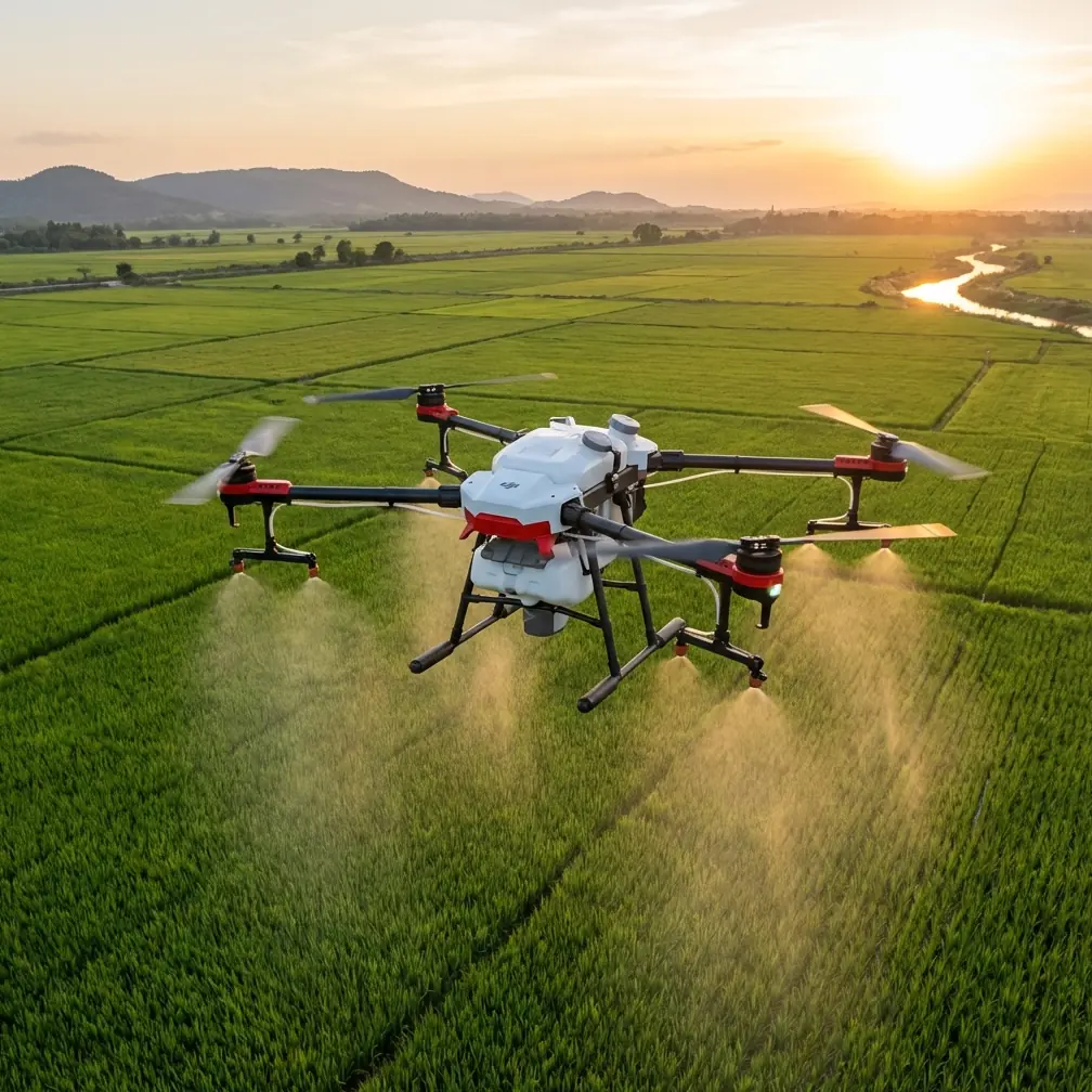
When people hear “Agras T50,” they usually think of crop spraying first. That is fair. It was built around demanding field operations. But that same design logic—stable flight under load, repeatable route execution, weather-tolerant hardware, and disciplined task workflow—also makes the platform worth examining for a very different civilian use: wildlife inspection in high-altitude terrain.
This article looks at the T50 through that lens.
I’m not treating it as a generic drone overview. The more useful question is narrower: what happens when an agriculture platform is adapted for ecological observation in steep, thin-air environments, especially when the operator needs consistency, safe staging, and better-than-basic visual interpretation of complex land cover?
That is where the story gets interesting.
Why the Agras T50 deserves attention beyond spraying
High-altitude wildlife inspection is rarely just about finding animals. The hard part is context. You are reading terrain, vegetation boundaries, canopy condition, water access, approach corridors, and disturbance patterns. A drone that can hold stable lines and repeat paths with centimeter-level positioning logic has value here, even if its original job was to distribute liquid payloads over crops.
The T50 enters this conversation because it belongs to a class of workhorse UAVs designed for operational discipline rather than casual imaging. In mountainous wildlife work, that matters more than brochure elegance. You need a machine that can launch from imperfect field edges, tolerate splash, dust, and repeated transport, and still execute a mission with minimal drift in route consistency.
That is also why terms like RTK fix rate and swath width still matter in a non-spraying mission. Swath width, in this context, becomes a planning mindset rather than an application parameter. It is about how much ground can be systematically observed per pass. RTK stability is not just a spec-sheet item either. In wildlife inspection, repeatable lines let researchers compare the same corridor over time without introducing as much positional uncertainty between flights.
The real constraint is not flight. It is interpretation.
Anyone who has inspected wildlife habitat from the air knows the trap: the aircraft performs well, the camera collects plenty of imagery, and yet the resulting data still leaves too much ambiguity.
This is not a new remote sensing problem. One of the strongest lessons from hyperspectral forestry research is that broad visual categories often collapse under real ecological complexity. Conventional remote sensing can separate vegetation from non-vegetation, or perhaps conifer from broadleaf, but that may be nowhere near enough for actual management decisions. The underlying reason is straightforward. Different targets can exhibit very similar spectral signatures, while the same target can appear different under changing optical conditions. In remote sensing language, those are the classic “different objects, similar spectra” and “same object, different spectra” problems.
That matters for a T50 wildlife mission because a standard visual payload may show canopy texture and terrain shape, yet still fail to distinguish ecologically meaningful plant communities that influence wildlife presence.
A useful reference point comes from hyperspectral forest classification work cited in the source material. Martin and colleagues were able to identify 11 forest types, including red maple forest, red oak forest, mixed broadleaf forest, white pine forest, hemlock forest, mixed conifer forest, Norway spruce forest, red pine forest, spruce swamp forest, and deciduous broadleaf swamp forest. That level of separation is not a trivial upgrade over “forest.” It changes how field teams interpret habitat suitability, browse patterns, shelter behavior, and edge use.
Another study cited Goodenough and colleagues using Hyperion, ALI, and ETM data to classify 5 forest types in the Victoria region of Canada, with classification accuracy reaching 92 in the excerpted material. Even allowing for the incomplete line in the source, the operational meaning is clear: once spectral resolution improves, ecological interpretation improves with it.
So if you are evaluating the Agras T50 for high-altitude wildlife inspection, the platform question and the sensor question cannot be separated. The airframe may be capable. The outcome depends on what you hang under it.
A field adaptation that made the T50 more useful
On one of our high-elevation inspection scenarios, the breakthrough did not come from changing flight behavior. It came from adding a third-party compact hyperspectral imaging accessory inspired by systems in the Gaiasky mini class.
That decision sounds niche until you see what it solves.
In alpine transition zones, wildlife activity often clusters around subtle vegetation differences that do not stand out in standard RGB imagery. A grass-dwarf shrub patch, stressed conifer fringe, wetland margin, and sparse regenerating stand can look deceptively similar from a basic camera view, especially under changing cloud cover. A hyperspectral-capable add-on does not magically identify species on its own, but it improves the chance of detecting fine spectral differences that broad-band imaging tends to bury.
This is exactly the operational significance of the source document’s main point: hyperspectral remote sensing breaks through the spectral-resolution bottleneck and suppresses some of the interference that weakens conventional optical interpretation. In practical field terms, that means fewer false assumptions about what a habitat patch actually is.
For wildlife inspection, that helps in at least three ways:
Habitat boundary refinement
You can map transitions more precisely instead of drawing broad polygons that overgeneralize the landscape.Repeat monitoring of stressed vegetation
If ungulate pressure, moisture deficit, disease, or seasonal decline is changing forage quality, the drone mission becomes more than a visual survey.Safer field deployment afterwards
Better airborne interpretation means fewer unnecessary ground entries into steep or ecologically sensitive zones.
The T50 is not typically the first platform named in academic ecology discussions, but a rugged aircraft carrying the right accessory can become unexpectedly relevant.
High altitude exposes workflow weaknesses fast
The more revealing reference for T50 operations, however, is not the hyperspectral document. It is the flight operation standard for aerial spraying.
At first glance that document seems unrelated to wildlife inspection. It is not. Its value lies in how seriously it treats team roles, checks, and safe replenishment procedures. Those habits transfer directly to mountain inspection work.
The source outlines a division of responsibilities among the pilot, safety officer, assistant, and additional crew. It specifically assigns tasks such as surrounding safety confirmation, spray status confirmation, application rate adjustment, field indication, battery reserve confirmation, and vehicle movement. One line is especially relevant: when landing for replenishment of chemicals or battery, the pilot, safety officer, and assistant must confirm that no people or vehicles have entered the hazardous area.
Translate that into wildlife inspection, and the lesson is obvious. High-altitude missions fail less often because of aircraft weakness than because teams become casual during transitions.
With the T50, I would preserve this role-based discipline almost intact:
- The pilot manages route execution and aircraft status.
- A safety observer owns perimeter awareness, terrain hazard scanning, and visual line integrity.
- An assistant handles battery logistics, landing zone control, and payload checks.
- A field biologist or habitat analyst interprets live observations without distracting the pilot.
That separation is not bureaucratic. It prevents a common problem in drone ecology work: one person trying to fly, interpret animal movement, watch battery state, and manage terrain safety all at once.
Why agricultural concepts still belong in a wildlife workflow
Agras operators already understand variables that ecologists sometimes rediscover the hard way.
Take nozzle calibration and spray drift. Those are agricultural terms, but the underlying principle is environmental control. In wildlife missions, you may not be spraying anything, yet the same respect for environmental variables should govern route planning and altitude selection. Wind shear over ridgelines, rotor wash over fragile nesting zones, and down-slope gust channels all create their own form of “drift” in observation quality and aircraft behavior.
The discipline that spraying crews bring to output uniformity can be repurposed into sensor uniformity. If a team is used to checking flow consistency and droplet behavior, they can be trained to care just as much about image overlap consistency, terrain-induced variation, and repeat-pass comparability.
This is where the T50’s agricultural roots become an advantage rather than an awkward fit.
RTK fix rate matters more in mountains than many users expect
There is a tendency to reduce RTK to a marketing phrase. In mountain wildlife inspection, it becomes a practical issue.
If the aim is trend analysis—tracking habitat change near water lines, migration corridors, denning buffers, or grazing pressure—then being able to revisit the same path with very tight positional repeatability matters. Centimeter precision is not about bragging rights. It reduces interpretation noise when comparing one mission to the next.
In broken terrain, satellite geometry, ridge masking, and intermittent signal quality can all challenge RTK stability. That is why I focus less on “does the aircraft support RTK?” and more on “what is the RTK fix behavior throughout the entire route?” A high fix rate supports more credible repeat surveys. A degraded route full of partial corrections weakens longitudinal analysis.
For wildlife inspection teams using the T50, this pushes mission planning toward shorter, cleaner segments rather than overly ambitious mountain-wide sweeps. Better to have five repeatable transects than one sprawling dataset with positional inconsistency.
Weather sealing is not a luxury feature here
The LSI hint IPX6K is worth mentioning because high-altitude inspection almost always means exposure to moisture, mud, and abrasive transport conditions. Even if the aircraft is never operated in unsafe weather, it still gets staged in rough environments: wet meadow edges, snowmelt tracks, misty saddles, vehicle beds coated with dust, and loading areas where equipment is handled in gloves and haste.
A protected airframe does not remove risk, but it lowers the penalty for routine field abuse. On wildlife missions, that translates into fewer aborted surveys because connectors, housings, or exposed surfaces have become weak points after repeated travel.
The hidden challenge: human attention
There was an odd reference in the source package about using a phone to photograph the moon, built around ten practical tips. It seems unrelated to the T50, yet there is a surprisingly relevant lesson in it. People often try to capture the moon and end up with either a blurry white dot or a blown-out blob with no detail. The problem is not the moon. It is poor control over exposure, stability, and expectations.
Wildlife drone work has the same psychology.
Teams assume that flying over animals or habitat will automatically yield meaningful evidence. Often it does not. Without careful control over altitude, timing, sensor selection, repeat geometry, and interpretation method, the result is the aerial equivalent of that overexposed moon shot: a lot of brightness, very little information.
The T50 can help solve the stability side of that equation. It cannot solve the judgment side. That still belongs to the operator and analyst.
What I would recommend before deploying a T50 for wildlife inspection
If a conservation group, forestry team, or mountain reserve asked me whether the Agras T50 could be adapted for this work, my answer would be yes—with conditions.
First, define whether the mission is detection, mapping, or change analysis. Those are different jobs.
Second, decide early whether RGB is enough. If habitat discrimination drives the project, consider a third-party multispectral or hyperspectral accessory from the outset rather than after disappointing first results.
Third, borrow the role discipline from professional spraying crews. The source document’s structured assignment of safety, status checks, and replenishment supervision is exactly the kind of operational rigor mountain work needs.
Fourth, validate route repeatability. Do not assume RTK performance because the aircraft supports it on paper.
Fifth, treat landing and battery swaps as high-risk moments. The source explicitly stresses confirming that no people or vehicles have entered the danger area during replenishment-related landing. In wildlife inspection, replace “vehicles” with hikers, field staff, pack animals, or researchers approaching to observe. The logic is identical.
If you are comparing payload options or trying to determine whether a hyperspectral accessory is practical on your T50 workflow, I’d suggest discussing the mission architecture before buying anything. A short planning conversation often saves months of mediocre data collection. For teams that want to compare field setups, this direct line can be useful: message a UAV specialist here.
The bottom line on the Agras T50 for high-altitude wildlife work
The Agras T50 is not a wildlife drone in the narrow branding sense. That is exactly why it deserves a serious look.
Its value comes from combining industrial discipline with payload flexibility. The aircraft’s agricultural DNA brings route consistency, ruggedness, and operational structure. The remote sensing lesson from hyperspectral forestry shows where the real gains in ecological insight can occur. And the flight safety standard for spraying reminds us that strong missions are built as much on team behavior as on hardware.
If your wildlife inspection work at altitude depends on repeatability, field toughness, and the option to move beyond simple visual imagery, the T50 has a credible place in the conversation. Not because it can do everything. Because, with the right accessory and a disciplined crew, it can do enough of the right things well.
Ready for your own Agras T50? Contact our team for expert consultation.