Agras T50 for Wildlife Inspection in Windy Conditions
Agras T50 for Wildlife Inspection in Windy Conditions: A Technical Review Grounded in Field Data
META: A technical review of the Agras T50 for wildlife inspection in windy conditions, with practical guidance on geotagged photo workflows, GPS point mapping, pre-flight cleaning, and precision field documentation.
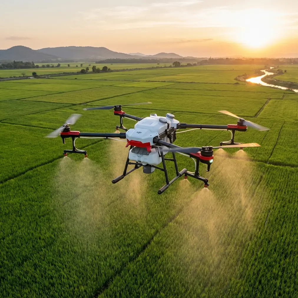
The DJI Agras T50 is usually discussed as an agricultural workhorse. That framing is too narrow. In the field, many operators are now evaluating whether a platform built for demanding farm environments can also support adjacent civilian missions, including wildlife inspection in exposed, windy terrain. That question deserves a serious answer, not a recycled brochure summary.
From an engineering perspective, the T50 becomes interesting for wildlife inspection not because it was designed as a camera drone first, but because it was built to stay useful when conditions are dirty, wet, and operationally messy. Wind magnifies every weakness in a drone workflow. Position holding gets harder. Visual interpretation gets less reliable. Small maintenance oversights become safety issues. Data quality drops fast if the aircraft, sensors, and field collection steps are not handled with discipline.
This is where a technical review has to move beyond headline specs and focus on mission logic.
Why a farm platform enters the wildlife inspection conversation
A wildlife inspection mission in windy conditions often looks deceptively simple on paper: fly out, observe animals or habitat features, geotag imagery, and bring the data back into a mapping environment. In reality, the hard part is not merely collecting images. It is producing location-linked evidence that remains useful after the flight.
That is why one of the most valuable reference points here is not a drone datasheet at all, but a documented ArcGIS workflow for lightweight UAV crop investigation. In that workflow, ArcMap’s “GeoTagged Photos To Points” tool reads the GPS data embedded in field photos, converts each image into a mapped point feature, and can store the original photo as an attachment in a File GDB database. That detail matters operationally. It means an inspection team can move from “we saw something during the flight” to “we have a geospatially traceable record tied to a specific point layer.”
For wildlife work, especially in wind-affected landscapes, that distinction is crucial. If a team is monitoring nesting zones, grazing pressure, water access points, vegetation damage, or animal movement indicators, the output must support later review. A photo without location context is weak evidence. A geotagged image attached to a mapped point is far more defensible.
The ArcGIS reference also includes another practical lesson: if output is sent to a Shape File instead of a geodatabase, the photo attachment option cannot be enabled. That may sound minor, but in real operations it changes the quality of the deliverable. If an Agras T50 mission is being used to inspect wildlife habitat edges or verify field observations under gusty conditions, preserving the actual image as an attached record inside the GIS database is often worth the extra care in setup.
Wind changes what “precision” really means
Many discussions around RTK fix rate and centimeter precision drift into abstraction. For wildlife inspection, precision has a direct operational meaning: can you return to the same feature, compare observations across dates, and trust that the image point corresponds to the ground reality you think it does?
In windy conditions, the answer depends on more than navigation hardware. It depends on the whole stack: platform stability, operator discipline, image timing, and whether the aircraft can maintain a clean enough geospatial trail while dealing with gusts. A high RTK fix rate matters because it reduces ambiguity when documenting a den entrance, a fence breach affecting animal movement, or a patch of damaged vegetation near a waterline. “Centimeter precision” is not a marketing phrase in that context; it is what allows repeated inspection without turning every revisit into guesswork.
For a T50 operator, that means the mission design should be conservative. Swath width may be a key agricultural planning term, but for wildlife inspection it becomes a reminder not to overextend coverage just because the aircraft can work big areas. In wind, narrower passes and more intentional overlap usually produce cleaner records than trying to maximize area in one sortie.
The image interpretation problem most teams underestimate
Another useful detail from the ArcGIS source is its blunt observation that even after zooming in on orthomosaic imagery, you may still be unable to identify a crop by looking clearly at the leaves alone. The document’s point was agricultural interpretation. The broader lesson applies directly to wildlife inspection: overhead imagery has limits.
That matters for anyone considering the Agras T50 for habitat or animal-related surveys. In windy conditions, vegetation movement, oblique angles, and variable light can make aerial imagery less conclusive than expected. You may identify tracks, disturbance patterns, feeding zones, or habitat boundaries, but species-level interpretation often requires ground-truthing or low-altitude sample imagery. If a team assumes the drone will replace all close verification, the dataset will disappoint them.
This is where multispectral discussions should be treated carefully. Multispectral tools can add value in vegetation stress analysis or habitat condition monitoring, but they do not magically resolve every interpretation problem. If your mission is to inspect wildlife-related landscape indicators rather than simply map acreage, image context still matters more than sensor hype.
Pre-flight cleaning is not housekeeping; it is risk control
The narrative spark for this review is a simple one: a pre-flight cleaning step. On a hard-use platform like the T50, this is not optional, especially in a windy field environment.
Dust, dried spray residue, plant matter, mud splash, and salt-laden moisture all accumulate in ways that can interfere with safety systems and data collection quality. Before any wildlife inspection flight, the operator should perform a cleaning routine focused on exposed surfaces, sensor windows, landing gear contact areas, arm joints, payload interfaces, and any camera or auxiliary optical surfaces used for documentation. If the aircraft has been used in agricultural operations, nozzle areas and fluid-contact zones deserve special attention even when the next mission is non-spraying. Residue migration is real. It can reach areas you do not initially suspect.
This is where terms like IPX6K are often misunderstood. A rugged protection rating helps the aircraft tolerate harsh cleaning and field contamination, but it does not eliminate the need to clean. In fact, ruggedized equipment often stays in service longer precisely because operators assume it can handle abuse. That is backwards. If you want consistent RTK performance, clean sensor visibility, and reliable obstacle or positioning support in wind, start with a clean airframe.
For teams crossing between agriculture and conservation support roles, this step also has biosecurity value. A poorly cleaned aircraft can carry seeds, mud, and organic debris from one area to another. In sensitive wildlife zones, that is more than a cosmetic issue.
What an Agras T50 workflow should look like for wildlife inspection
A credible T50 wildlife inspection workflow in windy conditions should be built around verification, not speed.
First, define the inspection objective narrowly. Are you checking habitat disturbance, perimeter integrity, water access, animal congregation indicators, or vegetation condition? “Inspect wildlife” is too broad to produce useful data.
Second, decide what evidence format the mission must generate. If the output needs to stand up to later analysis, use a workflow modeled on the ArcGIS process described in the reference: collect geotagged photos, convert them to point features, and store the images as attachments in a File GDB. That way each visual observation has a map location and a retrievable original image.
Third, account for wind in route design. Do not treat full swath width as an achievement metric. In many inspection scenarios, smaller sectors flown more deliberately produce a better result than broad coverage with weak interpretability.
Fourth, build a cleaning and calibration checkpoint into launch preparation. If the T50 is operating near agricultural contexts, this is also the moment to verify that any spray-related hardware is not carrying contamination forward. Even if no liquid application is planned, experienced operators know that nozzle calibration discussions are really part of a broader maintenance culture: if a team is sloppy with liquid system upkeep, it is often sloppy with the rest of the aircraft as well. That attitude shows up in field reliability.
Fifth, validate image usefulness before leaving the site. The ArcGIS source highlights the value of clicking a mapped plot point and opening the high-resolution original image. That same principle should be used in wildlife inspection. A quick in-field spot check can reveal whether motion blur, poor framing, or inadequate altitude made the imagery less useful than expected.
Lessons from outside agriculture that still matter
One surprising reference in the source material comes from outside the farm and GIS context entirely: a 2016 agreement in which Lung Biotechnology purchased 1,000 drones for rapid artificial organ transport. Whatever one thinks of that historical project, one fact is operationally relevant here: specialized drone deployment becomes viable when the mission depends on fast, traceable, repeated transport or documentation under time pressure.
Why mention that in an Agras T50 review about wildlife inspection? Because it illustrates a larger point. Industrial drone adoption has repeatedly expanded by repurposing robust platforms into adjacent roles. The T50 should be assessed in that same spirit. Not every mission needs a lightweight cinema-style airframe. Sometimes the better tool is the aircraft designed to survive repetitive outdoor work, maintain disciplined route execution, and support structured field operations.
The significance is not that a wildlife team needs 1,000 aircraft. It is that drone value emerges when the workflow around the platform is mature. Data capture, geolocation, maintenance discipline, and post-processing matter more than category labels.
Where the T50 fits — and where it does not
The Agras T50 can make sense for wildlife inspection in windy environments when the task overlaps with large-area habitat review, perimeter monitoring, field-edge observation, or repeated evidence collection in rough outdoor conditions. Its appeal lies less in cinematic finesse and more in operational resilience.
It is less compelling if the mission depends on highly discreet close-proximity observation, minimal downwash near sensitive animals, or specialized ecological imaging that requires a very different payload architecture. A heavy-duty agricultural airframe should not be forced into every conservation workflow just because it is available.
That distinction matters. Good drone programs are built on fit, not enthusiasm.
The real benchmark: can the dataset survive scrutiny?
That is the standard I would use when assessing the Agras T50 for wildlife inspection in wind. Not whether the aircraft can fly. It can. Not whether it is rugged. It is. The real question is whether the mission produces evidence that remains useful after the field team goes home.
The strongest clue from the reference material is the ArcGIS geotagged-photo workflow. Batch-reading GPS data from images, writing those records into a point layer, and attaching the original photos in a geodatabase is exactly the kind of method that turns drone flights into operational intelligence. Add disciplined pre-flight cleaning, careful route planning in gusts, and repeatable geospatial control, and the T50 becomes far more than a crop platform.
If you are planning a field program and want to compare workflow options around the Agras T50, you can message a technical specialist here to discuss mission design, data structure, and maintenance considerations before deployment.
The aircraft is only one part of the answer. The rest is process. In windy wildlife inspection, process is what separates a flight from a result.
Ready for your own Agras T50? Contact our team for expert consultation.