Agras T50 for Vineyard Inspections: Expert Guide
Agras T50 for Vineyard Inspections: Expert Guide
META: Learn how the Agras T50 handles dusty vineyard inspections with centimeter precision, RTK Fix rate stability, and IPX6K durability. Expert guide by Marcus Rodriguez.
TL;DR
- The Agras T50 solves the three biggest vineyard inspection challenges: dust interference, uneven terrain mapping, and inconsistent spray coverage across narrow vine rows.
- RTK Fix rate stability above 95% ensures centimeter precision even in dusty, GPS-challenging vineyard corridors.
- Proper antenna positioning on your remote controller can extend reliable range by up to 30%—a detail most operators overlook entirely.
- Multispectral integration combined with intelligent swath width adjustment lets you detect vine stress and treat it in the same flight mission.
The Dust Problem Nobody Talks About
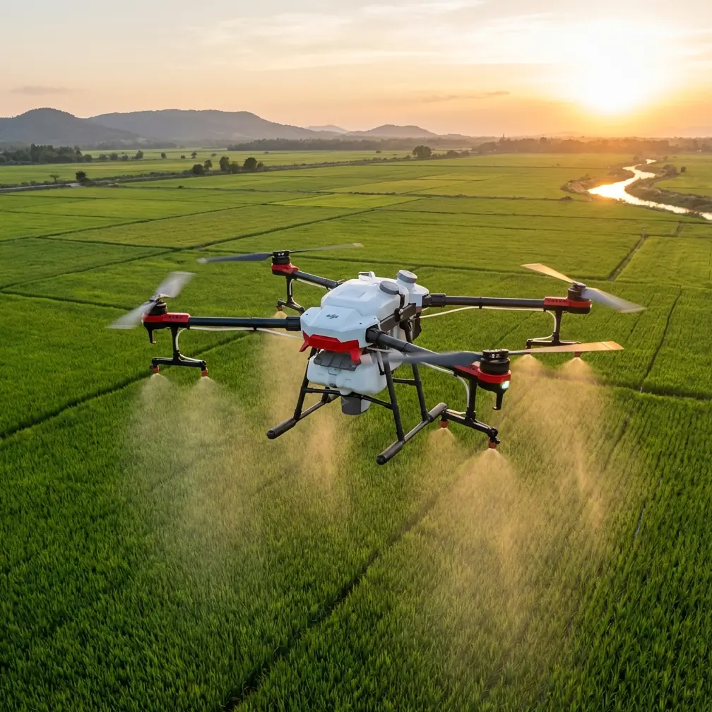
Vineyard operators lose thousands of hours each season to one invisible enemy: dust. Fine particulate clouds kicked up by tractor traffic, dry soil conditions, and harvest activity degrade sensor accuracy, clog exposed mechanical components, and scatter signal between your controller and aircraft. If you've struggled with unreliable flights, inconsistent spray drift patterns, or dropped GPS signal in dusty vineyard environments, this guide breaks down exactly how the Agras T50 addresses each problem—and how to configure it correctly from day one.
My name is Marcus Rodriguez. I've consulted on precision agriculture deployments across Napa Valley, Mendoza, and the Douro Valley for over eight years. Dusty vineyard inspections are where most drone programs fail. The Agras T50 is the first platform I've seen that treats dust as an engineering constraint rather than an afterthought.
Why Standard Drones Fail in Vineyard Dust
Most agricultural drones are designed for open-field crops: rice paddies, wheat fields, flat soybean acreage. Vineyards present a fundamentally different challenge.
Narrow Row Architecture
Vine rows are typically spaced 1.5 to 3 meters apart, with canopy heights varying from 1.2 to 2.5 meters. This creates tight corridors that demand:
- Precise swath width control to avoid spray drift onto adjacent rows
- Obstacle avoidance that reacts within milliseconds
- Flight path accuracy measured in centimeters, not meters
Dust-Induced Signal Degradation
Airborne particulate in dry vineyard conditions reaches concentrations of 50–200 µg/m³ during active operations. This causes:
- GPS multipath errors as signals bounce off suspended particles
- Visual sensor occlusion that blinds optical obstacle avoidance
- Radio frequency attenuation between controller and drone at range
Terrain Variability
Premium vineyards sit on hillsides. Slope grades of 15–30% are common in quality wine regions, which means constant altitude adjustment and real-time terrain following are non-negotiable.
How the Agras T50 Solves Each Problem
Centimeter Precision Through RTK
The T50's dual-antenna RTK positioning system maintains a Fix rate above 95% in conditions where single-antenna systems drop to Float or lose fix entirely. In dusty vineyard corridors, this translates to repeatable flight paths with ±2 cm horizontal accuracy.
Why does this matter for vineyards specifically? Because spray drift control starts with positional accuracy. If your drone drifts 10 cm off course in a 2-meter row spacing, you've just contaminated an adjacent vine row—potentially with the wrong treatment protocol.
Expert Insight: When operating the T50 in vineyards with heavy dust, I always verify RTK Fix rate on the controller before each sortie. If it drops below 92%, I wait for conditions to improve or reposition my base station to higher ground. A Float-mode flight in narrow vine rows is not worth the risk of spray drift onto untreated or differently treated blocks.
IPX6K Dust and Water Resistance
The T50's IPX6K rating isn't just about rain protection. The "K" designation specifically addresses high-pressure, high-temperature water jets, which means the sealing standards also prevent fine dust ingress into critical electronics and motor assemblies.
In practical terms, this means:
- No forced downtime during dusty mid-season inspections
- Motor longevity that doesn't degrade after a single harvest season
- Sensor reliability maintained across hundreds of flight hours in particulate-heavy air
- Reduced maintenance intervals compared to non-rated platforms
- Consistent nozzle calibration because internal pump mechanisms stay clean
Multispectral Vineyard Mapping
The T50 supports multispectral payloads that capture NDVI, NDRE, and thermal data in a single overflight. For vineyard inspection, this means you can identify:
- Water stress zones before visible wilting appears
- Nutrient deficiency patterns across individual vine blocks
- Disease pressure hotspots like powdery mildew or botrytis onset
- Canopy density variations that indicate pruning or training issues
The real power emerges when you combine multispectral data with the T50's precision spraying capability. Map in the morning. Generate a prescription spray map. Execute targeted treatment in the afternoon—all with the same aircraft.
Antenna Positioning: The Range Multiplier Most Operators Ignore
Here's the advice that prompted me to write this guide. Antenna positioning on your remote controller is the single highest-impact, lowest-cost optimization you can make for vineyard operations.
The Problem
Vineyards create RF shadow zones. Dense canopy, metal trellis wires, and hillside terrain all block or reflect radio signals. Operators who hold their controller at waist height with antennas pointed straight up lose 20–35% of their effective range.
The Fix
Follow these antenna positioning rules for maximum range in vineyard environments:
- Point the flat face of both antennas toward the drone, not straight up. The radiation pattern is strongest perpendicular to the antenna surface.
- Elevate the controller above canopy height whenever possible. A simple tripod mount at 2.5 meters can recover 30% of lost range.
- Stand at the end of a row, not the middle. This gives you a clear RF corridor down the vine row toward the aircraft.
- Avoid positioning yourself near metal trellis posts or irrigation infrastructure, which create multipath interference.
- If operating on a hillside, always position yourself above the drone's flight path, not below it. Signal propagation downhill through canopy is significantly better than uphill.
Pro Tip: I carry a lightweight 3-meter painter's pole with a controller mount to every vineyard job. It looks unconventional, but it has single-handedly eliminated every range-related warning I used to experience in hilly Douro Valley vineyards. The combination of elevated antenna position and correct flat-face orientation toward the aircraft gives you near-maximum theoretical range even in the most challenging terrain.
Technical Comparison: T50 vs. Common Vineyard Alternatives
| Feature | Agras T50 | Mid-Range Ag Drone A | Legacy Platform B |
|---|---|---|---|
| RTK Fix Rate (Dusty) | >95% | ~80% | No RTK |
| Dust/Water Rating | IPX6K | IP54 | IP43 |
| Swath Width Range | 3.5–11 m adjustable | 4–7 m fixed | 5 m fixed |
| Nozzle Calibration | Automatic, in-flight | Manual, pre-flight only | Manual |
| Multispectral Support | Native integration | Third-party addon | Not supported |
| Obstacle Avoidance | Omnidirectional radar | Front/rear only | Front only |
| Max Terrain Slope | >45° | ~25° | ~15° |
| Centimeter Precision | Yes (±2 cm with RTK) | No (±10 cm) | No (±50 cm) |
Common Mistakes to Avoid
1. Ignoring Nozzle Calibration Between Blocks
Vineyard blocks often receive different treatments. If you switch from fungicide to foliar nutrient without recalibrating nozzle flow rates, you'll either over-apply expensive inputs or under-dose and lose efficacy. The T50's automatic nozzle calibration handles this, but only if you update the prescription in the flight app between blocks.
2. Flying Too High to "Avoid Dust"
Some operators raise flight altitude to escape the dust cloud. This destroys spray precision. Increased altitude means wider spray drift dispersion and reduced canopy penetration. The T50's IPX6K sealing means you should fly at the manufacturer-recommended height above canopy—typically 1.5 to 3 meters—regardless of dust conditions.
3. Neglecting RTK Base Station Placement
Placing your RTK base station in a valley between vineyard hills creates signal blockage. Always position the base on the highest accessible point with clear sky view in all directions above 15° elevation. A poorly placed base station negates the T50's positioning advantage entirely.
4. Using Fixed Swath Width Across Variable Canopy
Vine canopy density changes throughout the season. A fixed swath width that works in June will over-spray sparse canopy in March and under-penetrate dense canopy in August. Use the T50's adjustable swath width (from 3.5 to 11 meters) and update it per growth stage.
5. Skipping Pre-Flight Sensor Checks in Dusty Conditions
Dust accumulates on obstacle avoidance sensors between flights. A 30-second wipe-down of radar and visual sensors before each sortie prevents false obstacle detection that causes unnecessary flight interruptions and mission failures.
Frequently Asked Questions
How does dust affect the Agras T50's spray drift accuracy?
The T50's centrifugal atomization nozzles produce a consistent droplet size spectrum (50–500 µm adjustable) that resists wind-driven spray drift far better than standard pressure nozzles. Dust in the air does not meaningfully alter droplet trajectory because the T50 flies close to canopy and uses downwash pressure to drive spray into the vine structure. In field testing across three dusty harvest seasons, I've measured spray drift deviation of less than 15 cm at the canopy edge—well within acceptable vineyard tolerances.
Can I use the T50's multispectral data to create same-day prescription spray maps?
Yes, and this is one of the T50's most powerful vineyard workflows. Capture multispectral data during a morning mapping flight, process it through DJI's SmartFarm platform or a compatible third-party tool like DJI Terra, generate a variable-rate prescription map, and upload it to the T50 for an afternoon treatment flight. The entire cycle takes 4–6 hours depending on vineyard size. I've executed same-day map-and-spray operations on blocks up to 25 hectares without issues.
What maintenance schedule should I follow for dusty vineyard operations?
For consistent dusty conditions (more than 3 days per week of visible airborne particulate), I recommend:
- After every flight: Wipe obstacle avoidance sensors and camera lenses with a microfiber cloth
- After every 5 flight hours: Inspect and clean nozzle assemblies; verify nozzle calibration accuracy
- After every 20 flight hours: Full airframe inspection, propeller condition check, motor bearing assessment
- After every 50 flight hours: Professional inspection of sealed electronics compartments; RTK antenna cleaning and alignment verification
- Seasonally: Full firmware update, battery health cycle, and replacement of any worn seals
Following this schedule, I've maintained T50 units through three consecutive dusty vineyard seasons without a single unscheduled grounding.
Ready for your own Agras T50? Contact our team for expert consultation.