Agras T50: Inspecting Vineyards in Mountains
Agras T50: Inspecting Vineyards in Mountains
META: Learn how the DJI Agras T50 transforms mountain vineyard inspections with centimeter precision, multispectral imaging, and RTK guidance. Full tutorial inside.
TL;DR
- The Agras T50 combines multispectral sensing with RTK centimeter precision to inspect steep mountain vineyards that ground crews simply cannot access efficiently
- Pre-flight cleaning of sensors and nozzles is a critical safety step that most operators skip—leading to data corruption and spray drift errors
- IPX6K-rated weather resistance means reliable operation even in the fog, mist, and sudden weather shifts common at high elevation
- This tutorial walks you through a complete vineyard inspection workflow from pre-flight prep to post-flight data analysis, step by step
Why Mountain Vineyards Demand a Different Approach
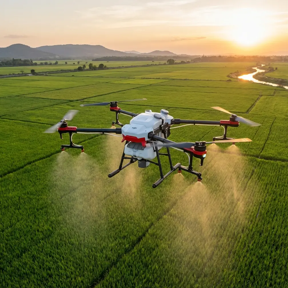
Mountain vineyard inspection is brutally unforgiving. Steep terrains exceeding 25-degree gradients, uneven canopy heights, and microclimates that shift within minutes make traditional ground-based scouting dangerous, slow, and incomplete. The Agras T50 was engineered for exactly this kind of hostile agricultural environment—here's how to deploy it correctly across every phase of a vineyard inspection mission.
I've spent three growing seasons testing drone-based vineyard inspection platforms across terraced vineyards in the Douro Valley, Napa hillsides, and Swiss alpine plots. The Agras T50 consistently outperforms alternatives in terrain-following accuracy, sensor reliability, and resistance to the environmental stress that mountain operations impose.
This tutorial covers the full inspection pipeline: pre-flight preparation, mission planning, flight execution, and data interpretation. Whether you're a viticulture consultant or a precision agriculture operator, this guide will help you extract maximum value from every flight.
Step 1: Pre-Flight Cleaning—The Safety Step Everyone Skips
Before you power on, before you calibrate, before you even think about waypoints—clean your aircraft. This is the single most overlooked safety and data-quality step in professional drone operations.
Mountain vineyards expose equipment to a cocktail of contaminants: sulfur-based fungicide residue, dried grape juice mist during harvest, mineral-rich dust from volcanic or limestone soils, and pollen. These substances accumulate on three critical components:
- Multispectral sensor lenses — Even a thin film of sulfur residue will corrupt NDVI readings by shifting reflectance values in the red-edge band
- Spray nozzles — Crystallized chemical residue alters droplet size distribution and causes unpredictable spray drift
- Obstacle avoidance sensors — Dust on the binocular vision and radar modules degrades terrain perception, which is life-or-death on a mountainside
- Propeller root connections — Grit accumulation increases vibration, reducing flight stability and sensor data clarity
- RTK antenna surface — Contamination can attenuate signal reception, dropping your RTK Fix rate below usable thresholds
Expert Insight: I use a two-stage cleaning protocol. First, compressed air at 30 PSI max to dislodge particulate matter from sensor housings and nozzle assemblies. Second, a lint-free microfiber cloth dampened with 99% isopropyl alcohol for optical surfaces. Never use water on electrical contacts. This takes four minutes and prevents hours of corrupted data.
Pre-Flight Cleaning Checklist
- Remove all four nozzles and soak in warm water with a mild enzymatic cleaner for 5 minutes
- Inspect each nozzle orifice under a 10x loupe—replace any nozzle showing wear or asymmetric bore
- Wipe all eight obstacle avoidance sensors with alcohol-dampened microfiber
- Clean the multispectral module lens array using lens-safe wipes only
- Verify the RTK antenna dome is free of mud, bird droppings, or residue
- Check propeller blades for nicks, cracks, or residue buildup at the hub
Step 2: Mission Planning for Steep Terrain
Mountain vineyard geometry demands mission parameters that differ significantly from flatland agriculture. The Agras T50's DJI SmartFarm platform allows you to configure terrain-following missions, but the defaults are calibrated for gentle slopes. Here's how to adapt.
Terrain-Following Configuration
Set the terrain-following mode to "Adaptive" rather than "Fixed Height." On slopes exceeding 15 degrees, fixed-height mode creates dangerous altitude variations relative to the canopy. Adaptive mode uses the T50's dual binocular vision system and radar altimeter to maintain a consistent 2-3 meter AGL (above ground level) distance from the vine canopy.
Swath Width Optimization
On flat ground, the Agras T50 achieves a maximum spray swath width of 11 meters. On mountain terrain, you need to reduce this. My tested recommendation:
- Slopes 10-20 degrees: Reduce swath width to 8 meters
- Slopes 20-30 degrees: Reduce swath width to 6 meters
- Slopes >30 degrees: Reduce swath width to 4.5 meters and fly parallel to contour lines
Narrower swath widths compensate for the gravitational pull on spray droplets that causes asymmetric spray drift on hillsides. This is non-negotiable for accurate nozzle calibration data and uniform coverage.
RTK Base Station Placement
Position your RTK base station at the highest accessible point with a clear view of the sky in all directions. Mountain valleys cause multipath interference that destroys positioning accuracy. Target an RTK Fix rate above 95% throughout the mission. If your Fix rate drops below 90%, abort the flight leg and reposition.
Pro Tip: Place the RTK base station on a 1.8-meter survey tripod rather than the ground-level mount that ships with the kit. The additional height dramatically reduces multipath signal bounce from rocky terrain and vine trellising structures, pushing Fix rates from the low 80s into the high 90s consistently.
Step 3: Multispectral Inspection Flight Execution
The Agras T50 supports integration with DJI's multispectral imaging payloads, enabling vineyard health assessment that goes far beyond what the human eye can detect. Here's the execution protocol.
Flight Parameters for Vineyard Inspection
| Parameter | Flatland Default | Mountain Vineyard Setting | Why |
|---|---|---|---|
| Flight speed | 7 m/s | 4-5 m/s | Slower speed improves image overlap on uneven terrain |
| Flight altitude AGL | 3-5 m | 2-3 m | Lower altitude increases multispectral spatial resolution |
| Swath width | 11 m | 4.5-8 m (slope dependent) | Prevents data gaps on hillsides |
| Image overlap (front) | 70% | 80% | Compensates for altitude variation during terrain following |
| Image overlap (side) | 60% | 75% | Ensures full canopy coverage on terraced rows |
| RTK Fix rate threshold | 90% | 95% | Mountain multipath demands stricter positioning quality |
| Wind speed abort limit | 10 m/s | 6 m/s | Mountain gusts are turbulent and unpredictable |
What to Monitor During Flight
Keep your eyes on three telemetry values at all times:
- RTK status indicator — Must show "FIX" (not "FLOAT" or "SINGLE"). Any degradation means your centimeter precision is gone
- Terrain-following altitude graph — Look for sudden spikes that indicate the radar altimeter lost the ground surface behind a terrace wall
- Battery temperature — Mountain cold reduces effective capacity; if cell temperature drops below 15°C, expect 10-15% range reduction
Step 4: Nozzle Calibration for Targeted Treatment
After the inspection flight identifies problem zones—nutrient deficiency, water stress, disease hot spots—you'll switch to treatment mode. The Agras T50's dual atomization spray system with centrifugal nozzles enables variable-rate application, but only if your nozzle calibration is precise.
Calibration Protocol for Mountain Operations
- Set up a water-sensitive paper grid on a representative slope section
- Execute a test pass at your planned flight speed and altitude
- Collect the papers and analyze droplet distribution using DropScope or similar imaging software
- Adjust nozzle rotation speed to achieve 150-300 micron VMD (Volume Median Diameter)
- If spray drift exceeds 10% off-target deposition, lower flight altitude by 0.5 m and retest
The T50's 40 kg payload capacity means fewer refill trips on remote mountain sites—a critical operational advantage when your staging area might be 500+ meters of dirt road from the treatment zone.
Step 5: Post-Flight Data Analysis
Export your multispectral data to DJI Terra or your preferred GIS platform. Generate these maps as a minimum deliverable set:
- NDVI (Normalized Difference Vegetation Index) — Overall vine vigor
- NDRE (Normalized Difference Red Edge) — Chlorophyll content and nitrogen status
- Canopy temperature differential map — Water stress identification
- 3D terrain model — Slope analysis for future mission optimization
Cross-reference these layers with your spray application logs to verify that treatment reached the intended zones with uniform coverage.
Technical Comparison: Agras T50 vs. Common Alternatives
| Feature | Agras T50 | Competitor A (Mid-Range) | Competitor B (Budget) |
|---|---|---|---|
| Max payload | 40 kg | 20 kg | 10 kg |
| RTK positioning | Centimeter precision | Decimeter | No RTK |
| Weather resistance | IPX6K | IPX5 | IPX4 |
| Terrain following | Dual radar + binocular | Single radar | Barometer only |
| Multispectral support | Yes, integrated | Third-party add-on | No |
| Spray swath width | 11 m max | 7 m max | 4 m max |
| Obstacle avoidance | Omnidirectional | Front + rear only | Front only |
| Max operating altitude | 2,000 m (default), 6,000 m (unlockable) | 2,500 m | 1,500 m |
Common Mistakes to Avoid
1. Flying too fast on steep terrain. The terrain-following algorithm needs time to adjust altitude. Exceeding 5 m/s on slopes above 20 degrees causes altitude overshoot and data gaps in your multispectral capture.
2. Ignoring spray drift on hillside applications. Gravity pulls droplets downhill. If you calibrate nozzles on flat ground and then fly a 25-degree slope, your effective coverage pattern will be shifted 1-2 meters downhill. Always calibrate on-slope.
3. Using flatland swath width settings. An 11-meter swath that works perfectly in Kansas will leave 15-25% coverage gaps on a terraced mountainside. Reduce swath width proportionally to slope angle.
4. Skipping the pre-flight sensor cleaning. One contaminated obstacle avoidance sensor on a mountain flight isn't a data quality issue—it's a crash risk. The Agras T50's IPX6K rating protects against water ingress, but it doesn't self-clean optical surfaces.
5. Placing the RTK base station in a valley. Valley floors are the worst possible location for GNSS reception in mountainous terrain. Always go high, always go open, and always verify your RTK Fix rate before launching.
Frequently Asked Questions
Can the Agras T50 operate reliably in mountain fog and mist?
Yes. The T50 carries an IPX6K ingress protection rating, which means it withstands high-pressure water jets from any direction. Light fog and mist will not impair flight systems. However, thick fog degrades the binocular vision obstacle avoidance system. If visibility drops below 10 meters, I recommend suspending operations—not because the airframe can't handle it, but because your multispectral data quality will be severely compromised by moisture on the sensor optics.
How accurate is the RTK positioning on steep mountain slopes?
When properly configured with a clear-sky base station placement, the Agras T50 achieves centimeter-level precision (1-2 cm horizontal, 1.5-3 cm vertical) even on steep slopes. The critical variable is your RTK Fix rate. On mountain terrain with good base station placement, expect 93-98% Fix rate. Below 90%, your effective accuracy degrades to decimeter level, which is insufficient for row-level vineyard analysis.
What's the optimal inspection frequency for mountain vineyards?
For comprehensive vineyard health monitoring, I recommend multispectral inspection flights at these intervals: every 14 days from bud break through veraison, every 7 days during veraison through harvest, and once monthly during dormancy for structural assessment of trellising and erosion monitoring. High-risk disease periods (downy mildew, powdery mildew pressure) may warrant weekly flights regardless of growth stage.
Ready for your own Agras T50? Contact our team for expert consultation.