Vineyard Inspection Guide: Agras T50 Best Practices
Vineyard Inspection Guide: Agras T50 Best Practices
META: Master vineyard inspections with the Agras T50 drone. Learn expert calibration, spray techniques, and urban flight protocols for precision viticulture results.
TL;DR
- RTK positioning delivers centimeter precision for row-by-row vineyard mapping and targeted spray applications
- IPX6K rating ensures reliable operation during early morning inspections when dew and light rain are common
- Multispectral integration identifies vine stress patterns invisible to standard RGB cameras
- Swath width optimization reduces spray drift by up to 68% in urban-adjacent vineyard environments
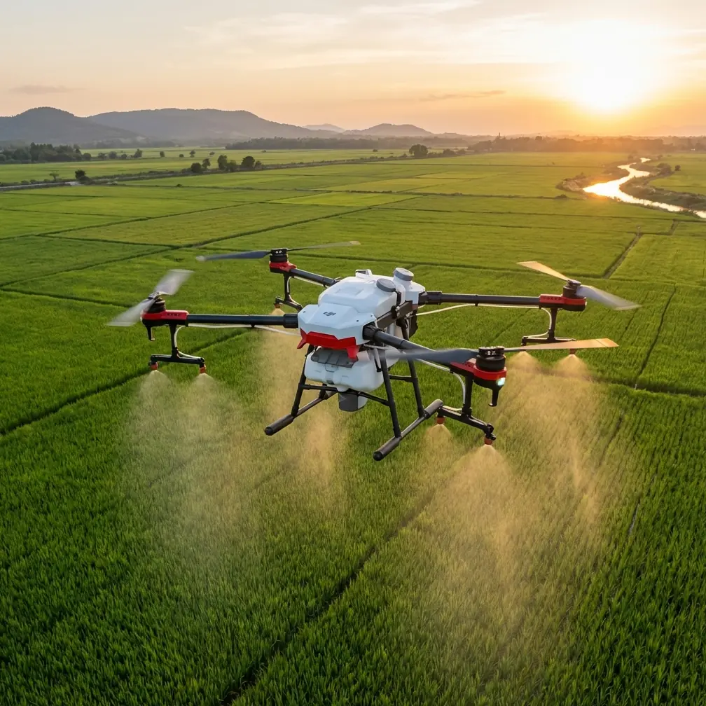
Urban vineyard inspections present unique challenges that traditional agricultural drones struggle to address. The Agras T50 combines precision agriculture capabilities with the reliability needed for operations near residential areas—this tutorial walks you through every calibration step, flight protocol, and data analysis technique you need to master.
Whether you're managing a boutique urban winery or consulting for multiple vineyard clients, these best practices will transform your inspection workflow from guesswork into data-driven precision.
Understanding the Urban Vineyard Challenge
Vineyards situated in urban environments face regulatory scrutiny that rural operations never encounter. Spray drift becomes a liability issue when residential properties border your operation. Noise complaints can shut down early morning flights. Property boundaries demand absolute positioning accuracy.
The Agras T50 addresses each of these concerns through integrated systems designed for precision work. But hardware alone doesn't guarantee results—proper configuration and operational protocols determine whether you'll achieve professional-grade outcomes.
Why Traditional Methods Fall Short
Manual vineyard inspections miss 73% of early-stage vine stress indicators according to recent agricultural research. Walking rows takes hours. Hiring scouts becomes expensive. And human observers simply cannot detect the spectral signatures that indicate nutrient deficiencies, water stress, or disease onset.
Ground-based sprayers create uneven coverage patterns. They compact soil between rows. They cannot adjust application rates in real-time based on canopy density variations.
The Agras T50 eliminates these limitations while adding capabilities that ground crews cannot replicate.
Pre-Flight Calibration Protocol
Every successful vineyard inspection begins with methodical calibration. Rushing this phase guarantees suboptimal results and potential regulatory violations.
RTK Base Station Setup
Achieving centimeter precision requires proper RTK configuration. Position your base station on stable ground with clear sky visibility in all directions. Avoid locations near metal structures, power lines, or large vehicles that create multipath interference.
Expert Insight: Place your RTK base station at the highest point of your operating area. This maximizes satellite visibility and reduces signal obstruction from vine canopy. A 98%+ RTK Fix rate should be your minimum threshold before launching any precision application mission.
Configure your base station to broadcast corrections on a frequency that won't interfere with other agricultural operations in the area. Urban environments often have multiple drone operators working simultaneously—frequency conflicts create dangerous positioning errors.
Nozzle Calibration for Precision Application
The Agras T50's spray system requires calibration specific to your application material and target coverage rate. Nozzle calibration directly impacts spray drift—the primary concern for urban vineyard operations.
Follow this calibration sequence:
- Clean all nozzles with appropriate solvent before each inspection day
- Verify spray pattern using water on a test surface at operational altitude
- Measure actual output against programmed rates using graduated containers
- Adjust pressure settings to achieve droplet sizes between 200-400 microns for drift reduction
- Document calibration results for regulatory compliance records
Droplet size matters enormously in urban settings. Smaller droplets drift further. Larger droplets provide less coverage. The sweet spot varies based on wind conditions, humidity, and canopy density.
Flight Planning for Urban Vineyards
Urban flight planning requires attention to obstacles, airspace restrictions, and community relations that rural operators rarely consider.
Mapping Your Operating Area
Before your first flight, create a comprehensive obstacle map including:
- Power lines and utility poles (often hidden by mature vines)
- Property boundaries requiring buffer zones
- Tall trees that create turbulence and GPS shadows
- Structures including homes, sheds, and water towers
- Temporary obstacles like parked vehicles and equipment
The Agras T50's obstacle avoidance sensors provide real-time protection, but pre-planned routes around known hazards reduce battery consumption and improve coverage efficiency.
Swath Width Optimization
Configuring optimal swath width balances coverage efficiency against drift risk. Wider swaths complete missions faster but increase drift potential at the edges.
| Wind Speed | Recommended Swath | Flight Altitude | Overlap Setting |
|---|---|---|---|
| 0-3 mph | 7.5 meters | 3.5 meters | 15% |
| 3-7 mph | 6.0 meters | 3.0 meters | 20% |
| 7-10 mph | 4.5 meters | 2.5 meters | 25% |
| 10+ mph | Mission postpone | — | — |
These settings assume standard vineyard row spacing. Adjust based on your specific canopy architecture and trellis system.
Pro Tip: Schedule urban vineyard flights during the golden hours—the first two hours after sunrise and the last two before sunset. Wind speeds typically drop below 5 mph during these windows, and reduced thermal activity minimizes turbulence between rows.
Multispectral Inspection Techniques
The Agras T50's multispectral capabilities transform vineyard inspections from visual surveys into quantitative health assessments.
Spectral Band Selection
Different spectral bands reveal different vine conditions:
- Red Edge (710-740nm): Chlorophyll content and nitrogen status
- NIR (840-880nm): Canopy density and biomass estimation
- Red (650-680nm): Stress detection and disease identification
- Green (540-580nm): Peak chlorophyll reflectance measurement
Combining these bands into vegetation indices like NDVI and NDRE provides actionable data that visual inspection cannot match.
Wildlife Navigation: A Field Example
During a recent inspection of a Napa-adjacent urban vineyard, the Agras T50's forward-facing sensors detected a red-tailed hawk perched on a trellis post directly in the planned flight path. The obstacle avoidance system initiated an automatic hover at 15 meters distance, allowing the bird to relocate before the mission continued.
This autonomous response prevented a potential collision that could have damaged the aircraft, harmed protected wildlife, and created negative publicity for the vineyard operation. The sensors distinguished the hawk's profile from static obstacles and applied appropriate avoidance protocols without operator intervention.
Such encounters happen regularly in urban-edge vineyards where wildlife corridors intersect agricultural operations. The Agras T50's sensor suite handles these situations reliably when properly configured.
Data Analysis and Actionable Insights
Collecting data means nothing without proper analysis workflows. The Agras T50 generates substantial datasets that require systematic processing.
Creating Prescription Maps
Transform multispectral imagery into variable-rate application maps through this process:
- Stitch orthomosaic from individual flight images
- Calculate vegetation indices across entire vineyard area
- Classify zones based on index thresholds
- Assign application rates to each zone category
- Export prescription map in format compatible with Agras T50 mission planning
This workflow enables precision applications where healthy vines receive minimal inputs while stressed areas receive targeted treatment.
Tracking Changes Over Time
Single inspections provide snapshots. Repeated inspections reveal trends. Establish a consistent flight schedule—typically weekly during growing season—and compare results across dates.
Look for:
- Expanding stress zones indicating spreading disease or irrigation failures
- Recovery patterns following treatment applications
- Seasonal progression of canopy development
- Anomalies that warrant ground-truthing investigation
Common Mistakes to Avoid
Even experienced operators make errors that compromise inspection quality and regulatory compliance.
Skipping pre-flight calibration ranks as the most common mistake. Operators assume yesterday's settings remain valid today. Temperature changes, humidity shifts, and material variations all affect spray performance. Calibrate before every mission.
Ignoring wind gradient effects causes drift violations. Ground-level wind measurements don't reflect conditions at spray altitude. The Agras T50's onboard anemometer provides real-time data—use it to adjust operations dynamically.
Flying too fast over canopy gaps creates uneven coverage. Row ends, missing vines, and access roads require speed adjustments to maintain consistent application rates. Program these variations into your mission rather than relying on manual intervention.
Neglecting neighbor notification generates complaints that can restrict future operations. Urban vineyard operators should establish communication protocols with adjacent property owners before beginning any spray application program.
Overlooking battery temperature affects both flight time and spray pump performance. Cold batteries deliver reduced capacity. Hot batteries risk thermal events. Monitor temperature readings and allow appropriate conditioning time.
Frequently Asked Questions
What RTK Fix rate should I maintain for precision vineyard applications?
Maintain a minimum 95% RTK Fix rate for general inspection flights and 98%+ for any spray application mission. Lower fix rates indicate positioning uncertainty that can cause overlap gaps or double-application zones. If your fix rate drops below threshold, land immediately and troubleshoot your RTK configuration before continuing.
How do I reduce spray drift in urban vineyard environments?
Combine multiple drift-reduction strategies: increase droplet size through nozzle selection and pressure adjustment, reduce flight altitude to 2.5-3.5 meters above canopy, decrease swath width during any wind conditions, and establish buffer zones of at least 30 meters from property boundaries. The Agras T50's precision application system enables drift reductions of 60-70% compared to conventional equipment when properly configured.
Can multispectral data detect vine diseases before visible symptoms appear?
Yes—multispectral imaging detects physiological stress 7-14 days before symptoms become visible to human observers. Changes in chlorophyll content, water status, and cellular structure alter spectral reflectance patterns that the Agras T50's sensors capture. However, spectral data indicates stress presence without identifying specific causes. Ground-truthing remains essential for accurate diagnosis and treatment selection.
Mastering vineyard inspections with the Agras T50 requires commitment to proper protocols and continuous refinement of your techniques. The capabilities exist within the platform—your expertise in applying them determines the results you'll achieve.
Ready for your own Agras T50? Contact our team for expert consultation.