Agras T50 in Mountain Venues: A Practical Field Guide
Agras T50 in Mountain Venues: A Practical Field Guide to Terrain, Coverage, and Mid-Flight Change
META: Expert tutorial on using the Agras T50 for mountain venue inspection and agricultural-style flight planning, with terrain-following logic, battery care, spray system maintenance, observer coordination, and weather-response insight.
Mountain venues expose a drone operation for what it really is. Flat-ground assumptions disappear fast. Elevation shifts distort line of sight, wind behaves differently from one slope to the next, and coverage planning becomes a geometry problem instead of a simple grid.
That is exactly why the Agras T50 deserves to be discussed in a terrain-specific way, not as a generic spray platform.
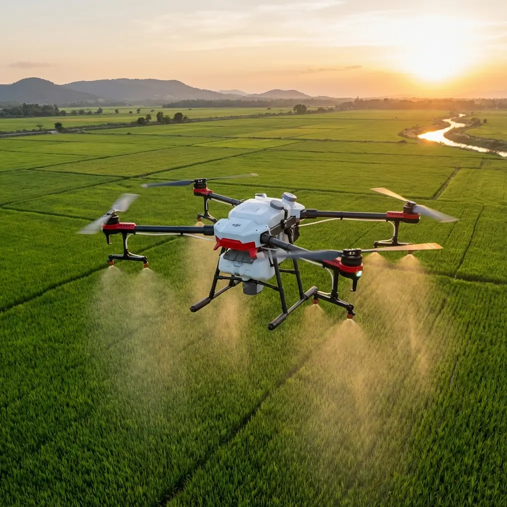
If you are inspecting venues in mountainous areas—orchards, tea slopes, hillside event grounds, terraced properties, access corridors, or mixed agricultural-commercial sites—the T50’s value is not just payload or throughput. It is how well the aircraft can support consistent low-altitude work when the ground itself refuses to cooperate. The operational mindset matters more than the brochure headline.
This guide takes a useful cue from an educational drone exercise built around a hillside tea garden. In that example, the slope height is 35 cm, the right-side slope length is 100 cm, the left-side slope is 50 cm, the width is 120 cm, and the route spacing is 30 cm, while the drone maintains 80 cm above the crop. Those are classroom numbers, but the lesson scales directly to real mountain work: what matters is not altitude above takeoff point, but altitude relative to the target surface.
For venue inspection, that distinction changes everything.
Why mountain venue work should be planned like precision crop work
People often separate “inspection” from “agricultural flight,” but on mountain terrain they share the same core challenge: hold a repeatable relationship to the surface below while preserving coverage and avoiding drift in data quality.
In the tea-garden training scenario, the route uses a back-and-forth pattern across the slope so the aircraft stays aligned with the terrain instead of forcing a flat horizontal path. That matters operationally because a drone flying a constant height above launch point would be too high over one section and too low over another. In spraying, that means uneven deposition. In venue inspection, it means uneven image scale, unstable angle of observation, and inconsistent defect visibility.
With the Agras T50, the practical takeaway is simple: when inspecting mountain venues, build your mission around terrain-relative passes. Think in terms of swath width, overlap discipline, and centimeter precision rather than just “covering the area.”
If you are documenting retaining walls, drainage routes, hillside access lanes, spectator areas, vegetation encroachment, or service zones, the T50’s mission planning should preserve a stable standoff from the ground surface wherever possible. That improves consistency in both visual inspection and any multispectral or plant-health interpretation used around landscaped or agricultural-adjacent sites.
Start with route geometry, not with the aircraft
A strong T50 mission begins before props spin.
The TT educational example uses 30 cm spacing between flight lines. In real T50 field operations, you would scale that spacing to your objective, nozzle setup if spraying is involved, wind condition, terrain shape, and the detail level required for inspection. The point is not the exact number. The point is disciplined interval control.
Mountain venues usually punish lazy spacing in two ways:
- Gaps appear where the operator assumed the slope was more uniform than it actually was.
- Excess overlap wastes time and battery while still missing the angle that reveals the real issue.
For example, a venue inspection over a stepped hillside may need one pattern for the broad slope face and another for edges, transitions, and narrow service tracks. A single “one-size-fits-all” sweep often leaves blind spots near cut banks, tree lines, or fencing.
The T50 is especially useful when you treat route planning as a layered task:
- primary passes for broad area coverage
- tighter secondary passes for terrain breaks
- manual or semi-automated verification around obstructions
- final confirmation passes if weather shifts during the mission
That last point matters more in mountains than many operators admit.
When the weather changes mid-flight
On open slopes, weather rarely changes politely. It bends around ridges, accelerates through saddles, and pushes across exposed sections in short bursts. A calm takeoff can become a crosswind management exercise a few minutes later.
During one mountain venue workflow, the flight may begin with stable air over the lower approach and then hit a variable wind band halfway up the slope. That is where the T50’s operational value shows up—not because any aircraft can defeat weather, but because a serious platform allows the crew to manage changing conditions methodically.
What should happen when weather shifts mid-flight?
First, the pilot should not chase the aircraft reactively. The route should be reassessed in terms of target-relative stability. If the wind begins to push the aircraft off line, the concern is not just positional drift. It is whether the intended inspection geometry or spray pattern is still valid.
Second, the observer becomes critical. One of the reference documents states clearly that coordination between the observer and pilot directly affects safety, especially where the aircraft moves beyond the pilot’s best visual reach. In mountain venues, this is not a procedural extra. It is core risk control. An observer who can continuously report aircraft position, attitude trend, and nearby obstacles helps preserve both safe separation and coverage integrity.
Third, the crew should be honest about drift. If the wind introduces spray drift risk, inspection blur, poor RTK fix stability, or unstable ground clearance, the correct move may be to pause, reposition, or segment the task differently. Finishing a compromised route is not efficiency.
This is one reason operators care about RTK fix rate and centimeter precision in terrain work. On mountain sites, precision is not only about map neatness. It helps the aircraft maintain confidence in where it is relative to a route that may run near trees, poles, cables, terraces, or steep grade changes. The better the positional reliability, the better the crew can judge whether a weather change is still within workable limits.
Spray drift and venue-adjacent operations
Even when the primary mission is inspection, many readers interested in the Agras T50 are also managing vegetation, dust suppression, or site-edge plant treatment. On a mountain venue, spray drift is never an abstract concept.
A crosswind on a slope does not just move droplets sideways. It can carry them uphill, lift them above the intended layer, or push them into sensitive adjacent spaces. That is why nozzle calibration and route height discipline matter. If the route was designed to maintain a controlled height relative to the surface—as in the tea-slope training scenario where the aircraft stays 80 cm above the tea trees—the operator has a better chance of preserving uniform application.
Translate that to the T50: accurate terrain-following supports more predictable deposition, but only if the spray system itself is in order. Nozzle calibration is not glamorous, yet poor calibration can undo even a well-planned route. Uneven flow across nozzles means one pass is effectively multiple different application rates. On mixed mountain terrain, that inconsistency often goes unnoticed until the results show up in crop condition, ground staining, or under-treated strips.
If you are using the T50 around venues with landscaped perimeters, tea rows, orchard edges, or embankment vegetation, control begins with the route but finishes at the nozzle.
The maintenance habits that actually protect T50 performance
One of the strongest operational details in the reference material has nothing to do with flight path. It is post-task cleaning.
The agricultural operations document warns that chemical residue can corrode the airframe, metal structures, pump, nozzles, and tubing if the aircraft and spray system are not cleaned immediately after work. It also notes that thicker agents can clog pumps and nozzles if left sitting, reducing flow during the next mission.
This is not theoretical. On a platform like the Agras T50, degraded flow integrity affects more than spray quality. It affects confidence. Once operators start doubting whether the system is delivering evenly, every mission becomes slower and more conservative.
For mountain venues, where travel time to site can be significant and weather windows may be short, that kind of preventable unreliability is expensive in all but name.
So the right habit is simple: clean the aircraft and the full spray path as soon as the day ends. Not later. Not “before the next mission.” Immediately after task completion. This preserves pump health, nozzle consistency, and system readiness.
The same document also gives battery guidance that deserves more attention from T50 crews. Before use, battery charge sufficiency should be checked, and the voltage difference between battery cells should remain under 0.2V. If the cell difference grows too large, balancing through low-current trickle charging is recommended before normal use. For storage, the reference gives 3.85V as the proper storage voltage, and during the off-season it recommends 2–3 charge cycles per month.
Why does this matter for mountain work specifically?
Because mountain operations magnify the cost of battery weakness. A pack that looks acceptable on paper but has poor cell balance may show its problem sooner under terrain-related load changes, repeated climbs, hover corrections in shifting wind, or stop-start route segments. Good battery discipline is not just about longevity. It is about predictable power delivery when terrain complexity keeps raising the demand profile.
Training logic matters more than many operators think
There is a broader industry signal behind all this. Recent domestic policy direction around the low-altitude economy points to a shift from pure technical experimentation toward real industrial deployment. That transition matters for Agras T50 users because the market is no longer built only on whether a drone can fly. It is built on whether teams can operate repeatably, train effectively, and maintain systems professionally.
The educational material referenced here is a good example of how serious operators should think. It does not start by glorifying the machine. It starts with coordinate flight, route planning, geometric path design, terrain-relative movement, and visible task-state signaling through LED status changes. In the tea-slope example, the aircraft flies forward 30 cm from flat ground to the work area, begins simulated spraying with a green light, loops the task 2 times, then marks completion with a red light and backs out 30 cm before landing.
Scaled up to the Agras T50, that sequence reinforces a mature operational principle: define entry, active work zone, completion state, and exit path clearly. That structure is useful in mountain venue inspections as well. It reduces ambiguity between pilot, observer, and ground support.
If your team is building mountain inspection workflows around the T50, train those workflows as procedures, not as improvised flying. A repeatable entry path, work-state confirmation, obstacle callout language, weather threshold rules, and post-flight cleaning routine will do more for mission quality than raw stick skill alone.
Where the T50 fits in a modern mountain workflow
The Agras T50 makes the most sense when you view it as part of a disciplined field system:
- a route platform that can hold consistent terrain-relative passes
- a precision tool whose results depend on nozzle calibration and swath planning
- an aircraft that benefits from strong RTK fix rate in broken terrain
- a field asset that demands immediate cleaning after spray work
- a battery-dependent system where cell balance and 3.85V storage practice directly affect readiness
- a crewed workflow where observer-pilot coordination protects both safety and coverage
That is also where broader industry momentum becomes relevant. As policy support pushes the low-altitude economy toward industrial-scale implementation, operators who succeed will not be the ones with the loosest claims. They will be the teams who can execute on slopes, in changing weather, with disciplined maintenance and documented procedures.
If you are evaluating a mountain venue and want to compare route logic, coverage assumptions, or terrain-specific setup notes for the T50, you can share your site details through this field discussion link: https://wa.me/85255379740
Final field takeaway
The Agras T50 is not interesting because it is large or modern. It is interesting because mountain work exposes whether a drone operation has structure behind it.
The reference tea-garden exercise teaches the right lesson: terrain-relative flight is the foundation. The agricultural maintenance document adds the rest of the truth: performance is preserved on the ground, after the mission, through cleaning discipline and battery care. Add observer coordination and realistic weather judgment, and the T50 becomes far more than a generic platform for “coverage.”
It becomes a reliable mountain operator’s tool.
Ready for your own Agras T50? Contact our team for expert consultation.