Agras T50 in Remote Venue Inspection: A Field Report
Agras T50 in Remote Venue Inspection: A Field Report on When Payload Capacity Meets Emergency Logistics Thinking
META: A field report on how the Agras T50 fits remote venue inspection workflows, with practical analysis of payload, RTK precision, weather resistance, and lessons drawn from drone-enabled medical emergency transport in China.
Remote venue inspection rarely gets described with the urgency it deserves.
Yet anyone responsible for large outdoor sites, rural campuses, mountain event grounds, isolated resorts, or temporary infrastructure corridors knows the reality: when access is poor, roads are slow, and information is incomplete, the inspection problem stops being routine. It becomes a logistics problem first, and a data problem second.
That is why the most useful recent signal around drones did not come from a marketing brochure. It came from a very different operational setting. A recent report from UAVCN described how drones are being integrated into China’s medical emergency system to create an “air life corridor,” improving the transport efficiency of urgent supplies and rescue resources. The core lesson is bigger than healthcare. When the ground route is the bottleneck, air access changes the tempo of the entire response.
For professionals evaluating the Agras T50 for inspecting remote venues, that lesson matters.
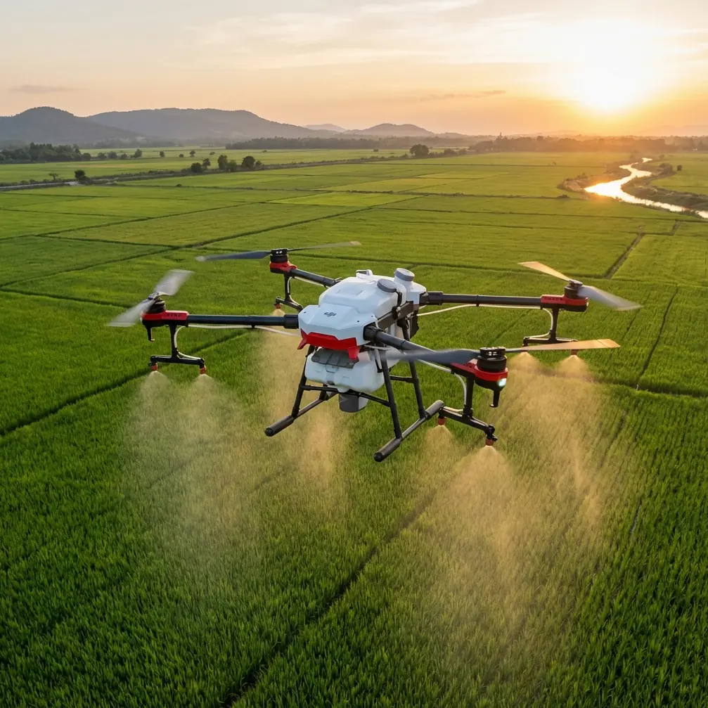
The T50 is often framed narrowly as an agricultural platform. That misses the operational logic behind the aircraft. In hard-to-reach environments, its value is not just about spraying. It is about carrying useful payloads into rough terrain, maintaining stable positioning, surviving punishing field conditions, and compressing the time between identifying a problem and acting on it. In that sense, the same idea behind an aerial medical support corridor has relevance for remote venue inspection: drones can serve as a practical supplement to traditional ground operations, not simply a replacement for them.
What remote venue inspection actually demands
Remote sites punish weak drone systems in predictable ways.
First, there is reach. Inspectors may need to cover scattered assets across a broad footprint: perimeter fencing, water storage, utility lines, temporary structures, access roads, slopes, drainage channels, crop-adjacent event spaces, or emergency egress points. Second, there is terrain complexity. Valleys, vegetation, dust, uneven lighting, and intermittent signal conditions expose any weakness in navigation and sensing. Third, there is the weather issue. A site that only gets inspected on perfect days is not being inspected under real-world conditions.
This is where the T50 starts to separate itself from lighter inspection drones.
Its architecture is built for field abuse. Operators familiar with the platform know that the aircraft’s larger format and mission-oriented design can make a real difference when the job extends beyond simple imaging. A remote venue may require inspection gear, marking fluid, small emergency supplies, or repeat visits over the same corridor. The T50’s working profile is far closer to an industrial field machine than to a camera drone with limited endurance and minimal carrying flexibility.
That distinction becomes even more relevant when inspections overlap with site readiness and incident response.
The healthcare drone analogy is more relevant than it looks
The UAVCN report focused on medical emergency use in China, where drones are being used to support the emergency care system and improve transport efficiency for critical materials and rescue resources. That use case is civilian, practical, and time-sensitive. It also reveals a deeper truth about drone deployment: the real gain is often not the flight itself, but the reconfiguration of the response chain.
Remote venue inspection works the same way.
Suppose a mountain sports venue needs pre-event verification after storms. A ground team may need hours to reach the affected zone, and by then a blocked service road or unstable slope may have already delayed remediation. An aircraft like the T50 can move first, establish situational awareness, and support decisions before heavier personnel or equipment arrive. In effect, it creates an aerial priority channel for information and, where needed, for limited material movement.
That is operationally significant because drones in these settings are not just sensors. They are force multipliers for site management.
The UAVCN report also described drones as a complement to traditional ground rescue methods. That idea maps almost perfectly onto venue inspection. A T50 should not be evaluated as if it replaces every vehicle, every crew, or every walkdown. It should be evaluated on how well it shortens the slowest part of the chain. In remote settings, the slowest part is usually access.
Why the Agras T50 deserves consideration beyond spraying
Let’s deal with the obvious point directly. The Agras T50 was designed with agriculture at its core. So why use it as part of a remote inspection workflow?
Because many remote venues share the exact environmental and operational constraints seen in commercial agriculture: large open areas, irregular obstacles, limited infrastructure, dust exposure, weather variability, and the need to accomplish work fast. The T50 was engineered for that world, and that shows.
Its robust weather sealing, often cited in connection with IPX6K-level durability, matters more than spec-sheet enthusiasts sometimes admit. At a remote venue, dust, splash, mud, and cleaning cycles are not occasional annoyances. They are routine. A drone that can tolerate aggressive field conditions is easier to integrate into recurring inspections, especially when turnaround time between missions is short.
The RTK component matters just as much. When operators discuss RTK fix rate and centimeter precision, the conversation can sound abstract. It is not. In remote venue inspection, repeatability is everything. You may need to re-fly a drainage path after heavy rain, compare edge encroachment near temporary structures, or verify whether a known crack, washout, or obstruction has expanded. Reliable RTK performance gives operators a better chance of reproducing flight paths and locating anomalies with consistency. That turns drone inspection from a one-off visual sweep into a measurable monitoring program.
Compared with lighter competing platforms that rely on simpler positioning and lower payload flexibility, the T50’s strength is not elegance. It is utility.
A field logic: inspect, verify, act
The strongest case for the T50 in remote venue inspection is not a single feature. It is a workflow.
1. Initial sweep
The aircraft conducts a broad-area pass over key zones: access roads, spectator boundaries, staging areas, drainage routes, utility runs, or terrain edges. If the venue sits near agricultural land or managed vegetation, the platform’s familiarity with low-altitude, structured field operations can be an advantage rather than a limitation.
2. Precision revisit
With centimeter-level positioning support through RTK, the operator can return to the exact problem area. This is where better fix reliability matters. A venue manager does not just want “a photo of the area.” They want to know whether the rut is 2 meters farther downslope than yesterday, whether standing water has expanded, or whether a temporary installation remains aligned with plan.
3. Targeted intervention
This is where the T50’s agricultural lineage becomes unexpectedly useful. In some remote civilian sites, intervention may include applying marker fluid, managing surrounding vegetation in controlled maintenance contexts, or transporting lightweight field essentials that help a ground team verify or secure an area. Not every inspection mission needs this. But when it does, a platform with real operational muscle has an edge over inspection drones that are all optics and no work capacity.
4. Ground team handoff
The drone is not the whole operation. It shortens uncertainty. That is exactly the lesson from the “air life corridor” concept in medical emergency systems: aerial tools improve the transport and allocation of critical resources, but they function best as part of a broader response network.
Where T50 features translate into venue inspection value
A few technical themes from the T50 ecosystem deserve practical interpretation.
Nozzle calibration and spray drift are not just farming concerns
At first glance, these seem irrelevant to inspection. They are not. If a remote venue uses the T50 for vegetation control around boundaries, service lanes, or safety buffers, nozzle calibration directly affects application accuracy. Poor calibration wastes material and increases off-target deposition. Spray drift becomes a site compliance issue, especially near public areas, water features, or adjacent sensitive zones. Operators who already understand drift management and swath width control can use the T50 more responsibly in mixed-use environments.
That matters because remote venues often sit in complex landscapes where maintenance and inspection overlap.
Swath width influences productivity
Even when a mission includes treatment or marking rather than pure imaging, swath width determines how quickly an area can be covered. On a large venue with multiple distributed sectors, productivity is not a cosmetic metric. It affects whether the drone can complete inspection-linked tasks inside a narrow weather window or before crews arrive on site.
Multispectral capability can expand the inspection brief
If a venue operator is managing large grounds, turf health, drainage stress, or vegetation encroachment, multispectral data can complement standard visual inspection. This is not mandatory for every T50 deployment, but in expansive outdoor venues it can reveal patterns that a normal camera pass misses, especially where surface appearance changes slowly over time.
The competitor comparison that actually matters
Many competing drones look cleaner on paper for inspection work because they are smaller, camera-centric, and easier to classify mentally as “survey tools.” But in remote venues, that can be the wrong comparison.
The more relevant question is this: what happens after the image is captured?
If the answer is “a separate crew must mobilize hours later to verify the same issue, carry the necessary materials, and work in the same difficult environment,” then the drone has only solved half the problem. The T50 excels when the mission is closer to operational field support than to pure aerial photography. That is where it often outperforms lighter competitors: resilience, repeatability, and the ability to contribute to action, not merely observation.
Its advantage is not subtle in harsh settings. It is the difference between an aircraft that visits a site and one that participates in the site’s workflow.
What I would watch before deployment
As an academic and field evaluator, I would not recommend deploying the T50 into a remote venue program without addressing three practical points.
First, mission definition must be precise. If the job is purely high-end imaging with no environmental stress and no intervention requirement, another platform may fit better. Second, RTK setup quality matters. Centimeter precision is meaningful only if the positioning workflow is disciplined. Third, any use involving fluid application or vegetation management demands strict attention to nozzle calibration, drift conditions, and area separation.
Those are not weaknesses. They are the normal disciplines of running an industrial drone program well.
If your team is assessing site suitability, operational boundaries, or field integration questions, a direct technical discussion is often more useful than generic brochures; I’d suggest starting with a practical conversation here.
The bigger takeaway
The most interesting thing about the recent UAVCN healthcare report is not simply that drones are helping transport emergency materials in China. It is that drone value becomes clearest when time, terrain, and access are working against you.
That is the same environment where remote venue inspection succeeds or fails.
The Agras T50 should be viewed through that lens. Not as a drone trying to impersonate a lightweight inspection camera platform, but as a serious field aircraft that can inspect, revisit, support, and integrate with the wider ground response. The “air life corridor” concept from medical emergency operations shows how aerial systems can supplement conventional logistics rather than waiting for roads and vehicles to do all the work. In remote venue management, that principle is powerful.
If your inspection challenge involves distance, rough conditions, repetitive monitoring, or the need to move from detection to action without losing half a day on access, the T50 deserves a much closer look than it usually gets.
Ready for your own Agras T50? Contact our team for expert consultation.