Agras T50 for Mountain Solar Farm Inspection
Agras T50 for Mountain Solar Farm Inspection: A Case Study in Turning Agricultural Drone Logic into Practical Field Mapping
META: A field-focused analysis of how the Agras T50 can support mountain solar farm inspection workflows by combining flight efficiency, precise navigation logic, and post-processing tools for fast 3D site understanding.
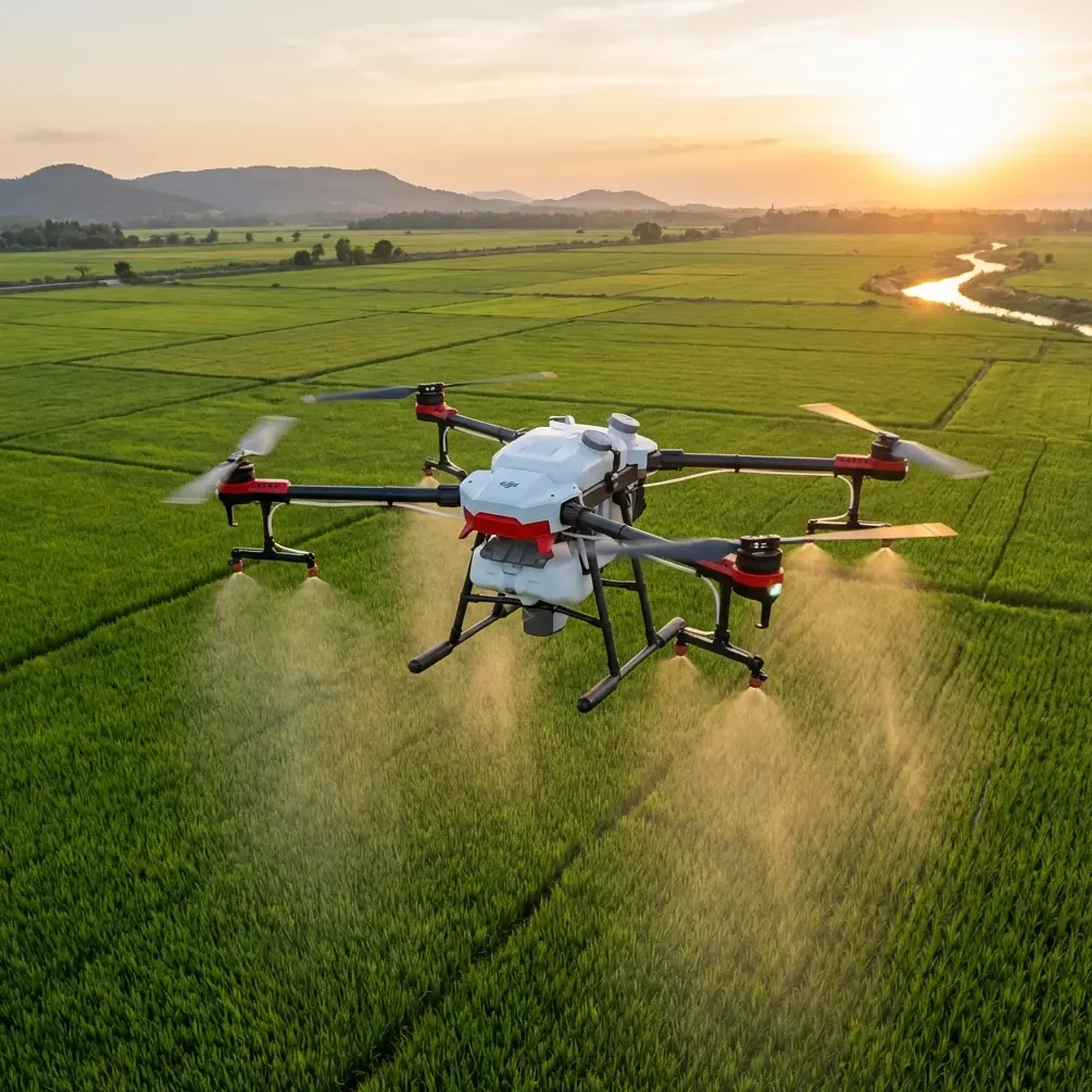
When people search for the Agras T50, they usually land in an agriculture conversation. That makes sense. The aircraft was built around demanding field operations where repeatability, payload stability, and route discipline matter every day.
But there is another angle worth examining: what happens when the operating logic behind a modern plant-protection drone is applied to mountain solar farm inspection?
That question matters because utility-scale solar sites in hilly terrain create a strange mix of operational problems. Access roads are narrow. Elevation changes break line-of-sight. Panel blocks are spread across uneven ground. After rain, subsidence, washouts, and vegetation creep can show up in places crews do not discover until much later. A conventional walk-through is slow. A light consumer drone can collect visuals, but it often struggles to support disciplined, repeated coverage over large areas. The Agras T50 sits in an interesting middle ground. It comes from a category shaped by high-efficiency agricultural work, yet many of those same traits translate well to inspection tasks when used within a civilian, site-management workflow.
Why the T50’s agricultural DNA matters in a solar inspection job
The broader drone industry did not arrive here overnight. Civilian UAV development only began in earnest in the 1980s, far later than the roughly century-long development arc of military drones. That timeline matters less as history trivia and more as a practical explanation for why today’s commercial aircraft are hybrids of inherited technical ideas and newer software-driven workflows. In plain terms, civilian operators now benefit from mature flight-control thinking, but the real breakthrough has been packaging those capabilities into repeatable, task-oriented tools.
The T50 belongs to that second phase. It is not interesting simply because it flies. It is interesting because it reflects how commercial drones have evolved from manually piloted machines into structured work platforms.
For mountain solar farm inspection, that shift is everything.
A site manager does not need cinematic footage. They need coverage they can trust. They need route consistency from one inspection cycle to the next. They need enough positional accuracy to compare terrain changes, drainage problems, access road degradation, fence-line encroachment, and obvious infrastructure anomalies. They also need an aircraft that can operate in dirty, wet, windy field conditions without behaving like a fragile lab instrument.
That is where the T50 begins to separate itself from lighter competitors. Many smaller inspection drones are easier to carry, but they often lack the physical presence and route discipline operators value when flying broad, repetitive patterns over complex ground. On a mountain solar site, “good enough” flight stability quickly turns into missed coverage.
A case study framework: inspecting a hillside solar plant after heavy weather
Imagine a solar farm laid out across stepped terrain, with panel rows bending around slopes and service roads crossing shallow drainage cuts. A storm system passes through. The owner wants a same-day inspection focused on four issues:
- Erosion near panel foundations
- Drainage blockage along internal roads
- Vegetation encroachment around string inverter zones
- Surface condition changes around retaining structures
This is not a spraying mission. Yet the operating demands resemble agricultural route work more than traditional photography. The drone must follow planned lanes, maintain stable movement over irregular terrain, and capture consistent image sets that can be compared later.
That is where the T50’s working style becomes useful.
Agricultural drones are designed to be productive over large areas without constant pilot improvisation. In crop work, that discipline influences swath management, overlap logic, and application uniformity. In inspection work, the same mentality supports structured visual collection. Instead of treating the site as a collection of isolated points of interest, the T50 can be used to treat the entire hillside as a system that needs repeatable aerial coverage.
Precision is not just a spec sheet issue
The reference material on rotor plant-protection aircraft points to a long-standing challenge in the sector: operators have relied on DGPS to improve navigation accuracy, or on software to correct coordinates later. That detail may sound dated, but it highlights something still relevant today. Precision in field drone work is never just about where the aircraft thinks it is. It is about whether the data collected can stand up to operational decisions afterward.
For solar inspection, this becomes critical when teams try to detect small changes over time. If one mission drifts relative to the last, apparent changes in the model may be positional noise rather than real terrain movement. That is why readers looking into terms like RTK fix rate and centimeter precision are asking the right question. The value is not abstract. Better positional discipline improves confidence when comparing one survey to the next.
The T50’s advantage, viewed through this lens, is less about headline capability and more about mission repeatability. On a mountain site, repeatability means you can refly the same corridor after a weather event and evaluate what actually changed. That is a far stronger operational outcome than simply collecting “high-resolution footage.”
From field capture to usable terrain intelligence
A drone inspection is only half done when the aircraft lands. The real value appears when imagery is turned into a usable model.
One of the most useful reference points here is the emergency mapping workflow built around DP-Smart and DP-Modeler. DP-Smart supports automatic aerial triangulation, dense point-cloud generation, TIN construction, and automated texture mapping from multi-source air-ground imagery. DP-Modeler then extends the process into integrated orientation, mapping, and modeling, including large-scale vector extraction in a real-scene photogrammetry environment.
Those details are operationally significant for a mountain solar site because raw imagery alone rarely answers infrastructure questions clearly. A true 3D model can.
If the T50 is used to capture systematic image sets over a hillside array, software in the DP-Smart class can rapidly generate a high-resolution real-scene model without manual intervention at every step. That matters in post-storm inspections, where speed affects maintenance response. Dense point clouds and TIN-based surface construction are not academic extras. They help teams identify slope deformation, runoff channels, access road edge failures, and embankment irregularities that may be hard to interpret from flat imagery.
This is where the T50 can outperform lighter competitor platforms that are often marketed around convenience rather than workflow depth. A smaller drone may be fine for quick visual checks of a few inverter pads. But once the job expands into structured corridor capture for terrain-aware modeling, the value shifts toward aircraft and software combinations built for repeatable field production.
Lessons borrowed from spray operations still apply
At first glance, spray drift and nozzle calibration have nothing to do with solar farms. Yet the underlying lesson from plant-protection research is surprisingly transferable: field performance depends on controlling variables, not just flying the aircraft.
The study on rotor crop-protection drones highlighted that spray quality is influenced by flight height, flight speed, meteorological conditions, route planning, and navigation automation. In agriculture, those variables affect droplet distribution. In inspection, they affect image consistency, overlap quality, motion blur, terrain representation, and model reliability.
So while nozzle calibration itself is not part of a solar inspection mission, the discipline behind it is. The best T50 operators do not approach inspection as free flight. They think in terms of parameter optimization: altitude relative to terrain, track spacing, overlap, turning behavior, wind margins, and lighting windows.
That mentality is one reason an agricultural platform can be surprisingly effective in infrastructure work. The aircraft category was born in an environment where sloppy operating habits quickly destroy results. On a mountain solar farm, that same discipline protects mapping quality.
Weather tolerance and site reality
Mountain solar installations are not gentle environments. Dust, residual moisture, mud splash, and wind shear are ordinary conditions, not exceptions. Readers often search for ruggedness markers such as IPX6K because ingress resistance influences whether an aircraft can be fielded consistently rather than selectively.
Even when ruggedness is not the only deciding factor, it changes how maintenance teams schedule work. If the aircraft needs ideal conditions every time, inspections get delayed. If the aircraft can be prepared, cleaned, and redeployed as part of a normal industrial routine, aerial surveys become operationally routine too.
This is one of the subtle strengths of using a platform like the T50 in a non-agricultural setting. It was conceived for repetitive outdoor work in contamination-heavy environments. That does not eliminate weather constraints, but it does align the aircraft with the real-world messiness of mountain energy assets better than many fragile alternatives.
Where competitors usually fall short
Competitor drones often win on portability, and that is not trivial. Hiking to a remote string block with a compact aircraft is undeniably convenient.
But convenience is not the same as throughput.
On large hillside solar sites, the real bottleneck is often mission consistency across repeated sectors, not takeoff simplicity. Operators need broad-area coverage, reliable route execution, and data that supports modeling rather than isolated snapshots. The T50’s field-work heritage gives it an edge here. It is better understood as a production platform than as a flying camera.
That distinction matters most when an inspection program is ongoing rather than occasional. Once the site owner wants baseline mapping, periodic reinspection, and event-based response after storms, route repeatability and data structure become more valuable than pocket-sized convenience.
A practical workflow for mountain solar inspection with the T50
A sensible inspection workflow might look like this:
- Segment the solar farm into terrain-based blocks rather than purely electrical blocks.
- Plan repeatable flight lanes that reflect slope direction, row orientation, and access-road geometry.
- Capture imagery with stable overlap designed for 3D reconstruction, not just visual review.
- Refly key drainage and retaining-wall corridors after weather events using the same geometry.
- Process image sets into dense point clouds and TIN-backed terrain models using software like DP-Smart.
- Use integrated mapping tools such as DP-Modeler to extract measurable features and compare changes over time.
That final step is where the project becomes actionable. The output is no longer “drone data.” It becomes engineering support for maintenance prioritization.
If your team is exploring whether this kind of workflow fits your site, a quick technical discussion can save a lot of trial and error: message a UAV workflow specialist here.
What this says about the Agras T50’s place in the market
The most interesting thing about the Agras T50 is not that it crosses categories. It is that the commercial drone market has matured enough for category boundaries to blur usefully.
The historical record shows civilian UAVs emerged much later than military platforms, and their growth was driven by technology transfer into commercial use. Today, that transfer is no longer the whole story. The more important evolution is internal to the civilian market itself. Agricultural automation, emergency mapping, and industrial inspection are increasingly sharing methods: precise navigation, automated route execution, and model-driven interpretation.
The T50 sits right at that intersection.
For mountain solar farm inspection, it should not be viewed as a novelty substitute for a survey drone, nor as a simple agricultural machine looking for extra work. Its real value is that it brings a high-discipline field operating model into an inspection environment that often suffers from inconsistency.
That is why details from the reference material matter so much. The older plant-protection literature emphasized navigation precision and the need to optimize flight parameters under changing environmental conditions. The mapping solution documents emphasized automated aerial triangulation, dense point-cloud generation, TIN construction, and integrated modeling. Put those together, and you get the blueprint for a serious mountain solar inspection workflow: precise flight in difficult terrain, followed by fast transformation of imagery into decision-ready 3D outputs.
For teams responsible for large solar assets in uneven terrain, that combination is far more valuable than another round of ad hoc visual checks.
Ready for your own Agras T50? Contact our team for expert consultation.