Agras T50 in Complex Terrain: A Field Case Study
Agras T50 in Complex Terrain: A Field Case Study on Inspection, Data Confidence, and Operational Control
META: A practical case study on using the Agras T50 in complex terrain for inspection-style fieldwork, blending ultra-low-altitude image capture, geotagged sample points, compliance workflows, and operational precision.
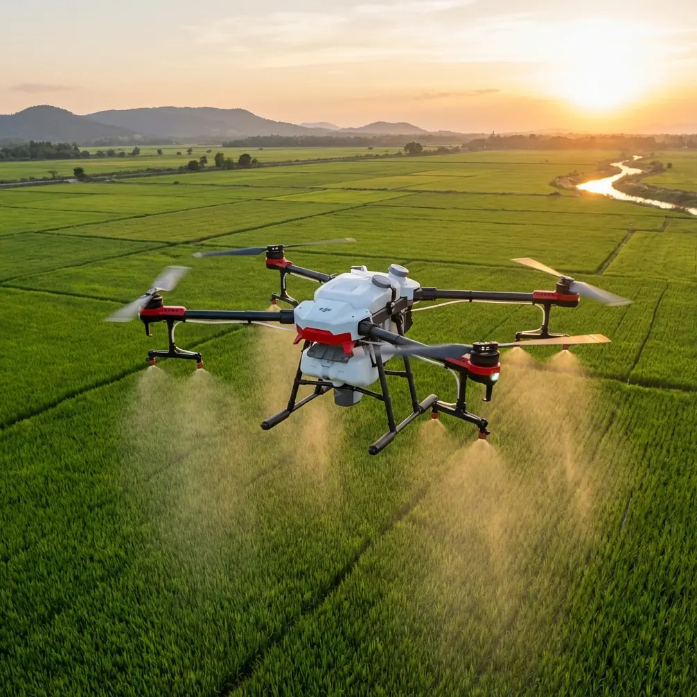
When people talk about the Agras T50, the conversation usually defaults to payload, productivity, and spraying. That misses a more interesting reality. In rough terrain, especially along utility corridors and fragmented agricultural edges, the real value of a heavy-duty platform is not just output. It is control under messy conditions.
I worked through a recent project scenario that captures this well: inspecting power-line-adjacent farmland in broken terrain where the vegetation pattern mattered, the slope changed by the minute, and the orthomosaic alone was not enough to answer basic operational questions. The aircraft at the center of the workflow was the Agras T50, but the story is really about how a platform like this fits into a larger evidence chain: what the drone sees, how that data is tied to the map, and how the operator proves the work was performed responsibly.
That distinction matters more now than it did a few years ago.
A clue comes from outside the agriculture segment. DJI’s position in the action, panoramic, and wearable camera market recently reached 66.2% share, yet the same market is seeing revenue growth paired with profit pressure. In plain terms, demand is still expanding, but competition is forcing faster product cycles and greater efficiency. That dynamic carries over into enterprise drone operations as well. Owning capable hardware is no longer the differentiator by itself. The edge comes from running cleaner workflows, collecting better evidence, and reducing wasted passes, bad interpretations, and compliance friction.
That is exactly where an Agras T50 program can either look sophisticated on paper or actually perform.
The terrain problem: when the map is not enough
In this case, the client’s concern started with inspection around power-line routes crossing cultivated parcels and uneven access lanes. The initial plan was straightforward: use aerial imagery to identify crop condition, obstruction points, and areas where future aerial application would face elevated drift or route-pluning risk.
The orthophoto looked sharp. It still was not enough.
This is not a software failure. It is a field reality. Even after enlarging the orthorectified image, the office team could not reliably identify certain crops by leaf detail alone. That exact problem appears in the ArcGIS collection workflow described in the reference material: even when the imagery is enlarged to its available resolution, it may still be impossible to determine the specific crop type from the orthomosaic. The operational significance is huge. If you cannot correctly identify what is on the ground, then every downstream decision becomes weaker—spray planning, drift assessment, nozzle selection, buffer design, and route safety around poles and conductors.
So instead of pretending the map answered everything, the team changed altitude and changed method.
They sent the aircraft on ultra-low-altitude passes specifically to capture photos clear enough to show the crop leaves. That is one of the most useful ideas in the reference set and one that deserves more attention from T50 operators. A large agricultural drone is often judged by hectares per hour. But in difficult environments, its value may come from slowing down, getting lower, and collecting decisive visual evidence that the high-level map cannot provide.
Why ultra-low sample capture changes the quality of decisions
For power-line-adjacent fieldwork, low-altitude sample imagery does three jobs at once.
First, it validates what the office thinks it sees. A swath that looks uniform from above may actually contain mixed planting, stress signatures, or obstacle encroachment hidden by canopy geometry.
Second, it sharpens spray-risk planning. If you are evaluating spray drift exposure around lines, roads, or adjacent plots, leaf architecture and canopy density matter. Nozzle calibration is never just about output volume. It is about matching droplet behavior to the crop and the corridor. A wrong assumption at the identification stage can cascade into over-application, under-coverage, or unnecessary drift mitigation that slows the operation without improving safety.
Third, it improves route realism. Complex terrain changes rotor wash behavior, approach angle, and operator sightlines. If a T50 mission will later transition from inspection-style reconnaissance to treatment work, the sample photos help define where the aircraft can safely maintain a consistent swath width and where it should not.
This is where the platform’s stability and positioning discipline become more meaningful than brochure specs. Centimeter precision and strong RTK fix rate are not abstract ideals in this setting. They affect whether repeat sample points line up with actual field conditions and whether later missions can use the same reference geometry with confidence.
The overlooked ArcGIS step that makes the photos useful
Collecting sample photos is easy. Making them usable at scale is where many teams lose momentum.
The ArcGIS workflow in the reference material solves a common pain point with a very specific tool: GeoTagged Photos To Points in ArcMap, located under Data Management Tools -> Photos -> GeoTagged Photos To Points. The importance of that tool is not technical trivia. It is what turns a folder of disconnected field photos into mapped evidence.
The software reads GPS information from each image and writes that location into a point layer. Even better, if the output is stored in a File GDB, the image itself can be attached to each point record. That matters because the photo is no longer just “some leaf image from the day of the flight.” It becomes a clickable, auditable field sample tied to a known location.
The reference makes a subtle but critical warning: if the output is created as a Shape File instead of a GDB, the option to attach photos is unavailable. Operationally, that is a bad compromise for inspection-grade work. In a power-line corridor project, where multiple stakeholders may review the findings—field crews, agronomy staff, GIS analysts, and operations managers—detached photos create ambiguity. A File GDB workflow preserves traceability. You click the point, and the exact sample image is there.
That is not a minor convenience. It is how you prevent arguments later.
Where the Agras T50 fits in a non-routine mission profile
The Agras T50 was not designed as a pure utility inspection aircraft, and that is fine. In mixed agricultural corridors, especially where power infrastructure intersects active crop land, the most effective aircraft is often the one already central to the operation. If the same machine can support reconnaissance, sample-image acquisition, and later application planning, the workflow gets tighter.
For that reason, I like the T50 less as a “spray drone only” and more as a field operations platform.
In practical terms, here is where it showed value in this scenario:
- It could work close to the canopy to capture clear leaf-level imagery.
- It could support repeatable positioning for sample collection and route validation.
- It could feed evidence into a GIS workflow that distinguished confirmed conditions from assumptions.
- It could later inform application parameters such as spray drift control, nozzle calibration, and expected swath width in terrain transitions.
One useful addition in this project was a third-party high-visibility strobe and marker kit mounted for corridor-awareness work during low-light survey windows. Not for gimmicks, and not as a substitute for proper planning. Simply to improve aircraft conspicuity for the visual support team when operating near broken ridgelines and utility access tracks. Accessories only matter when they solve a real field problem. This one did.
Compliance is not a side issue in corridor operations
Complex terrain near infrastructure has a way of exposing weak operating culture. Teams that treat compliance as paperwork tend to discover its importance at the worst time.
The regulatory references provided here point to several requirements that directly affect a serious T50 operation. One is the need to apply to the relevant control authority before operations and provide an effective monitoring method. In a corridor environment, that requirement has obvious significance. You are not just flying over an open field. You are operating in airspace and terrain where situational awareness, deconfliction, and accountability matter.
Another reference point is operator structure. The rules specify that the operator should designate one or more responsible task leads, and that the task lead must hold the appropriate civil UAV pilot qualification and corresponding level, along with the required knowledge and technical training. For anyone using the T50 around power lines and agricultural parcels, this is more than a licensing checkbox. It defines who is actually responsible when field conditions diverge from the plan.
There is also a strong systems angle in the source material that many operators overlook. The document calls for a drone cloud provider to maintain databases for pilots, operators, and operational status, enabling clear management of licensed personnel and monitoring of activities. It also requires systems to be updated and expanded regularly so that operators have convenient access, reliable data, low latency, and real-time valid flight-area information. The provider must also submit reports every 6 months covering connected aircraft numbers, operator counts, technical progress, operational difficulties, and accident or incident precursors.
Why does that matter to a T50 user on the ground?
Because the future of heavy-duty drone operations is not just aircraft capability. It is system reliability. If your flight-area information is stale, your monitoring chain is weak, or your operator records are inconsistent, then high-performance hardware does not rescue the mission. It amplifies the consequences of weak oversight.
Inspection lessons that carry directly into spraying work
Even though this case revolved around power-line-adjacent inspection and field verification, the lessons transfer directly into agricultural application planning.
If the office team cannot distinguish crop types from the orthomosaic, low-altitude sample capture should become standard before treatment design.
If geotagged evidence is not being attached to mapped sample points, quality control is weaker than it appears.
If RTK performance is unstable, repeated route use in fragmented terrain becomes harder to trust.
If nozzle calibration is based on generalized assumptions rather than field-verified crop structure and boundary risk, spray drift management becomes reactive instead of engineered.
And if the operation lacks a trained responsible lead with documented authority, the mission may be organized, but it is not truly controlled.
The strongest T50 operators understand that precision starts before the spray tank is relevant. It starts with identification, location confidence, and documentation discipline.
Why this matters right now
The broader market signal is clear. When a company can hold 66.2% share in adjacent imaging categories while still facing margin pressure from faster iteration and heavier channel investment, it tells us something about the entire drone ecosystem. Capability is increasingly common. Efficiency is where professional operators separate themselves.
That efficiency is not about rushing.
It is about avoiding avoidable ambiguity.
In this case, one small workflow decision—capturing ultra-low-altitude leaf-level photos and converting them into geotagged GIS points with attachments in a File GDB—made the difference between a plausible map and a defensible operational picture. Pair that with a disciplined T50 crew, strong RTK habits, careful calibration logic, and a compliance structure that respects pre-approval and operator responsibility, and the aircraft becomes far more than a spray platform.
It becomes part of a field intelligence system.
If you are building a similar workflow around the Agras T50 for difficult terrain, utility-adjacent farmland, or inspection-informed application planning, I’m happy to compare notes through this direct project chat. The details matter, especially when the terrain refuses to behave like a textbook.
The best Agras T50 programs are not the ones with the most dramatic flight footage. They are the ones where every low-altitude image, every mapped point, every route decision, and every compliance record supports the same thing: fewer assumptions, better judgment, and cleaner execution in the field.
Ready for your own Agras T50? Contact our team for expert consultation.