Agras T50 Inspecting Fields in Low Light
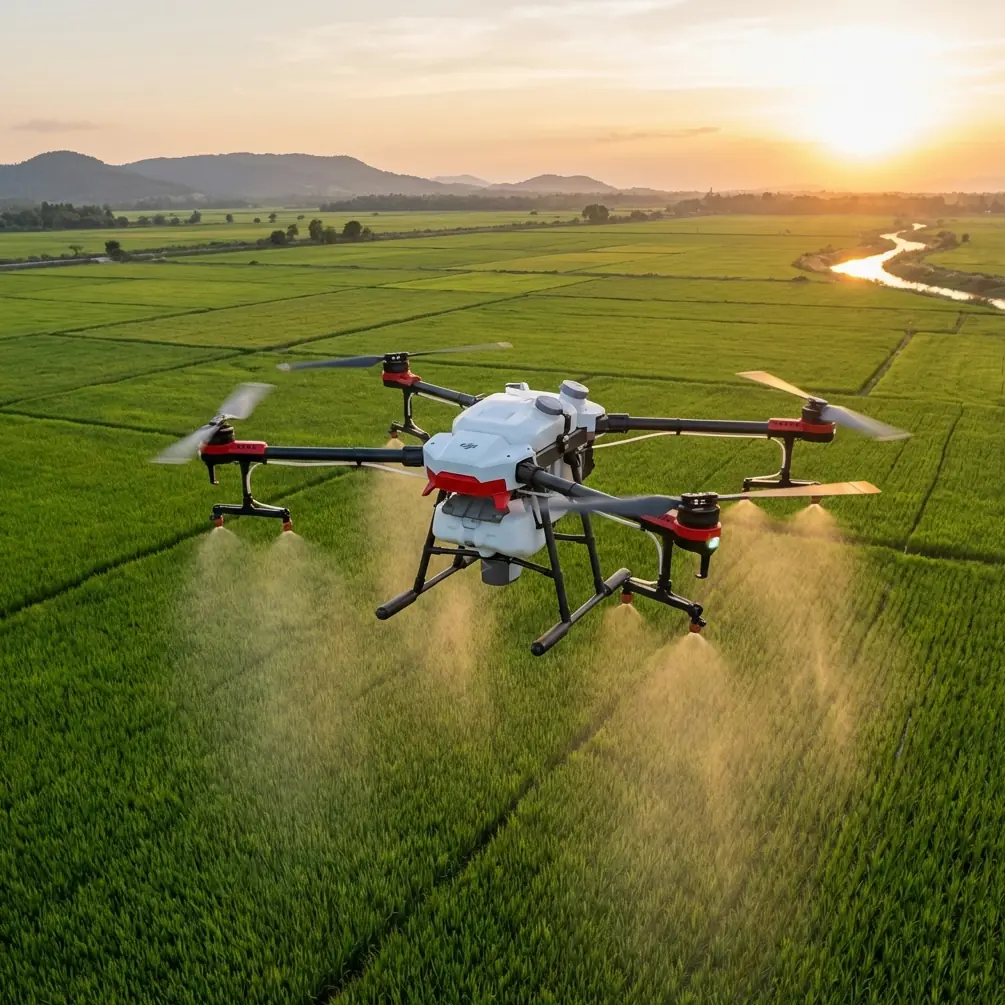
Agras T50 Inspecting Fields in Low Light: A Practical Tutorial for Cleaner Data and Safer Flights
META: Expert tutorial on using the Agras T50 for low-light field inspection, covering obstacle sensing logic, RTK stability, nozzle prep, antenna adjustment, and mapping-aware flight habits.
Low-light field inspection sounds simple until the field stops behaving like a clean daytime test environment. Edges blur. Tree lines flatten into silhouettes. Power infrastructure starts to interfere with positioning. Moisture builds on surfaces. The pilot has less visual confirmation, so the aircraft’s sensing, positioning, and preplanned discipline carry more of the workload.
That is where the Agras T50 deserves a more careful discussion than the usual feature rundown.
If your goal is to inspect fields before or after treatment, verify crop conditions, confirm swath coverage logic, or catch issues that can affect spray drift and nozzle calibration, the T50 can be a very effective platform. But low light changes how you should think about the mission. You are no longer relying mainly on your eyes. You are relying on systems, geometry, signal quality, and predictable flight behavior.
This tutorial is written from that angle.
Why low-light inspection is a systems problem, not just a visibility problem
Many operators frame low-light work as a camera issue. In practice, the bigger challenge is aircraft behavior near the ground. Agricultural drones spend a lot of time where mistakes become expensive: takeoff, landing, low-altitude transitions, and field-edge maneuvering.
A useful reference from UAV flight training highlights exactly this risk. During autonomous flight, especially at takeoff, landing, and low-altitude operation, drones are more likely to encounter trees, buildings, hills, and other obstacles. The same source explains why time-of-flight sensing matters in these phases: the aircraft emits infrared light, measures the return time, and estimates distance from that delay. In plain terms, the drone is calculating how far away something is based on the travel time of light. That principle becomes more than textbook material in low light. It becomes one of the foundations of safe field inspection.
The training material also uses repetitive circular tasks, including 5-circle and 9-circle flight exercises, to teach orientation control and consistent path execution. That matters more than it first appears. Low-light field inspection rewards the same skills: maintaining a repeatable track, controlling aircraft heading deliberately, and understanding whether the aircraft should face the direction of travel or hold another orientation through a turn.
For an Agras T50 operator, this means one thing: the mission should be built around stable geometry and sensor confidence, not improvisation.
Start with the inspection objective, not the aircraft mode
Before you power up, define what you are trying to confirm:
- standing water or drainage issues
- lodging or emergence gaps
- treatment misses along turns or field borders
- likely drift zones around tree lines or structures
- access routes for the next spray job
- crop variability that may justify a closer multispectral follow-up
Notice what is not on that list: “fly around and look.” That approach wastes battery, increases exposure to low-light obstacles, and often produces weak notes that cannot be acted on later.
I suggest dividing low-light inspections into three mission types:
1. Boundary confirmation
You are checking field limits, obstacles, poles, irrigation hardware, and buffer areas.
2. Surface and canopy scan
You are looking for visible irregularities in crop texture, color blocks, wheel tracks, puddling, or patchiness.
3. Application-readiness check
You are evaluating whether the field is ready for a spray mission by reviewing terrain consistency, canopy access, likely drift corridors, and whether your nozzle setup and swath assumptions still make sense.
Each mission type should influence altitude, heading, speed, and how aggressively you trust automation.
Use predictable patterns: why circles still teach the right lesson
One of the better habits from structured drone training is repeated orbit work. The educational source describes a counterclockwise circular flight for 5 laps, stopping automatically, and another version where the aircraft faces the center while moving laterally. It also describes 9 laps with real-time lap display and a light signal marking each completed circuit.
You do not need to reproduce those exercises literally in a field. But the operational lesson is excellent for the T50 in low light.
Predictable repeated paths reveal problems quickly:
- drifting GPS line
- poor heading hold
- asymmetrical response in crosswind
- uneven altitude stability
- unstable RTK Fix rate near infrastructure
- operator disorientation when the aircraft changes heading relative to travel
If the T50 cannot hold a neat orbit or repeatable edge pass before you enter the crop interior, that is your warning. Something in the system stack needs attention. It may be signal quality. It may be antenna orientation. It may be local electromagnetic interference. Or the field margin may simply be too cluttered for the chosen flight line.
A short perimeter rehearsal pass at low-risk altitude tells you more than a long mission started too early.
Handling electromagnetic interference: antenna adjustment is not a minor detail
Low-light work often begins or ends near service roads, pump stations, electrical lines, or sheds with metal roofs. These are exactly the places where positioning confidence can degrade. When operators complain that the aircraft “felt vague,” the root cause is often not pilot skill. It is poor signal discipline.
If your RTK Fix rate begins fluctuating near one side of the field, do not immediately blame the drone. First inspect the environment and your antenna setup.
Here is the practical sequence I recommend:
Stop and observe the pattern
Does the issue happen only near power lines, steel structures, or parked machinery? If yes, think interference first.Adjust antenna orientation deliberately
Small changes matter. Re-angle the controller or external antenna so the signal path is cleaner and less shadowed by your body, vehicle, or nearby structures.Change your standing position
Move several meters away from metal objects or electrical equipment before rechecking satellite and RTK behavior.Verify whether the fix recovers before continuing
Low-light is not the time to “push through” a marginal fix. Centimeter precision is only useful when it is actually stable.Rehearse a short straight pass
If the path still wanders or heading corrections look uneven, revise the mission line or postpone detailed inspection in that section.
This is where the T50’s precision workflow lives or dies. On paper, centimeter precision sounds like a headline feature. In the field, it is a conditional advantage. It depends on signal integrity. Low light reduces your ability to visually cross-check the aircraft’s exact relationship to rows, edges, and obstacles, so degraded RTK performance becomes more consequential, not less.
Respect obstacle sensing, but do not turn it into blind trust
The educational reference on TOF sensing is valuable because it describes the principle clearly: infrared emission, reflected return, timed delay, distance calculation. It also points out where obstacle risk is highest: low-altitude operations, takeoff, and landing.
That maps neatly onto how the Agras T50 should be used around dusk, dawn, or under heavy cloud.
A few practical rules:
Keep the first climb conservative
The most dangerous seconds of a low-light mission are often the first twenty. Dust, irrigation pipes, edge vegetation, and partial visual ambiguity all stack up there.
Inspect field entrances and staging spots in daylight if possible
A drone can only avoid what its sensors and logic can confidently interpret. Tall grass, fence wire, and irregular edge clutter are poor candidates for casual setup in dim conditions.
Do not use obstacle sensing as a substitute for route design
A well-planned path should reduce the number of avoidance decisions the aircraft has to make.
Watch for terrain transitions
Ditches, embankments, and terraces change the geometry quickly. In low light, those changes are harder for the operator to judge by sight, so altitude discipline matters.
The lesson from TOF is not that the aircraft sees everything perfectly. It is that sensor-based distance awareness is most valuable when you have already chosen a conservative path.
Inspection settings that actually affect agronomic decisions
Field inspection is useful only if it improves the next decision. For T50 users, that usually means improving application quality.
Spray drift assessment
Low light often coincides with calmer conditions, but not always. Tree lines and embankments can produce uneven local air movement that is easy to miss from the ground. During your inspection, note sections where airflow may funnel or curl. These are the sections where drift risk can become less predictable, even when general wind readings look acceptable.
Nozzle calibration checks
An inspection mission can reveal whether your planned droplet distribution and coverage assumptions still fit the crop stage. If the canopy has thickened, if row closure is uneven, or if wheel tracks suggest restricted access and altered pass geometry, revisit nozzle calibration before the next operation.
Swath width verification
Do not assume the theoretical swath width remains the operational swath width in every field block. Margins, irregular planting, terraces, and edge obstacles can force narrower effective coverage. A twilight reconnaissance pass often exposes where your clean map lines will break down in reality.
Multispectral follow-up decisions
The T50 inspection may show enough visible inconsistency to justify a more analytical survey with a dedicated multispectral workflow. That is often the smarter sequence: use the T50 to identify where the field deserves higher-resolution agronomic diagnosis instead of trying to treat the whole property as equally uncertain.
Weather, moisture, and hardware discipline
Agricultural work rarely waits for ideal surfaces. Moisture, residue, and washdown realities are part of the job. That is where ruggedness matters, and where an aircraft built for hard field use earns its keep. If your T50 is operating around wet staging areas or after cleanup cycles, an IPX6K-class protection mindset is relevant because contamination control is not separate from reliability. Mud on landing gear, moisture near connectors, and residue buildup around critical surfaces all affect confidence during inspection and later application work.
Still, sealed hardware is not permission to get sloppy.
Low-light flights deserve a stricter routine:
- wipe lenses and sensing areas before launch
- inspect antennas and mounts for looseness
- confirm tank area and frame surfaces are clean enough not to mislead visual checks
- verify controller brightness and alert settings
- review battery condition with no shortcuts
One neglected lens can downgrade the entire mission.
A simple low-light field inspection workflow for the T50
Here is the field method I teach teams when consistency matters more than speed.
Step 1: Daylight prep
Walk or drive the field edge earlier if possible. Identify wires, branches, poles, pumps, and terrain breaks.
Step 2: Positioning check
Power up away from obvious metal clutter. Confirm satellite quality and RTK behavior before moving to the launch point.
Step 3: Antenna adjustment
If the fix rate is unstable, change antenna orientation first. Then change your standing position. Do not normalize interference.
Step 4: Short rehearsal line
Fly one controlled perimeter segment or a compact orbit. Think of this as your live systems check. The training logic behind 5-lap and 9-lap pattern drills is useful here: repeatability tells the truth.
Step 5: Primary scan
Fly the field with a defined purpose: boundaries, canopy, or application readiness. Record observations section by section.
Step 6: Agronomic interpretation
Translate what you saw into action:
- adjust nozzle calibration
- revise swath width assumptions
- flag drift-sensitive edges
- mark suspect areas for multispectral follow-up
- delay application if terrain moisture or visibility introduces too much uncertainty
Step 7: Debrief immediately
Do not trust memory after dark. Write the notes while the image is still fresh.
If your team needs a second opinion on setup logic or field workflow, you can message a T50 operations specialist here: https://wa.me/85255379740.
The bigger point: low-light inspection should make the next mission more precise
A well-run T50 inspection flight does not just produce observations. It reduces uncertainty.
That reduction comes from disciplined path design, signal awareness, obstacle-sensing respect, and agronomic interpretation. The educational flight reference may seem far removed from a commercial agricultural platform, yet its lessons are surprisingly direct: repeated circular paths teach control consistency; real-time counting reinforces predictable execution; and TOF sensing reminds us that low-altitude autonomy depends on measured distance, not guesswork.
There is also a broader connection to mapping practice. Low-altitude UAV remote sensing has long been recognized in surveying applications because flying lower can improve detail and local relevance when the mission is properly structured. For agriculture, that same principle means inspection is most useful when the flight plan is tailored to the field problem rather than treated like a casual overview.
The Agras T50 is at its best when used with that mindset. In low light, the aircraft should not be asked to compensate for vague planning. It should be used as a precise platform inside a disciplined workflow.
That is how you get cleaner observations, safer margins, and better decisions before the next spray pass.
Ready for your own Agras T50? Contact our team for expert consultation.