Agras T50 Field Inspection at High Altitude
Agras T50 Field Inspection at High Altitude: A Practical Tutorial Built from What the Drone Industry Is Signaling
META: A field-focused Agras T50 tutorial for high-altitude crop inspection, covering spray drift, nozzle calibration, RTK fix rate, swath width, multispectral add-ons, and why major drone industry events matter for real operators.
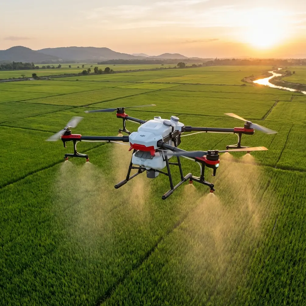
High-altitude farming exposes every weakness in a drone workflow. Wind behaves differently. GNSS stability can fluctuate against steep terrain. Crop vigor often changes from one contour line to the next. That is why field inspection with the Agras T50 should not be treated as a routine pre-spray checkbox. In mountain orchards, terrace fields, and elevated broadacre plots, inspection is the mission that determines whether the rest of the operation works cleanly or wastes time, chemical, and battery cycles.
This is the lens I would use as an academic and field-oriented operator: not “what can the T50 do” in the abstract, but how a serious team should inspect with it when altitude and terrain begin to magnify small mistakes.
There is another reason this matters now. At the Ninth World Drone Congress, more than 5,000 products were exhibited, all centered on the drone sector and its associated technologies. That number matters operationally. When an industry event gathers over 5,000 products around one ecosystem, it signals something bigger than product variety. It tells operators that drone workflows are no longer defined by a single airframe. Real capability now lives in the stack: aircraft, positioning, sensors, payload behavior, software, and accessories. For an Agras T50 user inspecting fields at elevation, that means better decisions come from system design, not from the drone alone.
Why high-altitude inspection deserves its own method
Agras T50 operators often focus on payload, route efficiency, and application output. Those are downstream metrics. Upstream, inspection is where mission quality is won or lost.
At higher elevations, three variables usually become less forgiving:
Wind and spray drift risk increase in complexity
Air can channel unpredictably along ridges and terraces. A low valley crosswind at launch may become a side slope gust at the treatment block. Inspection needs to map that behavior, not assume stability.RTK reliability becomes more than a convenience
In flat open fields, a marginal RTK Fix rate may go unnoticed until overlap quality degrades. In elevated and broken terrain, centimeter precision directly affects line keeping, edge treatment, and obstacle confidence.Crop variability becomes spatially sharper
Altitude, slope, sun exposure, and drainage create micro-zones. A field that looks uniform from the road may contain several management zones once viewed properly.
That is why the T50, in this context, should be treated as part of an inspection system rather than a simple application platform.
Start with a terrain-first inspection model
Before discussing sensors or settings, begin with terrain logic. On high-altitude farmland, divide the site into four practical layers:
- Access layer: launch area, battery swap point, safe recovery paths
- Topographic layer: ridges, terraces, drainage cuts, sudden elevation breaks
- Crop layer: canopy density, stress patterns, stand gaps, lodging or uneven growth
- Atmospheric layer: wind corridors, turbulence pockets, temperature shifts during the mission window
This structure matters because inspection data becomes useful only when tied to action. If you identify a stressed block but fail to connect it to a downslope wind corridor, your next spray plan may still drift. If you map the slope but ignore variable stand density, your swath width assumptions may remain too optimistic.
The T50 operator who performs well at altitude is usually the one who interprets the field as a living system rather than a blank polygon on a tablet.
The first checkpoint: RTK fix rate and centimeter precision
The LSI hint of RTK Fix rate is not just technical jargon. It is one of the most practical indicators of whether your inspection and later treatment routes will hold shape.
In elevated terrain, a weak or inconsistent fix can lead to subtle path distortion. That distortion shows up as:
- uneven overlap
- edge miss on irregular field boundaries
- unnecessary correction maneuvers
- reduced confidence near trees, poles, or terrace walls
Centimeter precision matters here because high-altitude inspection is often about identifying narrow treatment decisions. A few decimeters of positional inconsistency may not sound dramatic in an office conversation, but in a stepped field or orchard row it can be the difference between a clean pass and an avoidable revisit.
My recommendation is straightforward: during the inspection stage, do not merely confirm that RTK is active. Watch for fix stability across the whole block, especially near elevation changes and edges. If the fix degrades in specific segments, mark those zones as operationally sensitive. That note will be more valuable than a generic “RTK available” status.
Spray drift begins during inspection, not application
Many teams discuss spray drift only after nozzle settings are chosen. That is too late.
Inspection should be used to identify where drift is most likely to occur and why. At altitude, drift pressure is driven by more than wind speed. Slope orientation, canopy gaps, temperature shifts, and lateral airflow along terraces all matter.
Here is a practical inspection sequence:
1. Fly the perimeter first
The field edge often tells the real story. Observe exposed corners, open downhill sides, and windward boundaries. These are the places where droplets are most likely to move off target later.
2. Compare upper and lower sections
The top of the field may experience very different airflow than a lower terrace or protected basin. If the crop condition differs sharply between these sections, resist using one treatment assumption for all of it.
3. Watch vegetation movement
Nearby trees, border grass, or cover crop movement can reveal airflow direction more honestly than a single handheld reading.
4. Flag drift-sensitive edges
If one boundary is adjacent to a road, water feature, greenhouse, or neighboring crop, note it during inspection and adapt route direction and droplet strategy later.
The significance is simple: inspection should produce a drift map, even if informal. Without that, the best aircraft settings still rely too heavily on hope.
Nozzle calibration is only meaningful if tied to canopy reality
Nozzle calibration is often treated as a maintenance task. In high-altitude agriculture, it should be treated as a crop-response task.
Agras T50 users inspecting elevated fields need to connect calibration to what the canopy actually looks like on the day of operation. If the inspection reveals:
- patchy vigor,
- thinner canopy on upper exposed slopes,
- denser growth in lower moisture-retaining areas,
- or stress patterns linked to altitude and exposure,
then a one-size calibration mindset becomes weak.
Calibration matters operationally because droplet behavior interacts with canopy structure. A dense section may tolerate and require a different deposition profile than a sparse, wind-exposed section. Inspection is what tells you whether your existing calibration assumptions still match the field.
The practical takeaway: do not calibrate in isolation at the staging area and assume the field conforms. Inspect first, then validate whether nozzle output and route design still align with actual crop architecture.
Swath width should be earned, not assumed
One of the easiest ways to lose quality in a mountain or highland operation is to overestimate swath width.
Manufacturers and operators naturally work with target width ranges, but at altitude the field itself should confirm what is realistic. Slope angle, canopy height variation, and crosswind behavior can all reduce the effective width of a clean, consistent pass.
When inspecting with the T50, use visible crop variability and terrain interruptions to decide whether nominal swath assumptions are too optimistic. If the field includes narrow terraces, irregular orchard geometry, or abrupt elevation transitions, reducing swath width slightly may improve uniformity enough to offset the extra flight time.
That tradeoff is often worth it. A narrower, controlled pattern usually beats a wide pattern that leaves patchiness and forces rework.
Where multispectral adds real value
The context suggests multispectral as a relevant capability, and this is exactly where the broader drone ecosystem becomes useful. Remember the signal from the Ninth World Drone Congress: over 5,000 products were displayed in an event focused on drone technology and industry. For T50 operators, that scale points to a mature accessory environment. The smartest inspection workflows increasingly combine the spray platform with specialized third-party tools.
A practical example is adding a third-party multispectral mapping payload or companion survey drone workflow before T50 operations. The T50 itself is built around agricultural work, but a separate multispectral capture step can sharpen your understanding of high-altitude variability far beyond visual inspection.
Why this matters:
- It reveals stress patterns that are hard to see from ground level.
- It helps separate wind exposure effects from nutrient or irrigation issues.
- It supports zone-based planning instead of treating the field as uniform.
In elevated fields, this is particularly useful because microclimates can shift over surprisingly short distances. A multispectral pass can show that a sun-exposed upper bench and a shaded lower bench are behaving like different fields.
That is the operational significance of the wider product ecosystem on display at a major drone congress. It is not just market noise. It is evidence that T50 users now have practical ways to build better inspection stacks around the aircraft.
Why accessory choice matters more than people admit
The narrative spark here was to mention a third-party accessory that enhanced capability. In my view, one of the most defensible examples is a rugged third-party RTK base station or survey-grade positioning kit integrated into the broader workflow.
On high-altitude sites, especially where terrain complicates signal behavior, a stronger positioning setup can improve route confidence and repeatability. That directly supports:
- more consistent edge handling,
- better confidence in narrow terraces,
- stronger correlation between inspection findings and treatment execution.
Another useful accessory class is weather instrumentation mounted at the staging area, especially a compact wind and microclimate station. This is less glamorous than a new sensor, but often more valuable. High-altitude work punishes assumptions. Real wind trend data over the mission window gives inspection findings context.
If you are building out this kind of workflow and want a technical conversation rather than generic product talk, I would point teams to this field setup discussion channel where implementation questions can be sorted quickly.
Don’t ignore enclosure durability in dirty field conditions
The term IPX6K deserves a place in the inspection conversation, even though people often reserve it for spec sheets. In high-altitude agriculture, the drone is not operating in a clean laboratory. Dust, splash, residue, and repeated field handling are part of the job.
Protection ratings matter because inspection is frequently done under less-than-ideal conditions: damp mornings, muddy launch points, residue on equipment, and rapid transitions between scouting and treatment. A robust enclosure standard supports uptime and reduces the chance that ordinary field exposure becomes an operational interruption.
The key point is not the label itself. The point is reliability under real agricultural abuse. For teams operating far from easy support access, especially in upland or remote areas, durability directly supports mission continuity.
A practical high-altitude inspection workflow for the Agras T50
Here is the tutorial version I would recommend.
Step 1: Establish a stable launch and observation point
Choose a location with clear sky visibility, safe takeoff margin, and room for battery handling. Do not let convenience force a poor launch geometry.
Step 2: Confirm positioning quality early
Check RTK behavior before committing to a full route. Watch whether fix stability changes as the aircraft approaches terrain breaks or field edges.
Step 3: Run a visual terrain scan
Look for wind channels, terraces, trees, utility obstacles, and uneven crop zones. Mark anything that could affect line quality or droplet placement later.
Step 4: Compare canopy behavior by elevation band
Upper slope, mid-slope, and lower sections often behave differently. Inspect each as a separate management zone unless proven otherwise.
Step 5: Evaluate drift risk boundaries
Do not just inspect the crop interior. Study exposed edges where airflow may pull droplets away from target areas.
Step 6: Decide whether nominal swath width is realistic
If terrain, geometry, or canopy inconsistency suggests reduced uniformity, tighten the plan before application begins.
Step 7: Match nozzle calibration to field condition
Use inspection findings to confirm whether your planned output still fits canopy density and crop health variation.
Step 8: Add multispectral or companion mapping where variability is unclear
If visual inspection leaves unanswered questions, bring in a third-party sensor workflow rather than guessing.
Step 9: Reassess conditions before treatment
High-altitude weather can shift quickly. What was acceptable 30 minutes ago may no longer be acceptable.
What the industry event really tells Agras T50 operators
The most interesting fact in the reference material is not just that the Ninth World Drone Congress featured over 5,000 products. It is what that means for the operator standing in a real field.
A drone-centered industry event of that scale shows that the commercial UAV sector has moved beyond isolated hardware decisions. Inspection quality now depends on how well operators combine aircraft capability with positioning tools, sensing options, data interpretation, and mission discipline.
For Agras T50 users, especially in high-altitude agriculture, this is good news. The platform does not need to do everything alone. The market around it is increasingly capable of filling the gaps with better accessories, better data tools, and better workflow design.
That is the real professional shift. Not hype. Not trend language. Just a more mature operating environment where inspection can be treated with the seriousness it deserves.
And in high-altitude work, that seriousness pays off quickly. Better RTK integrity. Better control of spray drift. Better nozzle decisions. More realistic swath width. More informed use of multispectral data. Fewer assumptions. Fewer repeat flights.
That is how the Agras T50 becomes more effective: not by flying harder, but by inspecting smarter.
Ready for your own Agras T50? Contact our team for expert consultation.