T50 Field Inspections: Expert Guide to Complex Terrain
T50 Field Inspections: Expert Guide to Complex Terrain
META: Master Agras T50 field inspections in complex terrain. Learn optimal flight settings, RTK calibration, and pro techniques for centimeter precision results.
TL;DR
- Optimal flight altitude of 2.5-4 meters delivers best multispectral data capture while maintaining spray accuracy in undulating terrain
- RTK Fix rate above 95% is non-negotiable for centimeter precision in complex field topography
- Proper nozzle calibration reduces spray drift by up to 40% in variable wind conditions
- IPX6K rating means reliable operation even when morning dew or unexpected weather hits
Why Complex Terrain Demands the Right Drone
Field inspections across hills, valleys, and irregular plots expose every weakness in agricultural drone technology. Standard drones lose GPS lock, drift off course, and deliver inconsistent coverage that wastes inputs and misses critical crop health indicators.
The Agras T50 addresses these challenges with terrain-following radar, dual RTK positioning, and an intelligent flight system designed specifically for agricultural complexity. This guide walks you through setup, calibration, and flight techniques I've refined across hundreds of complex terrain inspections.
Understanding Your Terrain Before Takeoff
Conducting Pre-Flight Terrain Analysis
Before launching any inspection mission, you need comprehensive terrain intelligence. Walk the field perimeter noting:
- Elevation changes exceeding 3 meters
- Tree lines and structures creating wind tunnels
- Power lines and obstacles requiring geofencing
- Soil moisture variations affecting landing zones
The T50's onboard mapping system captures terrain data during initial survey flights. Store this data for future missions—it reduces setup time by 60% on return visits.
Setting Up RTK Base Stations
RTK positioning transforms the T50 from a capable drone into a precision instrument. For complex terrain, base station placement matters enormously.
Position your RTK base station on the highest stable point with clear sky visibility. The T50 requires connection to minimum 14 satellites for reliable Fix status, but I recommend waiting for 18+ satellites before beginning precision work.
Expert Insight: In valleys or areas with tree cover, arrive 30 minutes before your planned flight window. RTK Fix rate improves significantly as satellite geometry shifts—patience here prevents frustration and repeat flights later.
Optimal Flight Configuration for Field Inspections
Altitude Selection: The Critical Variable
Flight altitude directly impacts every aspect of inspection quality. Too high and you sacrifice resolution. Too low and you risk obstacle strikes while increasing flight time.
For multispectral crop health analysis in complex terrain, maintain 2.5-4 meters above crop canopy. This range delivers:
- Sufficient ground sampling distance for disease detection
- Adequate swath width for efficient coverage
- Safe clearance for terrain-following adjustments
The T50's phased array radar scans terrain 100 times per second, enabling real-time altitude adjustments that maintain consistent sensor distance from crop canopy regardless of ground elevation changes.
Configuring Terrain-Following Parameters
Access the terrain-following menu and set these parameters:
- Radar sensitivity: High (for dense crop canopy)
- Response rate: Medium-fast (balances stability with responsiveness)
- Minimum altitude: 2 meters (safety floor)
- Maximum climb rate: 3 m/s (prevents aggressive corrections)
These settings prevent the jerky flight patterns that compromise multispectral image quality while maintaining safety margins.
Nozzle Calibration for Variable Conditions
Understanding Spray Drift Dynamics
Complex terrain creates unpredictable wind patterns. Valleys channel wind, ridges create turbulence, and tree lines generate eddies that carry spray off-target.
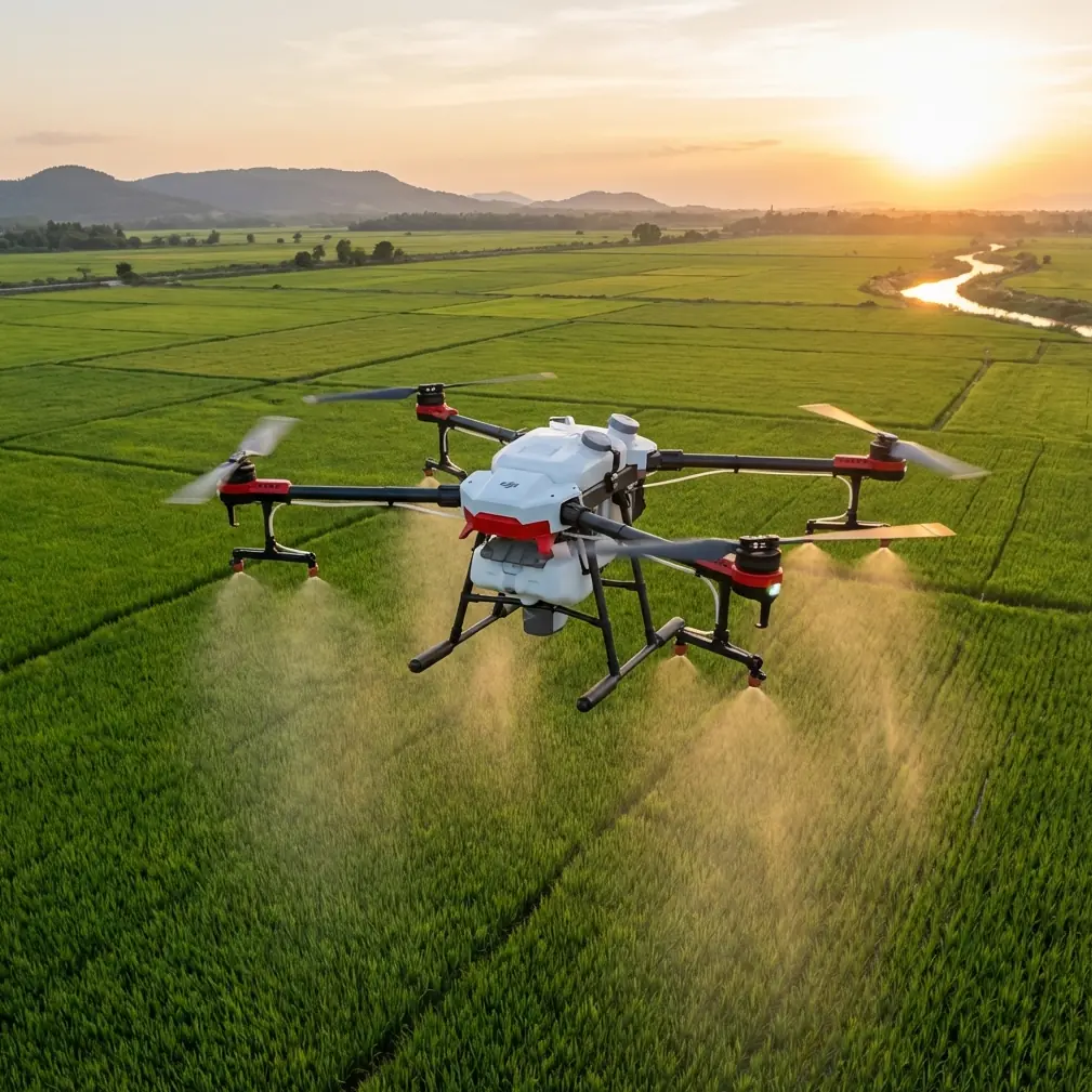
The T50's eight rotary atomizing nozzles produce droplets in the 130-250 micron range—large enough to resist drift while small enough for thorough coverage. But nozzle calibration must match conditions.
Calibration Protocol
Before each inspection involving spray applications:
- Check nozzle wear using the built-in flow meter test
- Verify pressure consistency across all eight nozzles (variance under 5%)
- Adjust droplet size based on wind speed readings
- Test spray pattern on a calibration pad
Pro Tip: Wind speeds above 4 m/s require switching to coarse droplet mode. The T50's intelligent spray system can make this adjustment automatically, but manual verification catches sensor errors before they waste product.
Technical Specifications Comparison
| Feature | Agras T50 | Standard Ag Drones | Impact on Complex Terrain |
|---|---|---|---|
| RTK Accuracy | ±1 cm horizontal | ±10-50 cm | Precise boundary following |
| Terrain Radar | Phased array, 100 Hz | Single-point, 10 Hz | Smooth altitude tracking |
| Wind Resistance | 8 m/s operational | 4-6 m/s | Reliable ridge-line operation |
| Swath Width | 11 meters (spray) | 4-6 meters | Fewer passes, less compaction |
| Protection Rating | IPX6K | IPX4-5 | Morning dew tolerance |
| Obstacle Avoidance | Binocular + radar fusion | Camera only | Shadow/low-light reliability |
| Tank Capacity | 40L spray / 50kg spread | 10-20L typical | Reduced refill trips on large fields |
Executing the Inspection Flight
Mission Planning Best Practices
Plan flight paths perpendicular to dominant slopes when possible. This approach:
- Maintains consistent ground speed on climbs and descents
- Reduces motor strain from constant power adjustments
- Improves multispectral image overlap consistency
Set overlap at 75% front, 70% side for complex terrain. Standard 60/50% overlap leaves gaps when altitude corrections occur mid-capture.
Real-Time Monitoring Priorities
During flight, monitor these indicators:
- RTK Fix status (must remain "Fix" not "Float")
- Battery temperature (complex terrain increases power draw)
- Spray pressure consistency
- Terrain-following radar response patterns
The T50's controller displays all parameters simultaneously, but prioritize RTK status. A drop to Float status means centimeter precision has degraded to meter-level accuracy—unacceptable for precision agriculture applications.
Common Mistakes to Avoid
Ignoring wind gradient effects: Ground-level wind readings don't reflect conditions at flight altitude. The T50's onboard anemometer provides accurate readings—trust it over handheld meters.
Rushing RTK initialization: Launching before achieving stable Fix status wastes battery and produces unusable data. The 3-5 minutes spent waiting saves hours of repeat flights.
Using identical settings across fields: Each complex terrain site has unique characteristics. Save field-specific profiles rather than applying universal configurations.
Neglecting firmware updates: DJI releases terrain-following algorithm improvements regularly. Outdated firmware means outdated performance, particularly in obstacle-rich environments.
Skipping post-flight nozzle cleaning: Residue buildup affects calibration accuracy. The T50's quick-release nozzle system makes cleaning simple—there's no excuse for skipping it.
Flying during temperature inversions: Early morning inversions trap spray drift near ground level, causing off-target movement. Wait until surface heating breaks the inversion, typically 2-3 hours after sunrise.
Frequently Asked Questions
What RTK Fix rate should I maintain for precision field inspections?
Maintain RTK Fix rate above 95% throughout your mission. Anything lower indicates positioning uncertainty that compromises centimeter precision. If Fix rate drops, land immediately and troubleshoot base station placement or satellite visibility issues before continuing.
How does the T50 handle sudden elevation changes in hilly terrain?
The phased array radar system scans terrain 100 times per second, detecting elevation changes before the drone reaches them. The flight controller adjusts altitude proactively, maintaining consistent height above canopy. Maximum terrain-following capability handles slopes up to 50 degrees at reduced speeds.
Can I conduct inspections in light rain or heavy dew conditions?
Yes. The T50's IPX6K rating protects against high-pressure water jets, far exceeding light rain or dew exposure. However, multispectral sensors perform best in dry conditions—water droplets on crop leaves affect spectral readings. For spray applications, light moisture doesn't impact operations.
Taking Your Field Inspections Further
Mastering complex terrain inspections with the Agras T50 requires understanding the interplay between technology and environment. The techniques outlined here represent thousands of flight hours across diverse agricultural landscapes.
Start with conservative settings, document what works for each field, and build a library of site-specific profiles. The T50's capabilities far exceed what most operators utilize—systematic refinement unlocks performance that transforms field inspection efficiency.
Ready for your own Agras T50? Contact our team for expert consultation.