Agras T50 for Dusty Construction Sites: A Practical Field
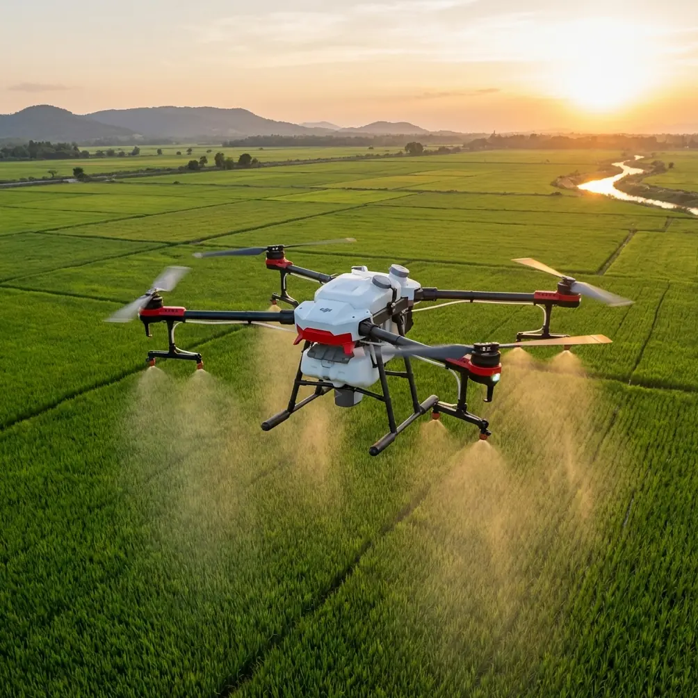
Agras T50 for Dusty Construction Sites: A Practical Field Guide from an Ag Drone Perspective
META: Learn how the DJI Agras T50 can be adapted for dusty construction-site inspection workflows, with field-focused guidance on payload logic, transmission reliability, portability, mapping outputs, and operational constraints.
Construction teams usually don’t look at an agricultural drone first when they need site intelligence. They think of survey quadcopters, photogrammetry rigs, or compact inspection platforms. That instinct makes sense. But on harsh, dusty sites where payload resilience, stable low-altitude work, and fast redeployment matter more than sleek form factor, the Agras T50 deserves a harder look.
That does not mean treating it like a conventional mapping drone. It means understanding where its architecture helps, where it does not, and how to build a workflow around those realities.
I approach this from a UAV systems perspective, not from marketing literature. The useful question is simple: if you are evaluating the Agras T50 for construction inspection in dusty conditions, what actually matters in the field?
Start with the environment, not the aircraft brochure
Dust changes everything.
On active construction sites, airborne particulates reduce contrast, contaminate exposed components, interfere with visibility, and create a steady maintenance burden. Add uneven ground, improvised takeoff zones, and moving machinery, and the drone is no longer operating in the clean assumptions of a demo video.
This is where the T50 enters the conversation. The model is known primarily for agricultural work, but agriculture and construction share one punishing trait: they are outdoor, debris-heavy, logistics-sensitive environments. A drone built for repetitive low-altitude work over fields is not automatically ideal for construction inspection, yet it may be better suited to dust, field deployment, and rugged handling than lighter imaging platforms designed around cleaner survey workflows.
That distinction matters. A construction manager evaluating the T50 should not ask, “Is this the best mapping drone?” The sharper question is, “Can this platform sustain useful inspection output in a dirty, operationally messy setting where smaller systems may lose efficiency?”
Why portability still matters on large job sites
A lot of drone selection mistakes happen before first flight. Teams focus on the airframe in isolation and forget the carrying system, batteries, controller, and deployment friction.
One of the reference solutions for small-area crop investigation makes a point that remains highly relevant to construction work: light rotary UAVs are favored when the collection area is limited, because they are easy to carry, flexible in low-altitude flight, stable, and demand very little from the launch and recovery area. That same document gives a practical benchmark: a field kit including the aircraft, backpack, batteries, and controller can come in at about 5 kilograms for a compact solution.
The T50 is obviously not a 5-kilogram backpack-class platform. That is exactly why this benchmark matters.
If your inspection task involves climbing embankments, moving across partially developed roads, or hopping between isolated work fronts, then compact systems still hold a mobility advantage. For small orthomosaic tasks or quick visual checks, a lighter aircraft remains easier to stage. The cited crop-survey document also notes that a 23-minute theoretical flight time on a smaller platform can be enough to capture one sampling block, and that 12 MP imagery from 100 meters can produce roughly 5 cm orthomosaic resolution. For certain construction deliverables, that is already sufficient.
So where does that leave the T50?
It means the T50 should be chosen when the site conditions reward robustness and work continuity more than ultra-light portability. If your inspection day involves blowing dust, repeated relocations by vehicle, and heavy use over broad work zones rather than hand-carried hillside access, the T50’s larger-format operating logic begins to make sense. If the mission is a quick walk-in mapping run over a compact site corner, it may be more drone than you need.
Transmission reliability is not a luxury on dusty sites
Construction inspection often fails in a boring way: not through a crash, but through weak operational visibility. Dust reduces visual confidence. Equipment clutter causes interference. Operators relocate constantly. Under those conditions, the downlink becomes part of safety and part of productivity.
One emergency mapping reference in the source material describes an HD digital transmission system capable of 1920×1080 at 60P/50P, with a quoted 5 km transmission distance at 100 m, and a ground station using dual-antenna redundant reception. It also lists 500 ms end-to-end latency and emphasizes strong-light screen visibility.
Those are not T50 specs, but they illustrate what a serious industrial workflow expects from a field video link. On a dusty construction site, this translates into a few operational truths:
- Resolution matters for judgment. Fine dust often hides edge conditions. You need enough image quality to distinguish loose aggregate, exposed steel, spoil boundaries, and temporary access hazards.
- Latency matters for close maneuvering. Half-second delay may be manageable for broad observation, but operators should be aware that any lag compounds risk near structures, cables, and elevated materials.
- Display brightness matters more than many buyers expect. Harsh daylight and airborne dust can wash out weak screens quickly.
- Redundancy is not overkill. A dual-antenna mindset reflects the real-world need for stable reception when the drone’s orientation changes or site obstacles interrupt the line of sight.
For T50 users, the takeaway is not to chase spec-sheet theater. It is to validate whether your command-and-control and image transmission setup stays dependable when the site gets bright, dusty, and noisy. If the aircraft remains airborne but the video workflow degrades, the inspection value drops sharply.
The T50 is not just about endurance. It is about operational tolerance
Many people compare aircraft by flight time alone. That is too shallow for industrial work.
The crop-survey source is useful because it shows how mission design is tied to aircraft class. It notes that even under complex interference conditions, a 3.5 km theoretical control range can still support reliable image transmission and control within 1 km, which was enough for sampling missions. That gap between “advertised maximum” and “usable working envelope” is exactly how professionals should evaluate the T50.
Dusty construction operations benefit from aircraft that can hold a stable low-altitude profile, absorb a rougher duty cycle, and remain predictable through repeated sorties. The T50’s appeal is less about chasing maximum distance and more about maintaining a credible working envelope under site stress.
That is where agricultural DNA can help. Spray platforms are built for repetitive route work, environmental contamination, and frequent turnaround. In practical terms, that often aligns better with construction realities than delicate survey drones optimized for lighter payloads and cleaner workflows.
Still, be disciplined. For inspection missions, avoid forcing the T50 into roles where a compact imaging drone is inherently better. Tight facade work, confined underside inspection, or long walk-in deployments over broken terrain may still favor smaller aircraft.
What outputs do construction teams actually need?
Inspection is not one thing. Some teams want live visual confirmation. Others want measurable mapping products. Some need both on the same day.
The emergency mapping reference provides a good benchmark for the data expectations around industrial UAV workflows. It highlights software outputs such as:
- orthomosaics in GeoTIFF
- DEM generation
- densified point clouds
- 3D models in OBJ
- aerial triangulation and block adjustment
- automatic accuracy reporting
This matters because drone selection should be driven by downstream deliverables, not just airborne performance.
If your construction team needs volume checks, surface-progress documentation, haul-road change tracking, or stockpile context for planning meetings, then the drone’s value depends on how reliably the image set can be turned into orthomosaics, DEMs, and point clouds. If your main need is dust-plume observation, drainage path checks after grading, or visual verification of material movement, then live transmission quality may matter more than dense photogrammetric reconstruction.
The T50 can be part of either workflow, but the payload and capture plan need to be aligned with the final output. A rugged platform without disciplined data acquisition will not save a weak mapping process.
A note on dusty optics, nozzle logic, and cross-domain thinking
Because the Agras T50 comes from agriculture, some users instinctively carry over farming language like spray drift, swath width, and nozzle calibration. On a construction site, those terms only make sense if the aircraft is being used for lawful civilian utility tasks adjacent to inspection operations, such as controlled site treatment or dust-management support by authorized teams. For pure inspection missions, the deeper lesson is about calibration discipline.
Agricultural operators survive by respecting consistency. Swath width must be known. Application behavior must be predictable. Settings cannot be guessed. Construction inspection teams should borrow that mindset even when no liquid payload is involved. Camera alignment, route spacing, altitude consistency, overlap, and RTK fix rate all need the same rigor. If a site team is casual about calibration, it will show up later as stitching errors, inconsistent ground sampling distance, and weak comparison between survey dates.
That is one reason the T50 can outperform “lighter competitors” in certain harsh-use scenarios: not because it is magically better at every imaging task, but because the platform encourages an industrial operating culture. It is built around repeated, disciplined field execution rather than occasional ad hoc flights.
When a lighter drone still wins
This is the part buyers often skip.
The same source material that praises small rotary platforms for crop investigation makes a compelling case for compact systems in limited-area collection. Easy transport. Minimal launch requirements. Flexible low-altitude maneuvering. Enough flight time to complete a focused capture block. These are real advantages, and they map directly onto smaller construction tasks.
If your team needs to inspect a single retaining wall, a compact drainage corridor, or a small earthworks segment that requires hiking access, a lighter drone may simply be more efficient. The 5-kilogram all-in field kit cited in the reference is not just a number. It represents a different deployment philosophy: move fast, launch anywhere, collect a small but complete data package, and leave.
The T50 excels when the site is broad enough, dirty enough, and logistically vehicle-centered enough to reward a heavier-duty platform.
A practical deployment checklist for T50 evaluation on construction sites
Before approving the T50 for dusty inspection work, test these points in a controlled pilot program:
1. Define the inspection product
Are you collecting live video, orthomosaics, elevation data, or comparative progress records? The answer determines whether the T50 is properly matched to the mission.
2. Validate real working range
Do not rely on headline range figures. The reference materials show why practical reliability matters more than theoretical maximums. Test your usable site envelope under actual interference and dust conditions.
3. Measure setup friction
How many people are needed? How fast can the team relocate? Is vehicle support assumed? Compare this against the smaller-platform benchmark from the crop-survey reference.
4. Assess image usefulness in bright dust
The emergency mapping reference emphasizes 1080p transmission and sunlight-readable viewing because field visibility is a real constraint. Replicate the worst site lighting you expect.
5. Confirm downstream processing
If your workflow requires GeoTIFF orthomosaics, DEMs, point clouds, or OBJ models, make sure your image acquisition method supports those outputs cleanly.
6. Build a maintenance rhythm
Dust is not a one-off problem. Treat it as an expected operating condition. Lens care, sealing checks, battery hygiene, and connector inspection should be formalized.
Final view: where the Agras T50 fits
The Agras T50 is not the default answer for construction inspection. It is the right answer in a narrower, more demanding set of conditions than many buyers realize.
Choose it when the job site behaves more like an industrial field operation than a delicate survey assignment. Choose it when dust, repeated sorties, rough deployment conditions, and broad-area coverage push lightweight drones out of their comfort zone. Do not choose it merely because bigger sounds tougher.
The source materials behind this discussion point to two durable truths. First, portability and minimal launch requirements remain powerful advantages for small-area capture; the documented 5 kg field kit and 23-minute class of operation still set a useful efficiency benchmark. Second, industrial-grade transmission and mapping workflows depend on practical data reliability, illustrated by benchmarks like 1080p video, 5 km link distance, and structured outputs such as GeoTIFF, DEM, and OBJ products.
A serious T50 evaluation should sit right between those truths: rugged enough for hard sites, disciplined enough for useful data.
If you want help pressure-testing a T50 workflow against your own dust-heavy site conditions, you can reach us directly on WhatsApp for field-planning questions.
Ready for your own Agras T50? Contact our team for expert consultation.