Agras T50 Field Report: What “Endurance” Really Means When
Agras T50 Field Report: What “Endurance” Really Means When Dust, Moisture, and Crop Data Collide
META: A field-style expert report on Agras T50 operations, endurance logic, crop survey workflows, multispectral decision-making, and why raw flight-time numbers can mislead serious agricultural users.
Most people look at a drone spec sheet the wrong way.
They see one number, usually flight time, and turn it into a verdict. Long is good. Short is bad. Simple. But that shortcut falls apart the moment you move from casual aerial imaging into real agricultural work, especially with a platform like the Agras T50.
That is the right lens for this machine.
The Agras T50 is not judged by the same standards as a lightweight camera drone circling a scenic lake in perfect weather. In agriculture, the question is not whether the aircraft can hover beautifully for a few extra minutes on a calm day. The question is whether it can keep producing usable coverage, maintain placement accuracy, and hold operational rhythm when field conditions stop cooperating.
I was reminded of this while reviewing an unrelated but revealing industry anecdote: an engineer experienced in water-environment monitoring saw a waterproof drone listed at “29 minutes+” and immediately thought it sounded a little short because his usual aerial photography drones could fly more than thirty minutes. That reaction is common. It also exposes a bigger misunderstanding. Endurance, by itself, is one of the most abused numbers in commercial UAV decision-making.
For Agras T50 operators, that misunderstanding can be expensive.
Why the Agras T50 should not be judged like an aerial photography drone
An agricultural aircraft works under a different burden profile. It is expected to fly repeatable tracks, hold a usable swath width, deal with payload effects, and preserve application consistency. Even before discussing spray drift, nozzle calibration, or route efficiency, the mission logic is already different from visual-content capture.
Agras T50 buyers often compare it against camera drones because those are familiar. That is the wrong benchmark.
The better comparison is to the crop-survey and precision-ag workflow itself. A 2016 ArcGIS-based crop investigation solution for light UAVs broke the job into four practical stages: image acquisition, production of imagery and interpretation sample points, spatial data management, and industry application. That framework still matters. It reminds us that the aircraft is only one component in a chain that starts with field capture and ends with decisions.
In that document, a small rotary drone is flown along a defined route and altitude to collect high-resolution orthomosaic imagery for later analysis. That one operational detail matters more than it first appears. In agriculture, route discipline beats freestyle flight. The T50’s value is not that it stays in the air as long as possible in a vacuum; its value is that it can repeatedly execute field patterns that support treatment, monitoring, and follow-up analysis with less wasted motion.
That is how professionals should think about endurance: not as a stopwatch, but as acres treated, passes completed, and quality preserved per battery cycle.
A real field mindset: weather changed mid-flight
One of the most revealing moments in the field usually comes when conditions shift halfway through the job.
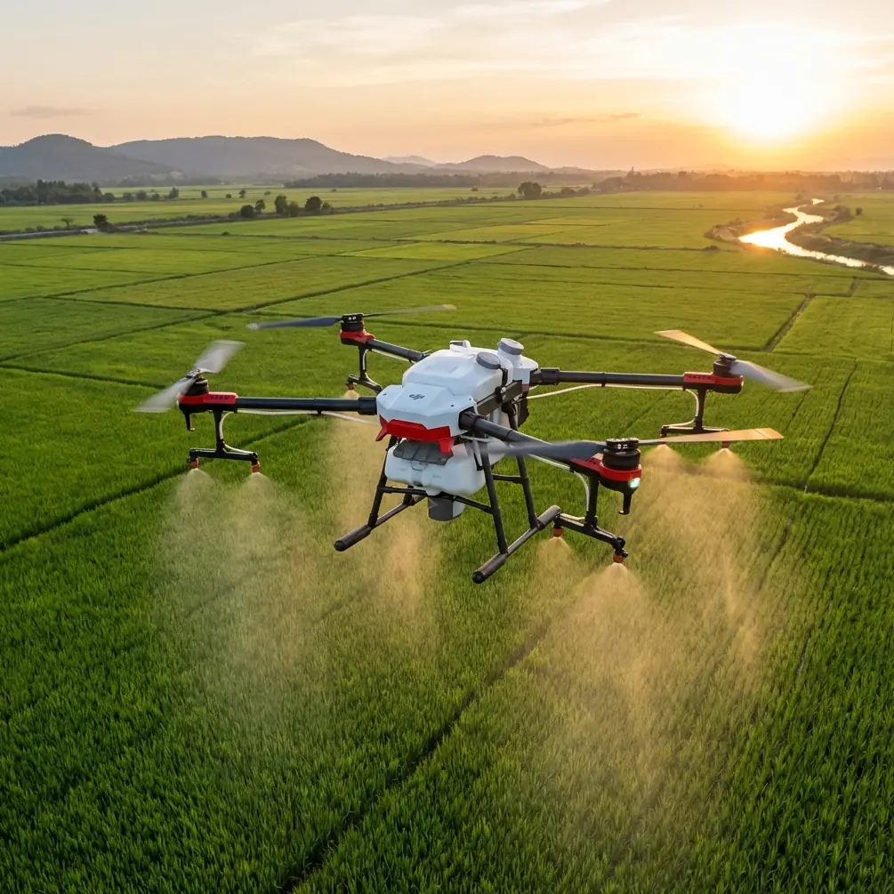
Dust was already hanging low over the plot that morning, the kind of fine powder that gets into everything. The operation began under dry, stable conditions, with the T50 running a predictable pattern over crop rows that had already been mapped for follow-up treatment and monitoring. Then the weather turned. Wind direction changed first. A light burst of moisture followed. Not a dramatic storm, just enough to expose weaknesses in aircraft sealing, contamination tolerance, and control stability.
That is where spec-sheet thinking ends and operational thinking begins.
A machine intended for agricultural use has to tolerate exactly this kind of transition. The moment dust becomes wet grime, every exposed weakness gets tested. If the aircraft struggles with environmental sealing, maintenance burden rises. If it cannot maintain precise routing as conditions shift, overlap consistency suffers and the mission gets messy. If the operator starts second-guessing each pass, output slows.
This is why features associated with robustness matter more than marketing shorthand. The T50 conversation naturally includes terms like IPX6K, RTK fix rate, centimeter precision, swath width, and nozzle calibration because those are the variables that shape field results. Endurance is still part of the equation, but only one part.
The endurance myth, translated for Agras T50 buyers
The “29 minutes+” anecdote from the waterproof-drone article is useful because it captures a reflex many users still have: compare unlike missions and assume the higher raw number wins.
But agricultural drones are not built for empty-air endurance contests. They are built for productive cycles. Once you accept that, the buying criteria sharpen quickly.
A productive T50 sortie is defined by questions like these:
- How much ground was covered with the intended result?
- How stable was the aircraft when the wind shifted?
- Did the RTK fix rate stay strong enough to preserve line accuracy?
- Was spray drift managed acceptably for the crop and field edge conditions?
- Did nozzle calibration remain trustworthy across the mission?
- Was the output usable for the next decision layer, whether treatment logging or crop health review?
That is why the endurance myth is so persistent: people compare a low-load, optics-first mission to a precision-ag mission that is doing much harder work.
The number on paper does not tell you how much useful agricultural work got done.
Where crop survey logic intersects with the T50
Another mistake is to treat spraying and crop survey as separate worlds. In practice, they increasingly overlap.
The ArcGIS crop-survey workflow is a good example. It starts with image capture and leads into orthomosaic generation, interpretation sample points, spatial data management, and agricultural application. That pipeline matters to T50 users because effective field operations now depend on more than application hardware alone. They depend on how well flight data connects to mapping, interpretation, and action.
The source document describes a sample plot of 200 meters by 200 meters where preliminary field boundaries were outlined from satellite imagery, and on-the-ground investigation was needed to determine crop type and planted area for each parcel. That operational setup mirrors a common precision-ag reality: you rarely begin from zero. You begin with partial data, field boundaries that need refinement, and management decisions that depend on better observation.
This is where Agras T50 operations become more strategic.
If the field team is already using orthomosaics, sample points, and managed spatial layers, the aircraft’s role expands. It becomes part of a repeatable information system. The better your field execution, the more reliable your downstream agronomic interpretation. Miss a strip, vary your spacing, or let conditions distort application behavior, and the data chain weakens.
That is why consistency matters more than isolated peak performance.
Multispectral and hyperspectral thinking: not every crop signal is visible to the eye
The most serious agricultural operators are moving past visual inspection alone. They want crop signals that reveal stress earlier and more quantitatively.
The hyperspectral reference material included an especially relevant point: Leaf Area Index, or LAI, is a major canopy-structure parameter used to understand crop biophysical processes and feed growth models and decision-support systems. That is not academic trivia. It tells you what “good crop data” actually means in management terms.
The same source highlighted that red-light reflectance is closely correlated with LAI in multiple crops, and that rice studies identified 671 nm and 682 nm reflectance as especially useful. It also cited vegetation index combinations such as NDVI using 760 and 990 nm, RVI using 760 and 1001 nm, and DVI using 677 and 1070 nm as showing strong correlation with LAI in corn. On top of that, red-edge position, slope, and area were found to have very significant relationships with LAI across corn, rice, and wheat.
Why does this matter in an Agras T50 discussion?
Because field execution and crop sensing are converging. Even if the T50 itself is not being positioned purely as a hyperspectral survey platform, the operator who understands multispectral logic will make better decisions about where and when to treat, how to define management zones, and how to verify results. “Multispectral” is not just a feature word. It is a way of seeing crop variability before it becomes obvious to the naked eye.
If red-edge behavior or near-infrared vegetation indices suggest weaker canopy development in part of a field, that changes how you think about intervention timing. It can also influence how carefully you monitor spray drift near sensitive boundaries or how you plan route order under unstable weather.
The aircraft does not need to do everything by itself. It needs to fit into a better agronomic system.
Dust, moisture, and precision are not separate problems
Operators often discuss dust resistance, water resistance, RTK accuracy, and application quality as if they belong in separate categories. In the field, they merge.
A dusty operation reduces visibility, contaminates surfaces, and increases maintenance pressure. Add a moisture shift mid-flight and that dust can turn tacky fast. At the same time, wind changes can alter droplet behavior, which brings spray drift into focus. If your route accuracy slips while the environment is changing, application uniformity becomes harder to trust. If you have not checked nozzle calibration properly, environmental instability amplifies the error.
This is why the T50 conversation should be framed around system resilience.
Centimeter precision is not a vanity metric. It matters because pass-to-pass consistency affects both overlap and treatment quality. RTK fix rate is not just a line on a brochure. It determines how confidently the aircraft holds the intended path in a real agricultural pattern. Swath width is not just about productivity; it shapes field efficiency and influences how well the operation handles interruptions, edge conditions, and refills.
A machine that holds together under shifting field conditions creates fewer hidden losses.
What smart operators actually evaluate
When experienced users assess an agricultural platform, they usually pay attention to a short list of things that raw flight-time comparisons miss.
First, mission throughput. Not theoretical endurance, but repeatable output over a day.
Second, environmental tolerance. Dust and moisture are not edge cases in agriculture. They are normal.
Third, integration with mapping and agronomic workflows. The old ArcGIS-based crop survey model still holds up because it recognizes that flying is only step one.
Fourth, sensing maturity. The more your operation understands canopy metrics like LAI and spectral behavior in bands such as 671 nm, 682 nm, and the red-edge region, the more intelligently you can use aerial systems overall.
And fifth, operational discipline. That includes route planning, nozzle calibration, drift awareness, and checking whether positioning performance stays solid when the weather shifts.
That is the standard the Agras T50 should be held to.
The bottom line for Agras T50 readers
If you are researching the Agras T50, do not let a single endurance number dominate your thinking. The industry has been conditioned to do that, and it leads people into bad comparisons.
The better question is this: how much dependable agricultural work can the platform complete when conditions are imperfect and the output has to support real field decisions?
The references behind this discussion make that point from two angles. One source shows how easy it is to misread endurance when comparing a waterproof working drone to a casual aerial platform. Another lays out a crop-survey workflow where aerial capture is only the first stage in a larger management system. A third explains why canopy indicators like LAI and spectral signatures around 671 nm, 682 nm, and red-edge features matter for practical crop monitoring.
Put those together and the message is clear.
Agras T50 should be evaluated as a working node in a precision-ag system, not as a flying stopwatch.
If you are building a field program around treatment accuracy, repeatable routes, crop intelligence, and stability when the weather turns halfway through the mission, that is the lens that will keep you out of trouble. If you want to compare setup logic, field workflow design, or how these factors apply to your plots, you can message a field specialist here.
Ready for your own Agras T50? Contact our team for expert consultation.