Agras T50 in Mountain Vineyards: A Practical Field Tutorial
Agras T50 in Mountain Vineyards: A Practical Field Tutorial for Stable Flights, Better Footage, and Cleaner Spray Work
META: A field-focused Agras T50 tutorial for mountain vineyards covering flight stability, antenna positioning, obstacle sensing, swath discipline, nozzle calibration, RTK precision, and filming workflow.
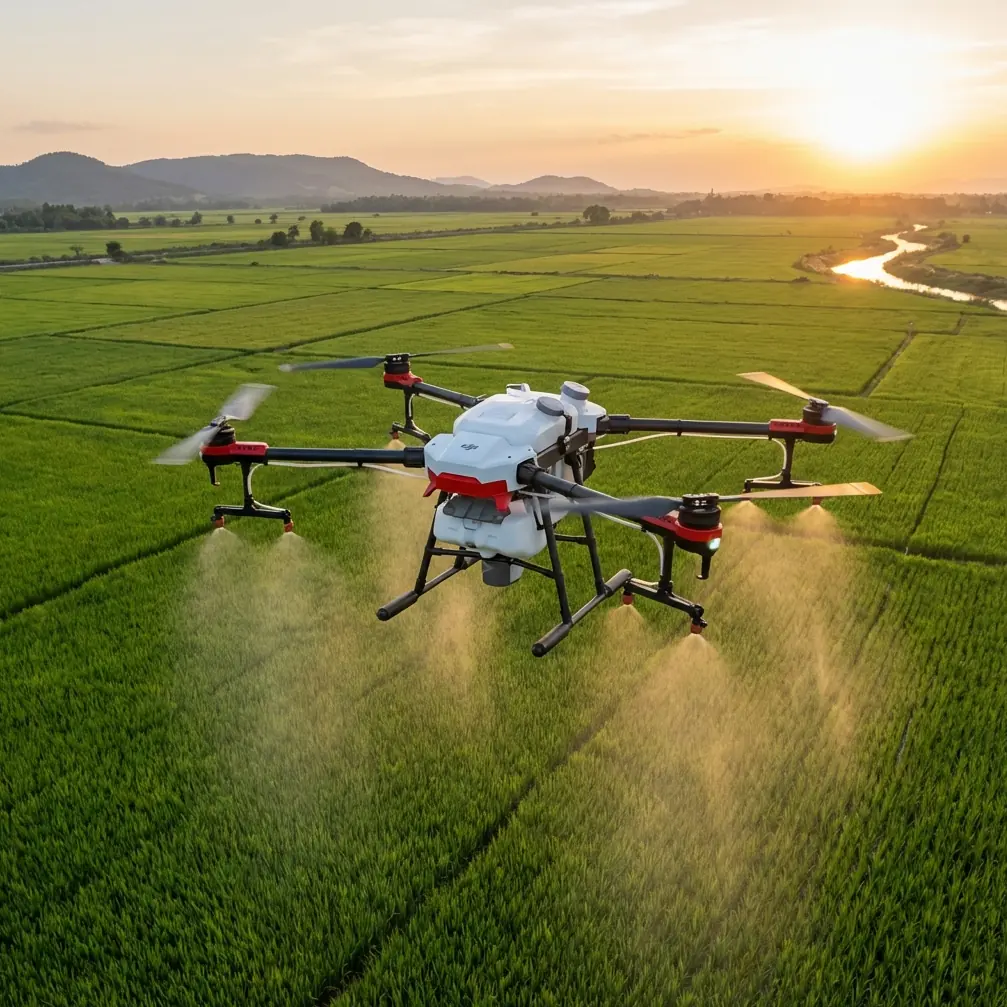
Mountain vineyards ask more from an agricultural drone than flat-row orchards ever will. Slopes break line of sight. Wind changes by the minute. Terraces distort depth perception. A pilot filming and treating vines with an Agras T50 is not just managing a route on a screen; they are managing signal quality, aircraft stability, spray consistency, and visual decision-making at the same time.
That is why the most useful way to think about the T50 in this environment is not as a payload platform first, but as a flying system whose performance depends on sensing, control logic, and operator setup. If you get those pieces right, the rest gets easier: cleaner turns, more stable footage, tighter application accuracy, and less rework on difficult blocks.
Why mountain vineyard work exposes weak habits fast
A mountain site punishes shortcuts. On level ground, an operator can sometimes get away with sloppy route planning, poor antenna orientation, or vague altitude control because the aircraft has room to recover and signal paths are predictable. In steep vineyards, those same habits show up immediately as uneven swath overlap, hesitant autonomous behavior near slope changes, and footage that looks nervous instead of intentional.
Two technical ideas from the reference material explain why.
First, the drone’s flight control system is effectively the aircraft’s brain. The source describes the flight controller as responsible for the whole flying process: takeoff, in-air flight, mission execution, and return. It relies on sensors such as a three-axis gyroscope, acceleration sensor, position sensor, barometric altitude sensing, and an inertial measurement unit to understand attitude, speed, and position. Operationally, that matters because mountain flying constantly changes the relationship between gravity, slope, and airflow. A drone that can continuously correct attitude and motor speed is what keeps the aircraft from wandering off line when the terrain drops away beneath it.
Second, the same source explains that vision and TOF sensing contribute to hovering, navigation, and obstacle recognition. Downward visual sensing provides horizontal movement information, while TOF height and front distance sensing support obstacle avoidance and autonomous navigation. In a vineyard carved into hillsides, that sensor fusion is not a luxury. It is what allows the aircraft to maintain a believable position reference when terrain texture, changing elevation, and canopy edges make manual judgment harder than it seems from the ground.
If you are filming rows while also evaluating spray behavior, this stability is more than a comfort feature. Stable aircraft behavior is what makes your footage readable. You cannot judge drift, canopy penetration patterns, or missed sections from video that is constantly pitching, bobbing, or correcting late.
Start with the control system, not the camera
One of the provided news references is about smartphone photography, and at first glance it seems unrelated. It actually contains a useful lesson for T50 operators: modern phones now have large sensors, high-resolution lenses, and multi-focal-length coverage as standard on many mid-range and flagship models, yet the article argues that better results usually come from understanding native settings and avoiding basic mistakes rather than buying more equipment.
The same logic applies in the field with the Agras T50.
Operators often focus on accessories, export settings, or external monitors when the real gains come from understanding core aircraft behavior and setup discipline. In mountain vineyards, better footage and more reliable spray documentation usually come from:
- choosing the right takeoff point,
- confirming RTK fix quality before launch,
- setting realistic route geometry for slope transitions,
- calibrating nozzles before work begins,
- and positioning the controller antennas properly.
That last point is worth expanding because poor antenna setup is one of the quiet causes of reduced range and unstable control links in hilly terrain.
Antenna positioning advice for maximum range in mountain blocks
If you are operating from a terrace edge or a service road below the vines, do not hold the controller casually against your body and assume the link will sort itself out. Hills, trunks, retaining walls, and even parked vehicles can interrupt the radio path. The best practice is simple: maintain the clearest possible line between the controller and the aircraft, and orient the antennas so their broadside faces the drone rather than pointing the antenna tips directly at it.
In practical terms:
- Stand where you can see the aircraft through the full working segment, not just the launch point.
- Avoid operating from directly behind stone walls, dense vehicles, or metal structures.
- Reposition as the drone moves around ridges or terraces if the route geometry starts to put terrain between you and the aircraft.
- Keep antennas aligned intentionally rather than folded into a random position after transport.
This matters because range loss in vineyards is often not a true power issue. It is a geometry issue. Signal quality drops when terrain and foliage turn a clean path into a blocked or reflected one. A good antenna posture can be the difference between a smooth autonomous pass and a mission pause in the middle of a slope.
If you want a quick field checklist for controller positioning and route setup, this mountain-vineyard signal planning contact is a sensible place to ask before you head into a difficult block.
RTK fix rate and centimeter precision are not just mapping terms
People often talk about centimeter precision as if it only matters for survey work. In a vineyard, it directly affects repeatability. If you are treating narrow rows on a slope, your margin for lateral error is smaller than in broad-acre crops. Better RTK fix consistency helps the T50 hold a cleaner path relative to the row and reduces uncertainty when you return for a second pass or compare treated and untreated zones.
For mountain vineyards, RTK discipline matters in three places:
1. Entry into the row
A poor fix at mission start can shift the aircraft’s relationship to the vines before the first proper pass even begins.
2. Cross-slope transitions
When the aircraft moves between terraces or across changes in elevation, precise positioning supports cleaner route adherence and more consistent swath placement.
3. Repeated documentation flights
If you are filming treatment conditions over several dates, repeatable track positioning makes before-and-after comparisons far more credible.
This is where “centimeter precision” becomes operational instead of promotional. It reduces the ambiguity that mountain terrain introduces.
Swath width on slopes: wider is not always better
Many operators think first about coverage rate. In vineyards on steep ground, the more relevant question is whether the chosen swath width remains honest once wind, terrain contour, and canopy shape begin influencing spray behavior.
A broad swath may look efficient on paper. But if the outer edges of the pattern are inconsistent because of crosswinds or row elevation differences, your effective coverage is smaller than the nominal number. That creates two problems at once: missed sections and unnecessary overlap.
When evaluating swath width in mountain vineyards, focus on:
- canopy density,
- row spacing,
- side wind variability,
- and whether the slope causes the aircraft to sit visually “high” on one side of the row and “low” on the other.
The T50’s value here is tied to controlled repeatability. A slightly narrower but consistent working width is usually better than a headline width that produces uncertain edges. This is also where filming becomes useful. Stable video from repeatable passes can reveal whether your spray distribution changes as the route bends around the hillside.
Nozzle calibration is where drift control really begins
Spray drift is often blamed on weather alone. Weather matters, of course. But drift risk also rises when application hardware is not calibrated properly. In mountain vineyards, where rows may be exposed to side gusts and thermal changes, nozzle calibration becomes even more consequential.
The operational goal is not just output accuracy. It is pattern predictability. If the nozzles are inconsistent, then every slope-induced airflow change magnifies the problem. The aircraft may be flying the correct line while the liquid distribution tells a different story.
Before work begins, treat nozzle calibration as part of mission integrity, not a maintenance afterthought:
- verify output consistency across nozzles,
- confirm the intended droplet behavior for the crop stage and canopy condition,
- check for wear that can distort distribution,
- and reassess after transport over rough mountain access roads.
Why this matters for the T50 specifically: a large-capacity agricultural platform only performs as well as its delivery system. Precision flight with imprecise output still leaves you with uneven biological results and avoidable drift. In vineyards near neighboring plots, roads, or water-sensitive zones, that is not acceptable.
Use the aircraft’s sensing strengths instead of fighting them
The TT training document in the references points out that navigation systems provide spatial coordinates, speed, flight attitude, and obstacle information, essentially acting as the aircraft’s navigator. It also notes that TOF sensors under the aircraft and on the forward module form part of the obstacle-avoidance system, giving the drone the ability to recognize obstacles and navigate autonomously.
This is highly relevant to the T50 in mountain vineyards, where poles, trellis edges, netting structures, and rising terrain can confuse an operator who is trying to film and supervise treatment at once.
A practical mistake I see often is the operator mentally treating obstacle sensing as a fallback for emergencies rather than as an active part of the workflow. In reality, you should plan the mission around what the aircraft senses well and where that sensing may be challenged. For example:
- abrupt lighting shifts between open slopes and shaded terraces can change how visual references appear,
- netting and fine wires may require more conservative route planning,
- and ridge lines can alter your perception of distance faster than the aircraft’s own measurement logic.
Trusting the aircraft does not mean becoming passive. It means building route geometry and operating position around the strengths of the sensing stack.
Stable response matters more in wind than most operators admit
One reference about aerobatic aircraft control surfaces contains an idea that translates surprisingly well to agricultural drone handling: design choices that improve response consistency across varying speeds and windy conditions can raise control performance significantly. The source even cites a 50% improvement in control performance for a specific control-surface approach in aerobatic contexts.
A multirotor like the Agras T50 is a different machine, but the lesson holds. In mountain vineyards, the issue is not only whether the drone can resist gusts. It is whether the aircraft’s response remains predictable as wind shifts around slopes and canopy gaps. That predictability affects manual interventions, route supervision, and the quality of any footage you capture for agronomic review.
For the operator, this means three things:
Do not judge wind only from the launch site.
Terrace funnels and ridge edges can produce local behavior that the ground does not reveal.Watch response consistency, not just top-line stability.
Small delays or extra corrections during turns are warning signs.Film with evaluation in mind.
Good footage is not cinematic decoration. It is evidence of how the aircraft behaved through the block.
IPX6K matters in real farm work because vineyards are messy
Mountain vineyard work is rarely clean. Spray residue, dust from access roads, moisture, and repeated field transport all add stress to the aircraft. An IPX6K-rated airframe matters because it supports survivability in harsh agricultural conditions and simplifies post-operation cleaning discipline. That does not remove the need for careful maintenance, but it does make the platform better suited to the realities of repeated vineyard deployment than lighter-duty systems.
The key is to treat durability as uptime protection. Less unplanned downtime means more consistent treatment windows, especially when weather and labor schedules leave little flexibility.
A simple filming workflow that actually helps operations
If your scenario includes filming vineyards in the mountains, keep the workflow purposeful.
Before flight
Capture a short overview of wind direction indicators, row orientation, and terrain breaks.
During route execution
Record stable lateral or elevated perspectives that let you review path holding, height consistency, and turn behavior.
After flight
Compare footage with nozzle setup notes, RTK fix quality, and observed drift behavior.
This turns video into an agronomic record. It becomes easier to answer practical questions: Did the aircraft maintain even height over the terrace break? Did the outer swath degrade near the ridge? Was the route too aggressive for the day’s wind? That is far more valuable than simply collecting dramatic aerial clips.
The real skill with an Agras T50 in mountain vineyards
The highest-level T50 operators are not the ones who only memorize specs. They are the ones who understand interaction: control system, sensors, terrain, spray hardware, and operator position all influencing one another.
The reference materials underline that principle in different ways. The drone training source emphasizes the central role of the flight controller, IMU, vision sensing, and TOF-based navigation. The smartphone photography piece reminds us that results improve when users understand the native system and avoid beginner mistakes instead of chasing complexity. Even the aerobatic control reference reinforces the value of consistent response under changing airflow and speed conditions.
Put together, the lesson is clear. In a mountain vineyard, the Agras T50 performs best when the operator respects fundamentals:
- strong RTK fix rate,
- careful antenna positioning,
- honest swath width choices,
- rigorous nozzle calibration,
- and a filming workflow that supports agronomic decisions.
That is how you get cleaner coverage, lower spray drift risk, more reliable footage, and fewer surprises when the slope and wind start testing your setup.
Ready for your own Agras T50? Contact our team for expert consultation.