Agras T50 in Mountain Operations: A Technical Review
Agras T50 in Mountain Operations: A Technical Review for Demanding Terrain
META: Expert review of the Agras T50 for mountain work, with practical insight on control logic, hovering precision, battery management, spray drift, and why DJI-style flight automation matters in steep terrain.
Mountain work exposes every weakness in a UAV system. Wind rolls off ridgelines unpredictably. GPS quality can vary with slope angle and canopy cover. Launch areas are often improvised, cramped, and uneven. If you are evaluating the Agras T50 for steep agricultural blocks or support work around mountain venues, the real question is not whether the aircraft is powerful on paper. It is whether the operating logic behind it reduces friction when the terrain is trying to multiply it.
That distinction matters more than spec-sheet theater.
The reference material behind DJI’s rise points to two features that changed the industry: integrating GPS with the aircraft so it could hold position automatically, and reducing the operational barrier so drones stopped being tools only for hobbyist builders. That historical shift is directly relevant to the Agras T50 today. In mountain conditions, automatic hovering is not a convenience feature. It is a workload reducer. On a narrow terrace or temporary takeoff point beside a slope road, stable hover behavior buys the pilot time to assess rotor wash, nearby obstacles, and route alignment before committing to the run.
Older multirotor generations made operators work harder just to maintain a safe stationary hold. DJI’s earlier Phantom line showed how much this changed. One model introduced one-tap takeoff through the app, then climbed to a preset height and held position automatically. Another milestone was precise hovering support through GPS and, in lower-altitude GPS-poor environments, sensing the ground below using visual and ultrasonic inputs. Those details came from camera drones, not agricultural platforms, but the operational philosophy is the same: lower the control burden, preserve pilot attention for mission decisions, and convert automation into usable safety margin.
For mountain agriculture, that is exactly the right design direction.
Why control simplification matters more in the mountains
Flatland spraying rewards throughput. Mountain spraying rewards stability, repeatability, and operator judgment under constraint. On a steep site, the pilot often has to think about three layers simultaneously: aircraft positioning relative to terrain, coverage quality relative to crop geometry, and energy management relative to distance from the landing zone. Any feature that strips away unnecessary manual effort improves the quality of the remaining decisions.
The source material describes DJI’s market leadership as a result of a “low operating threshold,” lower cost structure, and technical advantage. That sounds broad, but in practice it explains why professional users keep favoring systems that feel predictable under pressure. In a mountain scenario, the aircraft must not become another variable to fight. The best systems act like force multipliers for concentration.
This is where an Agras T50 discussion should be grounded. Not in abstract enthusiasm, but in how the aircraft fits a broader DJI logic that has been refined for years: stable flight control, intelligent protection functions, simplified takeoff behavior, and dependable return logic. The Phantom 3 references are especially useful here. It offered 720P live video to the mobile device, improved attitude algorithms, and one-key takeoff and return-to-home behavior. Again, that is legacy imaging hardware, yet the lesson carries over. In mountain work, strong situational awareness and low-friction controls reduce preventable errors.
A stable machine is not merely easier to fly. It preserves cognitive bandwidth for terrain-aware operations.
Agras T50 and the real mountain workload
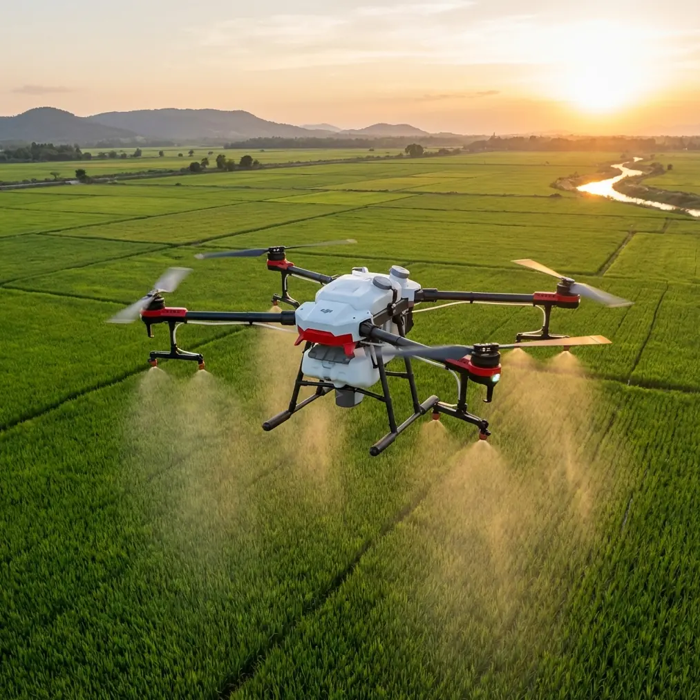
Although the T50 is built for agricultural operations rather than filming, many mountain venue readers are actually dealing with overlapping needs: orchard or hillside crop management near event properties, resort landscaping, tea terraces, vineyard blocks, or large scenic estates where aerial work must happen in visually sensitive, logistically awkward locations. In these settings, the T50’s value is tied to consistency.
Two concepts deserve special attention: spray drift and nozzle calibration.
Spray drift becomes far more consequential on mountain sites because air does not move in straight, intuitive patterns. A calm launch point can hide lateral movement higher up the slope. Rotor downwash may interact with updrafts coming off sun-warmed faces. Even if the aircraft is holding track well, poor droplet behavior can erode application quality and create unwanted deposition beyond the intended swath width.
That is why nozzle calibration should never be treated as a setup chore to rush through at the truck. On steep terrain, a small mismatch in output can become visible quickly because the crop geometry already introduces uneven exposure angles. Calibration affects not just volume, but the balance between droplet size, penetration, and drift behavior. If your operation includes variable slope sections, it is worth logging calibration checks by field block rather than assuming one morning baseline will hold all day.
The T50 conversation also naturally intersects with RTK fix rate and centimeter precision, even if the operational objective is not survey-grade mapping in the traditional sense. In mountain agriculture, line fidelity matters. Every pass over a terrace edge, every turn above a retaining line, every transition between narrow rows benefits from accurate positioning. “Centimeter precision” is only meaningful if the fix remains dependable under local conditions, so the practical metric is not merely RTK availability but how consistently the aircraft maintains a reliable fix around slope transitions, partial obstructions, and changing sky view.
In short: precision is not a checkbox. It is a behavior.
A battery management habit that saves mountain operators trouble
Field experience has taught me that mountain operators often underestimate battery strain not because the aircraft lacks endurance, but because the site punishes optimism. Elevation changes, repeated repositioning, hover checks before each run, and cautious approach paths can quietly consume more energy than the mission plan suggests.
My preferred habit is simple. Do not evaluate pack readiness only at the moment of launch. Evaluate it at the moment you expect to be back over the landing zone with a margin for one disrupted approach.
That margin matters.
The older DJI material referenced a smart battery system that calculated remaining energy relative to return and landing needs, while also displaying pack status, temperature, and cell balance in the app. That logic remains instructive for T50 operators. A battery is not just a fuel tank. It is a dynamic risk indicator. On mountain sites, temperature spread between batteries sitting in shade and aircraft operating in direct sun can affect consistency over a long day. Cell balance trends are worth watching early, not after a weak pack reveals itself halfway through a remote block.
My rule in the field is to rotate batteries deliberately and annotate any pack that shows unusual voltage sag after aggressive climb segments or after repeated short-hop deployments between terraces. Those are the packs that may still look serviceable in a casual glance yet behave differently under load. If your landing area is confined or downhill from the active work zone, be stricter, not looser, with swap thresholds.
A mountain mission rarely fails because one number looked dramatic. It fails because several small inefficiencies stacked up.
The hidden operational model behind the T50’s appeal
One of the most useful references in the source documents is not about hardware at all. It is the observation that the UAV industry’s future value delivery extends beyond products into services: customized solutions, data collection and analysis, professional operation, and technical training. That is especially relevant for the Agras T50.
A serious mountain deployment should not be framed as “buy aircraft, then improvise.” It should be structured as a service system. The aircraft is one layer. The other layers are route planning, operator training, terrain-specific SOPs, nozzle setup, battery discipline, maintenance intervals, and, where needed, data capture to verify coverage patterns or crop response. That service-oriented view is often what separates sustainable mountain operations from machines that perform well only in demonstrations.
For teams trying to build that operating system, a direct technical discussion can save months of trial and error; this is often easier through a field-focused channel such as our mountain operation support line.
The source material also described a startup that had product design and R&D capability but weak links across the rest of the industry chain. That is a familiar problem in UAV adoption. Good aircraft do not automatically create good workflows. In mountain environments, the supporting chain matters even more: pilot onboarding, spare planning, battery rotation protocol, and response procedures for signal interruptions or sudden weather shifts. The T50 makes the most sense inside a mature support framework.
What DJI’s earlier consumer breakthroughs tell us about T50 readiness
At first glance, Phantom-era references may seem distant from an agricultural flagship. They are not. They reveal the company’s underlying method.
One early Phantom offered “ready to fly” operation with no DIY assembly burden and a maximum speed of 10 m/s, plus 10 to 15 minutes of flight time. Another generation added 720P live transmission, app-based one-tap takeoff, and automatic return when signal was lost or battery reserves fell too low. The significance is not nostalgia. It is engineering continuity. DJI repeatedly removed procedural complexity from the pilot’s side while increasing the aircraft’s contribution to safe execution.
For a platform like the Agras T50, that matters because agricultural work at scale is won by routine reliability. On a mountain site, “ready to work” is the professional equivalent of “ready to fly.” You want the aircraft to start from a predictable baseline every time, not demand extra setup energy from the crew when terrain and weather are already draining enough of it.
This same philosophy supports training outcomes. Lowering the operating threshold does not mean lowering standards. It means new operators can reach a safe, repeatable baseline faster, then spend more of their learning cycle on mission quality: drift control, swath width management, turn efficiency, and block-specific adjustments. That aligns closely with one of the source document’s most practical forecasts: technical training itself becomes part of the value chain.
Where mountain operators should focus their evaluation
If you are assessing the Agras T50 for mountain use, do not start with headline payload narratives alone. Start with these questions:
- How stable is the aircraft’s positioning behavior during short hover pauses near slope transitions?
- How dependable is your RTK fix rate in the actual field geometry you intend to work?
- Can your team calibrate nozzles consistently enough to control drift and preserve intended swath width?
- Is your battery swap discipline conservative enough for uphill return paths and disrupted approaches?
- Do your operators understand when automation is reducing workload and when terrain still demands manual caution?
Those questions are less glamorous than brochure claims, but they are the ones that determine whether the T50 performs as a professional tool rather than a promising machine.
Final assessment
The best way to understand the Agras T50 in mountain operations is to see it as the current expression of a long DJI pattern. The company’s rise was built on integrating positioning intelligence, stabilizing flight behavior, and lowering the practical barrier to effective use. Earlier systems proved the value of features like automatic hovering, one-touch takeoff, visual-assisted low-altitude positioning, live video downlink, and automatic return logic. For mountain agriculture, those principles are not side notes. They are the architecture of trust.
The T50 belongs in that lineage.
Used well, it can help crews manage the hardest part of steep-terrain work: maintaining precise, repeatable output when the environment is constantly trying to disrupt it. But its real strength appears only when matched with disciplined nozzle calibration, realistic battery planning, attention to spray drift, and a service mindset that treats training and operating procedure as core assets rather than afterthoughts.
That is the standard mountain work demands. The Agras T50 is worth evaluating against exactly that standard.
Ready for your own Agras T50? Contact our team for expert consultation.